Rainfall Reports | Phenomenal One Hour Rainfall | Meteorology | Flooding Reports & Photos | Lake County, IN Flash Flooding
|
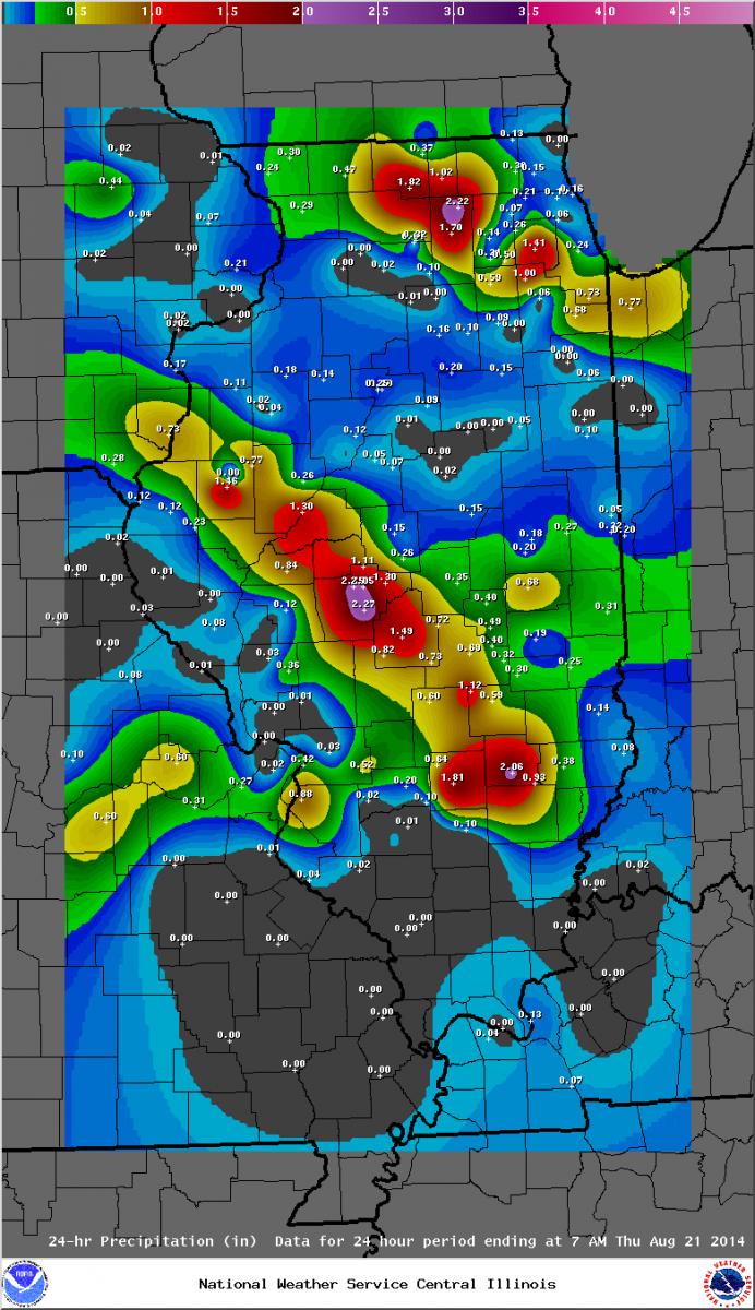
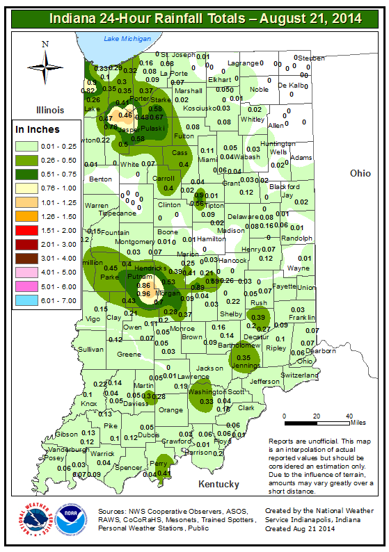
24-hour Rainfall Ending 7 am August 21, 2014 |
|
|
Illinois |
Indiana |
|
|
|
|
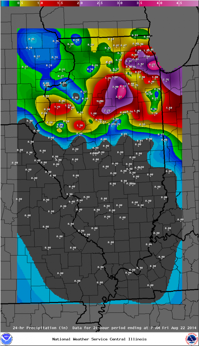
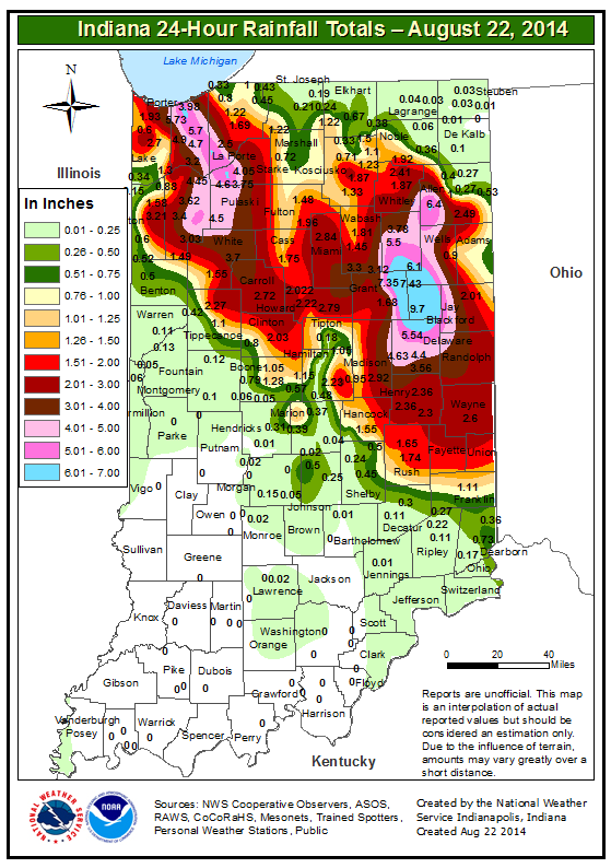
24-hour Rainfall Ending 7 am August 22, 2014 |
|
|
Illinois |
Indiana |
|
|
|
|
Doppler Radar Estimated Rainfall from Wednesday Night Through 7 am Friday Morning |
 |
Highest 48-hour Rainfall Totals Through 7 AM August 22, 2014:
ILLINOIS                                 2-DAY RAINFALL
  LOCATION (COUNTY):                         AMT(IN)

  MIDWAY COOP (COOK)...........................6.12
  ST CHARLES 1SW (KANE)........................5.48
  WESTMONT 1SSE (DU PAGE)......................5.30
  GLEN ELLYN (DU PAGE).........................5.20
  SUBLETTE (LEE)...............................5.08
  DWIGHT 4NNW (GRUNDY).........................5.05
  OAK LAWN (COOK)..............................5.05
  WESTMONT (DU PAGE)...........................5.04
  CHICAGO RIDGE (COOK).........................5.01


INDIANA                                    2-DAY RAINFALL
  LOCATION (COUNTY):                         AMT(IN)

  VALPARAISO 2NW (PORTER)......................6.29
  VALPARAISO 1SE (PORTER)......................6.14
  VALPARAISO 6NW (PORTER)......................6.00
  VALPARAISO 1NE (PORTER)......................5.93
  RENSSELAER 5E (JASPER).......................5.55
  WHEATFIELD 3S (JASPER).......................5.45
  WHEATFIELD 2ENE (JASPER).....................5.32
  VALPARAISO 4SW (PORTER)......................5.11
  VALPARAISO 2WNW (PORTER).....................5.10
  VALPARAISO (PORTER)..........................5.07
  (KB9F)VALPARAISO 4S (PORTER).................5.05
For a full listing of area rainfall totals in these 48 hours, visit here.
-----------------------------------------------------
Highest 24-hour Rainfall Totals Through 7 AM August 22, 2014:
THE FOLLOWING ARE RAIN AMOUNTS FOR THE PREVIOUS 24-HOURS
   AS MEASURED IN THE MORNING BY NWS COOPERATIVE OBSERVERS
   AND COCORAHS OBSERVERS.
   OBSERVATIONS ARE USUALLY TAKEN BETWEEN 6 AND 8 AM.


ILLINOIS                                       RAIN
  LOCATION (COUNTY):                           FALL (IN)

  MIDWAY COOP (COOK)...........................5.55
  SUBLETTE (LEE)...............................4.78
  MIDWAY (COOK)................................4.22
  MARSEILLES (LA SALLE)........................4.12
  ELMHURST 1ESE (DU PAGE)......................4.10
  OAK LAWN 2WNW (COOK).........................3.68
  WESTMONT (DU PAGE)...........................3.63
  OAK PARK 2S (COOK)...........................3.59
  ELMHURST (DU PAGE)...........................3.55
  ELK GROVE VILLAGE 1ESE (COOK)................3.52
  STREATOR (LIVINGSTON)........................3.52

INDIANA                                        RAIN
  LOCATION (COUNTY):                           FALL (IN)

  PORTAGE 3E (PORTER)..........................6.82
  VALPARAISO 6NW (PORTER)......................5.73
  VALPARAISO 2N (PORTER).......................5.10
  VALPARAISO 4SW (PORTER)......................4.90
  VALPARAISO 2WNW (PORTER).....................4.84
  VALPARAISO (PORTER)..........................4.81
  (KB9F)VALPARAISO 4S (PORTER).................4.70
  PORTAGE 1ESE (PORTER)........................4.49
  (W9OPR)WHEATFIELD 1ENE (JASPER)..............4.45
  WHEATFIELD 3S (JASPER).......................4.41
  PORTER 1S (PORTER)...........................3.98
  HOBART 1NNW (LAKE)...........................3.96
  VALPARAISO 6WSW (PORTER).....................3.93
  (WV90)HOBART 1ENE (LAKE).....................3.85
  KOUTS 3SSW (PORTER)..........................3.74
  VALPARAISO 6SSW (PORTER).....................3.72
  WHEATFIELD 2ENE (JASPER).....................3.64
For a full listing of area rainfall totals in these 24 hours, visit here.
The National Weather Service Cooperative Observer at Midway Airport 3SW located in Burbank, IL reported a one hour rainfall of 3.95 inches on August 22, 2014.
The observer noted this was the highest hourly rainfall rate in his period of record at Midway Airport 3SW, which dates back to 1980!
In addition, this observer reported 3.60 inches in just a 40 minute span of that one hour!
|
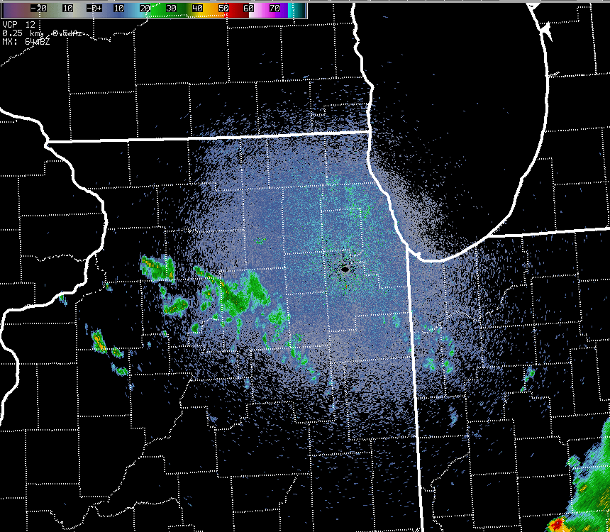
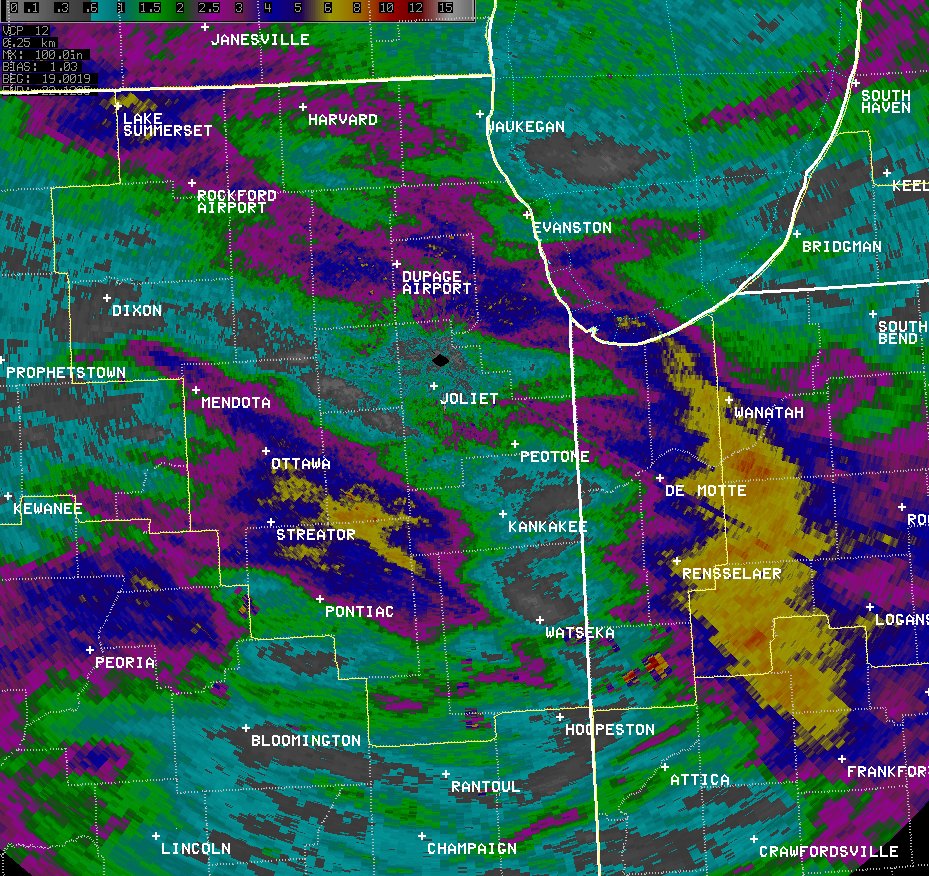
NWS Chicago Doppler Radar 0.5° Reflectivity Loop: August 21, 10 pm - August 22, 7:30 am |
|
|
This was a classic setup for heavy rain across Northern Illinois and Northwest Indiana. When predicting and analyzing heavy rainfall, research and forecasting experience have shown these elements as critical:
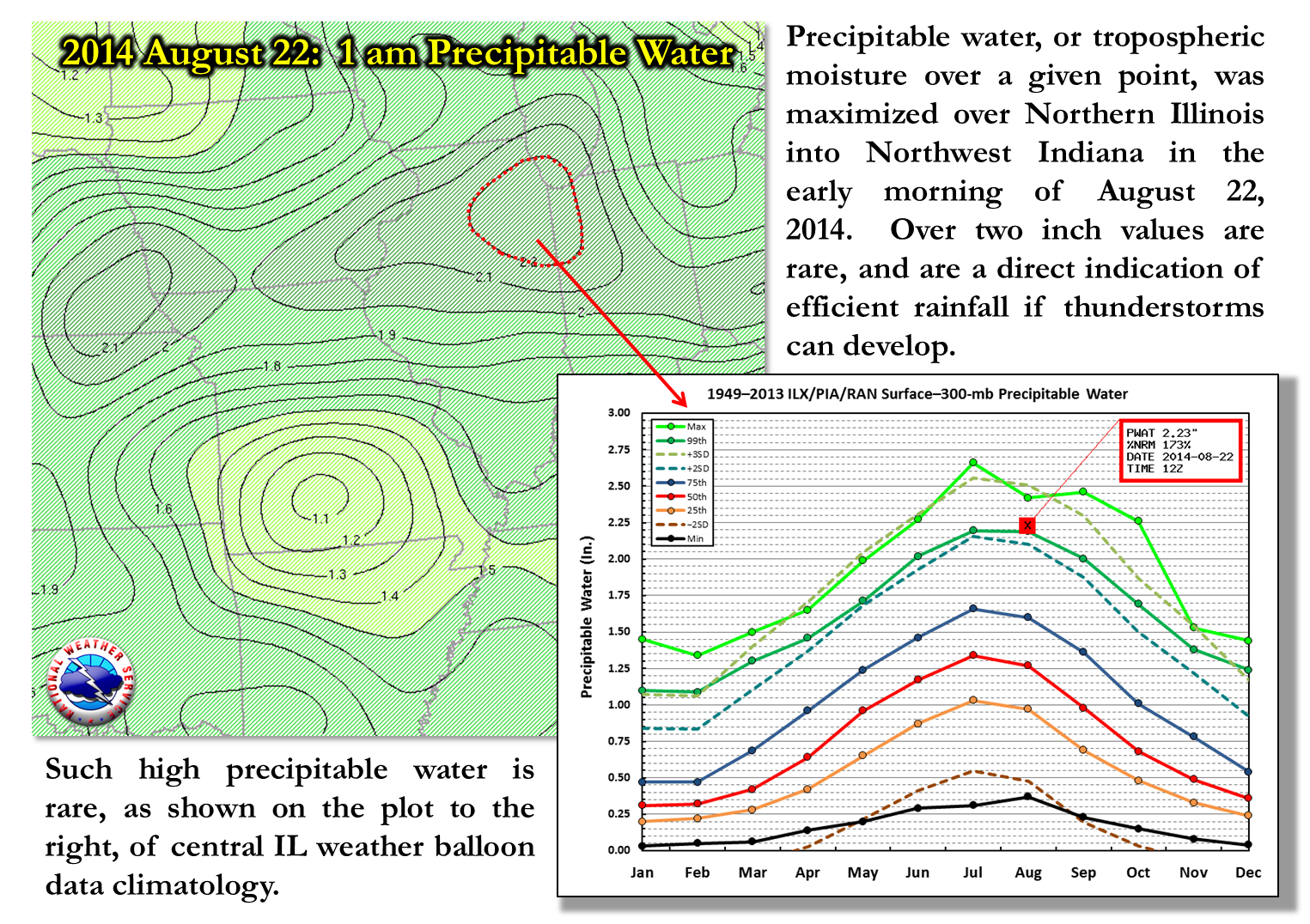
All of these were established over the region late on August 21st into the early morning of the 22nd. For high concentration of moisture, we look at moisture through the depth of the atmosphere, namely the troposphere which is the lowest part where most weather occurs.
|
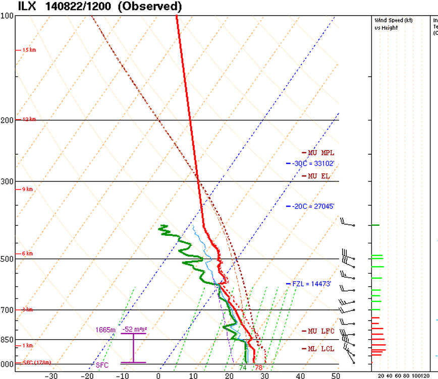
NWS Lincoln, IL Weather Balloon Data on August 22, 2014 @ 6 am |
|
|
|
This weather balloon data from the NWS Central Illinois Weather Forecast Office in Lincoln, IL sampled this heavy rainfall event well, as it was basically the atmosphere over northern IL very early on the morning of August 22nd. Note the very high dew point air (the values of the green line), which were all at levels indicative of very heavy rainfall (850mb Td of 16°C and 700mb Td of 8°C). In addition, the freezing level was over 15,000 ft above ground level. This means deep warm cloud processes were at work, ideal for collision and coalescence o rain drops for effective rainfall rates. |
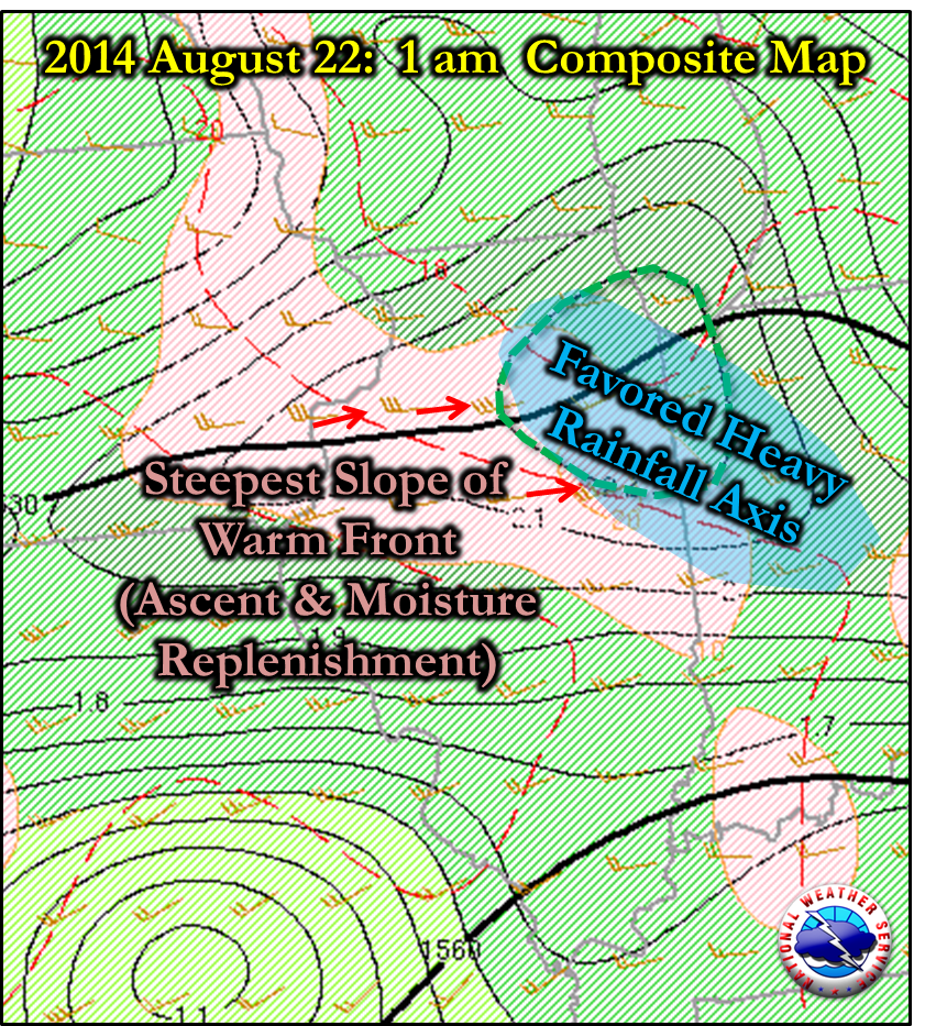 |
|
This composite map shows focus and replenishment through moisture transport which were aligned over parts of the Chicago metro area into Eastern Illinois and Northwest and Central Indiana. |
|
|
|
|
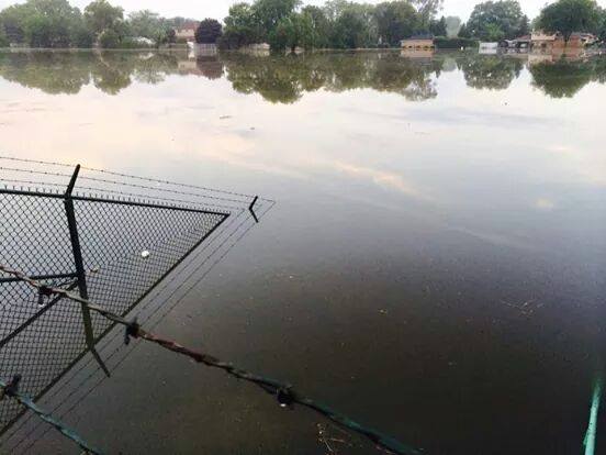
Flooding in Burbank, IL in Cook County. Courtesy of Tom Hewson. |
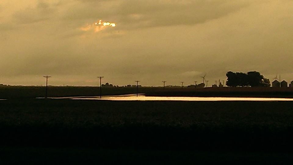
Flooding near Seneca, IL in LaSalle County. Courtesy of Chad Paulson. |
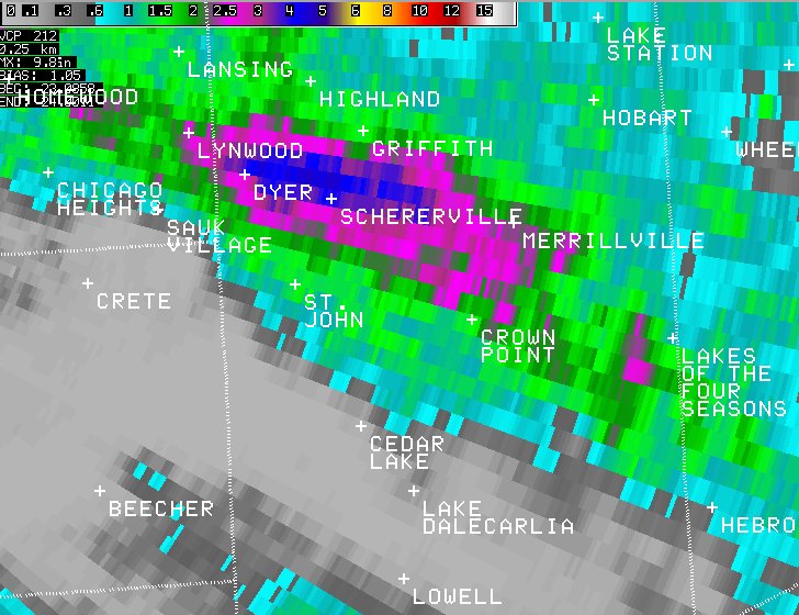
Lake County, IN Flooding of August 23, 2014
Between 2:30 and 3:30 pm CDT, Lake County, IN experienced incredible rainfall rates over a 30-60 min period. As much as 3.65 inches in one hour was observed in Dyer, IN! This was the second time in two days where rainfall of over 3.50 inches in an hour fell somewhere in the NWS Chicago Forecast Area, after 3.95 inches near Midway 3SW. The rain over Dyer produced flash flooding including numerous stalled cars on flooded roadways. In addition, the Hart Ditch rose from near 2 ft to almost 12 ft in less than an hour.
|
August 23, 2014: Total Rainfall (most fell between 2:30-3:30 pm CDT) |
|
|
|
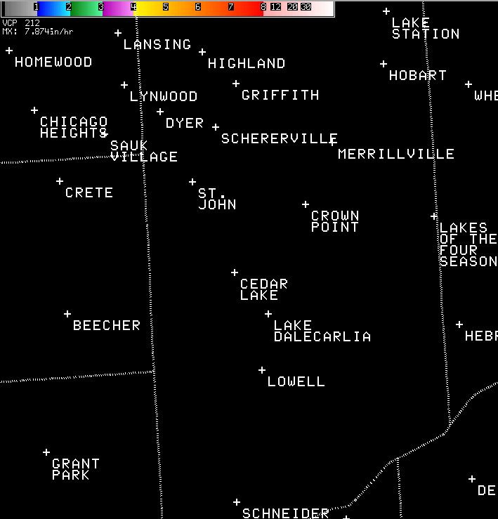
August 23, 2014: 2:15 pm - 3:30 pm Digital Precipitation Rates (in/hr) |
|
|
|
August 23, 2014: 2:15 pm -3 :30 pm Ratio of 1-hour Rainfall to 1 hour Flash Flood Guidance |
|
|