National Weather Service United States Department of Commerce


There is a Slight Risk of severe thunderstorms across nearly all of our Four-State area beginning from roughly noon today until around midnight tonight. The primary threat is damaging winds, but the tornado threat has expanded slightly from previous forecasts. Large hail and localized flash flooding will also be possible.
There is a chance for severe thunderstorms throughout much of this afternoon and evening as a deep trough and a cold front sweep across our Four-State area through tonight. The graphic above represents the most likely timing of potential severe weather impacts across the region.
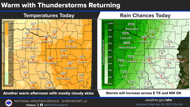
Showers and thunderstorms will begin to rapidly develop and increase in coverage later today, especially by this afternoon and continue through this evening/overnight before exiting all of the region after midnight. This will be the first widespread rainfall event across our area so far this month, spanning over 3 weeks since the last beneficial rain back in late September.
Here are the daily climate records for selected sites across our Four-State area.

Latest Text Product Selector (Selected product opens in a new window)


 Current Weather Observations...
Location Time
(CDT)
Weather Vsby.
(SM)
Temp.
(ºF)
Dewpt.
(ºF)
Hum.
(%)
Wind
(mph)
Wind Chill / Heat Index
(ºF)
Pres.
(in)
De Queen AR15:53Lightning Observed10686693WNW 3-29.78
El Dorado AR15:53Mostly Cloudy10866753S 13-29.73
Henderson TX15:55Clear10877158SW 593 [HI]29.77
Idabel OK15:55Light Rain \ Mist56666100E 5-29.76
Longview TX15:53Lightning Observed10837167SW 8-29.74
Lufkin TX16:05Light Rain \ Lightning Observed10807584W 5G17-29.77
Monroe LA15:53Mostly Cloudy10886648S 9G16-29.77
Mount Pleasant TX15:55Light Rain10666493N 6-29.80
Nacogdoches TX15:56Thunder In The Vicinity \ Lightning Observed10857367SW 692 [HI]29.77
Natchitoches LA15:55Lightning Observed10847062SSE 12-29.76
Shreveport LA (Regional Airport)15:56Light Rain With Thunder \ Cumulonimbus Clouds, Lightning Observed8807583SSE 8-29.74
Shreveport LA (Downtown Airport)16:11Thunder In The Vicinity \ Lightning Observed10817376SSW 8-29.76
Texarkana AR14:42Heavy Rain With Thunder \ Lightning Observed1 3/4807379SW 17G26-29.76
Tyler TX15:53Clear10877159S 1093 [HI]29.76


Submit Storm Report Local Shreveport Radar Local Hazards Forecast Maps Graphical Forecasts Rivers and Lakes
Submit Storm Report Local Shreveport Radar Local Hazards Local Forecast Page Graphical Forecasts Rivers and Lakes
           
Current Observations Aviation Weather Fire Weather CoCoRAHS Information Hourly Forecasts Tropical Weather
           
Drought Information COOP Program Latest Public Information Statement Weather Radio Past Events Storm Spotter Training
Drought Information Cooperative Observer Program Public Information Statement Weather Radio Past Events Spotter Training