National Weather Service United States Department of Commerce

Strong to Severe Thunderstorms from the Southern Plains to the Ohio Valley; Heavy Rain and Flooding in the Southern Plains

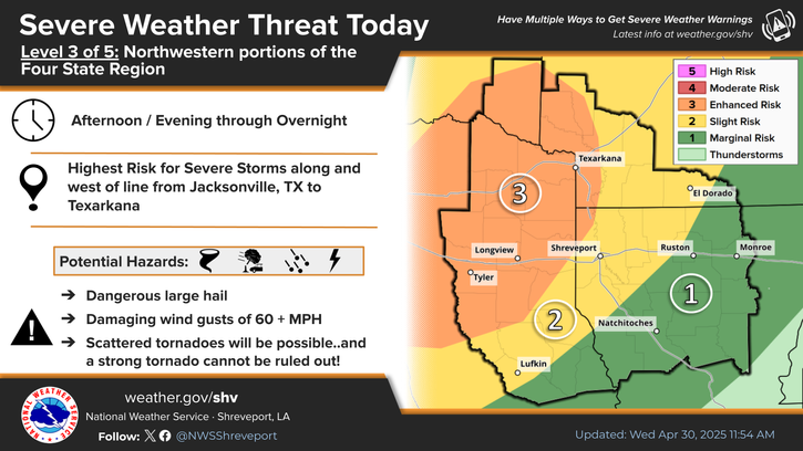
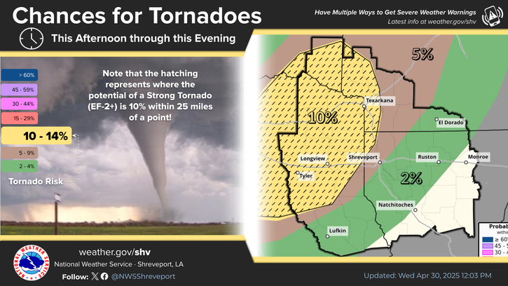
Severe thunderstorms are expected from central Texas to middle Tennessee and Kentucky this afternoon into tonight. Large hail and damaging winds are the main threats. Heavy to excessive rainfall may produce areas of flooding today and tonight from central Texas into the lower Mississippi Valley. Read More >

Click a location below for detailed forecast.

Last Map Update: Sat, May 3, 2025 at 12:08:27 pm CDT


The threat of heavy rainfall and flash flooding will return across the region on Tuesday into Tuesday night as the next major storm system arrives next week. Given our already saturated soil conditions, flooding concerns will only be exacerbated with additional rises on area lakes and rivers also expected for next week and beyond.
Expect pleasant spring conditions over the next 24 hours as post-frontal northwesterly winds allow the Four State Region to dry off under mostly sunny/clear skies.
Here is the daily climatology from select sites around the Four State Region.

Latest Text Product Selector (Selected product opens in a new window)


 Current Weather Observations...
Location Time
(CDT)
Weather Vsby.
(SM)
Temp.
(ºF)
Dewpt.
(ºF)
Hum.
(%)
Wind
(mph)
Wind Chill / Heat Index
(ºF)
Pres.
(in)
De Queen AR10:53Clear10664852VRB 6-30.00
El Dorado AR10:53Mostly Clear10725555WNW 8-29.96
Henderson TXOldN/AN/AN/AN/AN/AN/A-N/A
Idabel OK11:35Clear9665159NW 9G17-30.03
Longview TX10:53Clear10694948NW 14-30.01
Lufkin TX10:53Clear10725045N 12G17-30.01
Monroe LA11:21Partly Cloudy10736165NW 12G17-29.95
Mount Pleasant TX11:35Clear10684949NW 14-30.04
Nacogdoches TX10:56Clear705151NNW 12-30.02
Natchitoches LA11:35Partly Cloudy10716068NW 8G16-29.98
Shreveport LA (Regional Airport)10:56Mostly Clear10735146NW 13-29.99
Shreveport LA (Downtown Airport)10:53Clear10715556NNW 8-29.99
Texarkana AR11:05Clear10724842N 9-30.00
Tyler TX09:53Clear10664954NNW 14-30.03


Submit Storm Report Local Shreveport Radar Local Hazards Forecast Maps Graphical Forecasts Rivers and Lakes
Submit Storm Report Local Shreveport Radar Local Hazards Local Forecast Page Graphical Forecasts Rivers and Lakes
           
Current Observations Aviation Weather Fire Weather CoCoRAHS Information Hourly Forecasts Tropical Weather
           
Drought Information COOP Program Latest Public Information Statement Weather Radio Past Events Storm Spotter Training
Drought Information Cooperative Observer Program Public Information Statement Weather Radio Past Events Spotter Training