Overview
Hurricane Debby made landfall in north Florida on the morning of Monday, 8/5. Debby then slowly tracked northeastward into Georgia and South Carolina before moving offshore and meandering just off the coast. Debby made a second landfall in South Carolina as a tropical storm during the very early morning hours of Thursday, 8/8. Debby quickly began transitioning into an extratropical cyclone as it interacted with a cold front draped just to the north of the Wakefield CWA. The outer rain bands associated with Debby spread into southern VA and northern NC during the night of 8/7 and early morning on 8/8. As is typical with tropical cyclones, a few tornadoes were observed in NC during the morning of 8/8 as Debby tracked northwest roughly following the NC/SC border. The main impacts from Debby in the Wakefield CWA came from Thursday afternoon through the early morning on Friday (8/9) as Debby tracked into west-central NC before accelerating to the north as it got picked up by an trough aloft and completed its transition into a post tropical cyclone. Several low-topped supercells moved into south and southeast portions of the Wakefield CWA (SE VA and NE NC) during the afternoon of 8/8 and these exhibited moderate to briefly strong rotation. No tornadoes have been confirmed from these cells. However, Debby's strongest (and only confirmed) tornado in our CWA occurred just before 7 PM on 8/8 as a high-end EF-1 with 100-110 mph winds tracked across Lake Caroline. Cells continued to exhibit transient moderate rotation through the night and into the early morning of 8/9. Tornado Watches were in effect for at least some portion of the AKQ CWA for nearly 36 consecutive hours!
In addition to the tornadoes, between 2 and 4 inches of rain (locally 5") fell across our portion of the VA Piedmont on 8/8, prompting a few Flash Flood Warnings from Farmville to Clarksville/South Hill. A nearly stationary band of very heavy rain set up across western portions of Prince Edward County between 11:30 PM and 1:30 AM (on 8/9). This produced another 3 to 5 inches of rain, so storm totals in that portion of the county ranged from 7-10" (which was verified by gages). Multiple roads were impassable, and there was a swift water rescue on route 608 near the Appomattox River west of Farmville.
Given the track of Debby, wind impacts were not as much as we have seen in the past with other transitioning tropical systems, but some trees were downed (especially in the Piedmont). Minor to locally moderate tidal flooding was observed across parts of the area (highest impacts were in Dorchester County where the tidal flooding stranded a couple of vehicles). Last but not least, several area rivers exceeded flood stage, and the Appomattox near Farmville crested close to 22 ft (which is above moderate flood stage).
***All tornado data is preliminary and may be updated***
Tornadoes:
|
Tornado - Lake Caroline
Track Map 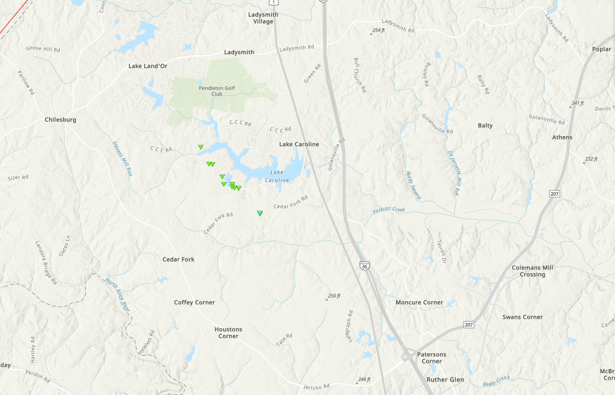 
|
||||||||||||||||
|
Tornado - LOCATION
Track Map 
|
||||||||||||||||
The Enhanced Fujita (EF) Scale classifies tornadoes into the following categories:
| EF0 Weak 65-85 mph |
EF1 Moderate 86-110 mph |
EF2 Significant 111-135 mph |
EF3 Severe 136-165 mph |
EF4 Extreme 166-200 mph |
EF5 Catastrophic 200+ mph |
 |
|||||
Flooding
Hydrographs
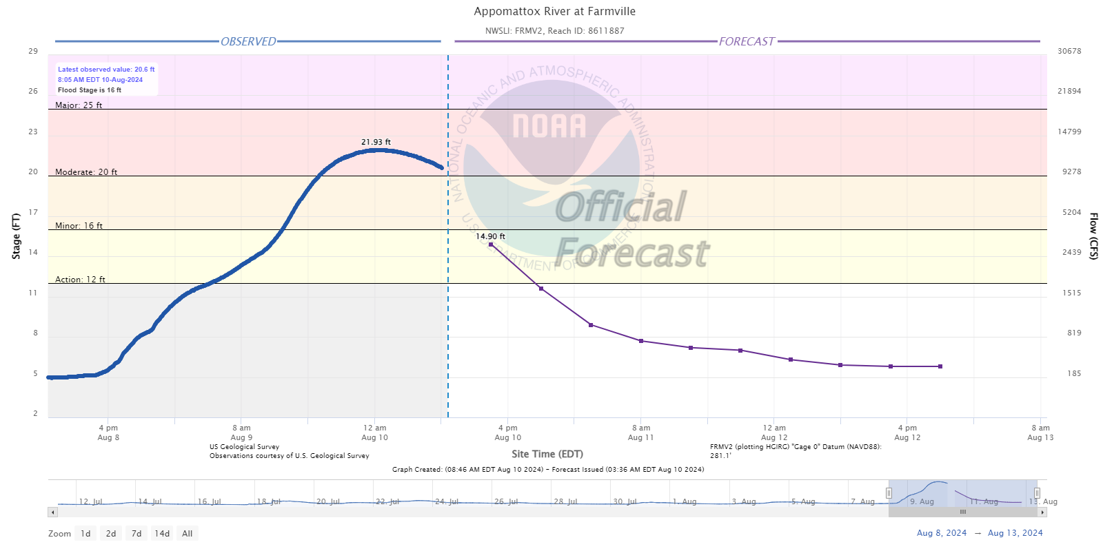 |
.png) |
.png) |
| Appomattox River near Farmville, VA | Chesapeake Bay at Bishop's Head, MD | Chesapeake Bay at Cambridge, MD |
More Hydrographs
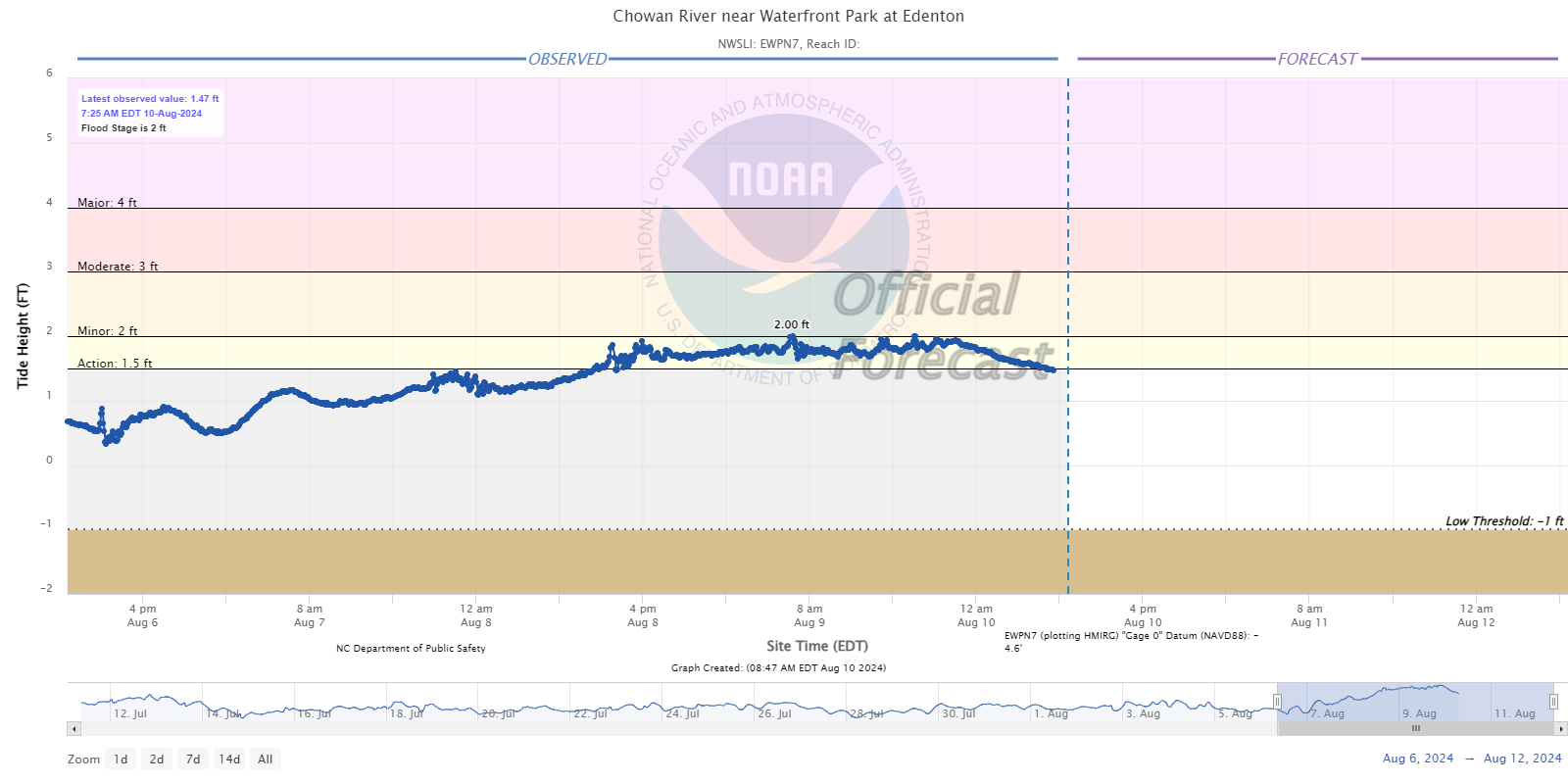 |
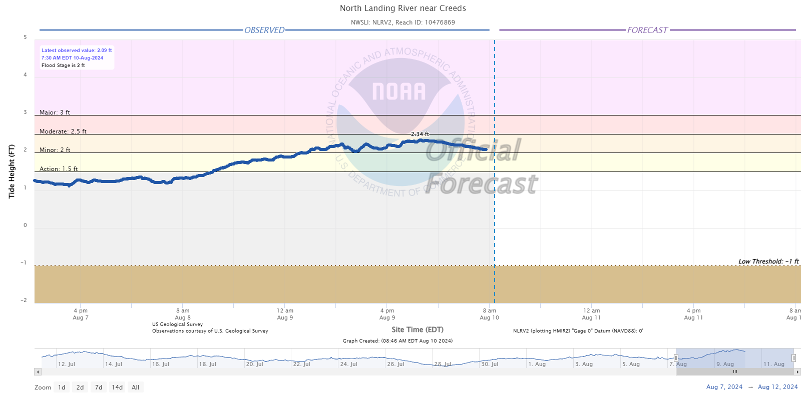 |
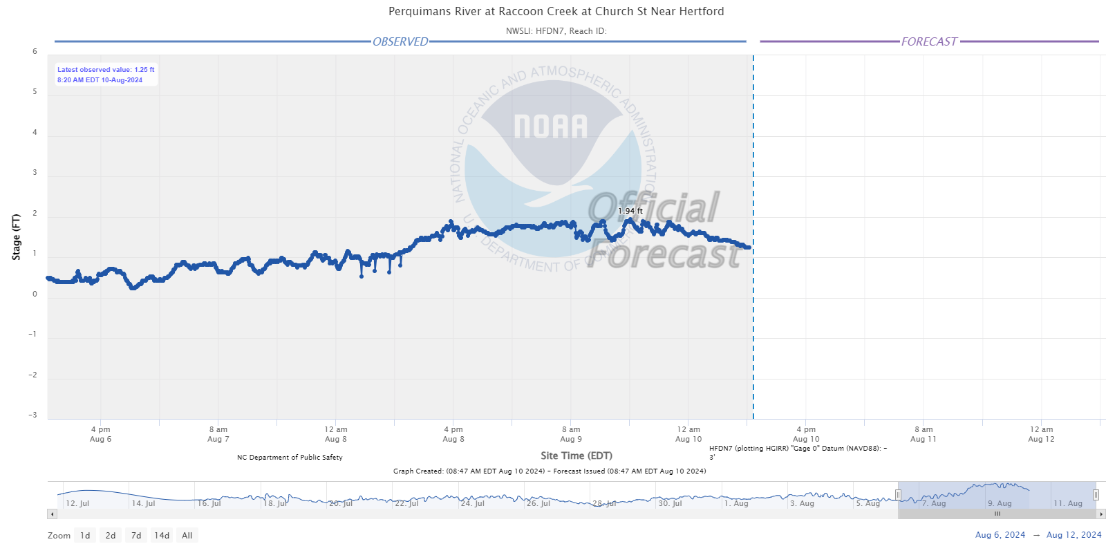 |
| Edenton, NC | Creeds, VA (Back Bay area of VA Beach) | Hertford, NC |
Photos & Video
Radar
 |
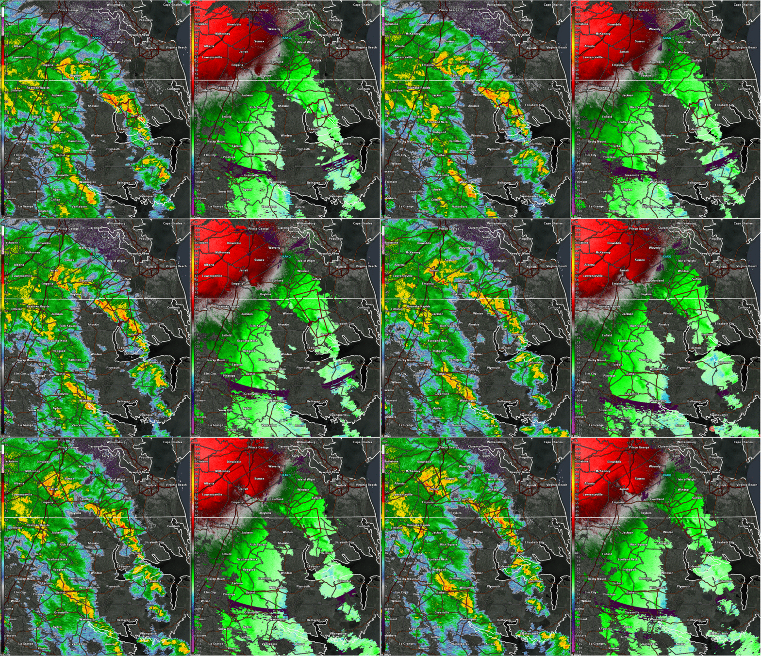 |
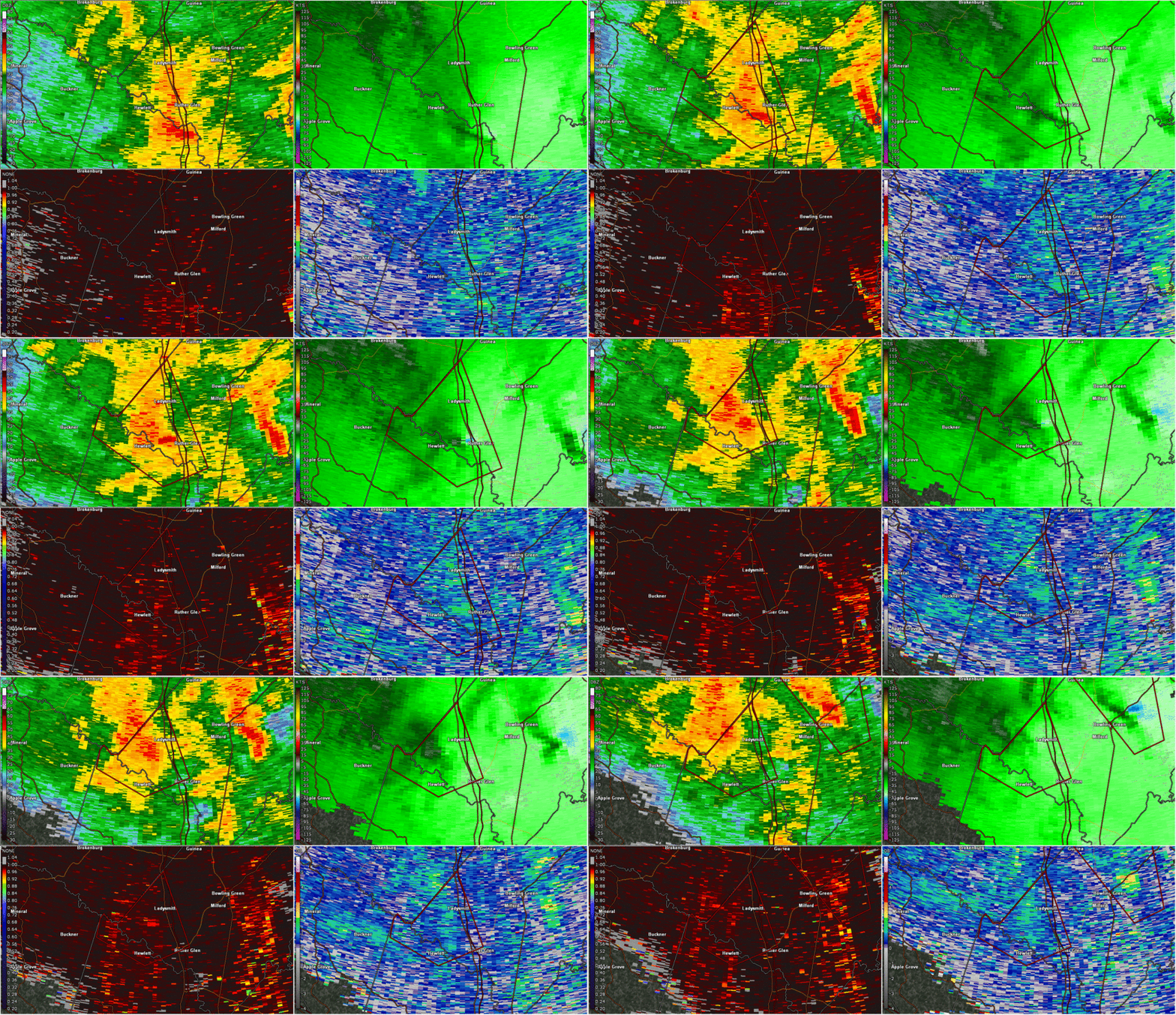
| LWX Radar Loop from 630-705pm (around time of Lake Caroline Tornado) | AKQ Radar Loop from 130-2pm w/ Tornado Warnings |
 |
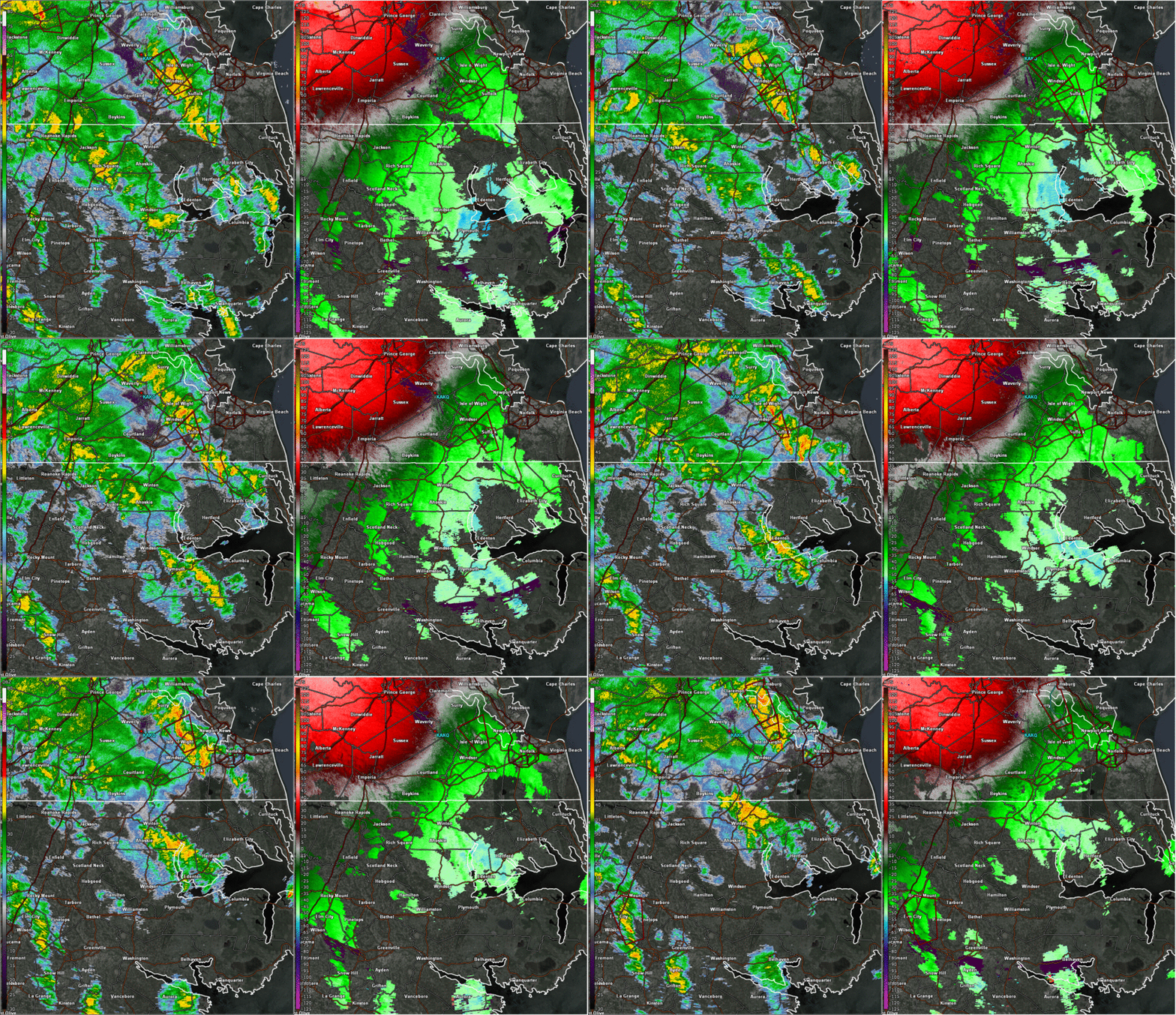 |
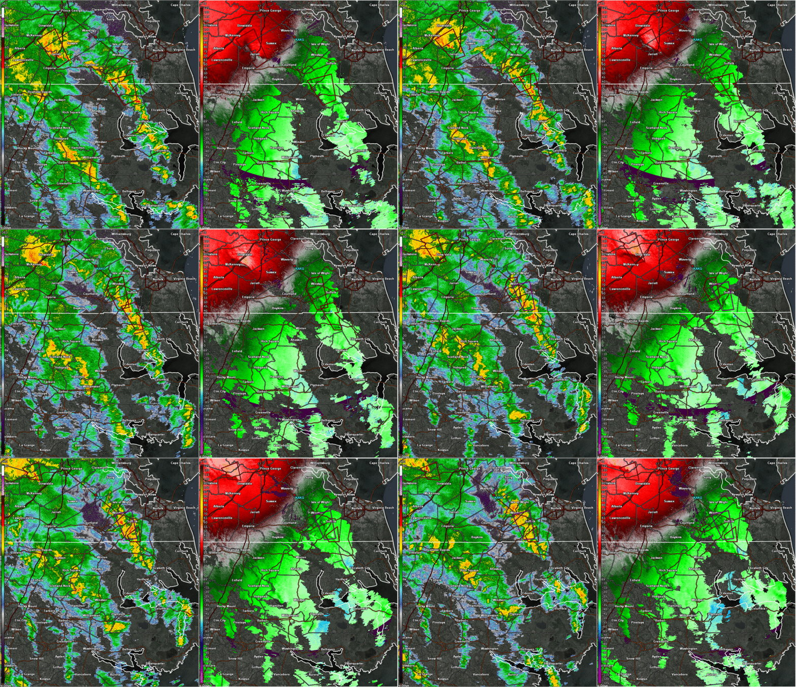
| AKQ Radar Loop from 2-3pm w/ Tornado Warnings | AKQ Radar Loop from 3-415pm w/ Tornado Warnings |
Rain Reports---Scroll to bottom for Rainfall Map
Public Information Statement
National Weather Service Wakefield VA
826 PM EDT Fri Aug 9 2024

...TROPICAL CYCLONE DEBBY EVENT PRECIPITATION REPORTS...

Location                     Amount    Time/Date       Lat/Lon

...Maryland...

...Dorchester County...
Cambridge                    0.44 in   0800 PM 08/09   38.58N/76.09W
Toddville                    0.43 in   0810 PM 08/09   38.31N/76.08W
Blackwater                   0.30 in   0755 PM 08/09   38.45N/76.09W

...Somerset County...
Princess Anne                0.53 in   0807 PM 08/09   38.20N/75.69W

...Wicomico County...
Delmar 0.2 NE                1.14 in   0518 PM 08/09   38.45N/75.57W
Salisbury                    1.12 in   0800 PM 08/09   38.37N/75.66W
Powellville                  0.30 in   0748 PM 08/09   38.36N/75.43W

...Worcester County...
Ocean Pines                  0.41 in   0805 PM 08/09   38.37N/75.14W

...North Carolina...

...Bertie County...
Greens Cross                 2.51 in   0717 PM 08/09   36.02N/76.89W
3.1 E Windsor                0.81 in   0717 PM 08/09   36.02N/76.89W

...Camden County...
South Mills                  1.42 in   0730 PM 08/09   36.44N/76.33W

...Chowan County...
1 NNE Rockyhock              3.46 in   0810 PM 08/09   36.20N/76.69W
Edenton                      3.14 in   0810 PM 08/09   36.02N/76.57W

...Currituck County...
3 SSE Northwest              2.24 in   0810 PM 08/09   36.52N/76.18W

...Hertford County...
Ahoskie Tri Coun             0.88 in   0805 PM 08/09   36.28N/77.17W

...Northampton County...
Henrico                      2.12 in   0800 PM 08/09   36.54N/77.86W
Nc Fire Raws No. 6           2.04 in   0718 PM 08/09   36.41N/77.34W

...Pasquotank County...
Elizabeth City               3.12 in   0713 PM 08/09   36.35N/76.28W
Elizabeth City               2.25 in   0802 PM 08/09   36.30N/76.27W
Elizabeth City Airport       1.89 in   0808 PM 08/09   36.27N/76.18W
Elizabeth City               0.61 in   0725 PM 08/09   36.30N/76.22W

...Perquimans County...
Hertford                     3.51 in   0800 PM 08/09   36.11N/76.43W
Hertford                     2.81 in   0800 PM 08/09   36.10N/76.40W

...Virginia...

...Accomack County...
Wallops Island               0.47 in   0754 PM 08/09   37.93N/75.47W
Tasley 0.5 SW                0.40 in   0830 AM 08/09   37.71N/75.71W
Melfa Accomack               0.35 in   0815 PM 08/09   37.63N/75.77W

...Amelia County...
Amelia Courthouse            1.46 in   0815 PM 08/09   37.34N/77.98W

...Brunswick County...
Ebony                        3.12 in   0807 PM 08/09   36.55N/78.03W
South Hill Meckl             2.17 in   0755 PM 08/09   36.68N/78.03W
Lawrenceville                1.20 in   0755 PM 08/09   36.78N/77.80W

...Caroline County...
Fort Walker_north1           3.31 in   0806 PM 08/09   38.19N/77.30W
Fort Walker_qd 1             2.82 in   0807 PM 08/09   38.07N/77.32W
Ruther Glen                  1.64 in   0810 PM 08/09   38.00N/77.52W

...Chesterfield County...
Chester 1.9 SSE              2.34 in   0441 PM 08/09   37.33N/77.42W
5 NNE Winterpock             1.34 in   0310 PM 08/09   37.41N/77.68W
CHESTERFIELD                 1.31 in   0803 PM 08/09   37.34N/77.64W
Chesterfield                 1.28 in   0810 PM 08/09   37.34N/77.64W
Winterpock                   1.26 in   0800 PM 08/09   37.34N/77.64W
Richmond 6.4 W               1.24 in   0500 PM 08/09   37.52N/77.59W
Chesterfield                 1.08 in   0800 PM 08/09   37.38N/77.71W
Bensley 4.9 WSW              0.96 in   0830 AM 08/09   37.42N/77.53W
Chesterfield                 0.92 in   0800 PM 08/09   37.32N/77.49W
Midlothian                   0.90 in   0810 PM 08/09   37.55N/77.66W
Matoaca                      0.85 in   0805 PM 08/09   37.29N/77.48W
Chesterfield                 0.72 in   0809 PM 08/09   37.34N/77.65W
4 NW Beach                   0.72 in   0815 PM 08/09   37.45N/77.64W
Bon Air                      0.68 in   0805 PM 08/09   37.52N/77.56W
Midlothian                   0.58 in   0807 PM 08/09   37.43N/77.64W
Richmond Chester             0.52 in   0756 PM 08/09   37.40N/77.52W

...City of Chesapeake County...
Fentress Naval               2.71 in   0756 PM 08/09   36.70N/76.13W
Chesapeake                   2.59 in   0800 PM 08/09   36.78N/76.26W
Greenbrier                   2.12 in   0815 PM 08/09   36.79N/76.22W
Chesapeake                   1.78 in   0800 PM 08/09   36.69N/76.21W
Chesapeake                   1.39 in   0757 PM 08/09   36.67N/76.30W
Chesapeake                   1.38 in   0800 PM 08/09   36.83N/76.40W
3 SSW Deep Creek             1.23 in   0810 PM 08/09   36.70N/76.36W
8.0 SW Chesapeake Airport    1.19 in   0730 PM 08/09   36.59N/76.44W
Chesapeake                   1.16 in   0810 PM 08/09   36.73N/76.34W
Deep Creek                   1.01 in   0730 PM 08/09   36.75N/76.34W
Chesapeake                   0.62 in   0755 PM 08/09   36.67N/76.32W
Chesapeake                   0.59 in   0806 PM 08/09   36.70N/76.21W

...City of Colonial Heights County...
Colonial Heights 0.3 ENE     1.43 in   0830 AM 08/09   37.27N/77.39W

...City of Franklin County...
Franklin 1.2 NW              2.81 in   0900 AM 08/09   36.69N/76.95W

...City of Hopewell County...
1 NE Hopewell                0.94 in   0815 PM 08/09   37.30N/77.29W

...City of Newport News County...
Newport News                 1.65 in   0754 PM 08/09   37.13N/76.50W
1 NW Menchville              1.47 in   0814 PM 08/09   37.11N/76.54W
Ft Eustis Felker             1.28 in   0755 PM 08/09   37.13N/76.62W
Ft Eustis Felker             0.49 in   0555 PM 08/09   37.13N/76.62W

...City of Norfolk County...
NORFOLK                      2.23 in   0810 PM 08/09   36.88N/76.25W
Norfolk NAS Cham             1.99 in   0759 PM 08/09   36.92N/76.27W
Norfolk                      1.87 in   0800 PM 08/09   36.89N/76.26W
Norfolk Intl Airport         1.25 in   0759 PM 08/09   36.90N/76.20W

...City of Portsmouth County...
Portsmouth                   1.25 in   0757 PM 08/09   36.80N/76.33W

...City of Richmond County...
Richmond                     0.75 in   0800 PM 08/09   37.57N/77.54W
2 E Bon Air                  0.68 in   0815 PM 08/09   37.51N/77.53W
Richmond 1.1 SE              0.65 in   0845 AM 08/09   37.52N/77.46W
2 SW Downtown Richmond       0.57 in   0815 PM 08/09   37.51N/77.50W

...City of Suffolk County...
Gdr                          1.97 in   0754 PM 08/09   36.61N/76.55W
Suffolk                      1.75 in   0755 PM 08/09   36.68N/76.60W
Suffolk 6.3 N                1.75 in   1000 AM 08/09   36.79N/76.66W
2.2 SE Saunders              0.83 in   0754 PM 08/09   36.61N/76.55W

...City of Virginia Beach County...
Back Bay                     2.88 in   0754 PM 08/09   36.67N/75.92W
Virginia Beach               2.33 in   0810 PM 08/09   36.75N/75.99W
Virginia Beach               2.32 in   0810 PM 08/09   36.77N/76.04W
VIRGINIA BEACH               2.30 in   0806 PM 08/09   36.65N/76.10W
Virginia Beach               2.02 in   0800 PM 08/09   36.76N/76.15W
Virginia Beach               1.92 in   0800 PM 08/09   36.82N/76.20W
Princess Anne Plaz           1.36 in   0815 PM 08/09   36.83N/76.09W
Virginia Beach               1.35 in   0809 PM 08/09   36.86N/76.04W
Virginia Beach               1.24 in   0809 PM 08/09   36.84N/76.06W
Oceana NAS Souce             1.10 in   0756 PM 08/09   36.82N/76.02W
Virginia Beach               0.46 in   0809 PM 08/09   36.81N/76.14W
Virginia Beach               0.42 in   0806 PM 08/09   36.78N/76.14W

...Cumberland County...
Farmville                    2.88 in   0155 PM 08/09   37.35N/78.42W

...Dinwiddie County...
Churchroad                   1.47 in   0800 PM 08/09   37.13N/77.69W
Petersburg                   0.90 in   0815 PM 08/09   37.17N/77.52W

...Essex County...
Dunnsville                   1.37 in   0808 PM 08/09   37.89N/76.81W
Tappahannock                 1.19 in   0815 PM 08/09   37.87N/76.90W

...Fluvanna County...
SCOTTSVILLE                  3.11 in   0805 PM 08/09   37.80N/78.46W
Palmyra                      2.03 in   0810 PM 08/09   37.85N/78.36W
Troy                         1.06 in   0805 PM 08/09   37.94N/78.29W
Scottsville                  0.67 in   0810 PM 08/09   37.74N/78.40W

...Gloucester County...
Hayes                        0.86 in   0809 PM 08/09   37.27N/76.49W
Hayes                        0.63 in   0805 PM 08/09   37.27N/76.43W
Gloucester Courthouse 0.7 NN 0.54 in   0830 AM 08/09   37.42N/76.53W

...Goochland County...
Maidens                      0.90 in   0800 PM 08/09   37.70N/77.81W
Manakin Sabot                0.38 in   0800 PM 08/09   37.62N/77.74W
1 N Fife                     0.35 in   0815 PM 08/09   37.76N/78.06W

...Greensville County...
Purdy                        1.33 in   0805 PM 08/09   36.79N/77.57W
Emporia                      0.80 in   0815 PM 08/09   36.68N/77.48W

...Hanover County...
Mechanicsville               1.47 in   0809 PM 08/09   37.58N/77.30W
Ashland                      1.27 in   0800 PM 08/09   37.75N/77.48W
Ashland                      1.18 in   0815 PM 08/09   37.76N/77.48W
Mechanicsville               1.05 in   0807 PM 08/09   37.60N/77.33W
Richmond Hanover             0.51 in   0754 PM 08/09   37.70N/77.43W

...Henrico County...
Richmond                     1.41 in   0800 PM 08/09   37.63N/77.63W
Henrico 4.1 W                1.39 in   0900 AM 08/09   37.63N/77.62W
Henrico 5.8 W                1.32 in   0830 AM 08/09   37.64N/77.65W
Highland Springs 8.1 SE      1.14 in   0830 AM 08/09   37.48N/77.21W
Henrico                      1.10 in   0810 PM 08/09   37.47N/77.28W
Richmond Intl Airport        1.09 in   0754 PM 08/09   37.52N/77.32W
Richmond                     1.05 in   0800 PM 08/09   37.46N/77.35W
Tuckahoe                     0.96 in   0815 PM 08/09   37.58N/77.59W
2 SSW Short Pump             0.93 in   1148 AM 08/09   37.61N/77.62W
Richmond                     0.90 in   0810 PM 08/09   37.60N/77.58W
Richmond                     0.83 in   0809 PM 08/09   37.64N/77.65W
GLEN ALLEN                   0.66 in   0806 PM 08/09   37.68N/77.59W
Glen Allen                   0.60 in   0810 PM 08/09   37.69N/77.59W
Glen Allen                   0.57 in   0805 PM 08/09   37.66N/77.50W
1 NW Lakeside                0.40 in   0815 PM 08/09   37.63N/77.48W
Glen Allen                   0.31 in   0710 PM 08/09   37.66N/77.57W

...Isle of Wight County...
Franklin J B Ros             1.03 in   0755 PM 08/09   36.70N/76.90W

...James City County...
Williamsburg 4.5 NW          1.54 in   0900 AM 08/09   37.31N/76.78W
Williamsburg                 1.47 in   0807 PM 08/09   37.25N/76.80W
Fords Colony                 1.42 in   0808 PM 08/09   37.30N/76.75W
York River State Park        0.69 in   0730 PM 08/09   37.41N/76.71W
Toano                        0.35 in   0810 PM 08/09   37.44N/76.82W

...King William County...
WEST POINT                   0.85 in   0810 PM 08/09   37.56N/76.80W
Aylett 4.4 WSW               0.80 in   0900 AM 08/09   37.75N/77.17W

...King and Queen County...
West Point                   0.84 in   0755 PM 08/09   37.52N/76.77W

...Lancaster County...
Mollusk                      0.87 in   0600 PM 08/09   37.71N/76.53W

...Louisa County...
Troy                         1.43 in   0806 PM 08/09   38.00N/78.24W
Troy                         1.42 in   0800 PM 08/09   38.01N/78.25W
Louisa                       0.96 in   0755 PM 08/09   38.02N/77.97W
Louisa                       0.94 in   0800 PM 08/09   38.04N/78.01W
Mineral                      0.84 in   0805 PM 08/09   38.00N/77.91W
1 SE Green Springs           0.68 in   0815 PM 08/09   38.08N/78.10W
Bumpass                      0.52 in   0755 PM 08/09   37.97N/77.75W
Mineral                      0.50 in   0815 PM 08/09   38.02N/77.92W
Bumpass                      0.49 in   0655 PM 08/09   37.97N/77.75W

...Lunenburg County...
2 WSW Kenbridge              1.64 in   0805 PM 08/09   36.95N/78.17W
Kenbridge                    1.60 in   0755 PM 08/09   36.95N/78.18W

...Mathews County...
North                        0.87 in   0800 PM 08/09   37.45N/76.45W

...Mecklenburg County...
1 E Boydton                  3.41 in   0810 PM 08/09   36.66N/78.37W
2 NE Boydton                 3.21 in   0810 PM 08/09   36.69N/78.37W
Boydton                      3.19 in   0808 PM 08/09   36.73N/78.36W
1 NE Boydton                 2.94 in   0813 PM 08/09   36.68N/78.38W
Chase City                   2.62 in   0755 PM 08/09   36.78N/78.50W
John H Kerr Dam              1.23 in   0715 PM 08/09   36.60N/78.30W

...Middlesex County...
Hartfield                    1.57 in   0806 PM 08/09   37.56N/76.51W
1 S Deltaville               0.99 in   0810 PM 08/09   37.53N/76.33W
Remlik                       0.68 in   0800 PM 08/09   37.68N/76.62W
Saluda                       0.68 in   0755 PM 08/09   37.60N/76.45W
Urbanna                      0.58 in   0806 PM 08/09   37.66N/76.60W
Stingray Point               0.34 in   0810 PM 08/09   37.55N/76.30W

...New Kent County...
Quinton                      0.70 in   0755 PM 08/09   37.50N/77.12W

...Northampton County...
UVA COAST CTR CAPE CHARLES 5 3.71 in   0800 PM 08/09   37.29N/75.93W

...Northumberland County...
Heathsville                  0.56 in   0805 PM 08/09   37.87N/76.42W
Reedville                    0.54 in   0800 PM 08/09   37.88N/76.25W
Heathsville                  0.50 in   0800 PM 08/09   37.93N/76.32W

...Nottoway County...
Blackstone Fort              1.40 in   0755 PM 08/09   37.07N/77.95W
Blackstone                   1.36 in   0810 PM 08/09   37.07N/78.00W
Crewe                        1.17 in   0755 PM 08/09   37.18N/78.10W

...Powhatan County...
Powhatan                     1.11 in   0805 PM 08/09   37.59N/77.79W

...Prince Edward County...
Green Bay                    2.62 in   0808 PM 08/09   37.13N/78.31W
Farmville 0.5 E              2.48 in   0830 AM 08/09   37.30N/78.39W
Farmville                    1.65 in   0814 PM 08/09   37.30N/78.39W

...Prince George County...
1 ESE Disputanta             1.15 in   0810 PM 08/09   37.11N/77.20W
James River                  1.10 in   0751 PM 08/09   37.26N/77.14W
2 WSW Garysville             0.96 in   0815 PM 08/09   37.23N/77.20W

...Sussex County...
1 NW Wakefield               0.81 in   0654 PM 08/09   36.98N/77.00W
1 NW Wakefield               0.60 in   0754 PM 08/09   36.98N/77.00W

...Westmoreland County...
MONTROSS                     0.73 in   0800 PM 08/09   38.09N/76.81W
Montross                     0.51 in   0815 PM 08/09   38.10N/76.83W

...York County...
Williamsburg                 1.16 in   0800 PM 08/09   37.35N/76.70W
Newport News 7.2 NE          1.00 in   1042 AM 08/09   37.16N/76.43W
Seaford                      0.71 in   0801 PM 08/09   37.19N/76.43W
&&
Environment
Synoptic summary.
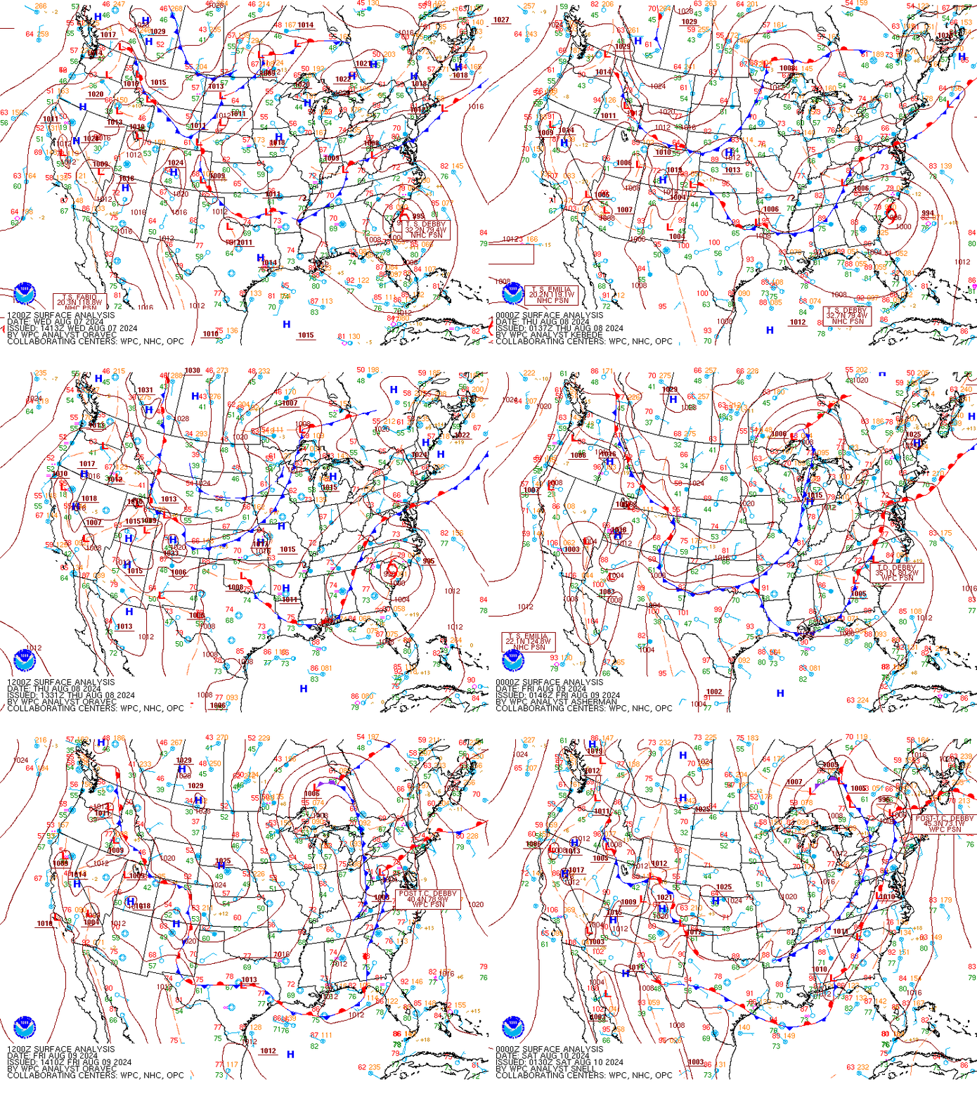 |
| Loop of WPC Surface Maps from 8/7 to 8/9 in 3-h Increments |
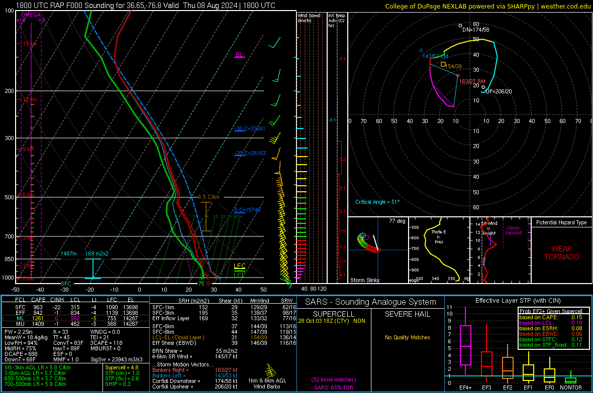
Additional environmental data.
 |
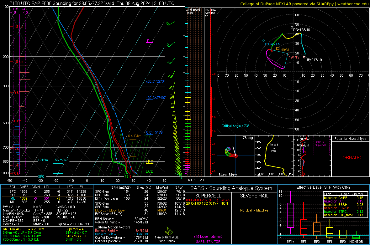 |
| 18z/2 PM RAP Sounding from Suffolk, VA | 21z/5 PM RAP Sounding from Caroline County, VA |
 |
Media use of NWS Web News Stories is encouraged! Please acknowledge the NWS as the source of any news information accessed from this site. |
 |