Overview
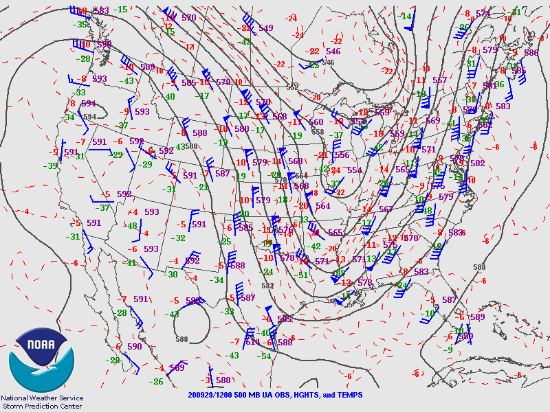
On the morning of September 29th, a deep upper trough extended from the Hudson Bay all the way the the western Gulf coast. A potent shortwave was situated over the middle Mississippi River Valley. At the surface, strong low pressure was located over eastern Canada with the associated cold front extending south into the mountains of VA/NC and all the way down the Gulf of America. The front would remain to the west of the AKQ CWA until ~6 PM. Ahead of the front, deep moisture was streaming into the area from the south (especially east of I-95). Scattered to numerous showers and thunderstorms continued throughout the day across eastern VA, NE NC, and the Lower Eastern Shore. Locally, some areas received 1-2" during the day on the 29th. However, no severe weather was observed during the day (low-level wind fields were relatively modest and instability was held in check due to warm mid-levels/cloud cover). From the evening of the 29th through the early morning on the 30th, the cold front crossed the region while a secondary area of low pressure deepened as it tracked NNE (along the front) through the Mid-Atlantic region. Ahead of the front, a south-southwesterly low-level jet strengthened to 40-50 knots from far SE VA to eastern NC. Combined with SSE winds and low-mid 70s dew points (enough for limited surface-based instability) ahead of the front in SE VA/NE NC, there was enough speed and directional shear for effective SRH values to climb to 100-250 m2/s2 by mid-late evening. A narrow line of shallow convection (w/ little to no thunder) traversed the area from W-E with the front during the evening. While wind gusts with the line were sub-severe, two brief EF-0 tornadoes were observed from 1030-1115 PM: one in Southampton County and another in Isle of Wight County.
Tornadoes:
|
Tornado - Black Creek Road/Burdette
Track Map 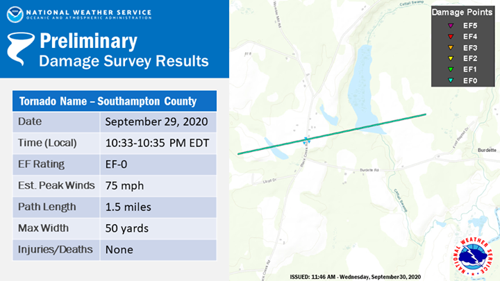 
|
||||||||||||||||
|
Tornado - Five Forks Road to Orbit Road
Track Map 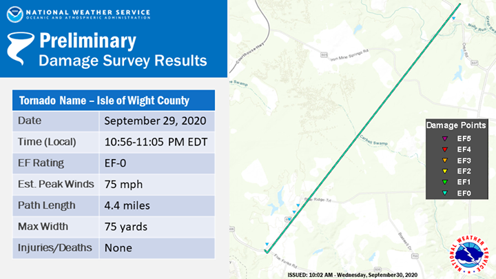
|
||||||||||||||||
The Enhanced Fujita (EF) Scale classifies tornadoes into the following categories:
| EF0 Weak 65-85 mph |
EF1 Moderate 86-110 mph |
EF2 Significant 111-135 mph |
EF3 Severe 136-165 mph |
EF4 Extreme 166-200 mph |
EF5 Catastrophic 200+ mph |
 |
|||||
Radar
Radar Loop
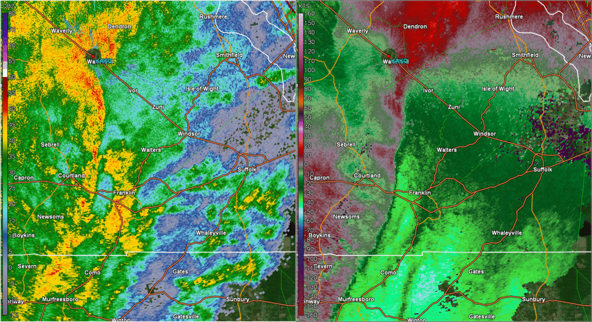 |
| Radar loop of 0.5° Reflectivity (left) and Base Velocity (right) from ~1025 PM-1115 PM. Note that the circulations which resulted in the two tornadoes were very transient (strengthening/weakening in a matter of minutes). |
Rainfall Reports
Public Information Statement
National Weather Service Wakefield VA
1039 AM EDT Wed Sep 30 2020

...PRECIPITATION REPORTS...

Location                     Amount    Time/Date       Provider

...Maryland...

...Dorchester County...
Toddville                    2.63 in   0745 AM 09/30   CWOP
East New Market 1.9 SE       2.12 in   0400 AM 09/30   COCORAHS
East New Market 0.0 WNW      2.06 in   0700 AM 09/30   COCORAHS

...Somerset County...
Princess Anne                2.76 in   0752 AM 09/30   CWOP
1.0 NE Princess Anne         2.75 in   0800 AM 09/30   COOP
Crisfield 0.9 ENE            2.22 in   0830 AM 09/30   COCORAHS

...Wicomico County...
Salisbury                    2.68 in   0753 AM 09/30   CWOP
Delmar 0.2 NE                2.63 in   0703 AM 09/30   COCORAHS
Salisbury                    2.52 in   0853 AM 09/30   CWOP
Fruitland 1.8 ENE            2.36 in   0700 AM 09/30   COCORAHS
Mardela Springs              2.21 in   0755 AM 09/30   AWS

...North Carolina...

...Chowan County...
Edenton 0.4 NW               2.05 in   0700 AM 09/30   COCORAHS

...Virginia...

...Chesterfield County...
Matoaca                      2.22 in   0751 AM 09/30   CWOP

...City of Williamsburg County...
Williamsburg 1.4 ENE         3.26 in   0700 AM 09/30   COCORAHS
Williamsburg 1.0 SSW         3.11 in   0645 AM 09/30   COCORAHS
Williamsburg 1.3 SSW         2.88 in   0630 AM 09/30   COCORAHS

...Gloucester County...
Gloucester Courthouse 3.3 SS 3.10 in   0800 AM 09/30   COCORAHS
Gloucester Courthouse 4.2 SS 2.86 in   0742 AM 09/30   COCORAHS
Gloucester Courthouse 2.4 ES 2.11 in   0700 AM 09/30   COCORAHS

...Goochland County...
Tabscott                     2.61 in   0750 AM 09/30   CWOP
Crozier                      2.33 in   0700 AM 09/30   COOP
Kents Store                  2.04 in   0746 AM 09/30   CWOP

...James City County...
Williamsburg 1.6 ESE         3.24 in   0700 AM 09/30   COCORAHS
Williamsburg 1.9 SW          2.74 in   0800 AM 09/30   COCORAHS
Williamsburg 3.2 NW          2.41 in   0800 AM 09/30   COCORAHS
Williamsburg 3.7 SW          2.32 in   0700 AM 09/30   COCORAHS
Williamsburg 2.6 WSW         2.30 in   0900 AM 09/30   COCORAHS
Williamsburg 4.7 WSW         2.21 in   0700 AM 09/30   COCORAHS
Williamsburg 3.8 WSW         2.19 in   0700 AM 09/30   COCORAHS
Williamsburg 4.1 WNW         2.17 in   0700 AM 09/30   COCORAHS
Williamsburg 3.2 WNW         2.13 in   0700 AM 09/30   COCORAHS

...Lancaster County...
Kilmarnock                   2.49 in   0755 AM 09/30   AWS

...Middlesex County...
Saluda                       3.42 in   0755 AM 09/30   AWOS
Hartfield                    3.37 in   0751 AM 09/30   CWOP
Locust Hill 1.1 ENE          2.75 in   0700 AM 09/30   COCORAHS

...Northumberland County...
Heathsville 4.6 SE           2.47 in   0700 AM 09/30   COCORAHS
Heathsville                  2.10 in   0747 AM 09/30   CWOP

...Southampton County...
Sedley 3.7 N                 2.66 in   0700 AM 09/30   COCORAHS
Drewryville 2.3 SW           2.61 in   0654 AM 09/30   COCORAHS

...Sussex County...
1.5 NW Wakefield             2.26 in   1200 AM 09/30   COOP
Norfolk Wakefld              2.23 in   0754 AM 09/30   ASOS

...York County...
Williamsburg                 2.89 in   0753 AM 09/30   CWOP
Williamsburg 6.0 N           2.38 in   0800 AM 09/30   COCORAHS
Williamsburg                 2.25 in   0745 AM 09/30   CWOP
Newport News 7.5 NNE         2.06 in   0717 AM 09/30   COCORAHS

&&
Environment
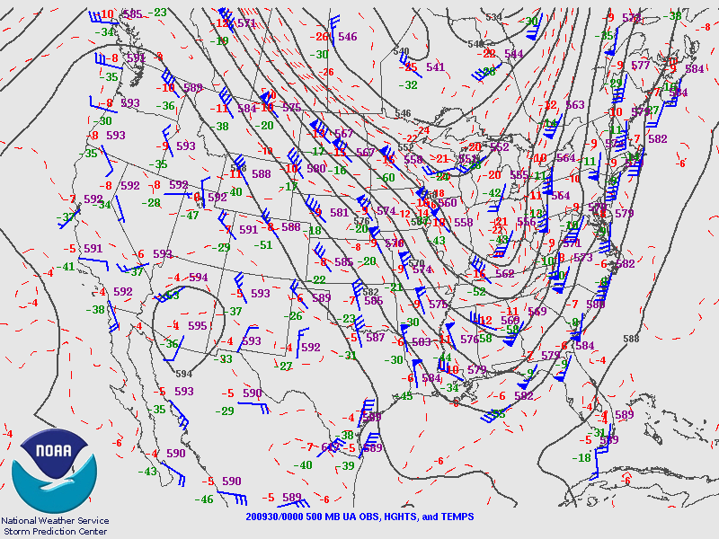
Synoptic upper air summary.
 |
 |
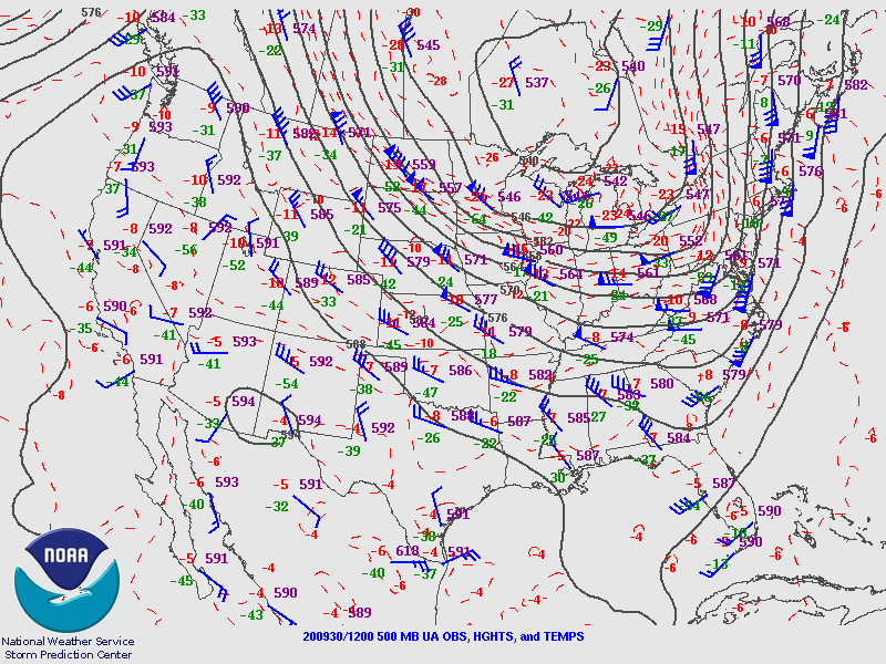 |
| 9/29 8 AM 500 mb Analysis | 9/29 8 PM 500 mb Analysis | 9/30 8 AM 500 mb Analysis |
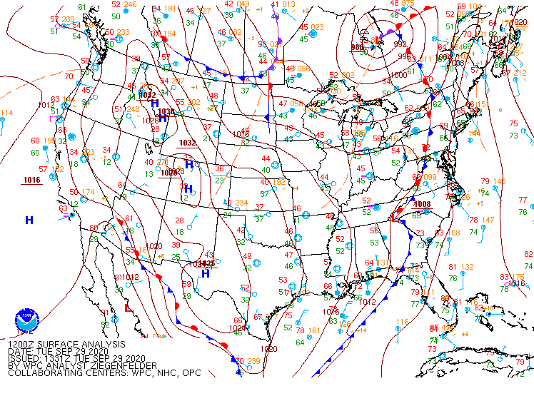
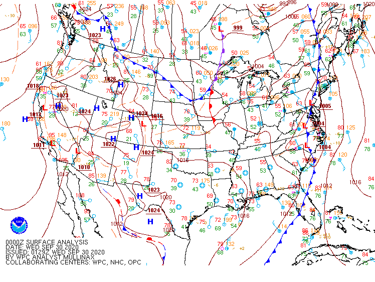
Synoptic surface summary.
 |
 |
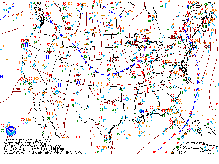 |
| 9/29 8 AM WPC Surface Analysis | 9/29 8 PM WPC Surface Analysis | 9/30 8 AM WPC Surface Analysis |
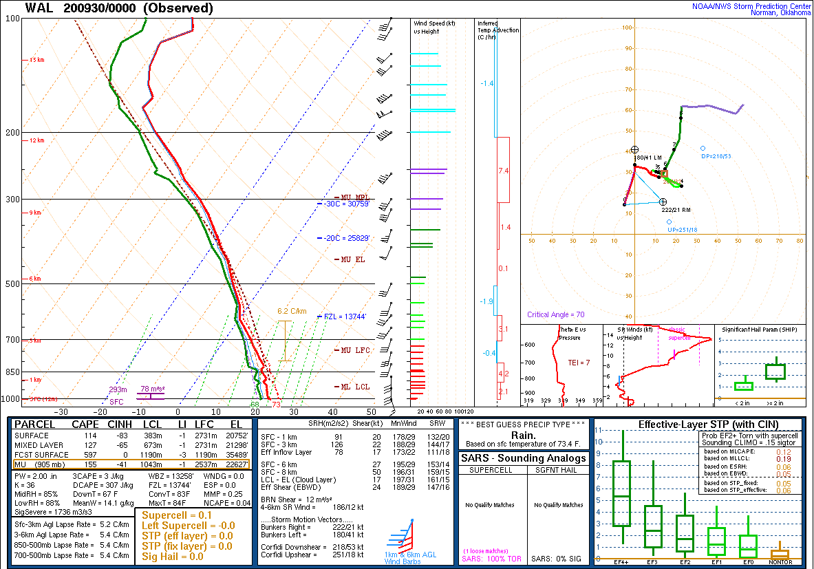
Environmental sounding data.
 |
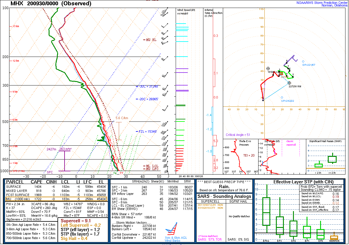 |
| 00z 9/30 (8 PM EDT 9/29) Observed Sounding from WAL (Wallops Island, VA) | 00z 9/30 (8 PM EDT 9/29 Observed Sounding from MHX) |
 |
Media use of NWS Web News Stories is encouraged! Please acknowledge the NWS as the source of any news information accessed from this site. |
|


 Coastal Flood
 Heat
Heat