Key Points (updated 05:00 AM, 5/6/2023)
-
Mississippi River has crested from Lake City to Guttenberg Dam 10. MAJOR level flooding occurred at Wabasha, Winona, Trempealeau, La Crosse, and McGregor.
- ​It will take until around May 10th (a little earlier for northern sites, a little later for southern sites) for most sites to fall below Flood Stage. Another week from there for the river to fall back within its banks.
- The river was at its highest since 2001. - Most sites saw a top 5 crest.
-
Do not enter flooded waters - hidden debris that the flood has picked up along the way can cause serious injury and/or trap you under the water with strong currents.
-
Adjustments to official river forecasts (the purple line on the graphs below under "Latest Stages / 7 Day Forecasts") will be made at least twice per day in the AM & PM. Reference the official forecasts often and use them as a guide to help your planning - they take into account additional rainfall and how the snowmelt has been progressing.
Current Stages & 7-Day Forecasts
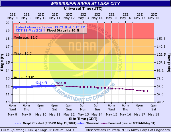
| Lake City [more details] |
 |
| Flood Categories |
| Major Flood: |
20 ft |
| Moderate Flood: |
18 ft |
| Flood Stage: |
16 ft |
| Action Stage: |
14 ft |
| Historical Crests: |
- 22.18 ft on 04/19/1965
- 20.20 ft on 04/17/1969
- 20.13 ft on 04/16/2001
- 19.17 ft on 04/18/1952
- 19.06 ft on 04/16/1951
|
|
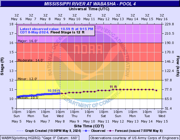
| Wabasha [more details] |
 |
| Flood Categories |
| Major Flood: |
16 ft |
| Moderate Flood: |
14 ft |
| Flood Stage: |
12 ft |
| Action Stage: |
10 ft |
| Historical Crests: |
- 20.05 ft on 04/19/1965
- 18.22 ft on 04/16/2001
- 17.63 ft on 04/16/1969
- 16.71 ft on 04/18/1952
- 16.53 ft on 04/11/1997
|
|
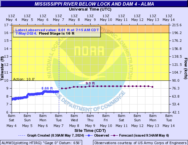
| Alma[more details] |
 |
| Flood Categories |
| Major Flood: |
18 ft |
| Moderate Flood: |
17 ft |
| Flood Stage: |
16 ft |
| Action Stage: |
11 ft |
| Historical Crests: |
- 19.78 ft on 04/19/1965
- 18.15 ft on 04/16/2001
- 17.53 ft on 04/18/1969
- 16.30 ft on 04/18/1952
- 16.20 ft on 04/16/1951
|
|
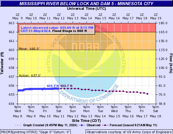
| Minnesota City[more details] |
 |
| Flood Categories |
| Major Flood: |
665 ft |
| Moderate Flood: |
662 ft |
| Flood Stage: |
660 ft |
| Action Stage: |
657 ft |
| Historical Crests: |
- 667.85 ft on 04/19/1965
- 665.70 ft on 04/16/2001
- 665.45 ft on 04/11/1997
- 665.10 ft on 04/18/1969
- 663.84 ft on 04/19/1952
|
|
| Winona Dam 5A [more details] |
 |
| Flood Categories |
| Major Flood: |
661 ft |
| Moderate Flood: |
659 ft |
| Flood Stage: |
655 ft |
| Action Stage: |
650 ft |
| Historical Crests: |
- 663.35 ft on 04/19/1965
- 661.95 ft on 04/17/2001
- 661.60 ft on 04/11/1997
- 661.37 ft on 04/19/1969
- 659.90 ft on 04/20/1952
|
|
| Winona [more details] |
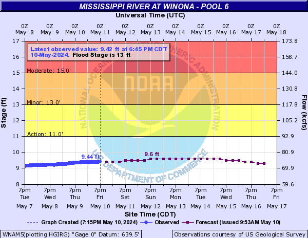 |
| Flood Categories |
| Major Flood: |
18 ft |
| Moderate Flood: |
15 ft |
| Flood Stage: |
13 ft |
| Action Stage: |
11 ft |
| Historical Crests: |
- 20.77 ft on 04/19/1965
- 20.07 ft on 04/17/2001
- 19.44 ft on 04/19/1969
- 18.30 ft on 04/11/1997
- 17.93 ft on 04/20/1952
|
|
| Trempealeau[more details] |
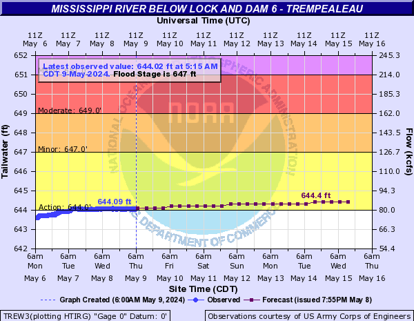 |
| Flood Categories |
| Major Flood: |
651 ft |
| Moderate Flood: |
649 ft |
| Flood Stage: |
647 ft |
| Action Stage: |
644 ft |
| Historical Crests: |
- 653.02 ft on 04/21/1965
- 651.43 ft on 04/18/2001
- 651.40 ft on 04/11/1997
- 650.80 ft on 04/19/1969
- 649.98 ft on 04/20/1952
|
|
| La Crescent [more details] |
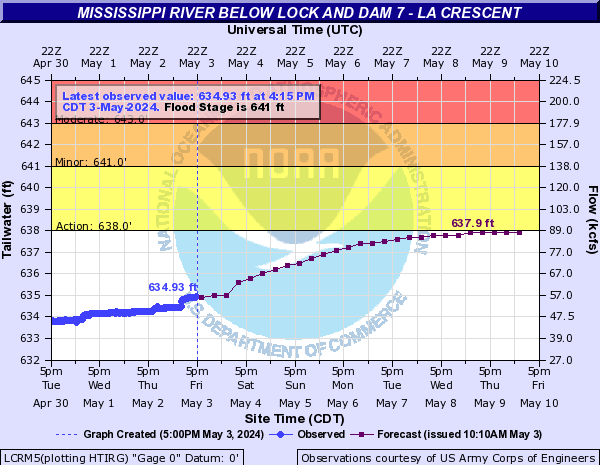 |
| Flood Categories |
| Major Flood: |
645 ft |
| Moderate Flood: |
643 ft |
| Flood Stage: |
641 ft |
| Action Stage: |
638 ft |
| Historical Crests: |
- 647.38 ft on 04/21/1965
- 645.20 ft on 04/18/2001
- 644.87 ft on 04/20/1969
- 644.30 ft on 04/20/1952
- 643.85 ft on 04/19/1951
|
|
| La Crosse [more details] |
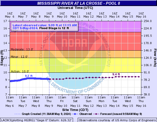 |
| Flood Categories |
| Major Flood: |
15.5 ft |
| Moderate Flood: |
13 ft |
| Flood Stage: |
12 ft |
| Action Stage: |
10 ft |
| Historical Crests: |
- 17.89 ft on 04/22/1965
- 16.41 ft on 04/18/2001
- 15.70 ft on 04/20/1969
- 15.30 ft on 04/20/1952
- 15.01 ft on 04/12/1997
|
|
| Genoa [more details] |
 |
| Flood Categories |
| Major Flood: |
636 ft |
| Moderate Flood: |
634 ft |
| Flood Stage: |
631 ft |
| Action Stage: |
625.2 ft |
| Historical Crests: |
- 638.40 ft on 04/22/1965
- 636.45 ft on 04/12/1997
- 636.21 ft on 04/18/2001
- 635.24 ft on 04/20/1969
- 634.52 ft on 04/20/1952
|
|
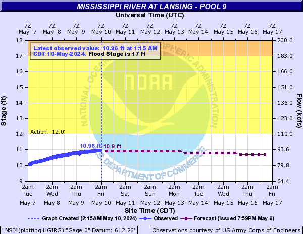
| Lansing [more details] |
 |
| Flood Categories |
| Major Flood: |
20 ft |
| Moderate Flood: |
19 ft |
| Flood Stage: |
17 ft |
| Action Stage: |
12 ft |
| Historical Crests: |
- 22.50 ft on 04/24/1965
- 19.93 ft on 04/21/2001
- 19.90 ft on 06/20/1880
- 18.88 ft on 04/22/1969
- 18.46 ft on 06/30/1993
|
|
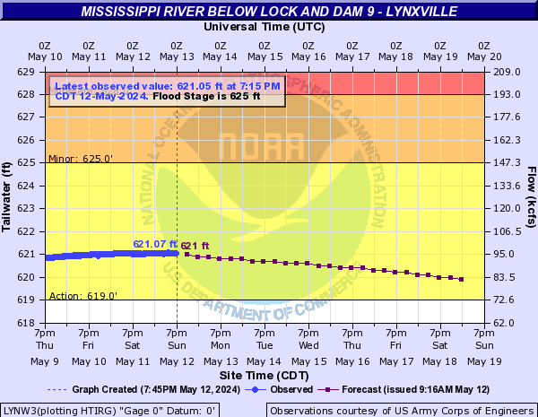
| Lynxville[more details] |
 |
| Flood Categories |
| Major Flood: |
631 ft |
| Moderate Flood: |
628 ft |
| Flood Stage: |
625 ft |
| Action Stage: |
620 ft |
| Historical Crests: |
- 633.16 ft on 04/24/1965
- 631.22 ft on 04/21/2001
- 631.05 ft on 04/14/1997
- 629.42 ft on 04/22/1969
- 629.08 ft on 06/30/1993
|
|
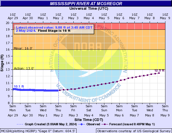
| McGregor [more details] |
 |
| Flood Categories |
| Major Flood: 22 ft |
22 ft |
| Moderate Flood: 19 ft |
19 ft |
| Flood Stage: 16 ft |
16 ft |
| Action Stage: 13 ft |
13 ft |
| Historical Crests: |
- 25.38 ft on 04/24/1965
- 23.75 ft on 04/20/2001
- 21.98 ft on 06/29/1993
- 21.75 ft on 04/26/2019
- 21.58 ft on 04/22/1969
|
|
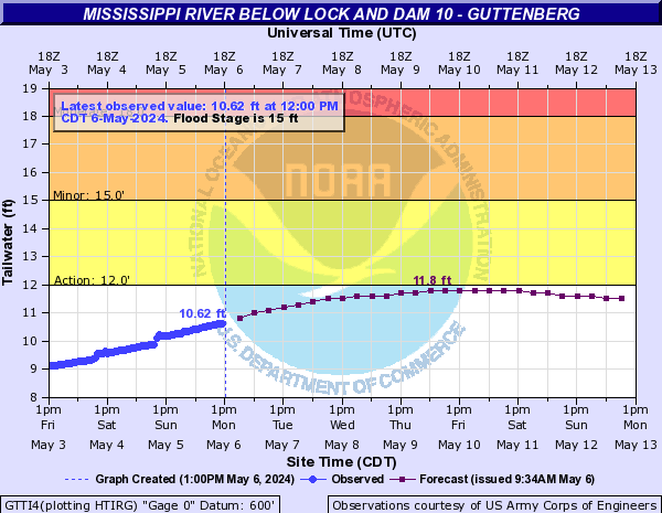
| Guttenberg[more details] |
 |
| Flood Categories |
| Major Flood: 21 ft |
21 ft |
| Moderate Flood: 18 ft |
18 ft |
| Flood Stage: 15 ft |
15 ft |
| Action Stage: 12 ft |
12 ft |
| Historical Crests: |
- 23.65 ft on 04/24/1965
- 21.68 ft on 04/21/2001
- 20.15 ft on 06/30/1993
- 19.98 ft on 04/27/2019
- 19.84 ft on 04/22/1969
|
|
Preliminary Timing & Crests
Flooding this spring produced crests down the mainstem Mississippi River somewhere between 2019 and 2001 flood levels - most of these crests fell
within the top 5 on record.
- The bulk of the snowpack in the Mississippi River basin has melted and this water is working down the river. Additional rises along the Mississippi River will be tied to any future precipitation.
- After the river crests, it will take 2 to 3 weeks for the river to fall back to normal levels. Any precipitation that falls during this sensitive time may result in secondary crests and/or a prolonged period of the river remaining above flood stage.
- The information below (as of May 1) is based on preliminary data and is subject to review and adjustments.*
| Location |
Major
Flood Stage |
Preliminary 2023 Crest |
Crest Timing |
2023 Crest Rank |
2019 Crest |
2001 Crest |
1965 Crest |
| Lake City |
20 ft |
~18.98 ft |
Crested April 25 |
6th |
17.63 ft |
20.13 ft |
22.18 ft |
| Wabasha |
16 ft |
~17.03 ft |
Crested April 25 |
4th |
15.54 ft |
18.22 ft |
20.05 ft |
| Alma |
18 ft |
~17.05 ft |
Crested April 25 |
4th |
15.50 ft |
18.15 ft |
19.78 ft |
| MN City Dam |
665 ft |
~664.30 ft |
Crested April 25 |
5th |
662.62 ft |
665.70 ft |
667.85 ft |
| Winona Dam |
661 ft |
~660.51 ft |
Crested April 26 |
5th |
658.75 ft |
661.95 ft |
663.35 ft |
| Winona |
18 ft |
~18.81 ft |
Crested April 26 |
4th |
17.30 ft |
20.07 ft |
20.77 ft |
| Trempealeau |
651 ft |
~651.01 |
Crested April 25 |
4th |
649.80 ft |
651.43 ft |
653.02 ft |
| La Crescent |
645 ft |
~644.77 ft |
Crested April 26 |
4th |
643.9 ft |
645.20 ft |
647.38 ft |
| La Crosse |
15.5 ft |
~15.89 ft |
Crested April 26 |
3rd |
14.58 ft |
16.41 ft |
17.89 ft |
| Genoa |
636 ft |
~635.72 ft |
Crested April 27 |
4th |
633.84 ft |
636.21 ft |
638.40 ft |
| Lansing |
20 ft |
~ 19.61 ft |
Crested April 28 |
4th |
17.89 ft |
19.93 ft |
22.50 ft |
| Lynxville |
631 ft |
~630.26 ft |
Crested April 28 |
4th |
628.74 ft |
631.22 ft |
633.16 ft |
| McGregor |
22 ft |
~ 22.91 ft |
Crested April 28 |
3rd |
21.75 ft |
23.75 ft |
25.38 ft |
| Guttenberg |
21 ft |
~20.98 ft |
Crested April 28 |
3rd |
19.98 ft |
21.68 ft |
23.65 ft |
What do the flood crest categories mean?
- MODERATE: some inundation of roads and structures near the river and/or some evacuations.
- MAJOR: extensive inundation of roads and structures and/or significant evacuation efforts.
Background Information on High Chances of Flooding
Why was flooding likely this year along the Mississippi River? Multiple factors impacted this year's spring flooding potential, but the main driver was the unseasonably deep snowpack across northern parts of the region - coupled with the rapid warm-up that led to rapid melting.
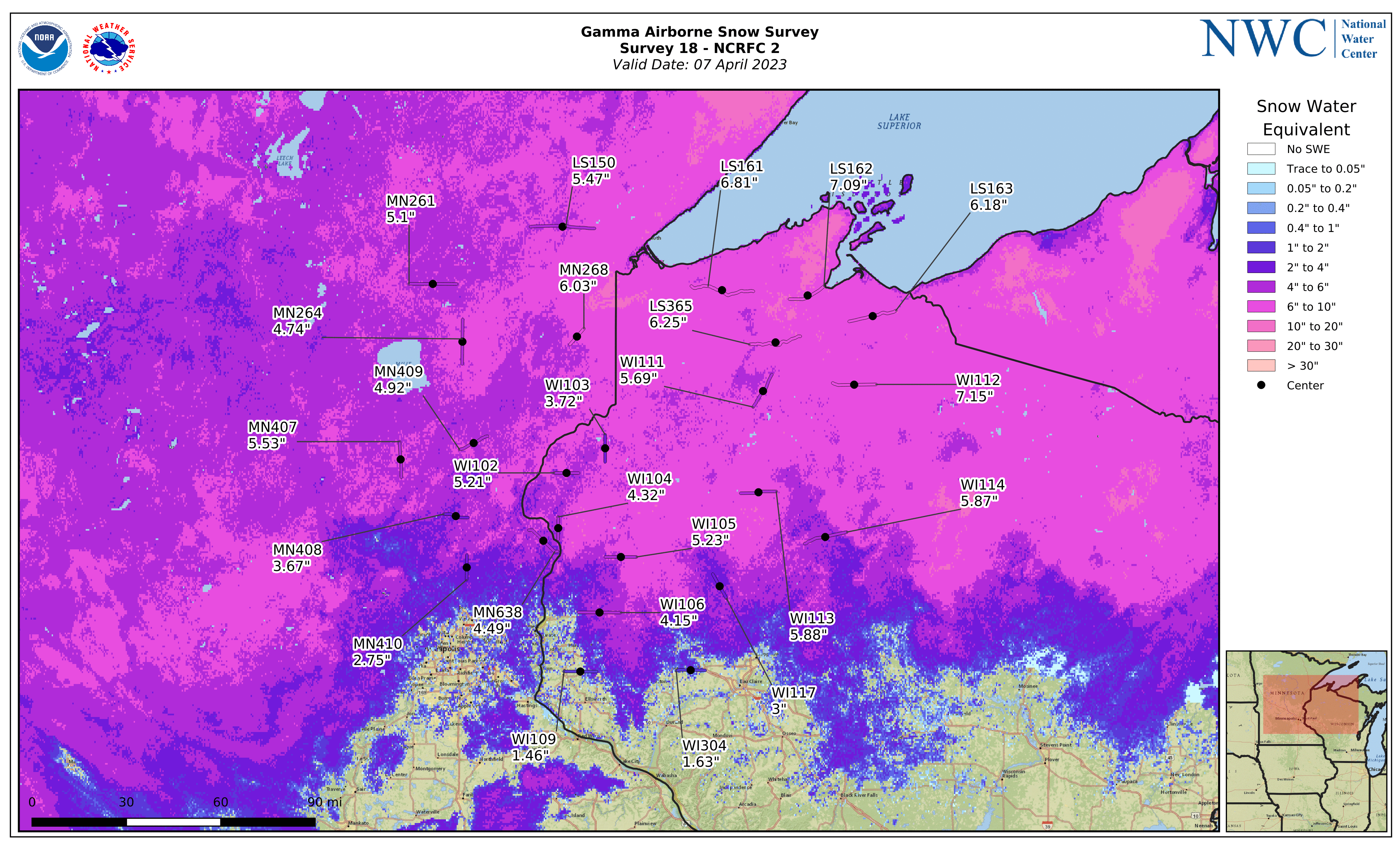
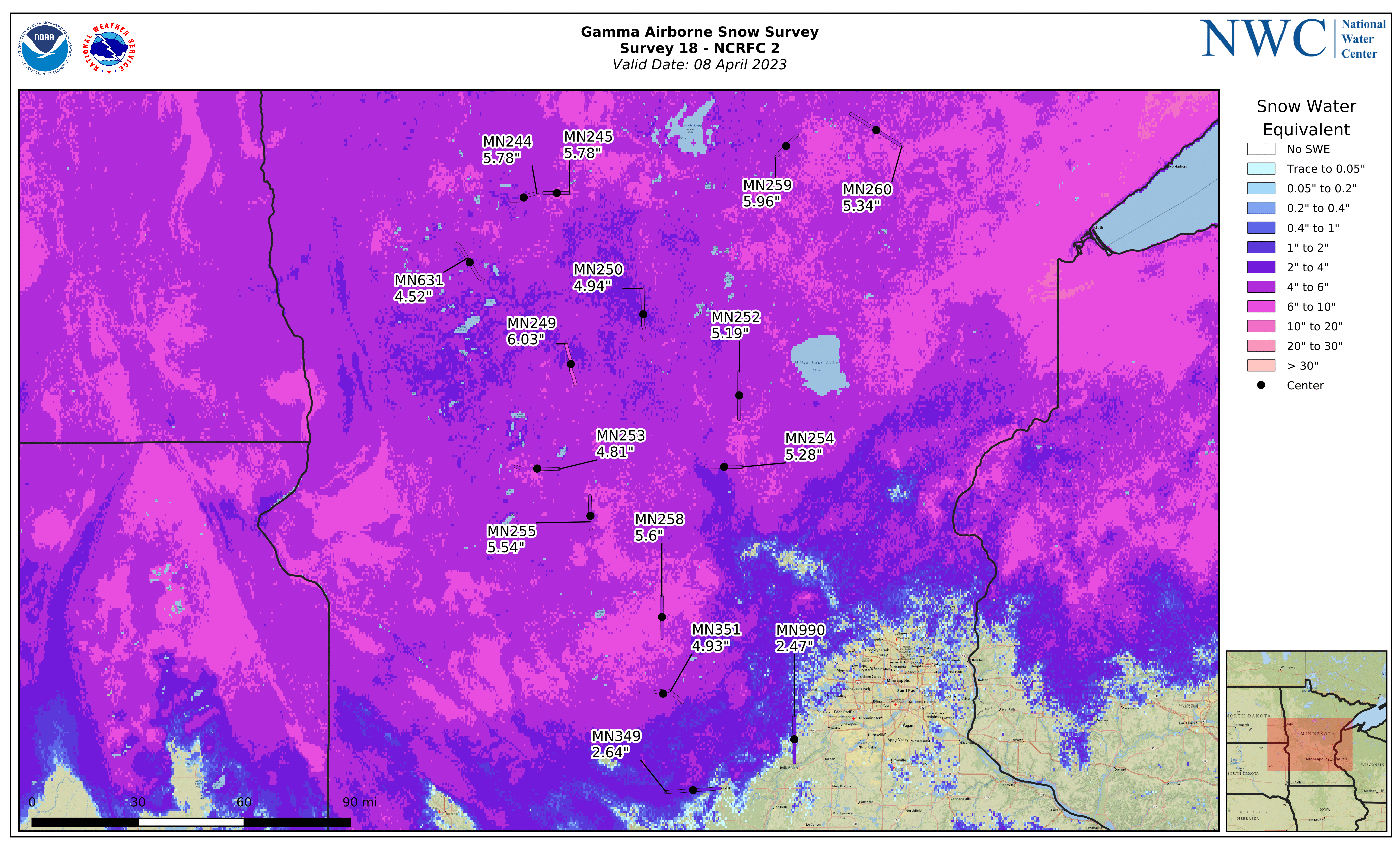
- Abnormally deep snowpack across the headwaters of the Mississippi River as well as other major river basins (Minnesota, St. Croix, Chippewa, Wisconsin) that feed into the mainstem of the Mississippi River; this snowpack contained approximately 4-8 inches of liquid equivalent.
- Colder than normal March limited early, gradual melting of the snowpack, keeping it longer into spring when it becomes more susceptible to rapid warm-ups and melting.
- An unusually warm (4 to 9°F warmer-than-normal) first half of April resulted in RAPID snowmelt into river systems that feed into the Mississippi River.
- An unusually wet April likely helped increase the height of the crest. Through April 22, precipitation anomalies ranged near normal to 4" above normal in the basins that flow into the Upper Mississippi River. The largest anomalies were found in the Black River in Wisconsin, and Minnesota Basin in Minnesota.
How can this flood threat change?
- Observed crests were roughly 12 to 18 hours ahead of schedule and 3 to 4 inches lower than expected, updated forecasts accounted for this.
- Official river forecasts include 24 hours of expected rainfall. Rainfall beyond this period, or higher than forecast rainfall (thunderstorms) will result in higher river levels than forecast. Continue to monitor the latest forecasts on the "Latest Stages / 7-Day Forecasts" tab.
National Water Center's SWE Flight Analyses from April 7th & 8th, 2023
What To Do?
- Follow local official instructions. Do not go around closed roadways. Do not enter flooded waters - hidden debris that the flood has picked up along the way can cause serious injury and/or trap you under the water with strong currents.


 Weather Story
 Weather Map
 Local Radar