Jeff Boyne, NWS La Crosse, WI
| Main Page | Weather Pattern | Sea Level Pressure | Winds | Snowfall | Marine | ||
| Media Accounts | Personal Accounts | Photos | Aftermath | Computer Simulation | Acknowledgements | ||
|
On November 11, 1940, a rapidly deepening low pressure system moved northeast from Kansas City, MO northeast through the Upper Mississippi River Valley and into the Upper Great Lakes. This low pressure area produced the lowest pressure reading ever recorded up to this time at Charles City, IA (28.92 inches), La Crosse, WI (28.72 inches), and Duluth, MN (28.66 inches). The lowest pressure recorded by this storm system in the United States was 28.57 inches at Houghton, MI (6:30 PM CST on November 11th). Some of the other low barometric pressure readings from are listed below. |
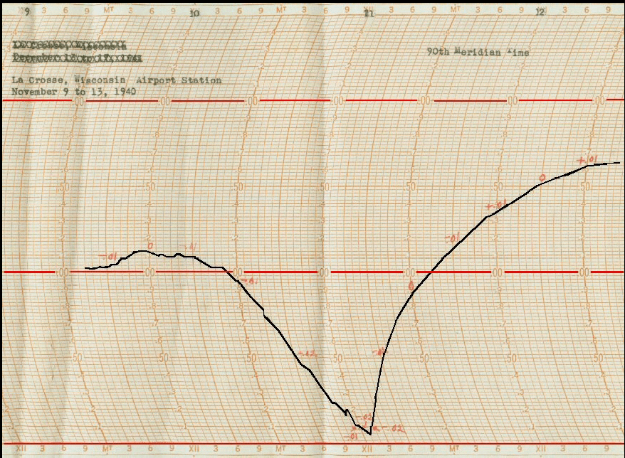
La Crosse, WI barograph tracing the barometric pressure from November 9-13, 1940. The lowest pressure during this storm was recorded (28.72 inches reduced to sea level) occurred around noon on November 11. This pressure reading is the fourth lowest in La Crosse. The only other dates to have lower pressures were on October 26, 2010 (28.685 inches); November 10, 1998 (28.691 inches); and April 3, 1982 (28.70 inches). |
Dubuque 28.99 inches
Des Moines 29.06 inches
Davenport 29.09 inches
Keokuk 29.15 inches
Sioux City 29.54 inches
Michigan...
Marquette 28.67 inches
Escanaba 28.77 inches
Sault Ste Marie 28.95 inches
Alpena 29.06 inches
Grand Rapids 29.10 inches
Lansing 29.16 inches
Detroit 29.32 inches
Minnesota...
Minneapolis 28.93 inches
Ohio...
Toledo 29.35 inches
Sandusky 29.40 inches
Cleveland 29.45 inches
Columbus 29.53 inches
Dayton 29.53 inches
Wisconsin...
Green Bay 28.80 inches
Madison 28.92 inches
Milwaukee 28.94 inches



 Weather Story
 Weather Map
 Local Radar
 Follow us on X
 Follow us on Facebook
 Follow us on YouTube
 ARX RSS Feed