
Extreme heat continues across the Southwest as temperatures may top 120 degrees. The heat may expand across the West and south-central U.S. into the middle of the month. Severe thunderstorms capable of severe wind gusts and large hail will be the primary hazards today across the northern Plains into the upper Midwest. Rainfall could be locally heavy across the Eastern U.S. today. Read More >

For Moderate/High/Extreme hazard risk, more detailed information will be provided via emailed briefings to core partners.
|
|
Active Tropical CyclonesIndicates areas/chances of tropical/sub-tropical cyclone development over the next 48 hours. |

|
Graphical Tropical Weather OutlookHighlights the location of areas of disturbed weather and shows the 48 hour probabilistic genesis potential. |
|
|
Tropical Cyclone Potential ImpactsThe TCI Graphics web site is an internet-based decision-support service consisting of at least four graphics: high wind impacts, coastal flooding impacts, inland flooding impacts, and tornado impacts. |
 |
Hurricane Local Statement Interactive Text ReaderIt is active whenever tropical cyclone watches/warnings are in effect locally, and refreshed with each issuance of the HLS by your local forecast office. |
|
|
Tropical Atlantic Weather Map
Surface analysis of weather features across the tropical Atlantic. |
 |
Tropical Atlantic Satellite Imagery
|
Surface AnalysisThe Weather Prediction Center (WPC) produces surface maps which depicts the analysis of highs, lows, fronts, troughs, outflow boundaries, squall lines, and drylines. NOAA nowCOAST - GIS mapping Portal |
 |
RadarWSR-88D Doppler Radar Caribou ME
|
|
|
Weather HazardsMap displays active watch, warnings, advisories and short term forecasts in the lower 48 states. Map automatically refreshes every five minutes. |
 |
National Data Buoy CenterNDBC provides hourly observations from a network of about 90 buoys and 60 Coastal Marine Automated Network stations. All stations measure wind (speed/direction/gust) and barometric pressure and air temperature. |
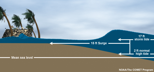
Storm SurgeAlong the coast, storm surge is often the greatest threat to life and property from a hurricane. The size of a storm surge for a particular location depends on a number of factors. Storm surge is very sensitive to the shape of the coast, and to changes in storm track, intensity, forward speed, and size. Tidal height at the time of maximum storm surge is an important factor. |
|
Saffir-Simpson Hurricane Wind Scale
Category 1 to 5 rating based on a hurricane's sustained wind speed. |
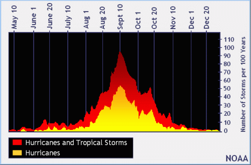
Tropical Cyclone ClimatologyThe official hurricane season for the Atlantic Basin (the Atlantic Ocean, the Caribbean Sea, and the Gulf of America) is from June 1st to November 30th. The peak of the season is from mid-August to late October. However, deadly hurricanes can occur anytime in the hurricane season. Tropical Cyclones - pdf brochure Updated April 2013 |
 |
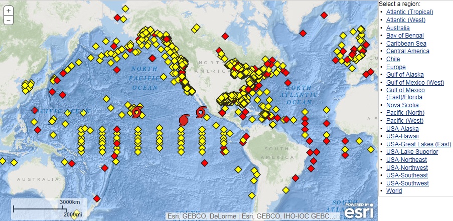
Historical Hurricane TracksNOAA Historical Hurricane Tracks Tool - interactive database. More than 6,000 tropical cyclones, ranging from 1842 and occurring in over seven major ocean basins around the world, are now searchable thanks to the incorporation of NOAA’s International Best Track Archive for Climate Stewardship (IBTrACS) data set.
|


 Coastal Flood