Overview
|
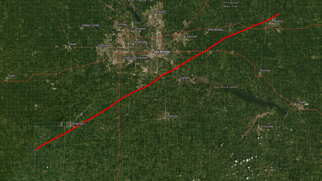
On March 5, 2022 three supercells swept across Iowa, producing several tornadoes. Two supercells in southern Iowa produced three tornadoes. Meanwhile, a single long track supercell produced multiple tornadoes from the southwest corner of Iowa all the way through central Iowa and into east central Iowa. The largest tornado moved across Madison, Warren, Polk, and Jasper counties for nearly 70 miles and at its peak produced winds of nearly 170 mph. This is the first EF-4 tornado in Iowa since October 4, 2013 which occurred in Woodbury and Cherokee Counties. This is second longest tornado in Iowa since 1980, behind the longest occurring on June 7, 1984 at a length of 117 miles across southern Iowa. Downloadable KMZ files are linked below each track map. This information remains preliminary as damage information continues to be gathered.
Other NWS Office Event Summaries:
Last update: March 12, 2022 2:15pm CST. |
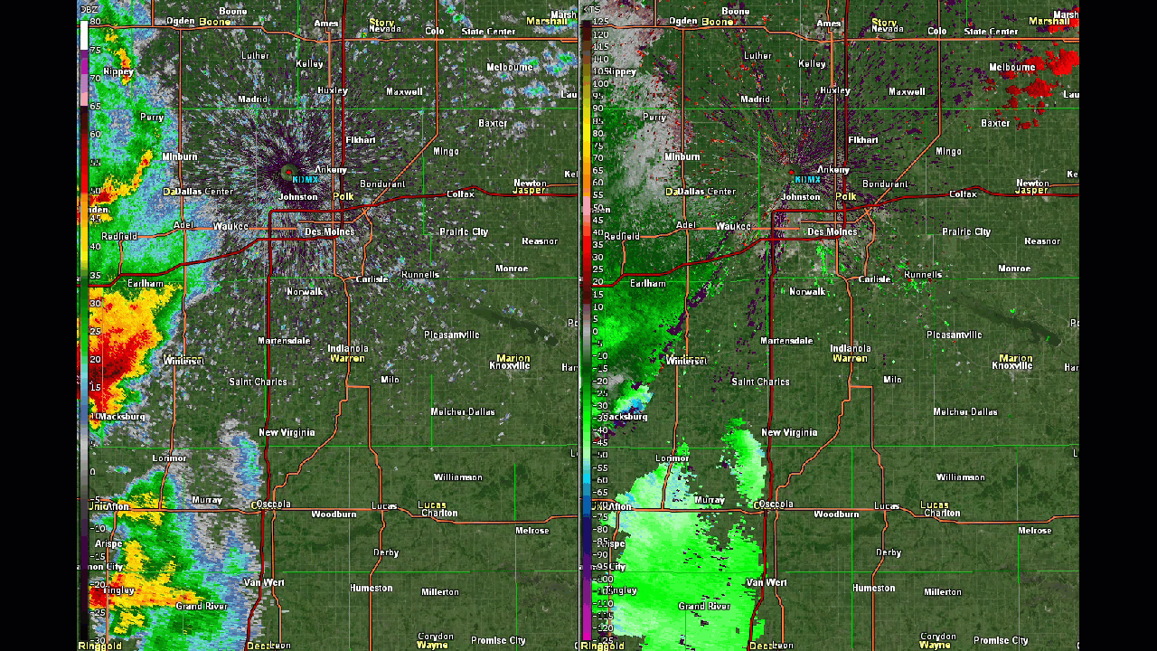 Radar loop of all three supercells during the central Iowa portion of storm evolution. |
 |
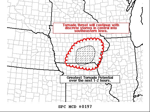 |
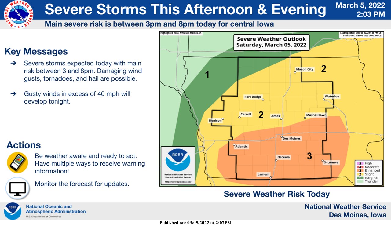
| Enhanced Risk issued March 5, 2022. | SPC Mesoscale Convective Discussion issued at 5:34pm. |
Tornadoes
|
Tornado #1 - Winterset through Newton
|
||||||||||||||||
|
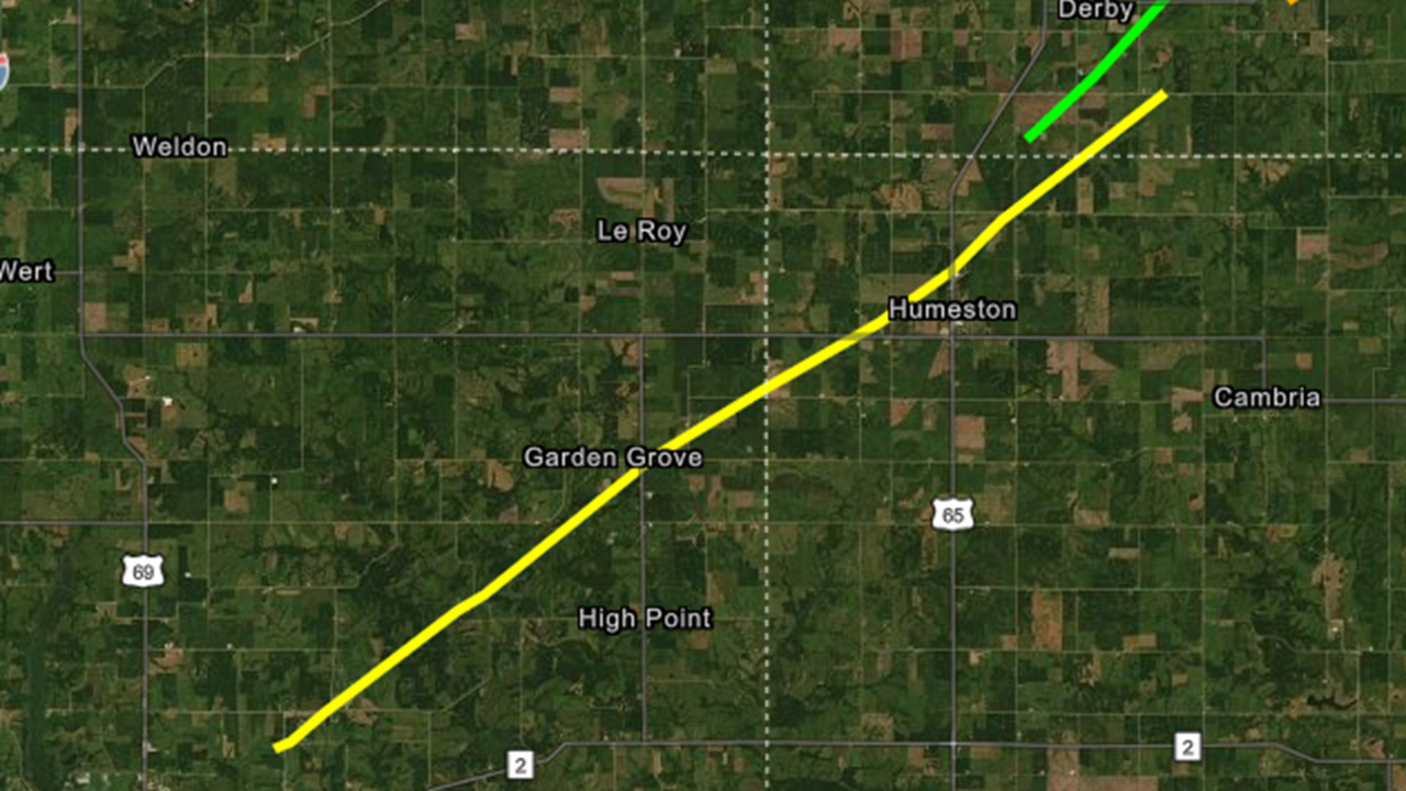
Tornado #2 - Garden Grove/Humeston
|
||||||||||||||||
|
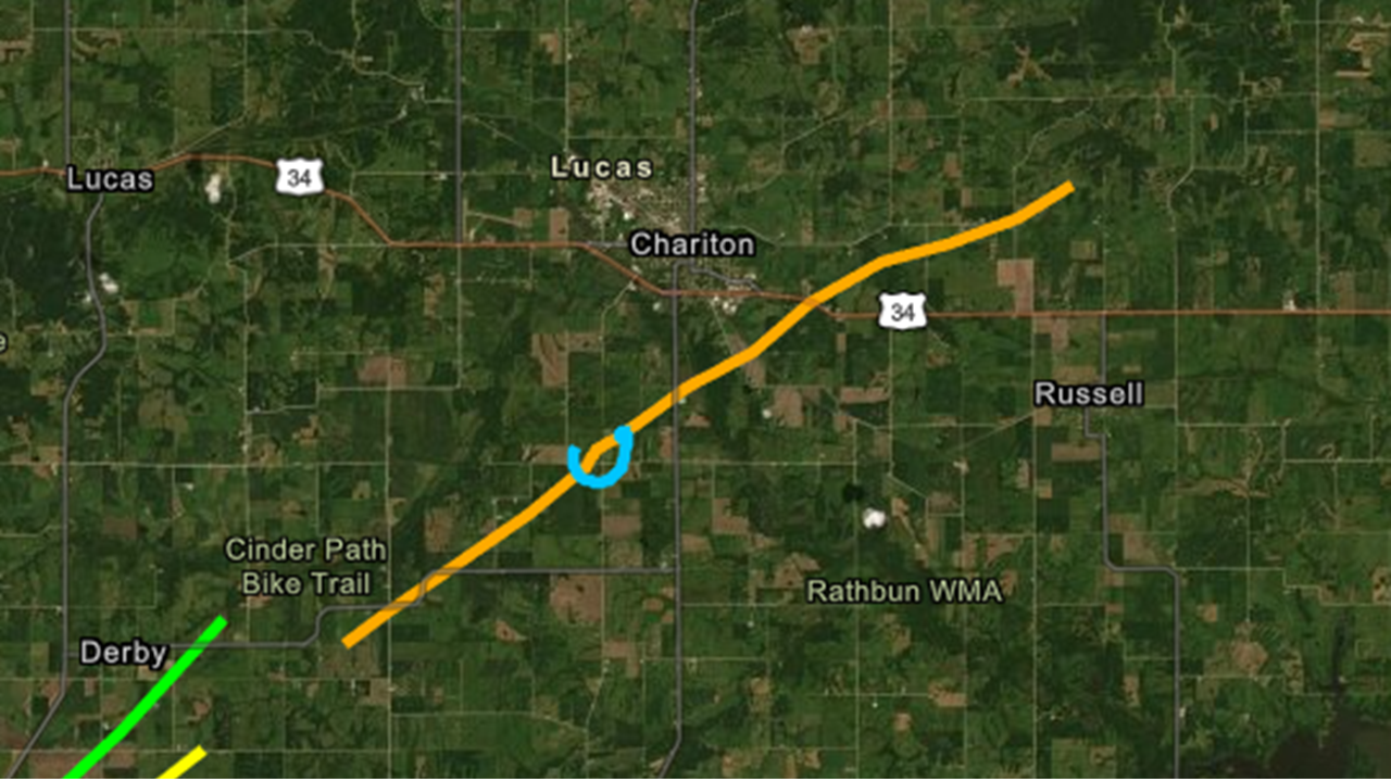
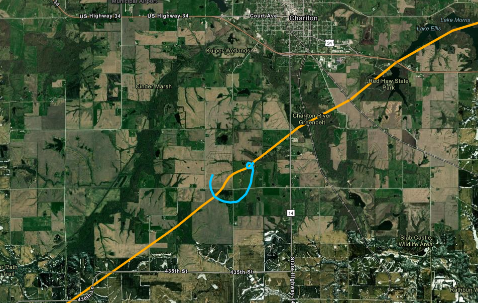
Tornado #3 - Chariton/Red Haw State Park Tornado
|
||||||||||||||||
|
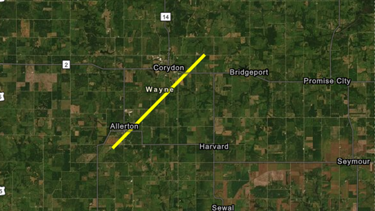
Tornado #4 - Allerton/Corydon
|
||||||||||||||||
|
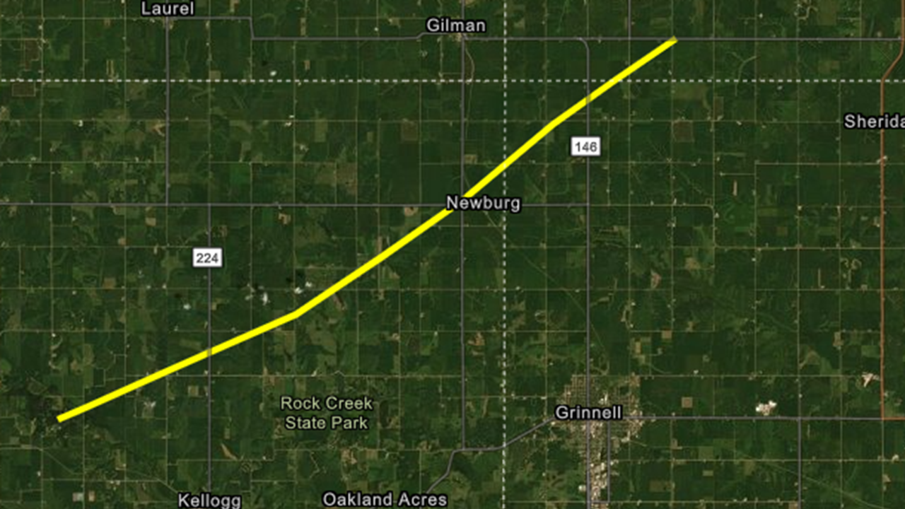
Tornado #5 - Kellogg
|
||||||||||||||||
|
Tornado #6 - Tama
|
||||||||||||||||
|
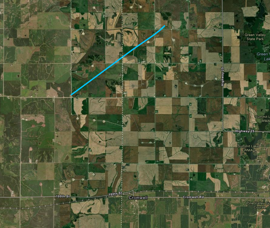
Tornado #7 - Cromwell
|
||||||||||||||||
|
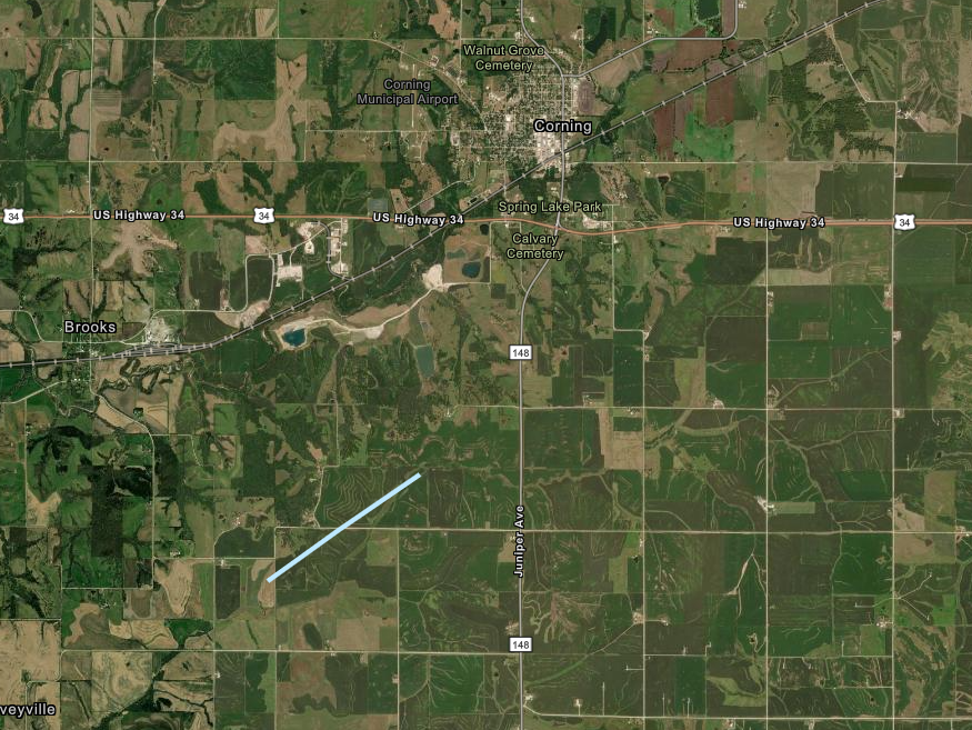
Tornado #8 - Corning
|
||||||||||||||||
|
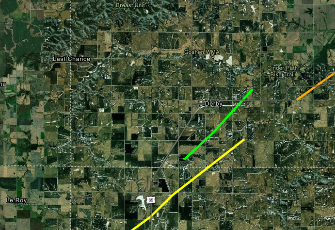
Tornado #9 - Derby
|
||||||||||||||||
|
Tornado #10 - Chariton satellite
|
||||||||||||||||
The Enhanced Fujita (EF) Scale classifies tornadoes into the following categories:
| EF0 Weak 65-85 mph |
EF1 Moderate 86-110 mph |
EF2 Significant 111-135 mph |
EF3 Severe 136-165 mph |
EF4 Extreme 166-200 mph |
EF5 Catastrophic 200+ mph |
 |
|||||
Storm Reports
Preliminary storm reports. Note that the number of tornado icons on the map below and in the text summary does not equal the number of tornadoes as some tornadoes have multiple reports.
Click map below to go to an interactive map viewer
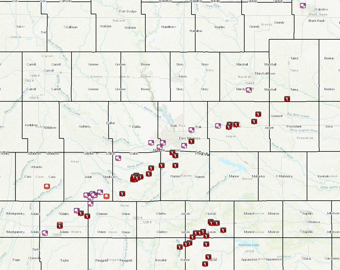
PRELIMINARY LOCAL STORM REPORT...SUMMARY
NATIONAL WEATHER SERVICE DES MOINES IA
1056 PM CST SAT MAR 5 2022
..TIME... ...EVENT... ...CITY LOCATION... ...LAT.LON...
..DATE... ....MAG.... ..COUNTY LOCATION..ST.. ...SOURCE....
..REMARKS..
0134 PM HAIL 3 SE DES MOINES 41.55N 93.57W
03/05/2022 E0.25 INCH POLK IA PUBLIC
0149 PM HAIL 1 NW COLFAX 41.69N 93.25W
03/05/2022 U0.75 INCH JASPER IA PUBLIC
REPORT FROM MPING: DIME (0.75 IN.).
0206 PM HAIL HAVERHILL 41.94N 92.96W
03/05/2022 E1.00 INCH MARSHALL IA PUBLIC
SOCIAL MEDIA PICTURE OF QUARTER SIZE HAIL.
0225 PM HAIL 1 N CEDAR FALLS 42.53N 92.45W
03/05/2022 E0.50 INCH BLACK HAWK IA PUBLIC
SOCIAL MEDIA.
0340 PM TORNADO 1 S CORNING 40.98N 94.74W
03/05/2022 ADAMS IA STORM CHASER
MULTIPLE REPORTS OF BRIEF TORNADO TOUCHDOWN
SOUTH OF CORNING.
0340 PM FUNNEL CLOUD CORNING 40.99N 94.74W
03/05/2022 ADAMS IA STORM CHASER
STORM CHASER REPORT OF FUNNEL CLOUD NEAR
CORNING.
0342 PM HAIL 1 SE NODAWAY 40.93N 94.88W
03/05/2022 E1.25 INCH ADAMS IA STORM CHASER
QUARTER TO PING PONG SIZED HAIL REPORTED
SOUTHEAST OF NODAWAY, IOWA.
0354 PM HAIL 3 W ORIENT 41.20N 94.47W
03/05/2022 E1.50 INCH ADAIR IA TRAINED SPOTTER
HAIL REPORT OF 1.5 INCHES WEST OF ORIENT,
IOWA VIA SPOTTERNETWORK SN#52257.
0355 PM FUNNEL CLOUD 1 SE CUMBERLAND 41.26N 94.86W
03/05/2022 CASS IA STORM CHASER
MULTIPLE STORM CHASER REPORTS OF A FUNNEL
CLOUD SE OF CUMBERLAND, IA.
0355 PM HAIL 5 NNE PRESCOTT 41.09N 94.58W
03/05/2022 E1.75 INCH ADAMS IA TRAINED SPOTTER
HAIL REPORT OF 1.75 INCHES NORTH OF
PRESCOTT, IOWA VIA SPOTTERNETWORK SN#52258.
0406 PM TORNADO 5 WNW CROMWELL 41.07N 94.54W
03/05/2022 ADAMS IA STORM CHASER
STORM CHASER CONFIRMED TORNADO ON GROUND
WITH VIDEO AND DAMAGE TO BARN STRUCTURE VIA
TWITTER.
0406 PM HAIL 4 W ORIENT 41.20N 94.49W
03/05/2022 E1.00 INCH ADAIR IA PUBLIC
HAIL REPORT OF 1 INCH VIA SPOTTERNETWORK W
OF ORIENT SN#52260.
0408 PM HAIL 3 SW ORIENT 41.18N 94.45W
03/05/2022 U1.75 INCH ADAIR IA PUBLIC
REPORT FROM MPING: GOLF BALL (1.75 IN.).
0410 PM TORNADO 1 NW CROMWELL 41.05N 94.48W
03/05/2022 ADAMS IA STORM CHASER
STORM CHASER REPORT OF TORNADO NW OR
CROMWELL VIA TWITTER.
0413 PM HAIL 3 ENE ORIENT 41.22N 94.36W
03/05/2022 E2.50 INCH ADAIR IA TRAINED SPOTTER
SPOTTER REPORT OF ONGOING TENNIS BALL HAIL
EAST NORTHEAST OF ORIENT.
0419 PM HAIL 1 NW ORIENT 41.21N 94.43W
03/05/2022 E2.00 INCH ADAIR IA STORM CHASER
2+ INCH HAIL REPORT VIA STORM CHASER ON
TWITTER NW OR ORIENT, IA.
0422 PM HAIL ORIENT 41.20N 94.41W
03/05/2022 E2.00 INCH ADAIR IA TRAINED SPOTTER
TRAINED SPOTTER REPORT OF 2 INCH HAIL IN
ORIENT, IA SN#52263.
0424 PM FUNNEL CLOUD 6 WSW MACKSBURG 41.19N 94.30W
03/05/2022 ADAIR IA TRAINED SPOTTER
TRAINED SPOTTER REPORT OF A FUNNEL CLOUD 6
MILES WEST SOUTHWEST OF MACKSBURG, IA
SN#52264.
0428 PM TORNADO 2 E MACKSBURG 41.21N 94.15W
03/05/2022 MADISON IA STORM CHASER
STORM CHASER CONFIRMED TORNADO VIA TWITTER.
0435 PM TORNADO WINTERSET 41.34N 94.02W
03/05/2022 MADISON IA TRAINED SPOTTER
TORNADO ONGOING WITH DEBRIS S OF WINTERSET -
MULTIPLE REPORTS VIA TRAINED SPOTTER AND
EMERGENCY MANAGERS.
0435 PM TORNADO 2 SW WINTERSET 41.31N 94.05W
03/05/2022 MADISON IA TRAINED SPOTTER
TRAINED SPOTTER REPORTS LARGE TORNADO ON THE
GROUND SOUTHWEST OF WINTERSET, APPROACHING
TIME. DEBRIS VISIBLE. LOCATION ESTIMATED.
0447 PM TORNADO 2 SSW WINTERSET 41.31N 94.04W
03/05/2022 MADISON IA TRAINED SPOTTER
TORNADO DAMAGE REPORT VIA SPOTTER NETWORK -
HOMES AND TREES DAMAGED AND A GARAGE WAS
DESTROYED ON 169 (SN#52265).
0448 PM TORNADO 2 SSW WINTERSET 41.31N 94.03W
03/05/2022 MADISON IA STORM CHASER
TORNADO DAMAGE IN WINTERSETT TO SHED
REPORTED VIA TWITTER.
0449 PM HAIL ORIENT 41.20N 94.42W
03/05/2022 E2.75 INCH ADAIR IA STORM CHASER
STORM CHASER REPORT OF BASEBALL SIZE HAIL
ACCOMPANIED WITH SIGNIFICANT DAMAGE TO
VEHICLES VIA TWITTER.
0449 PM HAIL 4 SW EARLHAM 41.46N 94.19W
03/05/2022 U1.00 INCH MADISON IA PUBLIC
REPORT FROM MPING: QUARTER (1.00 IN.).
0450 PM TORNADO 1 WSW WINTERSET 41.33N 94.04W
03/05/2022 MADISON IA TRAINED SPOTTER
TORNADO DAMAGE REPORT VIA SPOTTER NETWORK -
BARNS DESTROYED AND HOUSES BADLY DAMAGED IN
WINTERSET (SN#52266).
0451 PM TORNADO 2 ESE WINTERSET 41.33N 93.98W
03/05/2022 MADISON IA TRAINED SPOTTER
TORNADO DAMAGE REPORTED VIA SPOTTER NETWORK
- TREE DAMAGE AND MINOR DAMAGE TO A HOME AT
THIS LOCATION. (SN#52267).
0455 PM HAIL 1 W WEST DES MOINES 41.57N 93.77W
03/05/2022 E0.25 INCH POLK IA TRAINED SPOTTER
PEA SIZED HAIL REPORT VIA TRAINED SPOTTER
PK1011.
0500 PM TORNADO 1 SSE WINTERSET 41.32N 94.01W
03/05/2022 MADISON IA TRAINED SPOTTER
TORNADO DAMAGE REPORT VIA SPOTTER NETWORK -
12 TREES SNAPPED BRANCHES SNAPPED, PATH A
COUPLE HUNDRED YARDS WIDE ON CLARK TOWER
ROAD 1/2 MILE NORTH OF ST CHARLES ROAD SOUTH
OF WINTERSET, IOWA (SN#52268).
0507 PM TORNADO 3 NW MARTENSDALE 41.41N 93.78W
03/05/2022 WARREN IA STORM CHASER
STORM CHASER REPORT OF TORNADO DAMAGE ALONG
I-35 AND 2 MILES N OR RT. 92 VIA TWITTER.
0509 PM TORNADO NORWALK 41.50N 93.68W
03/05/2022 WARREN IA FIRE DEPT/RESCUE
MULTIPLE REPORTS OF TORNADO ON THE GROUND
VIA PUBLIC AND FIRE FIGHTER CONFIRMED IN
NORWALK.
0512 PM TORNADO 3 N PATTERSON 41.39N 93.88W
03/05/2022 MADISON IA TRAINED SPOTTER
TORNADO DAMAGE REPORT VIA SPOTTER NETWORK -
THERE IS DAMAGE TO A STRUCTURE HERE AS WELL
AS EXTENSIVE TREE DAMAGE IN THIS AREA
(SN#52270).
0512 PM TORNADO SPRING HILL 41.41N 93.65W
03/05/2022 WARREN IA TRAINED SPOTTER
TORNADO ONGOING REPORT VIA SPOTTER NETWORK -
LARGE RAIN WRAPPED MULTI VORTEX TORNADO ON
THE GROUND 2 MILES NORTH OF MY LOCATION
MOVING NE (SN#52269).
0515 PM HAIL 3 SSW WAUKEE 41.57N 93.88W
03/05/2022 E0.25 INCH DALLAS IA TRAINED SPOTTER
SPOTTER REPORT OF PEA SIZED HAIL SSW OF
WAUKEE.
0520 PM TORNADO 2 SE NORWALK 41.48N 93.65W
03/05/2022 WARREN IA TRAINED SPOTTER
TORNADO DAMAGE REPORT VIA SPOTTER NETWORK -
APPARENT DAMAGE TO SEVERAL HOUSES AND
STRUCTURES JUST SOUTH OF HWY G24 AND R57 IN
NORWALK. APPARENT TORNADO PATH (SN#52271).
0521 PM TORNADO 1 W PATTERSON 41.35N 93.90W
03/05/2022 MADISON IA STORM CHASER
STORM CHASER REPORT OF TORNADO DAMAGE NEAR
PATTERSON, IA VIA TWITTER.
0523 PM TORNADO 1 W HUMESTON 40.86N 93.52W
03/05/2022 WAYNE IA PUBLIC
TORNADO REPORT OF A TORNADO ON THE GROUND
WEST OF HUMESTON VIA PUBLIC AND STORM
CHASER.
0525 PM TORNADO 3 WSW HUMESTON 40.85N 93.55W
03/05/2022 WAYNE IA EMERGENCY MNGR
EMERGENCY MANAGEMENT RELAYED LAW ENFORCEMENT
REPORT OF A TORNADO ON THE GROUND 3 MILES W
AND 1 MILE S OF HUMESTON. AT LEAST ONE HOME
DAMAGED.
0533 PM TORNADO 3 N HUMESTON 40.90N 93.49W
03/05/2022 WAYNE IA PUBLIC
TORNADO REPORT VIA TWITTER.
0534 PM HAIL 1 ESE PLEASANT HILL 41.58N 93.50W
03/05/2022 E2.50 INCH POLK IA PUBLIC
PUBLIC REPORT OF 2.50 INCH OR GREATER HAIL
STONES IN PLEASANT HILL VIA TWITTER.
0535 PM TORNADO 3 W MILLERTON 40.85N 93.36W
03/05/2022 WAYNE IA STORM CHASER
STORM CHASER REPORT OF TWO TORNADOES ON THE
GROUND WEST OF MILLERTON.
0536 PM TORNADO 2 E DERBY 40.93N 93.42W
03/05/2022 LUCAS IA STORM CHASER
STORM CHASERS REPORTED TORNADO STILL ON THE
GROUND JUST EAST OF DERBY. LOCATION
ESTIMATED.
0537 PM TORNADO 5 NW MILLERTON 40.91N 93.36W
03/05/2022 LUCAS IA PUBLIC
TORNADO ON THE GROUND REPORTED VIA PUBLIC.
0537 PM HAIL 3 SW WEST DES MOINES 41.54N 93.80W
03/05/2022 E0.25 INCH DALLAS IA TRAINED SPOTTER
HAIL REPORT VIA SPOTTER NETWORK.
0538 PM TORNADO 4 ENE DERBY 40.94N 93.39W
03/05/2022 LUCAS IA PUBLIC
TORNADO REPORT VIA PHONE CALL.
0544 PM TORNADO DERBY 40.93N 93.46W
03/05/2022 LUCAS IA STORM CHASER
STORM CHASER REPORT OF TWIN TORNADOES ON THE
GROUND EAST OF DERBY.
0546 PM TORNADO LAMBS GROVE 41.70N 93.08W
03/05/2022 JASPER IA PUBLIC
TORNADO ON THE GROUND, HOUSE REPORTEDLY
FLATTENED.
0548 PM TORNADO 1 SW CHARITON 41.01N 93.32W
03/05/2022 LUCAS IA TRAINED SPOTTER
TORNADO REPORTED VIA SPOTTER NETWORK -
FAMILY MEMBER JUST TEXTED ME A PICTURE OF A
CONE TORNADO IN PROGRESS JUST SW OF CHARITON
JUST A COUPLE MINUTES AGO. THEY ARE SEEKING
SHELTER NOW.
0554 PM TORNADO GARDEN GROVE 40.83N 93.61W
03/05/2022 DECATUR IA PUBLIC
PUBLIC REPORT VIA PHONE CALL - HEAVY DAMAGE,
ROOFS RIPPED OFF, METAL BUILDING
FLATTENED/COMPLETELY GONE.
0554 PM TORNADO 1 S CHARITON 41.00N 93.31W
03/05/2022 LUCAS IA BROADCAST MEDIA
TORNADO DAMAGE REPORT VIA NWSCHAT - CITY OF
CHARITON IS FINE. 1 MILE SOUTH OF TOWN HAS A
ROW OF 15 POWER POLES DOWN.
0555 PM TORNADO 1 W CORYDON 40.76N 93.34W
03/05/2022 WAYNE IA LAW ENFORCEMENT
SHERIFF RELAYED TORNADO REPORT ON THE GROUND
IN CORYDON.
0559 PM TORNADO 3 W LAMBS GROVE 41.70N 93.14W
03/05/2022 JASPER IA STORM CHASER
STORM CHASER REPORT OF SIGNIFICANT TORNADO
DAMAGE WITH TREES SNAPPED AND STRUCTURAL
DAMAGE VIA TWITTER.
0559 PM TORNADO 2 SE CHARITON 41.00N 93.28W
03/05/2022 LUCAS IA BROADCAST MEDIA
TORNADO DAMAGE VIA NWSCHAT - SIGNIFICANT
HOME DAMAGE 2 SE OF CHARITON. ROOF AND WALLS
GONE.
0607 PM HAIL 1 W ALTOONA 41.66N 93.50W
03/05/2022 U1.00 INCH POLK IA PUBLIC
REPORT FROM MPING: QUARTER (1.00 IN.).
0612 PM TORNADO KELLOGG 41.72N 92.91W
03/05/2022 JASPER IA AMATEUR RADIO
TORNADO REPORTED ON THE GROUND NORTHEAST OF
KELLOGG VIA NWSCHAT.
0612 PM TORNADO 2 S RUSSELL 40.95N 93.20W
03/05/2022 LUCAS IA PUBLIC
TORNADO IMAGE FROM PUBLIC VIA FACEBOOK.
0615 PM TORNADO 5 NE KELLOGG 41.77N 92.87W
03/05/2022 JASPER IA PUBLIC
0617 PM TORNADO 4 WSW LAMBS GROVE 41.68N 93.15W
03/05/2022 JASPER IA PUBLIC
TORNADO DAMAGE VIA SPOTTER NETWORK - 18
WHEELER OVERTURNED (SN#52273).
0617 PM TORNADO ALLERTON 40.71N 93.37W
03/05/2022 WAYNE IA TRAINED SPOTTER
DESTROYED TRAILER HOME, HEAVILY DAMAGED
RESIDENCY ON THE SOUTH SIDE OF TOWN. TREES
DOWN. SPOTTER ID: WN400.
0621 PM TORNADO 1 ESE PLEASANT HILL 41.58N 93.50W
03/05/2022 POLK IA EMERGENCY MNGR
EMERGENCY MANAGER REPORT OF MULTIPLE HOUSES
IN AREA LEVELED VIA NWSCHAT.
0623 PM TORNADO 4 ENE DERBY 40.94N 93.39W
03/05/2022 LUCAS IA STORM CHASER
TORNADO REPORT VIA TWITTER.
0624 PM TORNADO 3 ESE CHARITON 41.00N 93.26W
03/05/2022 LUCAS IA TRAINED SPOTTER
TORNADO DAMAGE REPORT VIA SPOTTER NETWORK -
- SIGNIFICANT STRUCTURE DAMAGE FROM EARLIER
TORNADO. LOTS OF BUILDINGS AND SOME HOMES
DAMAGE. GAS LEAKING. MAJOR TREE DAMAGE
(SN#52274).
0641 PM TORNADO 6 SSW TAMA 41.88N 92.60W
03/05/2022 TAMA IA TRAINED SPOTTER
TORNADO REPORT VIA SPOTTER NETWORK - CONE
TORNADO WITH POWER FLASHES 4 NNE NEAR TAMA.
(SN#52275).
Radar
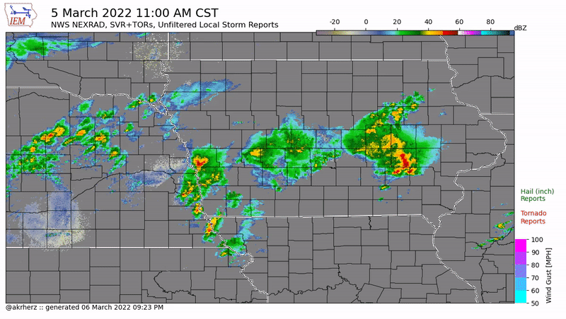 |
| Radar loop of severe thunderstorm and tornado warnings and storm reports on March 5, 2022. Courtesy of the Iowa Environmental Mesonet and its daily feature. |
 |
|
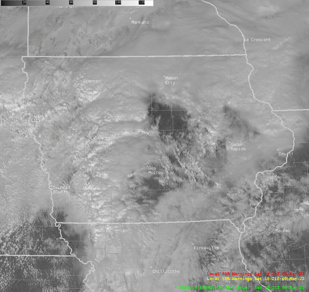
GOES-East 5 minute loop of visible imagery with warning polygons (red = tornado; yellow = severe thunderstorm) overlaid.
|
 |
|
GOES-East 1 minute loop of infrared imagery with warning polygons (red = tornado; yellow = severe thunderstorm) overlaid.
|
 |
|
GOES-East 5 minute visible and infrared blended (sandwich) product.
|
 |
|
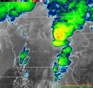
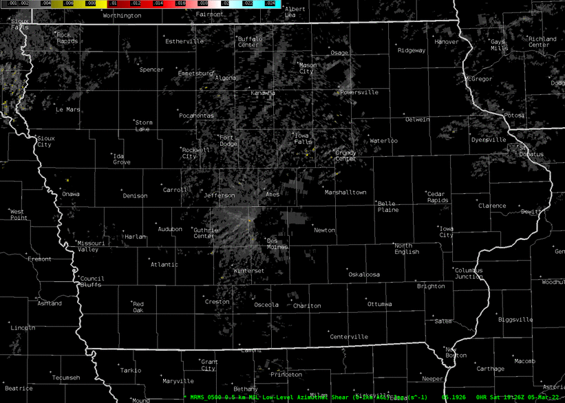
Multi-Radar Multi-Sensor (MRMS) low level rotation tracks with reds and cyan/light blues indicating strong rotation. |
|
|
Environment
Synoptic Environment
 |
 |
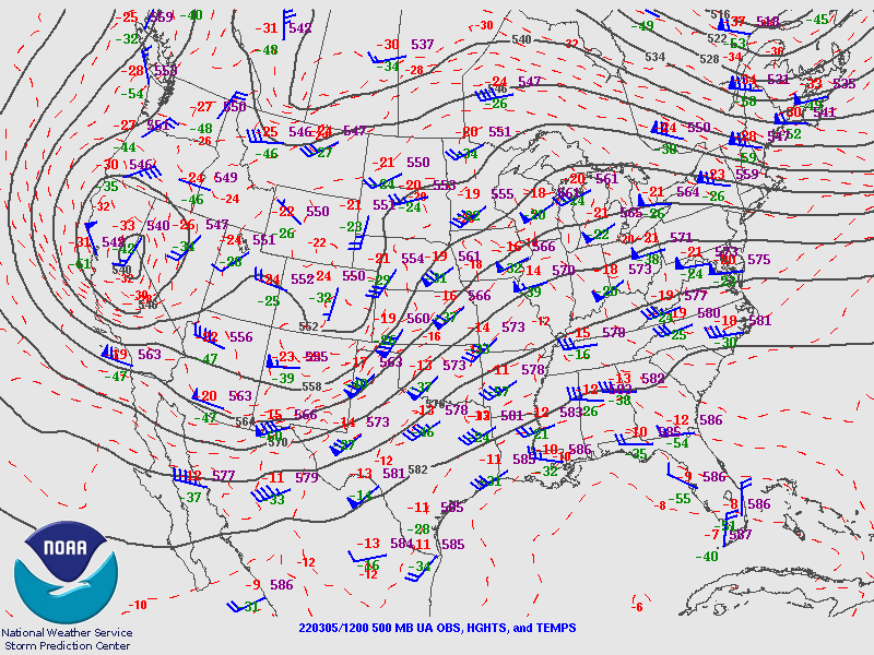 |
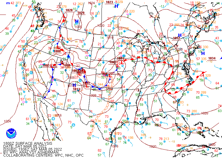
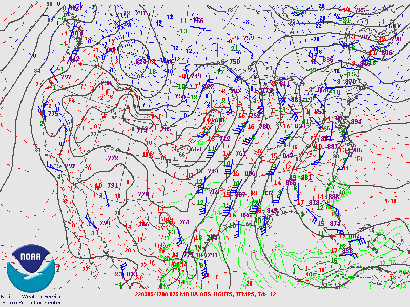
| Figure 1: Analyzed surface map at 18z (noon) March 5th. | Figure 2: 925mb map at 12z (6 am) March 5th. | Figure 3: 500mb map at 12z (6 am) March 5th. |
Near-storm Environment
 |
 |
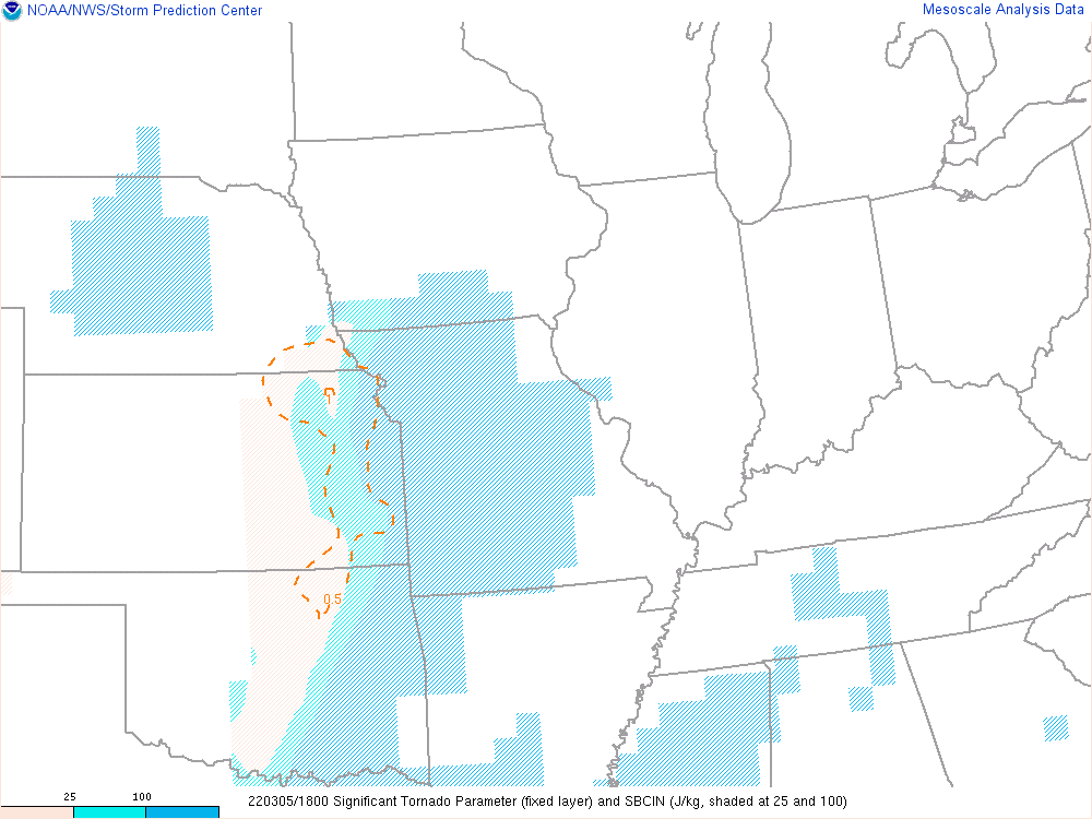 |
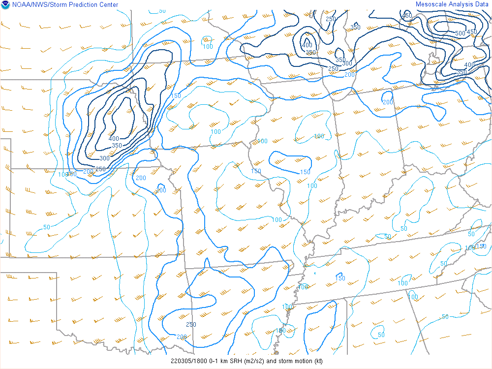
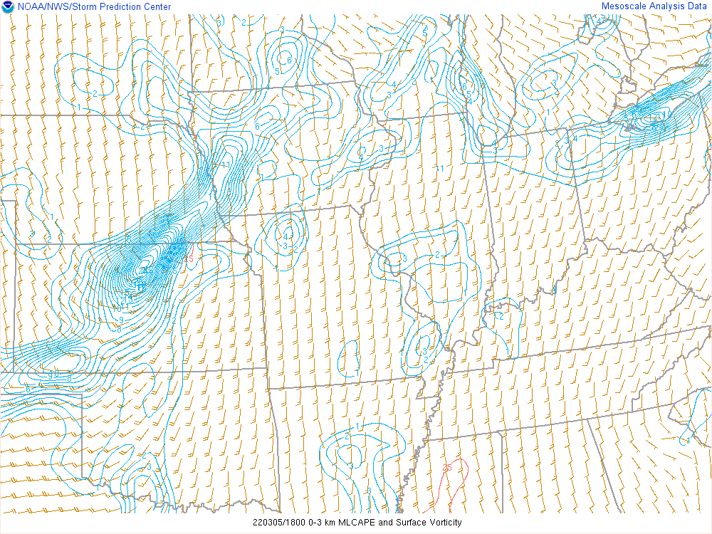
| Figure 4: The Storm Relative Helicity (m2/s2) is a measure of the potential for cyclonic updraft rotation in right-moving supercells. Larger values of 0-1-km SRH (greater than 100 m2 s-2) suggest an increased threat of tornadoes with supercells. For SRH, larger values are generally better, but there are no clear thresholds between non-tornadic and significant tornadic supercells. | Figure 5: Loop of the 3-km CAPE (J/kg) & Surface Vorticity. CAPE in the lowest 3-km above ground level, and surface relative vorticity. Areas of large 0-3-km CAPE tend to favor strong low-level stretching, and can support tornado formation when co-located with significant vertical vorticity near the ground. | Figure 6: Loop of the Significant Tornado Parameter. Significant Tornado Parameter utilizes 0-1 km storm relative helicity, surface based CAPE, surface based LCL height, and 0-6 km bulk wind difference. Historically, the majority of significant tornadoes (EF-2+) have been associated with values over 1, while most non-tornadic supercells have been associated with values less than 1. |
Photos/Videos
Additional photos/videos on this Twitter Moment
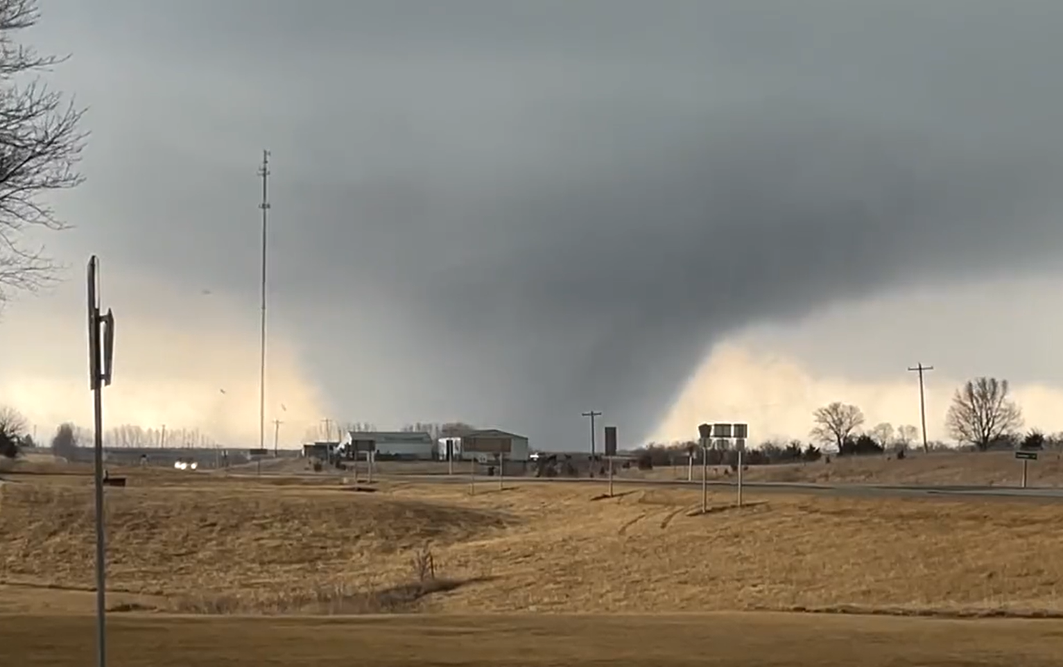
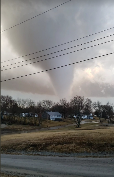
Winterset thru Newton
 |
 |
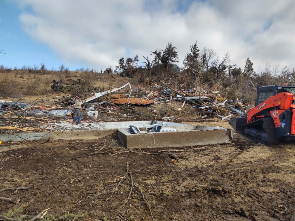 |
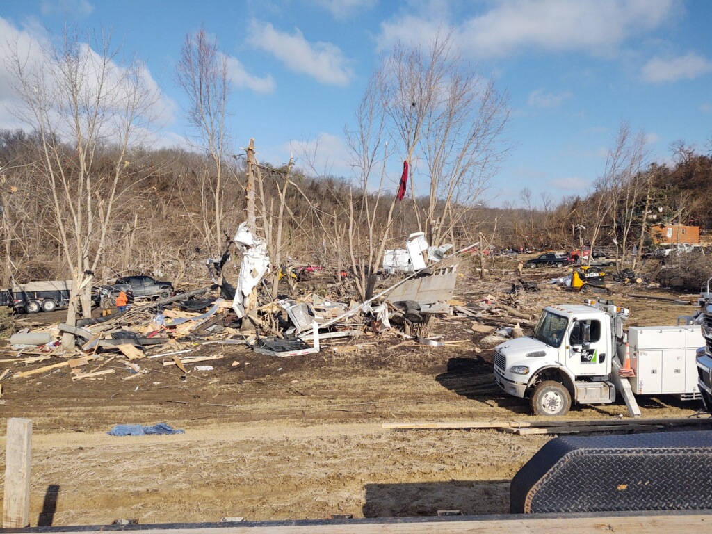
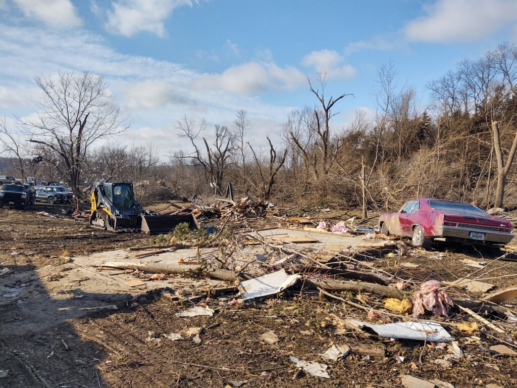
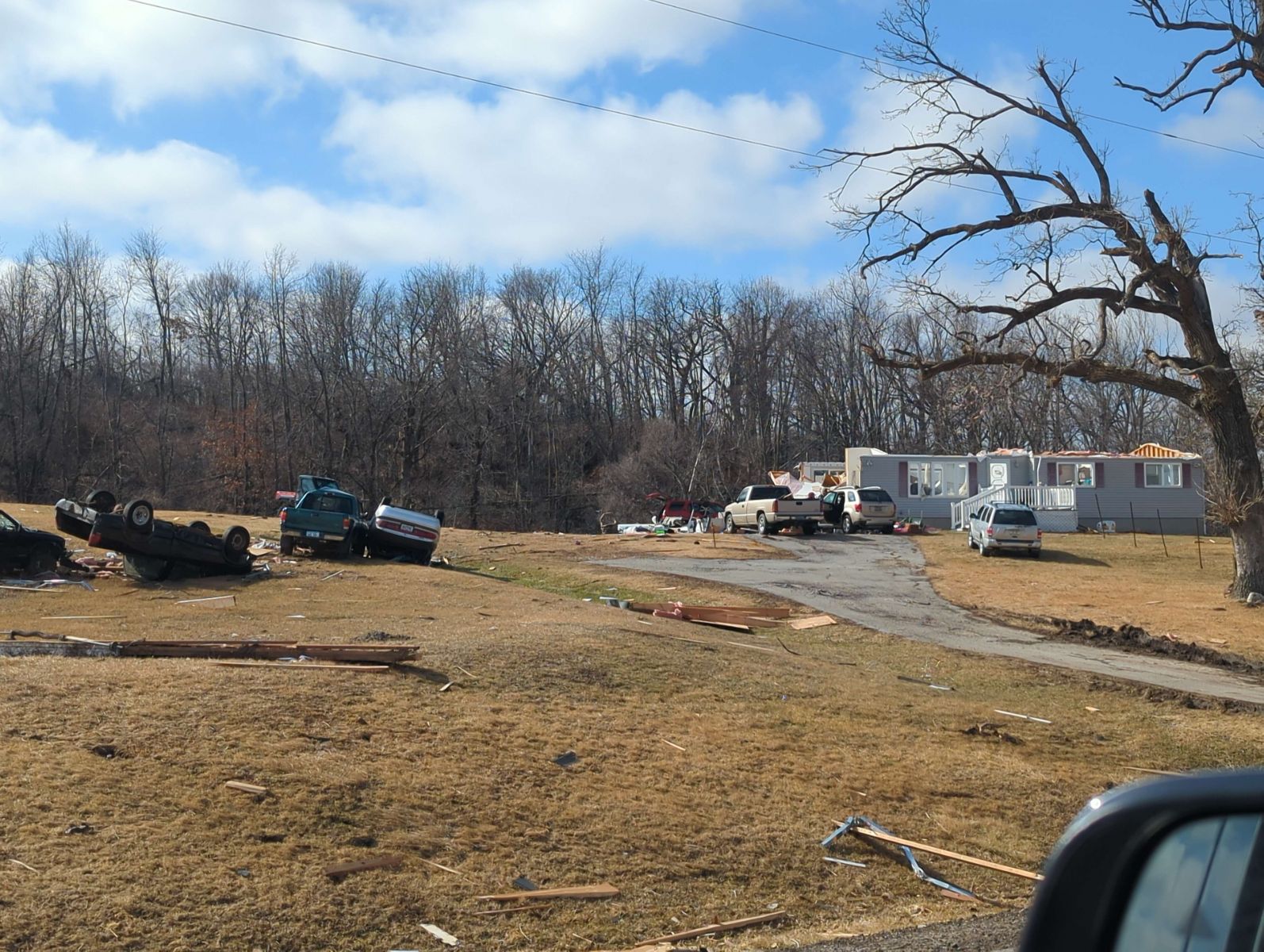
| Large wedge tornado moving through Winterset. Photo courtesy of Roger Riley. | Significant damage near Winterset. Photo from NWS storm survey. | Significant damage near Winterset. Photo from NWS storm survey. |
 |
 |
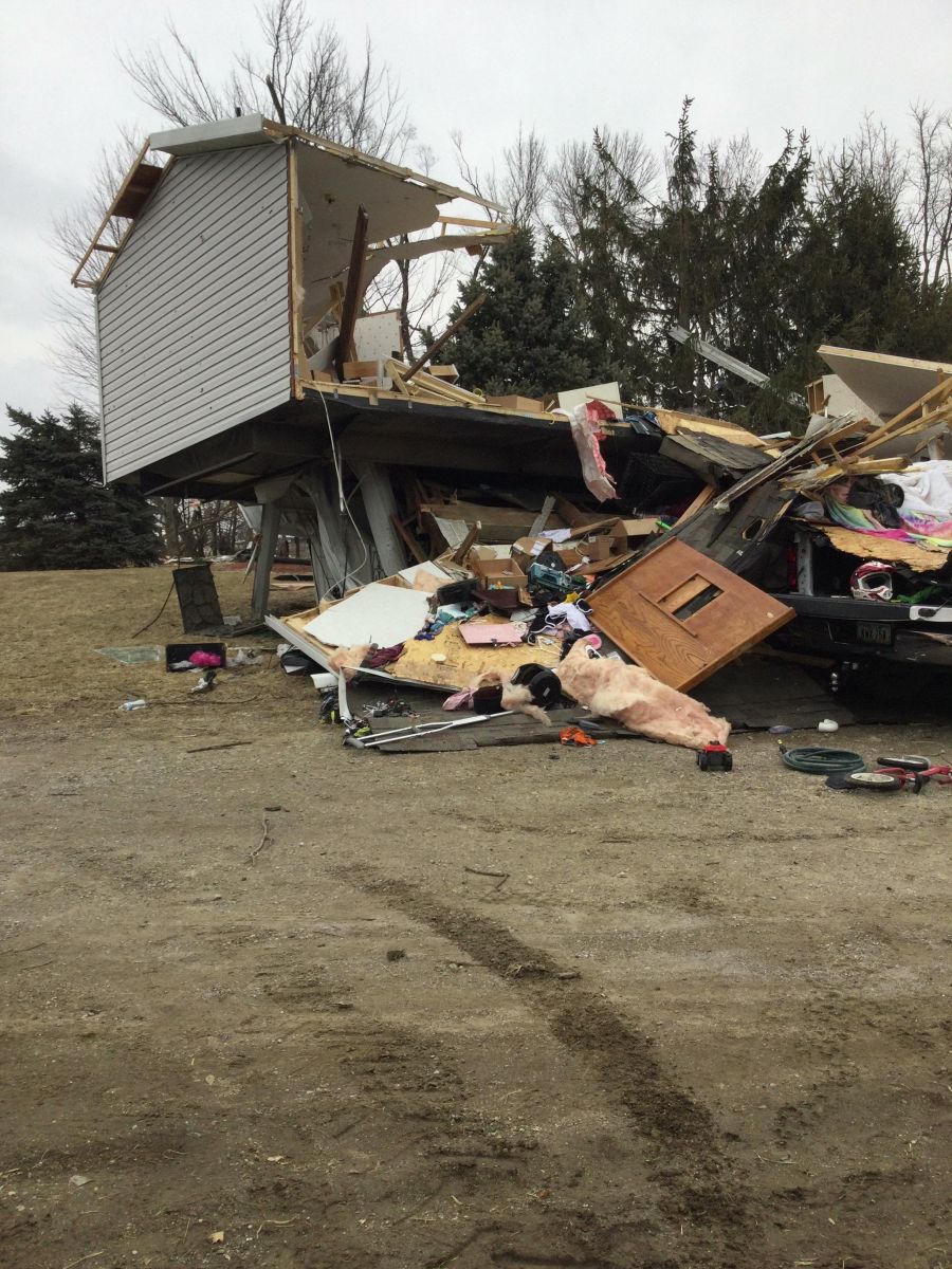 |
| Significant damage near Winterset. Photo from NWS storm survey. | Damage to an outbuilding near Norwalk. Photo from NWS storm survey. | Total loss of a home east of Des Moines. Photo from NWS storm survey. |
 |
 |
 |
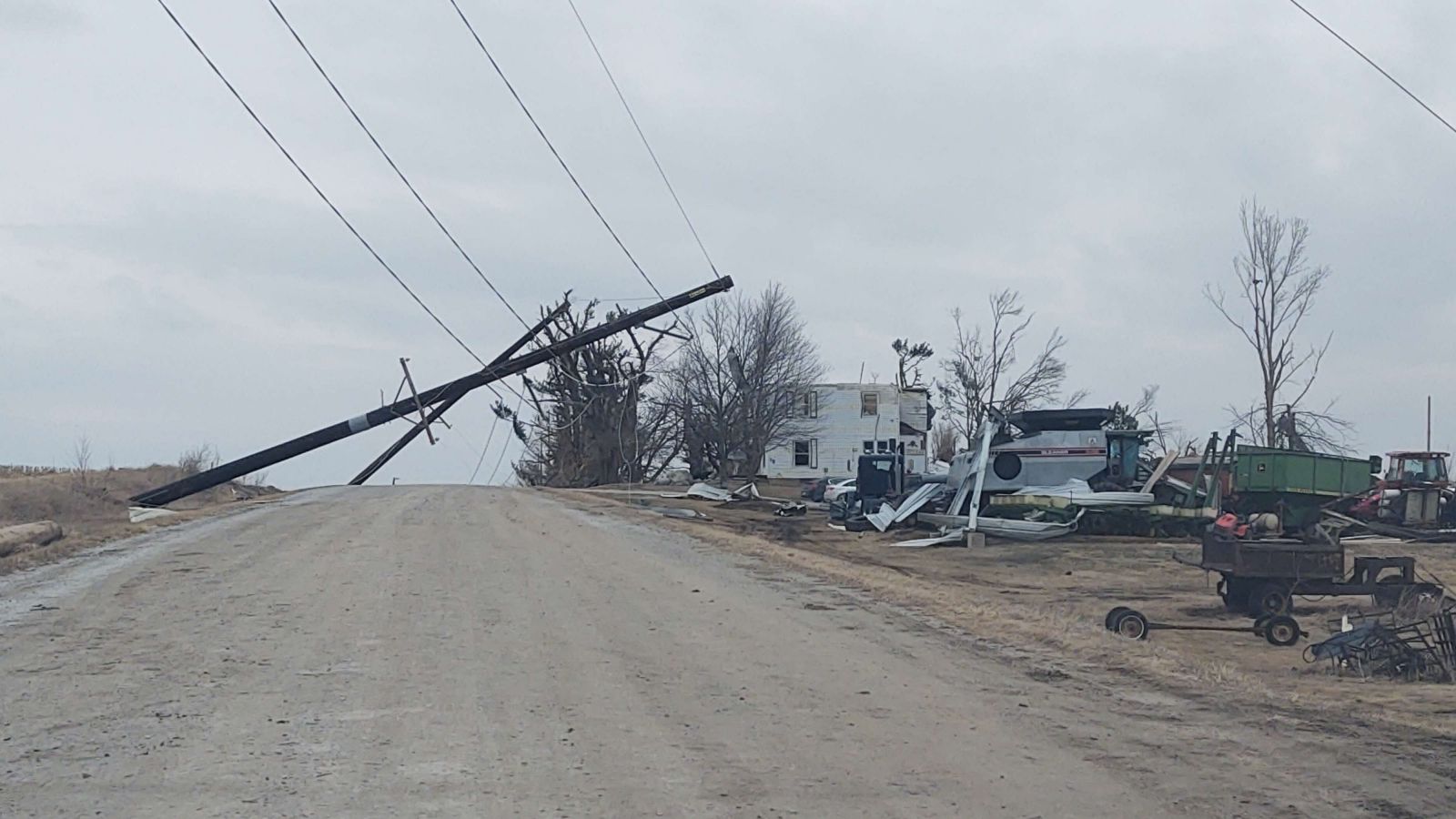
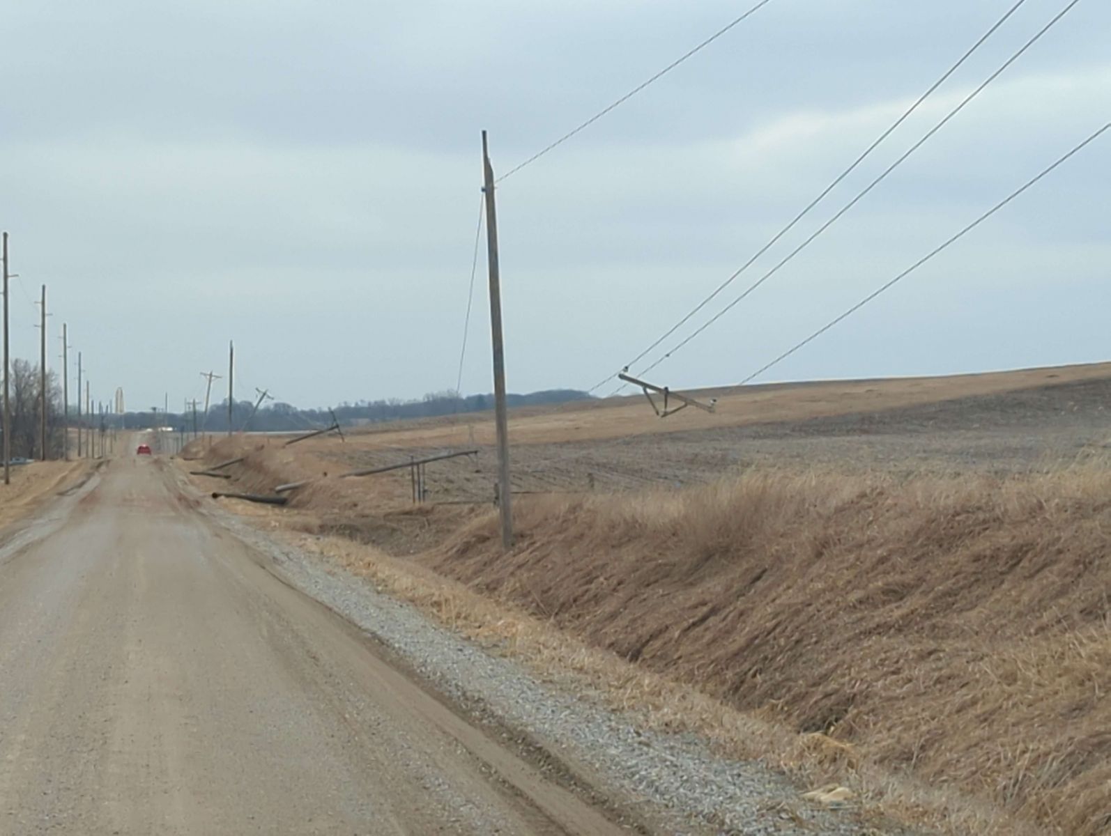
| Power pole damage and home damage east of Des Moines. Photo from NWS storm survey. | Power pole damage near Colfax. Photo from NWS storm survey. | Home damage on the north side of Newton. Photo from NWS storm survey. |
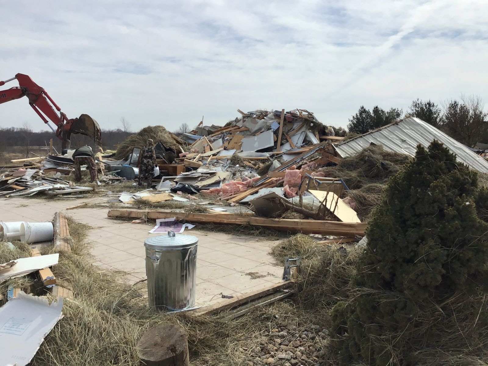
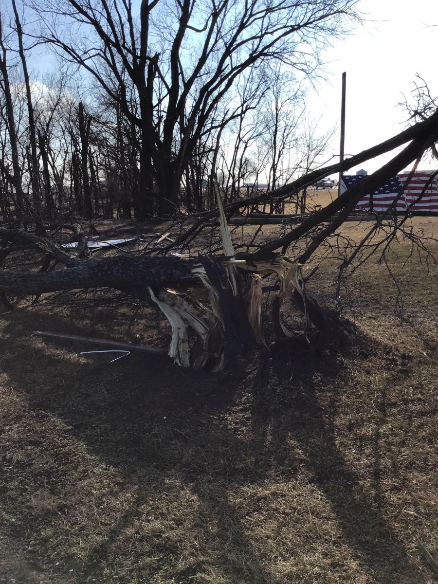
Chariton and Chariton Satellite Tornadoes
 |
 |
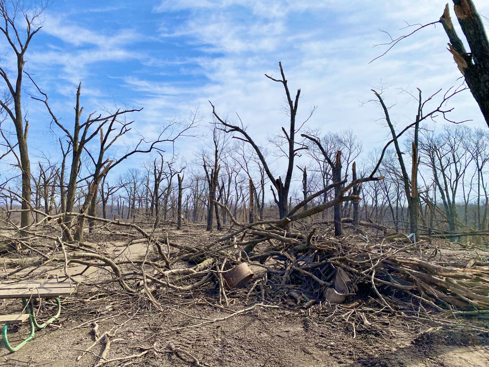 |
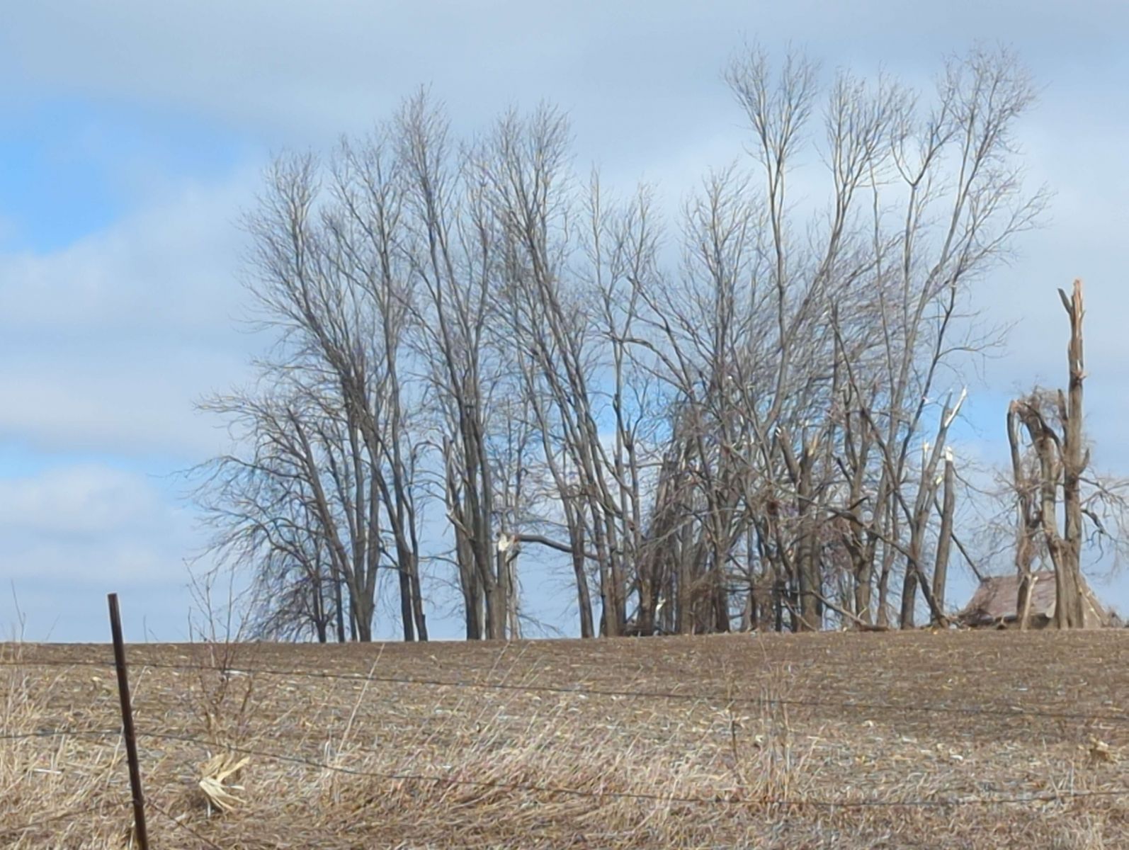
| Damage to the Pin Oak Lodge in Chariton. Photo from NWS damage survey. | Splintered tree in Chariton. Photo from NWS damage survey. | Extensive tree damage at Red haw State Park in Chariton. Photo from NWS damage survey. |
Footage of the Chariton satellite tornado merging with the main Chariton tornado. Courtesy of Nathan Moore.
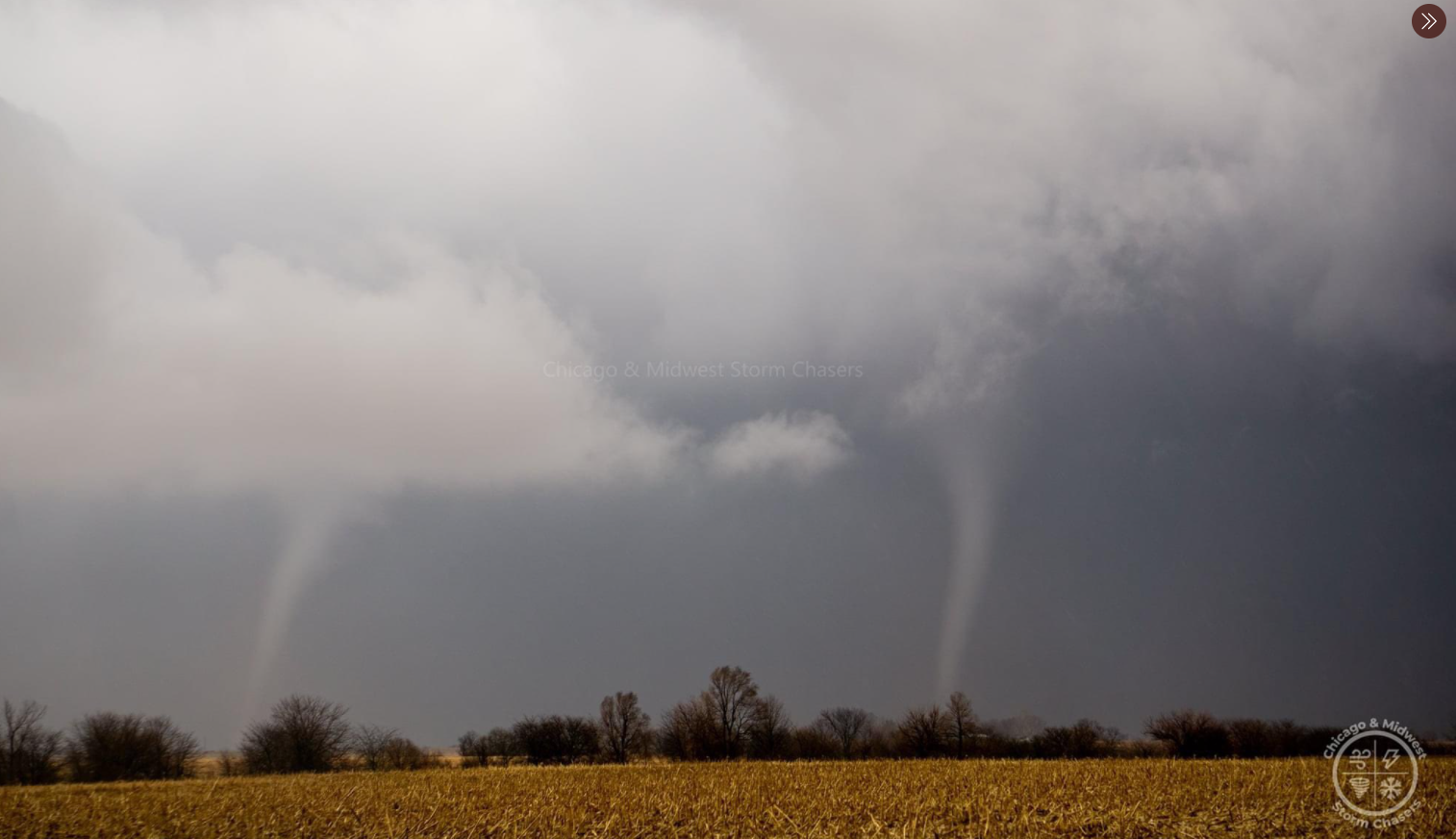
Garden Grove to Humeston and Derby Tornadoes
 |
 |
 |
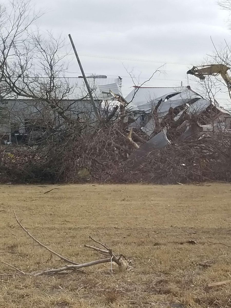
| Twin tornadoes near Humeston/Derby. Photo courtesy of Chicago Midwest Storm Chasers. | Destruction of an outbuilding near Derby. Photo from NWS damage survey. | Complete removal of roof on a home in Garden Grove. Photo from NWS damage survey. |
Twin tornadoes near Humeston and Derby. Courtesy of Nathan Moore.
Allerton to Corydon
 |
 |
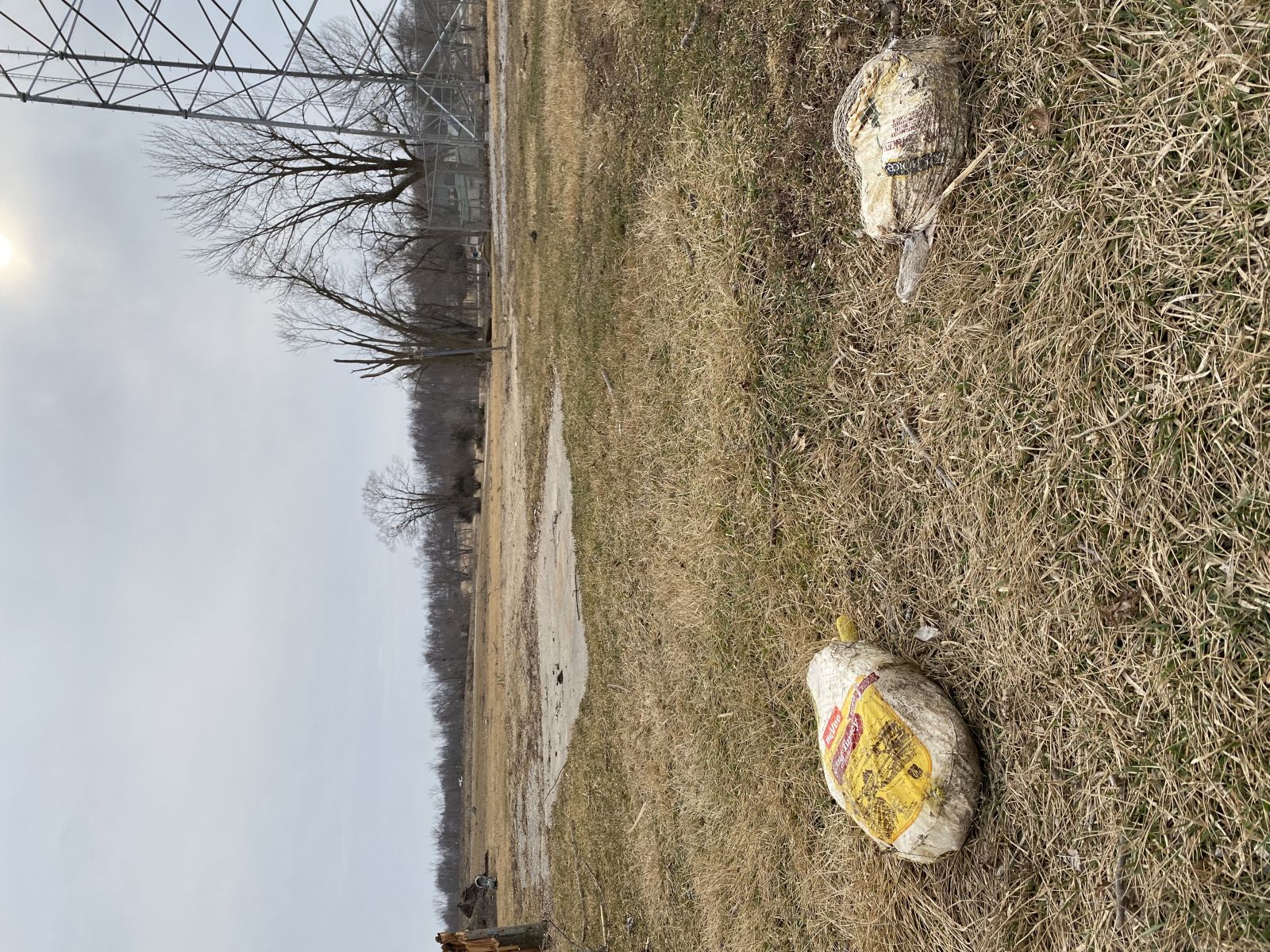 |
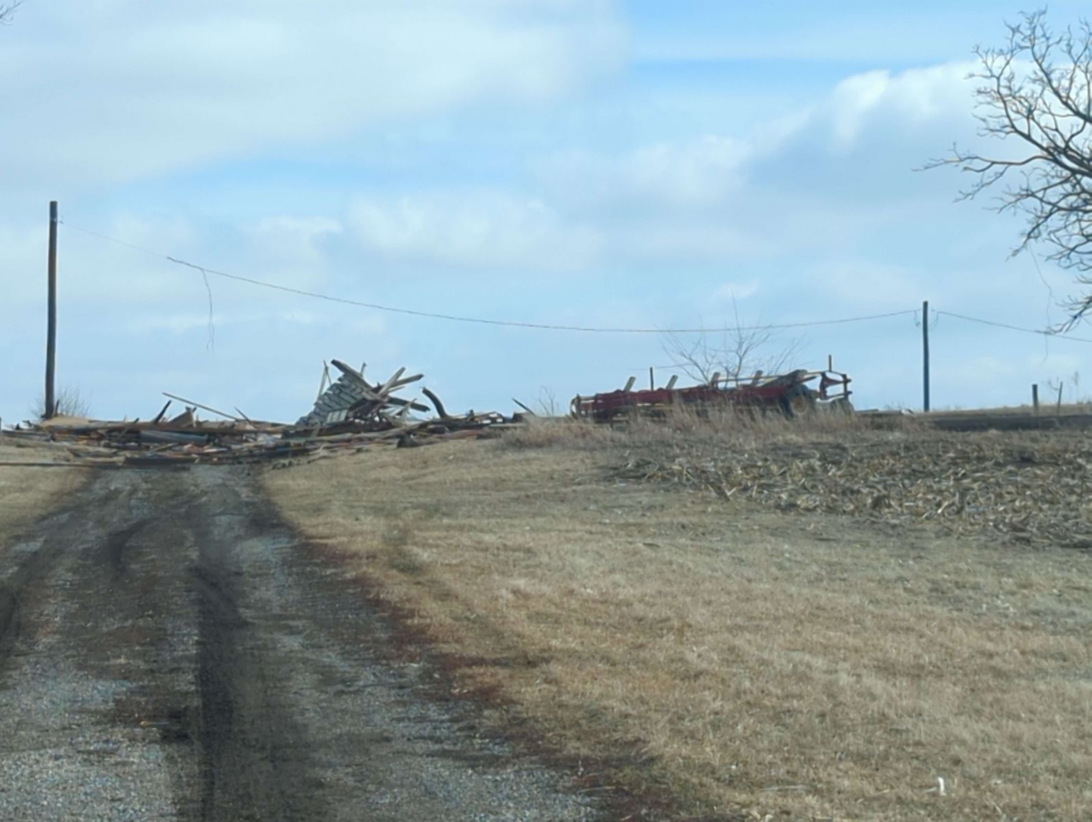
| Tornado near Corydon. Photo courtesy of twitter user @bambino2678 | Destruction of concession stand at Allerton baseball field. Photo from NWS damage survey. | Frozen turkeys found at the Allerton ballfield. These came from a home nearly half a mile from this location! Photo from NWS damage survey. |
Kellogg and Tama Tornadoes
 |
 |
 |
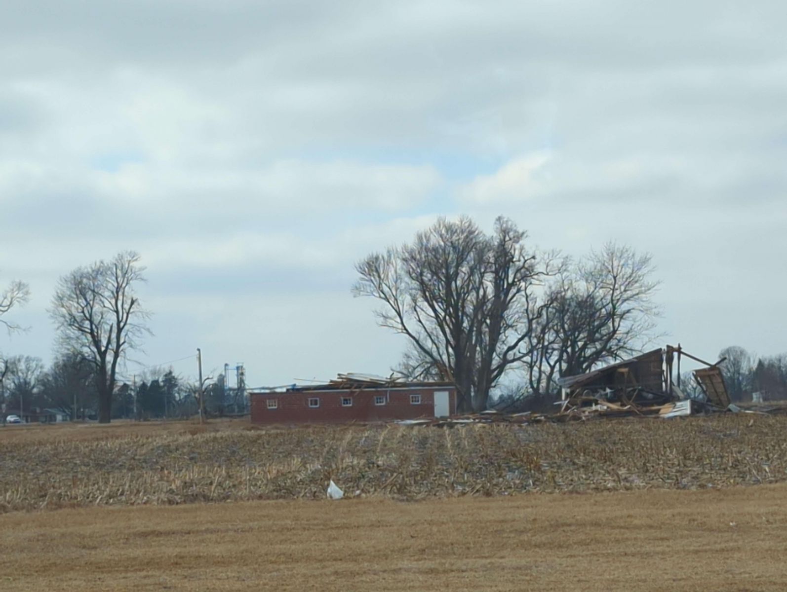
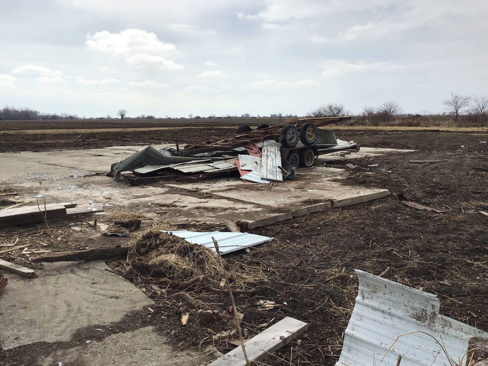
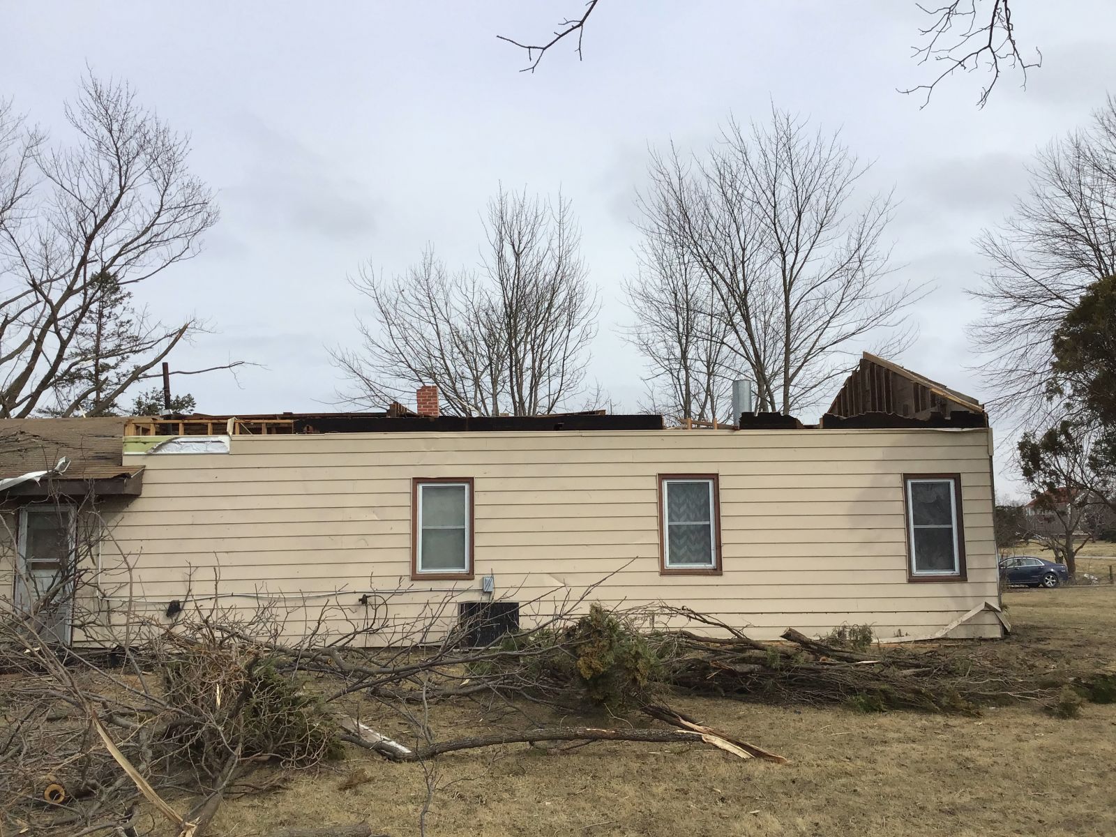
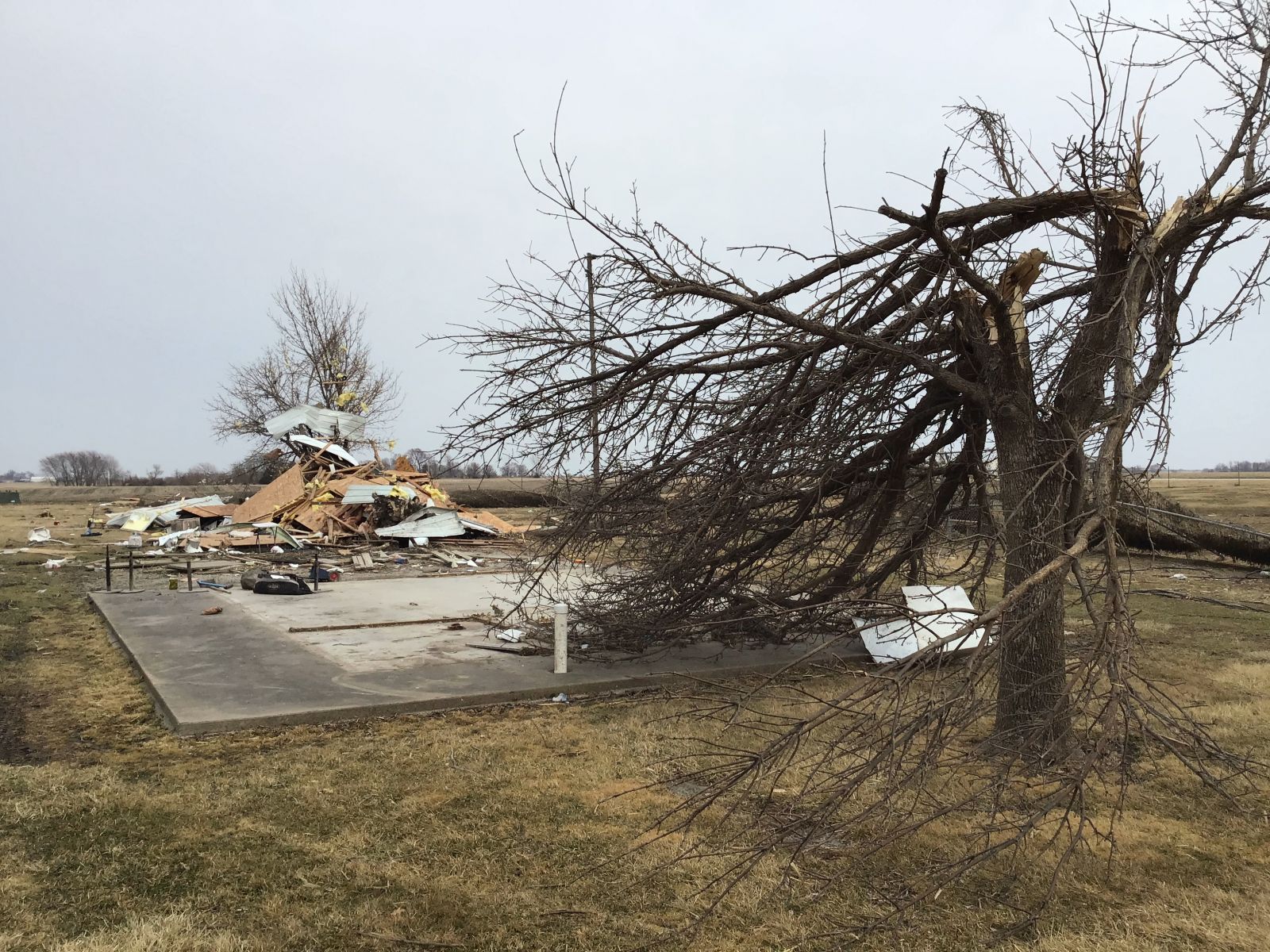
| Outbuilding detroyed north of Rock Creek State Park. Photo from NWS damage survey. | Tree damage north of Rock Creek State Park. Photo from NWS damage survey. | Home and vehicle damage south of Tama. Photo from NWS damage survey. |
Corning
Weak EF-Unknown tornado that developed near Corning. This same supercell would go on to produce the large EF-4 tornado. Courtesy of Nathan Moore.
 |
Media use of NWS Web News Stories is encouraged! Please acknowledge the NWS as the source of any news information accessed from this site. |
|