
Widespread life-threatening flash and urban flooding continues in south-central Texas, with considerable flooding impacts possible across central Texas. Wildfire smoke is impacting air quality across much of the Great Lakes region into southern New England and the Mid-Atlantic. Monsoonal thunderstorms may produce isolated to scattered flash flooding across the Southwest into the Great Basin. Read More >
Overview
|
During the afternoon and evening of Saturday, March 5th, a strong early spring low pressure system tracked through the Midwest. Storms developed during the afternoon in Iowa and produced multiple tornadoes before eventually merging into a quasi-linear convective system (QLCS) that moved eastward into northern Illinois by mid-evening. Multiple wind gusts of 70 mph or greater were noted across the NWS Chicago county warning area as this line of storms moved through, and even an 81 mph gust was observed at Rockford Airport. In addition to the storms, the low pressure system was also responsible for producing non-thunderstorm wind gusts in excess of 50 mph in some locations both before and after the line of storms rolled through the area. |
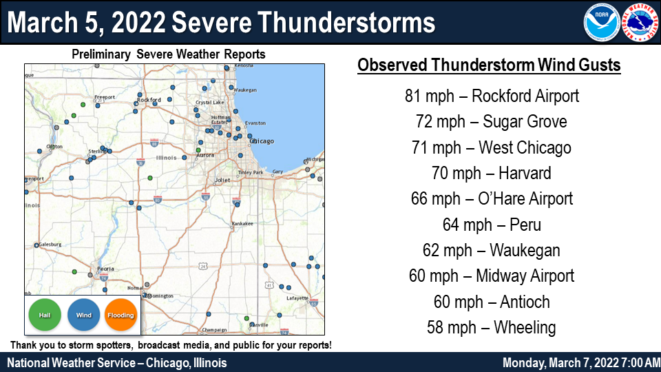 Event Summary Graphic |
Storm Reports
 |
| Map & List of Severe Thunderstorm Reports |
PRELIMINARY LOCAL STORM REPORT...SUMMARY
NATIONAL WEATHER SERVICE CHICAGO IL
818 AM CST MON MAR 7 2022

..TIME...   ...EVENT...      ...CITY LOCATION...     ...LAT.LON...
..DATE...   ....MAG....      ..COUNTY LOCATION..ST.. ...SOURCE....
            ..REMARKS..

0944 PM     TSTM WND GST     2 WNW DIXON             41.86N 89.52W
03/05/2022  M52 MPH          LEE                IL   EMERGENCY MNGR

            POWER FAILED AT TIME OF OBSERVATION.

0945 PM     TSTM WND DMG     DIXON                   41.84N 89.48W
03/05/2022                   LEE                IL   PUBLIC

            PHOTO SHARED ON SOCIAL MEDIA OF PART OF A
            FENCE BLOWN DOWN.

0948 PM     TSTM WND GST     3 ESE DIXON             41.83N 89.43W
03/05/2022  M66 MPH          LEE                IL   MESONET

            MESONET STATION UP060 DIXON 3 ESE (UP RAIL).

1006 PM     TSTM WND DMG     ROCKFORD                42.27N 89.09W
03/05/2022                   WINNEBAGO          IL   EMERGENCY MNGR

            TREE LIMBS AND POWER LINES WERE BLOWN DOWN IN ROCKFORD,
            ALONG WITH A FEW FULL TREES. DAMAGE WAS DESCRIBED AS
            SCATTERED.

1006 PM     TSTM WND GST     ROCKFORD AIRPORT        42.20N 89.10W
03/05/2022  M81 MPH          WINNEBAGO          IL   ASOS

            KRFD ASOS PEAK GUST.

1011 PM     TSTM WND DMG     MACHESNEY PARK          42.35N 89.04W
03/05/2022                   WINNEBAGO          IL   PUBLIC

            PHOTO SHARED ON SOCIAL MEDIA OF A TREE BLOWN DOWN,
            PARTIALLY ON A HOUSE.

1022 PM     TSTM WND DMG     1 NNW BELVIDERE         42.27N 88.85W
03/05/2022                   BOONE              IL   TRAINED SPOTTER

            TREE SNAPPED IN HALF. TIME ESTIMATED FROM
            RADAR.

1025 PM     TSTM WND GST     5 NW MARENGO            42.31N 88.66W
03/05/2022  M66 MPH          MCHENRY            IL   MESONET

            MESONET STATION IMC02 MARENGO 5 NW (MCHENRY
            DOT).

1025 PM     TSTM WND DMG     3 E GENOA               42.10N 88.63W
03/05/2022                   DE KALB            IL   TRAINED SPOTTER

            SEMI TRUCK BLOWN OVER ON ROUTE 72 EAST OF
            GENOA. TIME ESTIMATED FROM RADAR.

1033 PM     HAIL             1 ESE EARLVILLE         41.58N 88.91W
03/05/2022  U0.50 INCH       LA SALLE           IL   PUBLIC

            HALF-INCH HAIL REPORT FROM MPING.

1035 PM     TSTM WND GST     2 NW PERU               41.35N 89.15W
03/05/2022  M64 MPH          LA SALLE           IL   AWOS

            KVYS AWOS PEAK GUST.

1035 PM     TSTM WND GST     HARVARD                 42.42N 88.62W
03/05/2022  M70 MPH          MCHENRY            IL   MESONET

            PEAK GUST FROM WEATHERBUG STATION IN
            HARVARD.

1036 PM     TSTM WND DMG     OGLESBY                 41.30N 89.05W
03/05/2022                   LA SALLE           IL   BROADCAST MEDIA

            UTILITY POLES WERE DAMAGED NEAR WALNUT
            STREET AND PORTLAND AVENUE.

1044 PM     TSTM WND DMG     ALGONQUIN               42.16N 88.30W
03/05/2022                   MCHENRY            IL   PUBLIC

            8-INCH DIAMETER TREE LIMB DOWNED. TIME
            ESTIMATED FROM RADAR.

1045 PM     TSTM WND GST     2 S CRYSTAL LAKE        42.21N 88.32W
03/05/2022  M59 MPH          MCHENRY            IL   MESONET

            MESONET STATION IMC03 CRYSTAL LAKE (MCHENRY
            DOT).

1045 PM     TSTM WND GST     1 WNW SUGAR GROVE       41.77N 88.47W
03/05/2022  M72 MPH          KANE               IL   ASOS

            KARR ASOS PEAK GUST.

1054 PM     TSTM WND DMG     PISTAKEE HIGHLANDS      42.41N 88.21W
03/05/2022                   MCHENRY            IL   PUBLIC

            TWO TREES DOWNED, ONE ONTO A SHED. TIME
            ESTIMATED FROM RADAR.

1055 PM     TSTM WND GST     DUPAGE AIRPORT          41.91N 88.26W
03/05/2022  M71 MPH          DUPAGE             IL   ASOS

            KDPA ASOS PEAK GUST.

1057 PM     HAIL             1 ESE BATAVIA           41.84N 88.29W
03/05/2022  E0.70 INCH       KANE               IL   TRAINED SPOTTER

            PEA TO DIME SIZE HAIL ESTIMATED.

1100 PM     TSTM WND GST     ANTIOCH                 42.48N 88.10W
03/05/2022  M60 MPH          LAKE               IL   MESONET

            MEASURED ON PERSONAL WEATHER STATION.

1105 PM     TSTM WND DMG     STREAMWOOD              42.02N 88.17W
03/05/2022                   COOK               IL   PUBLIC

            MULTIPLE TREES UPROOTED IN STREAMWOOD. TIME
            ESTIMATED FROM RADAR.

1107 PM     TSTM WND DMG     2 W SCHAUMBURG          42.02N 88.12W
03/05/2022                   COOK               IL   NWS EMPLOYEE

            TREE UPROOTED AND SEVERAL LARGE TREE LIMBS
            DOWNED. TIME ESTIMATED FROM RADAR.

1111 PM     TSTM WND GST     2 SE WHEELING           42.12N 87.90W
03/05/2022  M58 MPH          COOK               IL   ASOS

            KPWK ASOS PEAK GUST.

1112 PM     TSTM WND GST     1 SW BEACH PARK         42.42N 87.87W
03/05/2022  M62 MPH          LAKE               IL   ASOS

            KUGN ASOS PEAK GUST.

1113 PM     TSTM WND GST     CHICAGO - O'HARE AIRPOR 41.98N 87.90W
03/05/2022  M66 MPH          COOK               IL   ASOS

            KORD ASOS PEAK GUST.

1114 PM     TSTM WND GST     ELK GROVE VILLAGE       42.00N 88.01W
03/05/2022  E60 MPH          COOK               IL   TRAINED SPOTTER

            ESTIMATED 50-60 MPH WIND GUSTS IN ELK GROVE
            VILLAGE.

1117 PM     TSTM WND DMG     1 NNW DUNNING - CHICAGO 41.95N 87.81W
03/05/2022                   COOK               IL   PUBLIC

            PHOTO SHARED ON SOCIAL MEDIA SHOWING PART OF
            AN APARTMENT COMPLEX ROOF PEELED BACK. TIME
            ESTIMATED FROM RADAR.

1120 PM     TSTM WND DMG     MORTON GROVE            42.04N 87.78W
03/05/2022                   COOK               IL   BROADCAST MEDIA

            LARGE TREE LIMB DOWNED ONTO ROAD. TIME
            ESTIMATED FROM RADAR.

1121 PM     TSTM WND GST     HIGHWOOD                42.20N 87.81W
03/05/2022  E60 MPH          LAKE               IL   TRAINED SPOTTER

            ESTIMATED PEAK WIND GUST.

1122 PM     TSTM WND DMG     1 N PORTAGE PARK - CHIC 41.97N 87.76W
03/05/2022                   COOK               IL   TRAINED SPOTTER

            LARGE TREE LIMB DOWNED. TIME ESTIMATED BY
            RADAR.

1126 PM     TSTM WND GST     MIDWAY AIRPORT          41.79N 87.75W
03/05/2022  M60 MPH          COOK               IL   ASOS

            KMDW ASOS PEAK GUST.

1132 PM     MARINE TSTM WIND 1 NE MONTROSE HARBOR    41.97N 87.63W
03/05/2022  M62 MPH          LMZ741             IL   MESONET

            MESONET STATION XMTB MONTROSE BEACH LIGHT.

1134 PM     MARINE TSTM WIND HARRISON-DEVER CRIB     41.92N 87.57W
03/05/2022  M61 MPH          LMZ741             IL   C-MAN STATION

            PEAK GUST AT HARRISON-DEVER CRIB.

1200 AM     TSTM WND GST     PEOTONE                 41.33N 87.79W
03/06/2022  M53 MPH          WILL               IL   MESONET

            MESONET STATION CW7762 PEOTONE.

1237 AM     TSTM WND GST     3 NNE OXFORD            40.56N 87.22W
03/06/2022  M56 MPH          BENTON             IN   MESONET

            PEAK GUST VIA DAVIS WEATHER STATION.

1239 AM     TSTM WND GST     1 SE KENTLAND           40.76N 87.43W
03/06/2022  M61 MPH          NEWTON             IN   MESONET

            PEAK GUST AT KENTLAND AIRPORT.

1245 AM     TSTM WND GST     4 NNW OTTERBEIN         40.55N 87.13W
03/06/2022  M59 MPH          BENTON             IN   MESONET

            PEAK GUST VIA DAVIS WEATHER STATION.
Non-Thunderstorm Wind Gusts
Below is a sampling of peak wind gusts from the evening and overnight hours
of March 5th into March 6th that were observed outside of any thunderstorms.

Location                                   Peak Gust   Source

Rockford Airport.............................63 mph    ASOS
Deerfield....................................63 mph    Mesonet
Harrison-Dever Crib..........................62 mph    C-Man Station
East Chicago.................................58 mph    Mesonet
Michigan City Lighthouse.....................57 mph    C-Man Station
Calumet Harbor...............................56 mph    Buoy
Herbert 5 ENE................................56 mph    Mesonet
Midway Airport 3 SW..........................56 mph    COOP Observer
Waukegan Airport.............................55 mph    ASOS
Aurora Municipal Airport (Sugar Grove).......55 mph    ASOS
Chicago - Midway Airport.....................54 mph    ASOS
Valparaiso Airport...........................53 mph    ASOS
Chicago Executive Airport (Wheeling).........52 mph    ASOS
Chicago - O'Hare Airport.....................51 mph    ASOS
DuPage Airport (West Chicago)................51 mph    ASOS
Homer Glen...................................51 mph    Trained Spotter
Sycamore.....................................49 mph    Mesonet
McHenry......................................49 mph    Mesonet
Harvard 4 NW.................................48 mph    Mesonet
DeKalb Airport...............................47 mph    AWOS
Crown Point..................................47 mph    Mesonet
Elmhurst.....................................46 mph    Mesonet
Lansing Airport..............................45 mph    AWOS
Lewis University Airport (Romeoville)........45 mph    AWOS
Palatine.....................................45 mph    Mesonet
Radar
 |
| Click here for an interactive version of this radar loop (courtesy of the Iowa Environmental Mesonet) |
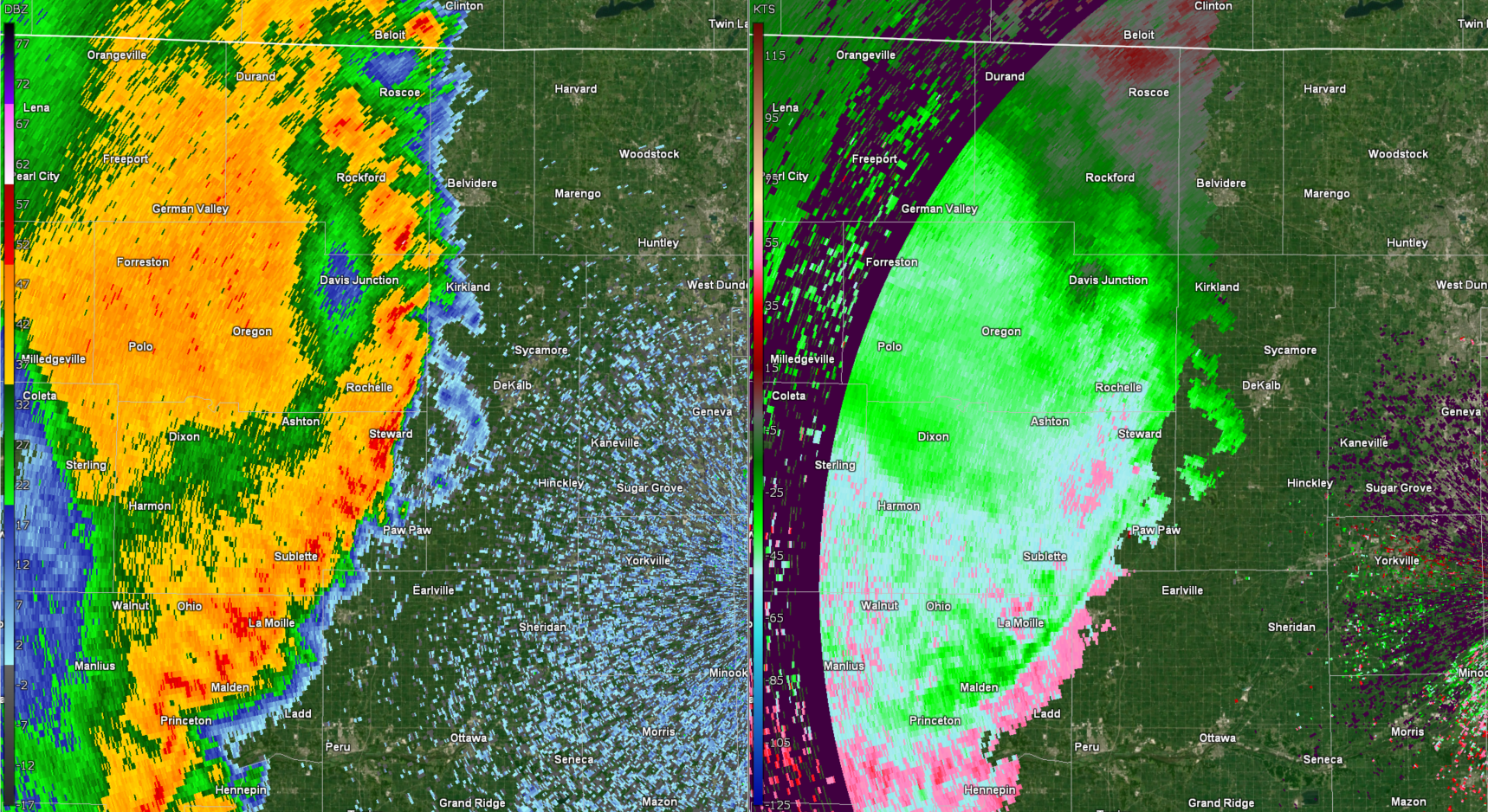 |
| A 10:07 P.M. radar image of base reflectivity (left) and base velocity (right). The radar is sampling at this lowest angle about 7,000-8,000 ft above ground layer over the Rockford area, where an 81 mph measured gust occurred at the Airport with the storms at this time. Note the quasi-linear look to the well-organized storms in the reflectivity, as well as pockets of lower reflectivity (drying/descending motion) in the immediate wake of this front line. These are all signatures of high thunderstorm wind speeds. Indeed, the velocity shows high speeds of over 50 kt (58 mph) that are inbound toward the radar. |
Environment
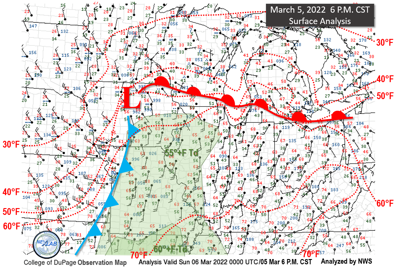 |
| This surface analysis from the early evening of Saturday, March 5, depicts a classic signature for severe weather, especially in Iowa, but that also extended into northern Illinois. The deep low pressure, around 997 mb at this time, was deepening as it moved northeast. This track and trend in the low pressure also resulted in gusty southerly winds ahead of the low drawing low-level moisture northward. These winds remained gusty after dark into the evening and continued to keep the air both warm and moist. This limited any "capping" of the atmosphere that can commonly occur after dark, and allowed the well-organized storms ahead of the cold front tracking out of Iowa later that evening to continue a severe wind threat into and across northern Illinois. |
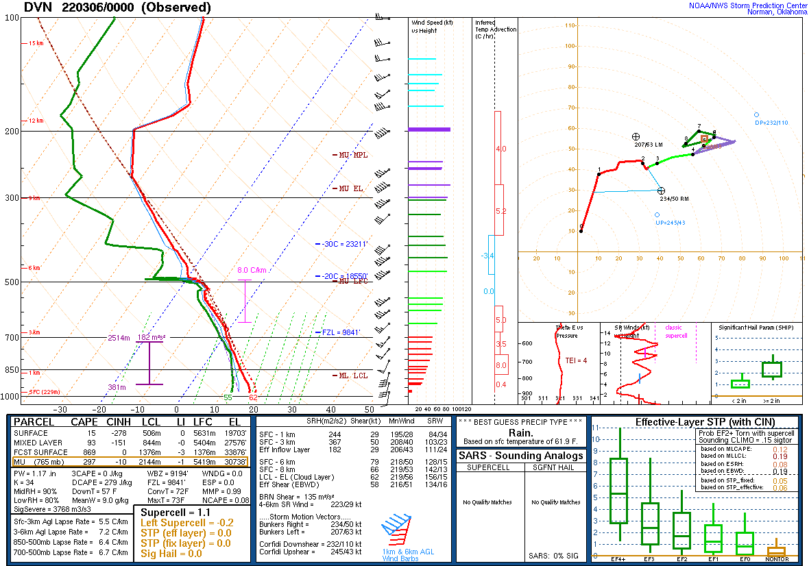 |
| This is a weather balloon plot, or sounding, from the NWS Quad Cities office from 6 PM CST on the evening of March 5th. This shows a highly anomalous moist atmosphere for early March, with precipitable water (PW) values of 1.17 inches being around record high for the time of year. The moist and warm plot in the low-levels provided instability from the surface, meaning that air parcels would rise from the surface. This sounding also showed a lack of a strong "cap" to suppress thunderstorm development. All this indicated a likelihood of severe winds with an organized thunderstorm complex, as well as a non-zero tornado threat, continuing into northern Illinois, especially considering the very high values of low-level shear and storm-relative helicity (SRH). |
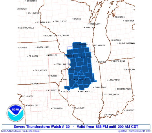 |
| Because of the environment as shown above, and existing severe storms in Iowa, a Severe Thunderstorm Watch was issued by the NWS Storm Prediction Center (SPC) around 8:35 P.M. CST for northwest and north central Illinois, including parts of the western Chicago metro. This Watch would later be locally expanded to include the rest of the metro as storms continued east. The main threat of the storms was evolving from tornadoes in Iowa to more of a severe wind threat into northern Illinois, based on the storm mode being more quasi-linear than supercellular by that point in the evening. |
Additional Info
 |
Media use of NWS Web News Stories is encouraged! Please acknowledge the NWS as the source of any news information accessed from this site. Additional recaps can be found on the NWS Chicago Past Events Page |
|

