Wildfire smoke will push into the Midwest, worsening air quality. A frontal system brings severe storms from the Northern Plains to the Mid‑Atlantic the next few days. Heavy Gulf Coast rain is possible as Tropical Depression Two has formed, while monsoonal storms persist in the Southwest with heavy rainfall. Hazardous heat expands from the Plains into the Lower Mississippi Valley. Read More >
Overview
|
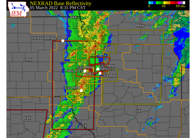
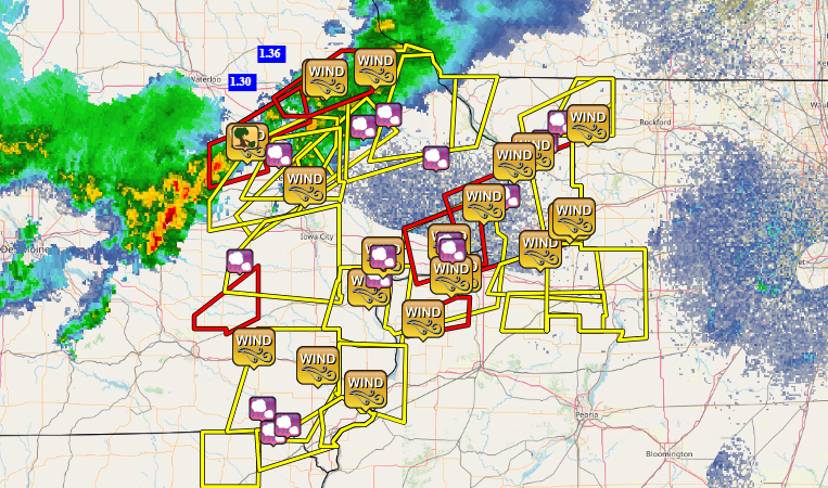
Severe thunderstorms tracked across all of eastern Iowa, northwest Illinois and far northeast Missouri during the late afternoon and evening of Saturday March 5, 2022. Thunderstorms initially developed in southwest Iowa, and moved across central Iowa during the afternoon hours before reaching our area after 600 PM. Initially, storms produced large hail and tornadoes over central Iowa, before the threat evolved more into damaging winds and tornadoes as storms moved into eastern Iowa and northwest Illinois. Winds around 60-75 MPH were reported from trained spotters and first responders, with confirmed reports of damage in some locations.
Surrounding Office Summaries |
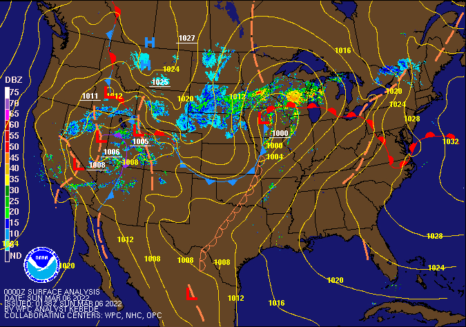
Surface Analysis (Courtesy of the Weather prediction Center) |
Tornadoes
|
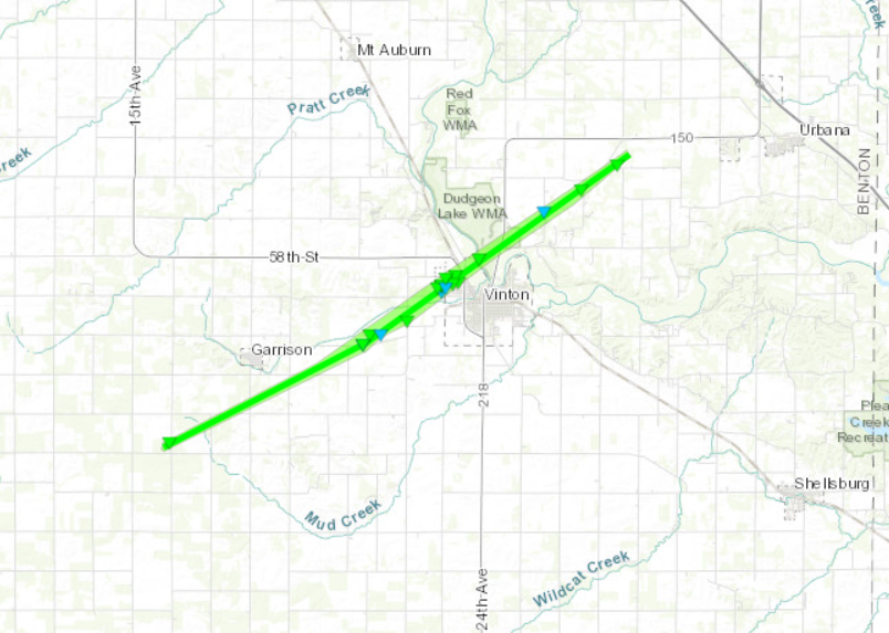
Vinton, Iowa
|
||||||||||||||||
|
|
||||||||||||||||
|
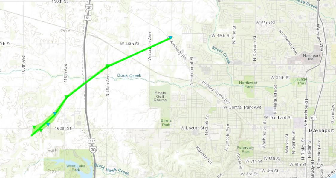
3 W Davenport, Iowa
|
||||||||||||||||
|
|
||||||||||||||||
|
Erie, Illinois
|
||||||||||||||||
|
|
||||||||||||||||
The Enhanced Fujita (EF) Scale classifies tornadoes into the following categories:
| EF0 Weak 65-85 mph |
EF1 Moderate 86-110 mph |
EF2 Significant 111-135 mph |
EF3 Severe 136-165 mph |
EF4 Extreme 166-200 mph |
EF5 Catastrophic 200+ mph |
 |
|||||
Storm Reports
| Interactive Storm Report Map (IEM) | SPC Storm Reports |
 |
 |
PRELIMINARY LOCAL STORM REPORT...SUMMARY
NATIONAL WEATHER SERVICE QUAD CITIES IA IL
958 PM CST SAT MAR 5 2022

..TIME...   ...EVENT...      ...CITY LOCATION...     ...LAT.LON...
..DATE...   ....MAG....      ..COUNTY LOCATION..ST.. ...SOURCE....
            ..REMARKS..

1226 PM     HAIL             MAQUOKETA               42.07N 90.67W
03/05/2022  E0.25 INCH       JACKSON            IA   PUBLIC

            DELAYED REPORT VIA SOCIAL MEDIA.

0600 PM     HEAVY RAIN       JESUP                   42.48N 92.07W
03/05/2022  M1.30 INCH       BUCHANAN           IA   PUBLIC

            DELAYED REPORT.

0612 PM     HAIL             FULTON                  41.87N 90.16W
03/05/2022  E0.25 INCH       WHITESIDE          IL   PUBLIC

            DELAYED REPORT VIA SOCIAL MEDIA.

0621 PM     HAIL             5 NW LANARK             42.16N 89.89W
03/05/2022  E0.50 INCH       CARROLL            IL   TRAINED SPOTTER

            HAIL BEGAN 621 PM AND ENDING AT 629 PM.
            COVERED THE GROUND.

0632 PM     HAIL             2 WNW BOLTON            42.26N 89.77W
03/05/2022  M0.25 INCH       STEPHENSON         IL   TRAINED SPOTTER

            PEA SIZED HAIL WITH A HEAVY DOWNPOURS.

0718 PM     TSTM WND GST     1 S VINTON              42.15N 92.03W
03/05/2022  E70 MPH          BENTON             IA   BROADCAST MEDIA

            ESTIMATED 60-70 MPH WINDS.

0719 PM     TSTM WND DMG     1 NW VINTON             42.18N 92.04W
03/05/2022                   BENTON             IA   EMERGENCY MNGR

            DAMAGE TO STRUCTURES AND GAS LEAKS REPORTED
            BY EMERGENCY MANAGEMENT IN THE NORTHWEST
            SIDE OF VINTON. POSSIBLE TORNADO. TIME
            ESTIMATED FROM RADAR.

0723 PM     TSTM WND GST     4 NNW ELY               41.92N 91.61W
03/05/2022  M60 MPH          LINN               IA   TRAINED SPOTTER

            MEASURED.

0735 PM     TSTM WND GST     FAIRFIELD MUNICIPALITY  41.05N 91.98W
03/05/2022  M64 MPH          JEFFERSON          IA   AWOS

            IADOT AWOS.

0736 PM     HAIL             NORTH ENGLISH           41.52N 92.08W
03/05/2022  E0.75 INCH       IOWA               IA   PUBLIC

            OCCURRING RIGHT NOW.

0751 PM     HAIL             3 ESE KEOSAUQUA         40.72N 91.92W
03/05/2022  E0.70 INCH       VAN BUREN          IA   TRAINED SPOTTER

            OCCURRING RIGHT NOW.

0753 PM     HAIL             MONTICELLO              42.24N 91.19W
03/05/2022  E1.00 INCH       JONES              IA   TRAINED SPOTTER


0803 PM     HAIL             2 N PALO                42.09N 91.80W
03/05/2022  E0.75 INCH       LINN               IA   EMERGENCY MNGR

            OCCURRING RIGHT NOW ALONG WITH HEAVY RAIN.

0805 PM     TSTM WND GST     1 W MANCHESTER          42.49N 91.48W
03/05/2022  M55 MPH          DELAWARE           IA   EMERGENCY MNGR


0806 PM     TSTM WND GST     MANCHESTER              42.49N 91.46W
03/05/2022  M55 MPH          DELAWARE           IA   EMERGENCY MNGR


0810 PM     HAIL             3 ENE CHARLIE HEATH MEM 40.59N 91.84W
03/05/2022  M0.50 INCH       CLARK              MO   TRAINED SPOTTER

            ALSO WINDS AROUND 50 MPH.

0810 PM     TSTM WND GST     MOUNT PLEASANT MUNICIPA 40.95N 91.52W
03/05/2022  M56 MPH          HENRY              IA   AWOS

            IADOT AWOS.

0812 PM     TSTM WND GST     NEW VIENNA              42.55N 91.11W
03/05/2022  M65 MPH          DUBUQUE            IA   FIRE DEPT/RESCUE


0813 PM     HAIL             FARMINGTON              40.63N 91.74W
03/05/2022  M0.25 INCH       VAN BUREN          IA   TRAINED SPOTTER

            ALSO WIND GUSTS TO 43 MPH.

0815 PM     TSTM WND GST     MUSCATINE MUNICIPALITY  41.37N 91.15W
03/05/2022  M56 MPH          MUSCATINE          IA   AWOS

            IADOT AWOS.

0817 PM     HAIL             CASCADE                 42.30N 91.01W
03/05/2022  E0.25 INCH       DUBUQUE            IA   TRAINED SPOTTER


0817 PM     HAIL             CASCADE                 42.30N 91.01W
03/05/2022  E0.25 INCH       DUBUQUE            IA   TRAINED SPOTTER


0818 PM     HAIL             4 SSE MOSCOW            41.54N 91.05W
03/05/2022  E0.25 INCH       MUSCATINE          IA   AMATEUR RADIO


0820 PM     HAIL             2 NNW MUSCATINE         41.44N 91.08W
03/05/2022  E0.25 INCH       MUSCATINE          IA   TRAINED SPOTTER


0822 PM     TSTM WND GST     4 SSE MOSCOW            41.54N 91.05W
03/05/2022  E65 MPH          MUSCATINE          IA   AMATEUR RADIO


0822 PM     HAIL             4 SSE MOSCOW            41.54N 91.05W
03/05/2022  E1.00 INCH       MUSCATINE          IA   AMATEUR RADIO


0831 PM     HEAVY RAIN       2 ENE HAZLETON          42.63N 91.86W
03/05/2022  M1.36 INCH       BUCHANAN           IA   CO-OP OBSERVER

            IN THE PAST 12 HOURS.

0844 PM     TSTM WND GST     WEST BURLINGTON         40.82N 91.18W
03/05/2022  E50 MPH          DES MOINES         IA   TRAINED SPOTTER

            ESTIMATED 45-55 MPH WINDS NEAR THE HOSPITAL.

0846 PM     TSTM WND GST     DAVENPORT MUNICIPALITY  41.61N 90.58W
03/05/2022  M62 MPH          SCOTT              IA   OFFICIAL NWS OBS

            REPORTED ON RSOIS AT NWS OFFICE.

0847 PM     HAIL             DAVENPORT MUNICIPALITY  41.61N 90.58W
03/05/2022  E0.25 INCH       SCOTT              IA   NWS EMPLOYEE

            OCCURRING RIGHT NOW AT NWS OFFICE.

0848 PM     TSTM WND GST     MOLINE QUAD-CITY AIRPOR 41.45N 90.50W
03/05/2022  M64 MPH          ROCK ISLAND        IL   ASOS

            ASOS.

0850 PM     TSTM WND GST     MILAN                   41.44N 90.56W
03/05/2022  E60 MPH          ROCK ISLAND        IL   PUBLIC

            ALSO PEA SIZED HAIL.

0902 PM     TSTM WND GST     CLINTON MUNICIPALITY    41.83N 90.33W
03/05/2022  M64 MPH          CLINTON            IA   AWOS

            AWOS.

0903 PM     HAIL             3 S MOUNT JOY           41.58N 90.55W
03/05/2022  E0.50 INCH       SCOTT              IA   PUBLIC


0922 PM     TSTM WND GST     MOUNT CARROLL           42.10N 89.98W
03/05/2022  E65 MPH          CARROLL            IL   PUBLIC


0928 PM     TSTM WND GST     2 S LEON CORNERS        41.58N 89.92W
03/05/2022  M60 MPH          HENRY              IL   TRAINED SPOTTER

            FROM HAND-HELD ANEMOMETER.

0930 PM     NON-TSTM WND GST 2 SW WHITESIDE COUNTY A 41.73N 89.71W
03/05/2022  M56 MPH          WHITESIDE          IL   TRAINED SPOTTER


0934 PM     TSTM WND GST     WHITESIDE COUNTY AIRPOR 41.75N 89.68W
03/05/2022  M75 MPH          WHITESIDE          IL   AWOS

            AWOS.

0935 PM     NON-TSTM WND GST TRI-TOWNSHIP AIRPORT    42.05N 90.11W
03/05/2022  M61 MPH          CARROLL            IL   AWOS

            AWOS.
Rainfall Reports (more updates Sunday)
| Local Rainfall Analysis | Regional Rainfall Analysis |
 |
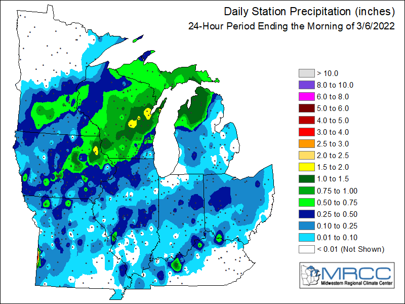 |
24 hour precipitation reports (in Inches),
for eastern Iowa, northwest and west central Illinois,
and northeast Missouri. Reported between Midnight and 9 AM,
Sunday March 06, 2022.

....IOWA....
Elkader 6SSW                     1.92
Strawberry Point                 1.28
Toledo 3 N                       0.89
Guttenberg Dam 10                0.87
Oelwein Arpt                     0.81
Mount Auburn 2.2 NNW             0.78
Waterloo Arpt                    0.77
Marshalltown 1 NW                0.73
Cedar Rapids Arpt                0.72
Dubuque Arpt                     0.72
Bellevue LD12                    0.61
Fayette 1 NW                     0.60
Cedar Rapids 2.7 NE              0.58
Center Point 0.6 NNW             0.58
Solon 0.3 ESE                    0.56
Dubuque LD11                     0.55
Ely 0.5 SE                       0.53
Marshalltown Arpt                0.53
Fairfield                        0.52
Rickardsville 0.2 W              0.51
Mason City 1 NNE                 0.50
Grinnell Arpt                    0.48
North Liberty 0.7 SSW            0.47
Marengo                          0.45
Newton 1 NE                      0.40
Iowa City                        0.40
Salem 1S                         0.40
Anamosa 3 SSW                    0.39
Williamsburg                     0.36
Wapello 0.2 S                    0.34
NWS Johnston* 5 NNW              0.34
Wapello 5.4 SE                   0.33
Mason City Arpt                  0.32
Park View 0.2 WSW                0.28
Davenport Arpt                   0.27
Marion 1.7 NNW                   0.26
Beaconsfield 1 NNE               0.26
Le Claire 1.8 NNE                0.25
Mt Pleasant 1 SSW                0.25
Burlington Arpt                  0.25
Hampton 1 N                      0.24
De Witt                          0.24
Muscatine 2N                     0.23
Wellman 4.0 E                    0.21
Davenport 0.9 WNW                0.21
Charlotte 1.9 WNW                0.21
Washington                       0.19
Pella Arpt                       0.17
Iowa City Arpt                   0.17
Donnellson                       0.14
Boone 1 SSW                      0.10
Ottumwa ASOS                     0.09
Oskaloosa Arpt                   0.08
Sigourney                        0.08
Ainsworth 7.4 N                  0.07
Burlington 6.5 SSW               0.06
Keokuk LD19                      0.05
Parnell 0.1 SSW                  0.00
Maquoketa                        0.00
....ILLINOIS....
Stockton 3.4 NNE                 1.05
Elizabeth                        0.52
Freeport 1.7 NW                  0.49
Ogden                            0.48
Ill. City LD16 3 WNW             0.47
Paw Paw 1 E                      0.45
Mount Carroll 6.8 NNW            0.43
Quad City Arpt                   0.43
Galesburg                        0.42
Winslow 4.3 ESE                  0.39
Altona                           0.39
Fulton LD13                      0.38
Geneseo 2.0 NW                   0.33
Decatur Airport                  0.33
Freeport 2.9 WSW                 0.32
Tuscola                          0.30
Aledo                            0.29
Freeport                         0.28
Mount Carroll                    0.28
Romeoville                       0.25
Rockford Arpt                    0.24
New Boston LD17                  0.23
Windsor                          0.23
New Windsor 2.0 N                0.22
Coal Valley 1.9 SE               0.22
Kewanee 1 E                      0.21
Stronghurst 0.4 SSW              0.20
Mundelein                        0.17
Joliet Arpt                      0.16
Gladstone LD18                   0.15
Steward                          0.13
Princeton 1.1 SE                 0.11
Princeton                        0.11
Augusta                          0.11
Rochelle Arpt                    0.08
Bentley                          0.04
Colchester 3.5 NE                0.01
Prairie City 2S                  0.01
Peoria Arpt                      0.01
Bloomington Airport              0.00
Lincoln NWS                      0.00
Quincy Arpt                      0.00
Jacksonville Arpt                0.00
St Anne                          0.00
....MISSOURI....
Kirksville Arpt                  0.18
Chillicothe Arpt                 0.12
Columbia Arpt                    0.11
....WISCONSIN....
Prairie du Chien Arpt            1.31
Madison Arpt                     1.18
Steuben 4SE 3 NE                 1.13
Monroe 1 W                       0.97
La Crosse WFO                    0.83
Viroqua                          0.74
Brodhead 1 SW                    0.73
Darlington                       0.73
Watertown-Arpt                   0.53
Allenton-WWTP .6 NW              0.48
Whitewater                       0.44
Sullivan-NWS 2 SE                0.37
Beloit-College                   0.25
Delavan-1 W-WWTP 1 W             0.25
....MINNESOTA....
Preston                          0.71
Theilman 1SSW                    0.24
Environment
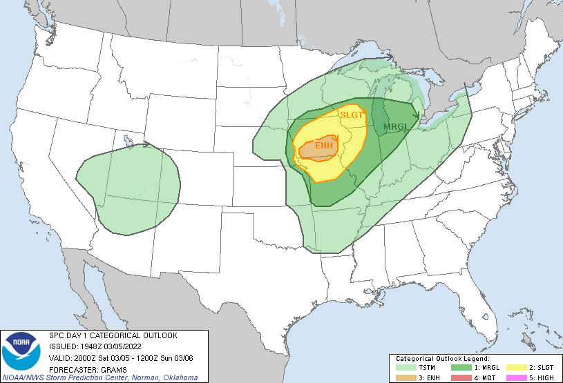
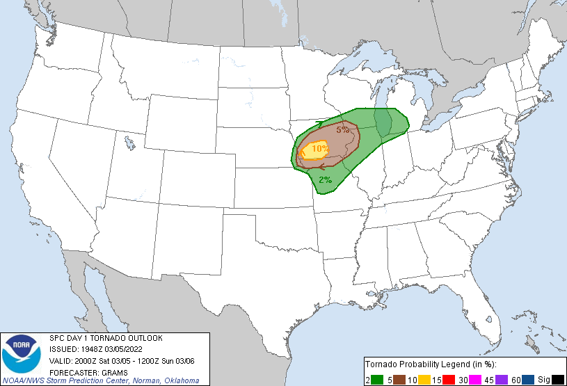
SPC EVENT REVIEW PAGE: 03/05/2022
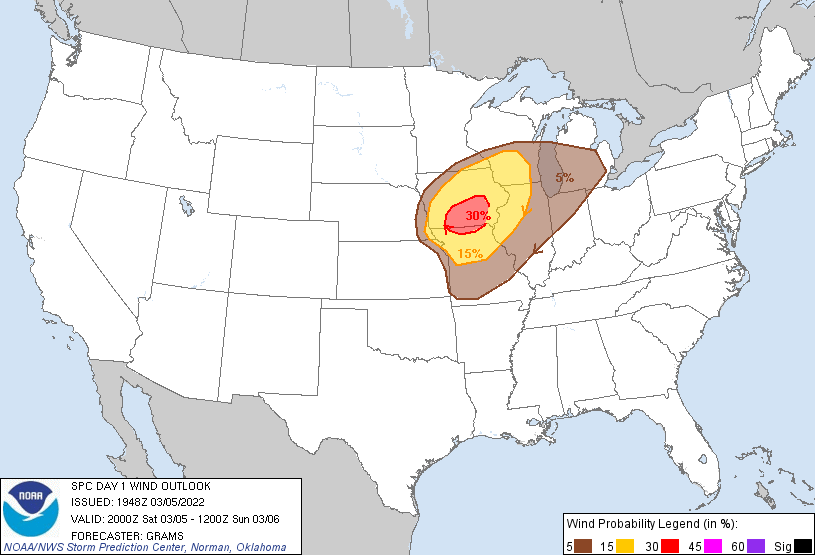
SPC Categorical/Tornado/Hail/Wind Outlooks
 |
 |
 |
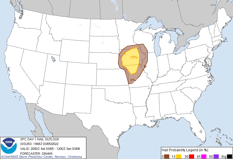 |
| SPC Categorical Outlook | Tornado Outlook | Wind Outlook | Hail Outlook |
DVN Observed Sounding Analysis
 |
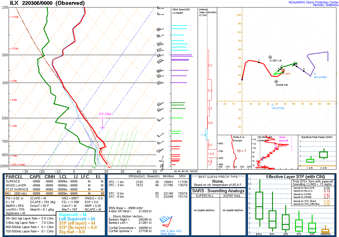 |
| 600 PM DAVENPORT, IA SOUNDING | 600 PM LINCOLN, IL SOUNDING |
SPC Mesoscale Discussions
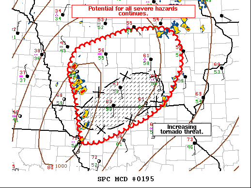  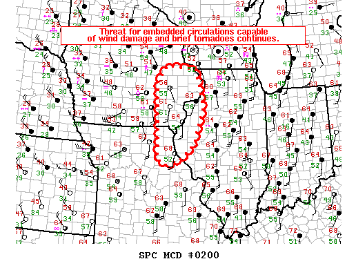 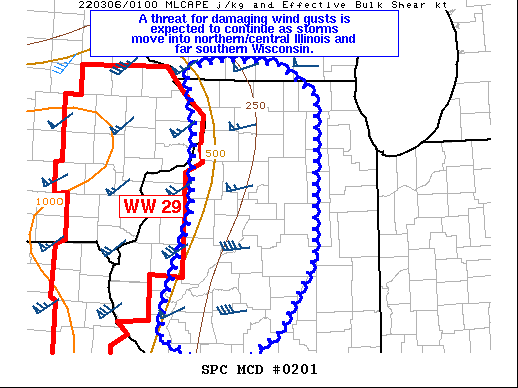 |
| MCD 0195, 0197, 0200, and 0201 |
SPC Convective Watches
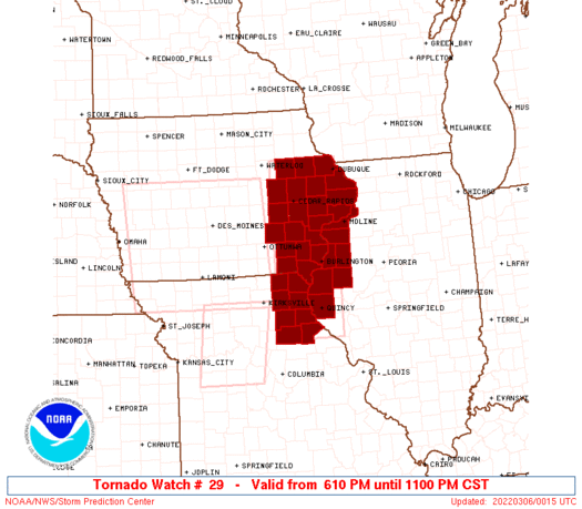 |
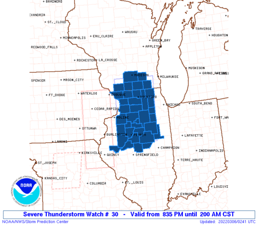 |
| Severe Thunderstorm Watch #29 | Severe Thunderstorm Watch #30 |
Additional Information
 |
Media use of NWS Web News Stories is encouraged! Please acknowledge the NWS as the source of any news information accessed from this site. |
|