| NOTE: Reload/refresh this page manually to display the most recent information. |
Situational Awareness Monitoring Links |
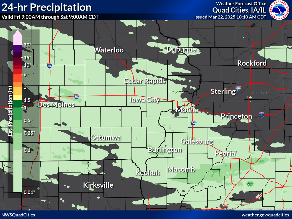
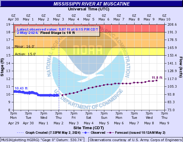
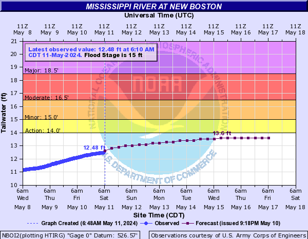
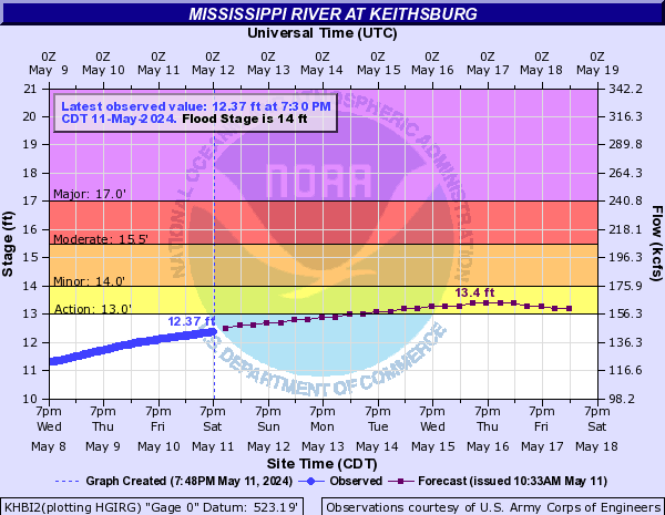
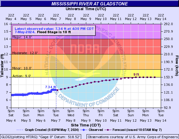
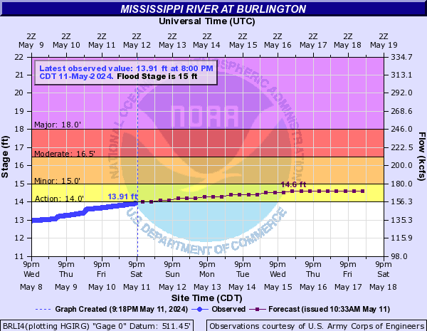
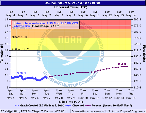
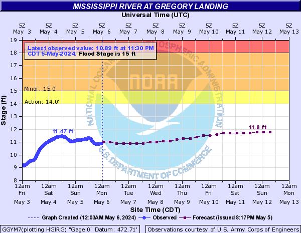
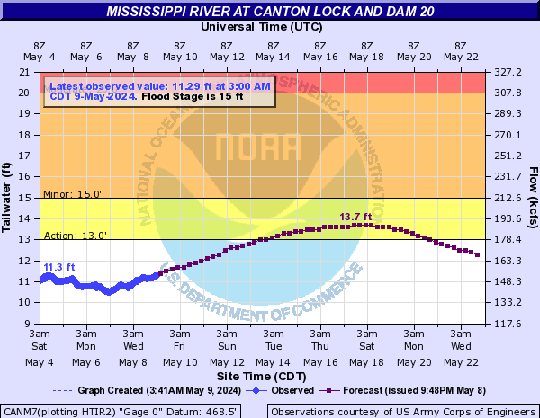
Current Conditions
|
|||||||||||||||||||||||||||||||||||||||||||||||||||||||||||||||||||||||||||||||||||||||||||||||||||||||||||||||||||||||||||||||||||||||||||||||||||||||||||||||||||||||||||
Forecast Overview
|
|||||||||||||||||||||||||||||||||||||||||||||||||||||||||||||||
| Overview | |||||||||||
|
|||||||||||
|
|
|||||||||||
| Hazardous Weather Outlook | |||||||||||
| Technical Forecast Discussion | |||||||||||
| Medium-Range Outlooks | |||||||||||
|
|||||||||||
| Additional Resources | |||||||||||
|
|||||||||||
|
|
|||||||||||
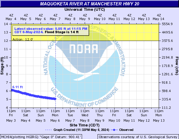
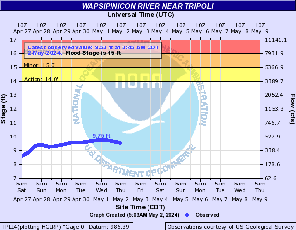
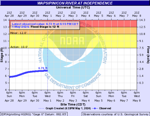
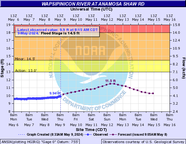
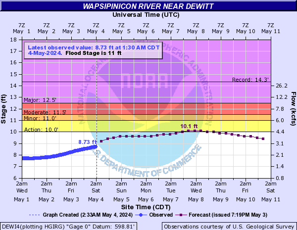
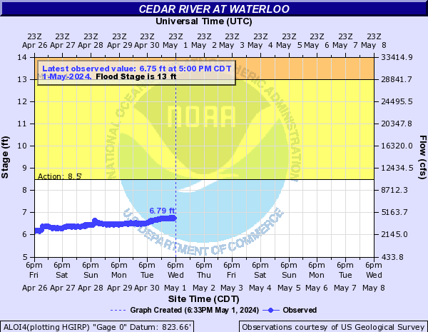
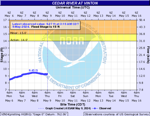
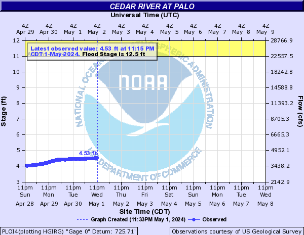
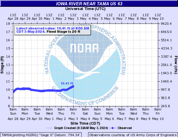
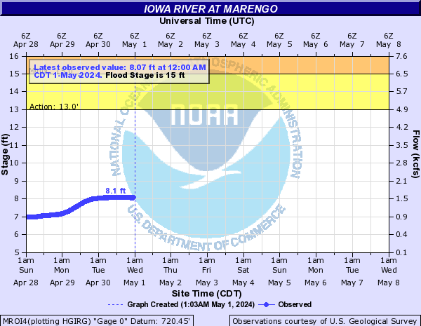
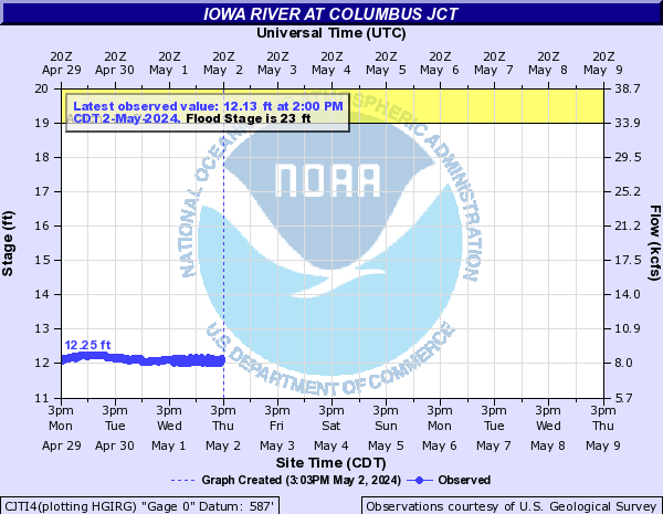
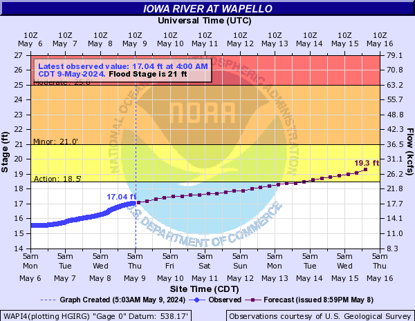
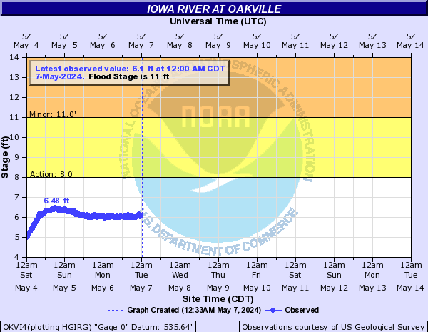
| Iowa River - Create your own custom page for the Iowa River | |||||||||||||||
|
|||||||||||||||
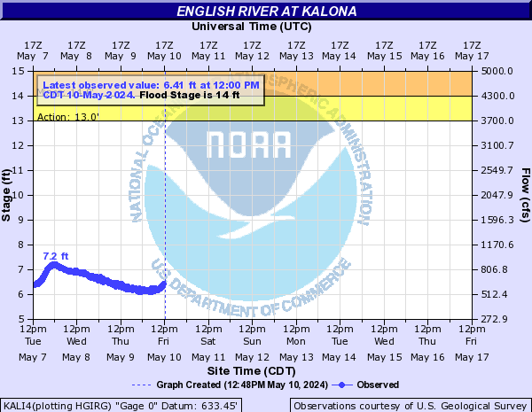
| English River - Create your own custom page for the English River | |||
|
|||
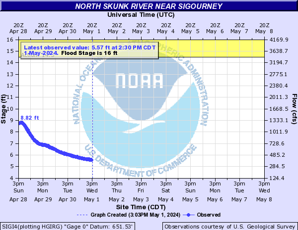
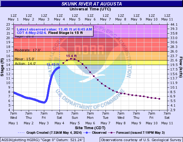
| Skunk River - Create your own custom page for the Skunk River | |||
|
|||
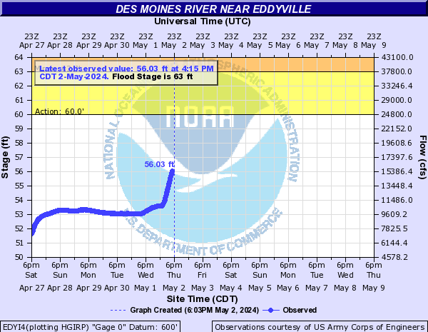
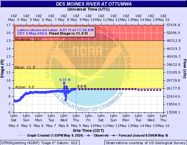
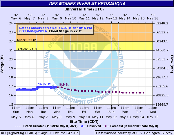
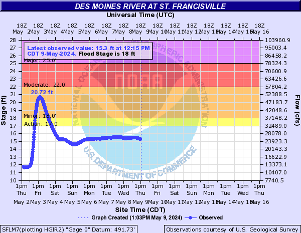
| Des Moines River - Create your own custom page for the Des Moines River | |||||||
|
|||||||
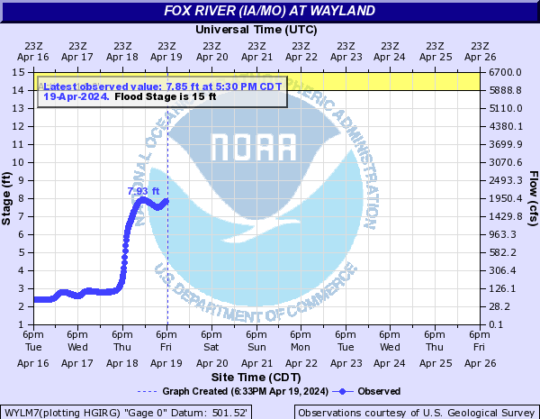
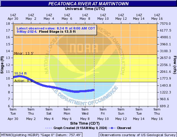
| Pecatonica River - Create your own custom page for the Pecatonica River | |||
|
|||
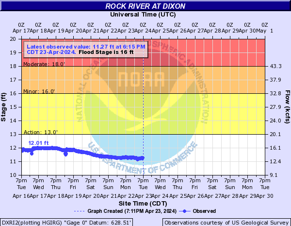
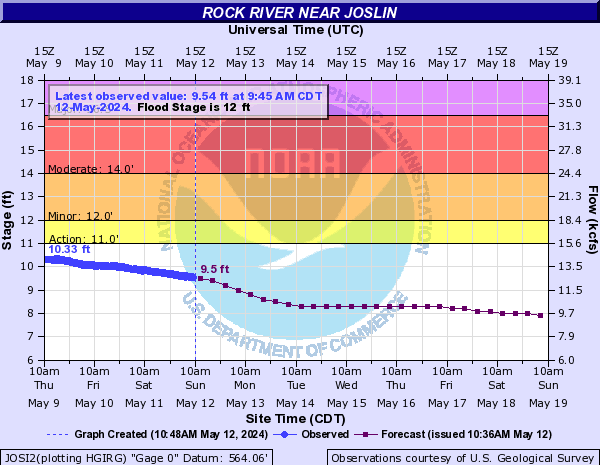
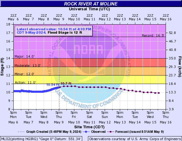
| Rock River - Create your own custom page for the Rock River | |||||||
|
|||||||
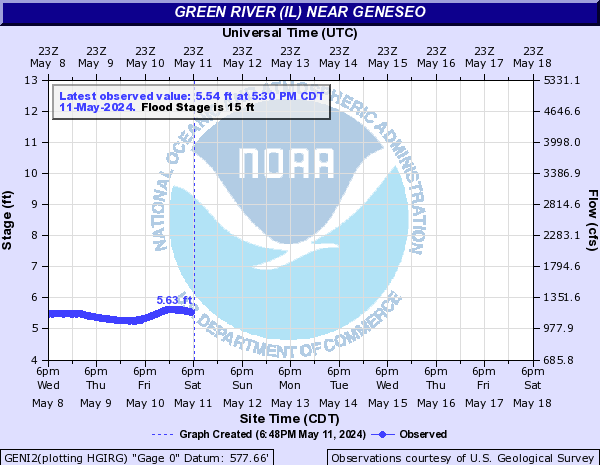
| Green River - Create your own custom page for the Green River | |||
|
|||
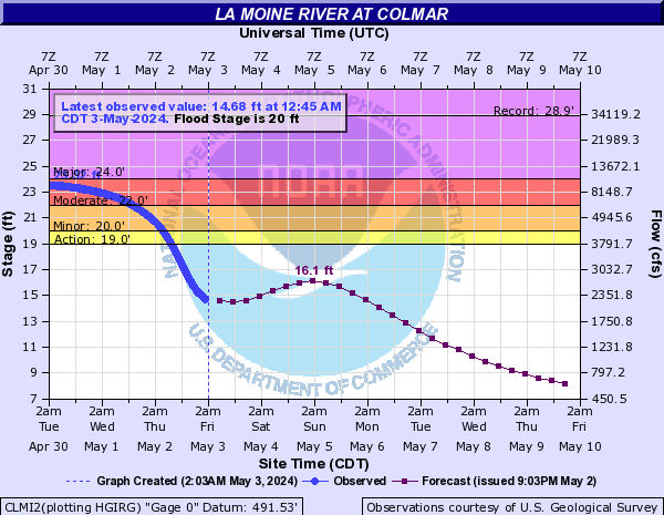
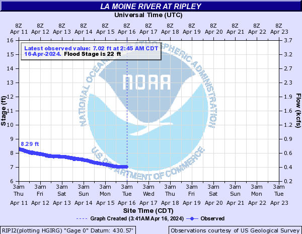
| La Moine River - Create your own custom page for the La Moine River | |||
|
|||
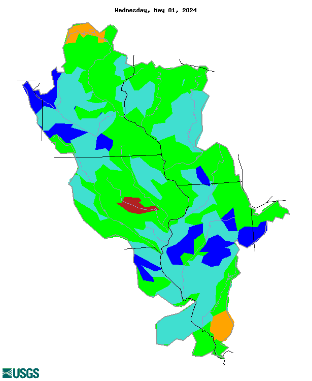
| Drought | ||||||
|
||||||
| Additional Resources | ||||||
|
||||||
Winter Weather
|
|||||||||||||||||||||||||||||||||||||||||||||||||||||||||||||||||||||||||||||||||||||||||||||||||||||||||||||||||||||||||||||||||||||||||||||||||||||||||||||||||||||||||||||||||||||||||||||||||||||||||||||||||||||||||||||||||||||||||||||||||||||||||||||||||||||||||||||||||
| Current Watches, Advisories, and Warnings | ||||||||||||||||||||||||||||||||||||||||||
|
|
|
|||||||||||||||||||||||||||||||||||||||||
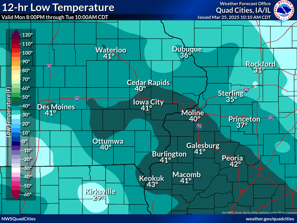
| Frost / Freeze | ||||||||||||||||||
| For comprehensive frost/freeze data, please visit our Frost/Freeze Decision Support Page. | ||||||||||||||||||
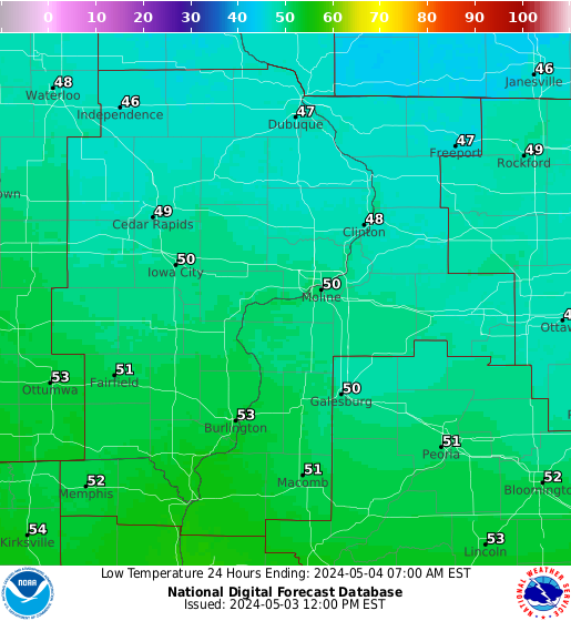
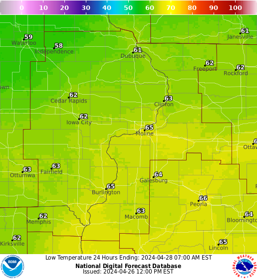
| 12-hr Low Temperature ending at 6 am LST | Low Temperature Forecasts | |||||||||||||||||
| (may not be the actual calendar day low) | Day 1 | Day 2 | ||||||||||||||||
|
|
 |
 |
||||||||||||||||
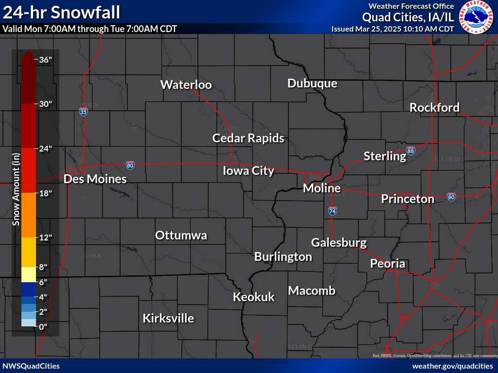
| Snow Conditions from Daily Temperature/Precipitation Maps | ||||||||||||||||||
| Daily Snowfall Map | Daily Snow Depth Map | |||||||||||||||||
 |
 |
|||||||||||||||||
| Local Forecast Parameters from Interactive Graphical Forecast Page | ||||||||||||||||||
SNOWFALL FORECASTS |
||||||||||||||||||
|
||||||||||||||||||
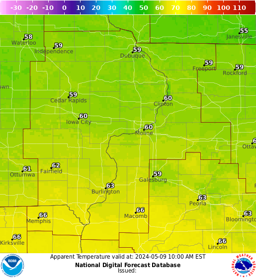
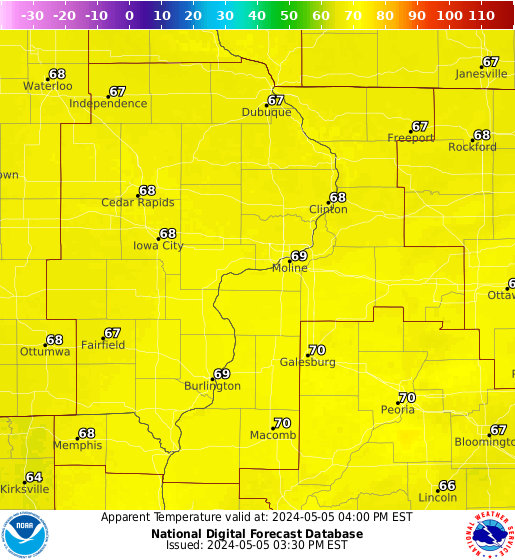
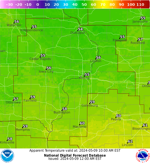
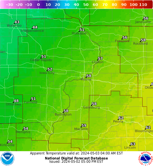
WIND CHILL (Apparent Temperature) FORECASTS |
||||||||||||||||||
| IMPORTANT NOTE: Wind Chill images below are "snapshots" at a specific time. Visit the Interactive Graphical Forecast Page for forecasts at other times. |
||||||||||||||||||
|
||||||||||||||||||
| National Outlooks | ||||||||||||||||||
Day 1 [TEXT] |
||||||||||||||||||
|
||||||||||||||||||
Day 2 [TEXT] |
||||||||||||||||||
|
||||||||||||||||||
Day 3 [TEXT] |
||||||||||||||||||
|
||||||||||||||||||
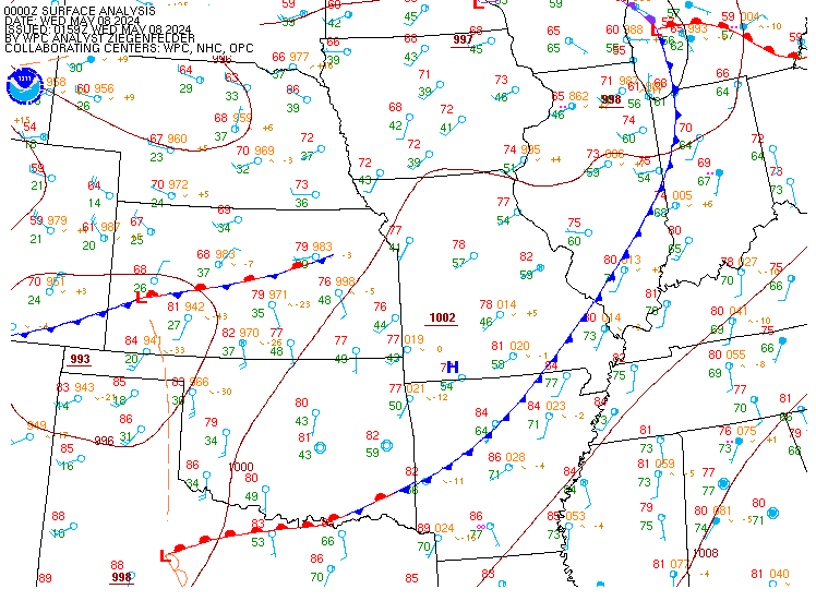
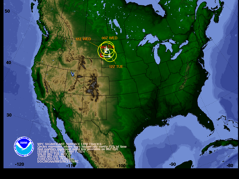
| Weather Maps from WPC | ||||||||||||||||||
|
||||||||||||||||||
| Road Conditions | ||||||
|
||||||
| Additional Resources
Preparedness and Safety |
||||||
Fire Weather
|
||||||||||||||||||||||||||||||||||||||||||||||||||||||||||||||||||||||||||||||||||||||||||||||||||||||||||||||||||||||||||||||||||||||||||||||||||||||||||||||||||||||||||||||||
| Current Watches, Advisories, and Warnings | |||||||||||||||||||||||||||||||||||||||||||||||||||||||||||||||||||||||||||||||||||||||||||||||||
|
|
|||||||||||||||||||||||||||||||||||||||||||||||||||||||||||||||||||||||||||||||||||||||||||||||||
| Local Red Flag Warning | |||||||||||||||||||||||||||||||||||||||||||||||||||||||||||||||||||||||||||||||||||||||||||||||||
|
|||||||||||||||||||||||||||||||||||||||||||||||||||||||||||||||||||||||||||||||||||||||||||||||||
| National Outlooks | |||||||||||||||||||||||||||||||||||||||||||||||||||||||||||||||||||||||||||||||||||||||||||||||||
|
|||||||||||||||||||||||||||||||||||||||||||||||||||||||||||||||||||||||||||||||||||||||||||||||||
| County-by-County Fire Weather Forecast for the Next 7 Days | |||||||||||||||||||||||||||||||||||||||||||||||||||||||||||||||||||||||||||||||||||||||||||||||||
| Area Weather Parameter Forecasts | |||||||||||||||||||||||||||||||||||||||||||||||||||||||||||||||||||||||||||||||||||||||||||||||||
|
|||||||||||||||||||||||||||||||||||||||||||||||||||||||||||||||||||||||||||||||||||||||||||||||||
| Additional Resources | |||||||||||||||||||||||||||||||||||||||||||||||||||||||||||||||||||||||||||||||||||||||||||||||||
|
|
|||||||||||||||||||||||||||||||||||||||||||||||||||||||||||||||||||||||||||||||||||||||||||||||||