Winter Weather Preparedness Week for Georgia is December 1 - 5, 2025. The main threats from winter weather across the Southeast stem from snow and ice storms, but we can also see extreme cold. Last winter season (2024-2025), we finally saw a couple of notable winter storms in January (January 9th and January 21st) despite the overall Winter season (December through February) being slightly warmer than normal. Even in warmer-than-normal winters, bouts of extreme cold, ice and/or snow can still bring dangerous life-threatening winter conditions to the state, so it's important to remain prepared. Take a look below at some of the more recent significant winter weather events that have occurred in our area. Also, read below for the current outlook for the winter ahead.
Recent Winter Weather Events:
*For more winter weather information and resources visit the National Weather Service's Winter Safety Page.
Frostbite and hypothermia are two health hazards associated with cold weather. Frostbite is damage to body tissue caused by extreme cold. A wind chill of -20°F will cause frostbite in just 30 minutes. Frostbite causes a loss of feeling and a white or pale appearance in extremities, such as fingers, toes, ear lobes or the tip of the nose. If symptoms are detected, get medical help immediately! If you must wait for help, slowly rewarm the affected areas. However, if the person is also showing signs of hypothermia, warm the body core before the extremities.
Hypothermia is a condition that can kill and is brought on when the body temperature drops to less than 95°F. Warning signs include uncontrollable shivering, memory loss, disorientation, incoherence, slurred speech, drowsiness and apparent exhaustion. Take the person's temperature and if below 95°F, seek medical care immediately.
It is important to have a safety kit both at home and in the car that can be used not only in winter weather situations but also for other emergencies. Ready Georgia provides a list of items to include in your emergency kit. The following safety tips are provided by the National Oceanic and Atmospheric Administration (NOAA), the Federal Emergency Management Agency (FEMA) and the American Red Cross.
If caught outside in a winter storm:
![[ Wind Chill Chart. ]](/images/ffc/Winter_For_Your_Car.jpg) |
.png) |
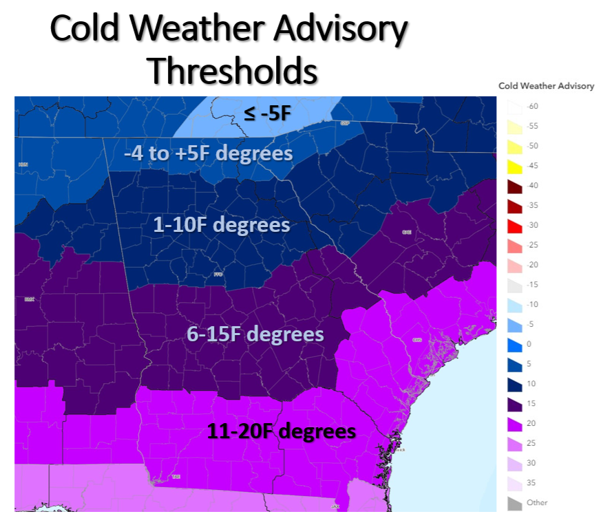
Going into this winter (started last Winter), Wind Chill Warning and Advisory products will no longer be issued by NWS. They've been replaced with "Extreme Cold Watch & Warning" and "Cold Weather Advisory". These new products include both actual air temperature as well as wind chill values. The criteria for issuance for these products will vary based on location within Georgia, with the coldest thresholds in north Georgia and warmer thresholds in central Georgia accounting for climatology. You can find the maps of criteria below:
 |
 |


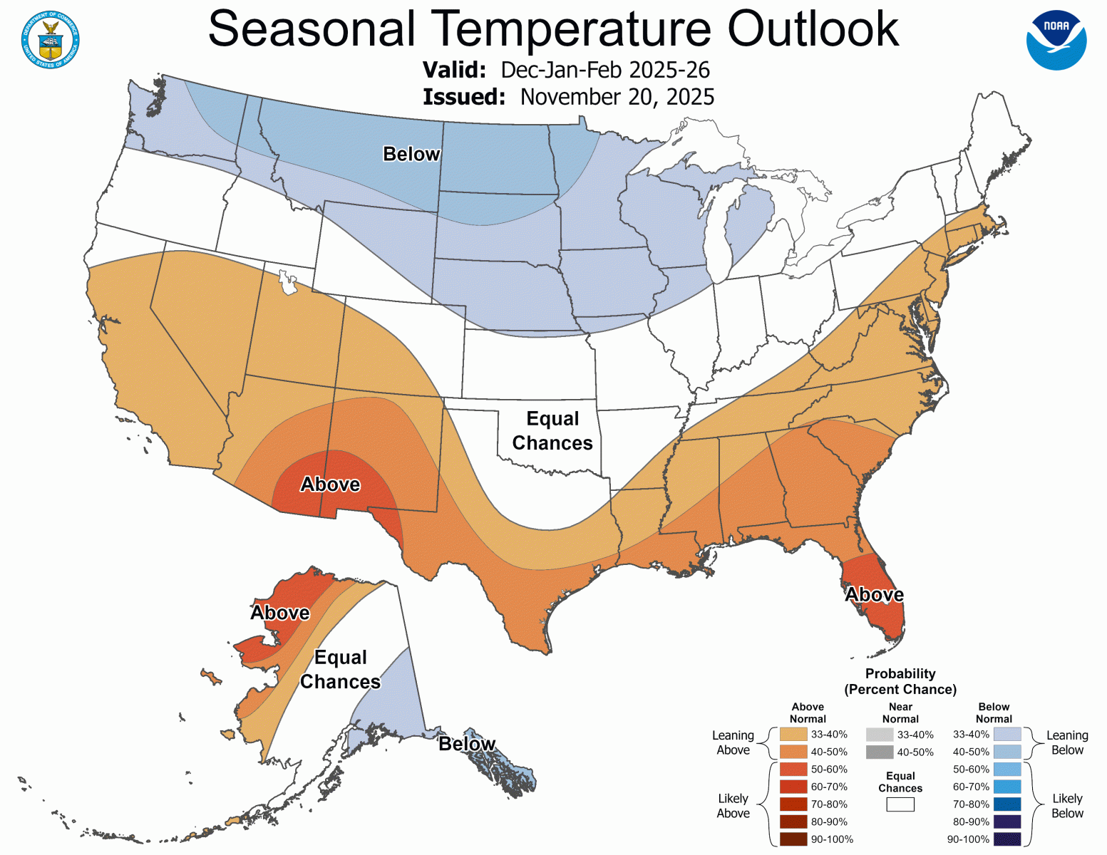
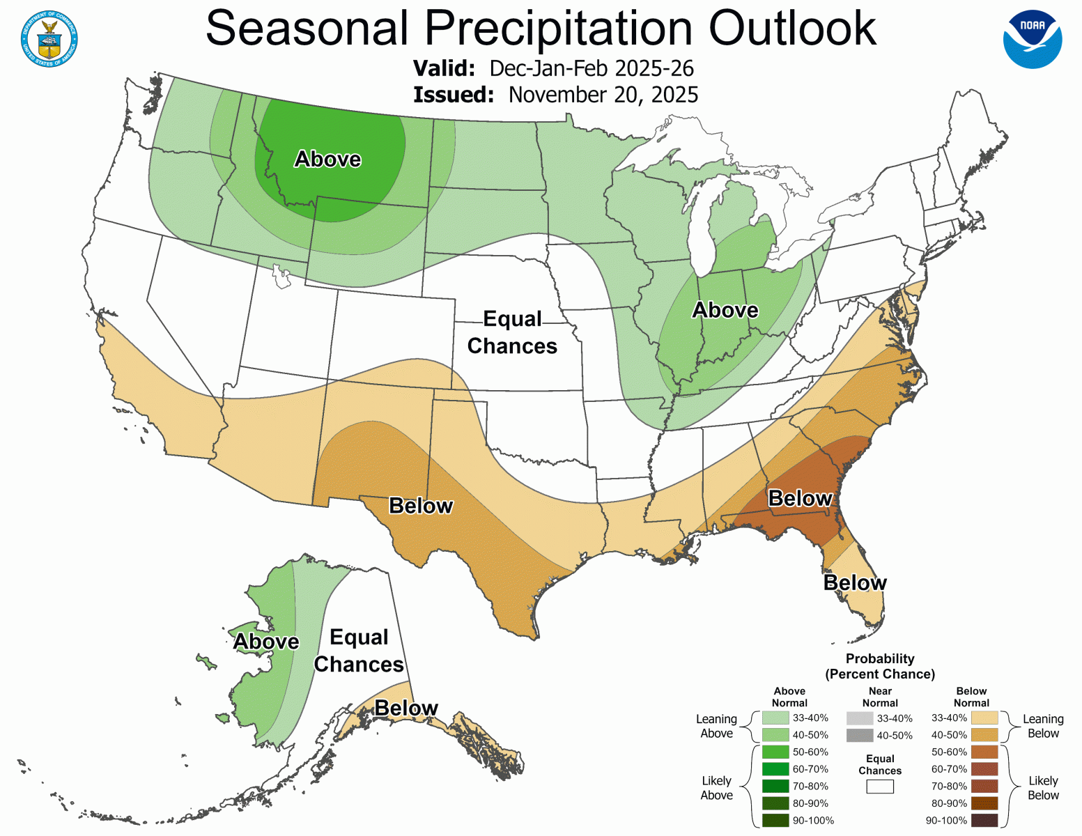
The current outlook from the Climate Prediction Center (CPC) is as follows:
What does this mean?
Similar to last Winter, a weak La Niña will exist this winter, which would favor overall drier and warmer conditions across the Southeast. It is important to remember that periods of cold (below normal) weather will occur, even during an overall warmer season. In fact, some of our significant winter weather events listed above occurred during overall warmer seasons. Thus, it is important to remain prepared for winter weather!
For more technical information on how to interpret climate outlooks and detailed descriptions of the tools used to create these outlooks visit this link.
Looking for winter weather safety tips and more details about our local winter weather program?