On Tuesday night, April 27th, a cold front ahead of low pressure dropped south across the area, kicking off showers which dumped rainfalls of one-third inch to nearly four inches. Most locations received over an inch of rain. It would be the beginning of a very soggy and windy 4-day period which concluded the month of April.
The system, which developed below low pressure aloft, drifted off the southeastern United States coast through Wednesday the 28th, then stalled offshore. This produced widespread light rains across the area which lasted much of the day and into Thursday the 29th. By the morning of Friday the 30th, the upper low had moved offshore and become separated from the jet stream winds above it which steered the system. It was cutoff and adrift just off the coast. Feeding off the warm Gulf Stream waters, it intensified off our coastline. Meanwhile, high pressure was building down the leeward side of the Appalachians. Strong northeast winds between the two systems pounded the coastal sections, producing wind gusts to 60 miles an hour along the beaches. A coastal flood watch was issued Friday afternoon. Offshore, winds approached hurricane force.
The flow off the Atlantic also ushered in copious amounts of moisture. During the course of Friday and Saturday (May 1st), rainfall reports of 7 to 10 inches were prevalent across portions of coastal southeastern North Carolina. The National Weather Service office at the Wilmington International Airport reported rainfall at the top of the hour for 43 straight hours and 55 out of 60. Three of those hours had rain during the hour, but not at observation time, so 58 out of 60 hours actually contained rain. Flood warnings were posted for the area around the Port City. Totals dropped to 1 to 2 inches far from the coast.
By Sunday morning, the 2nd, a ridge of high pressure aloft moving toward the East Coast kicked the upper low into gear and shoved it out to sea, taking the surface low with it. While winds between the high and low continued to blow at 40 miles an hour along the beaches through the day, the rain came to an end during the early morning. High rainfall totals were around 13 inches in 4 days in the Masonboro Loop area, just outside of Wilmington. Numerous other reports of greater than 10 inches of rain were received from the region. The combination of the heavy rains and tidal flooding caused the lake at Carolina Beach to overflow, flooding the north end of the town for nearly 2 days. Minor beach erosion was reported along New Hanover county's beaches. Areas that had been in a rainfall shortage since the beginning of the year were suddenly back on the wet side.
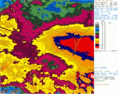
The image below is the Doppler radar estimate of rainfall from 12:55 PM 4/27 through 10:26 AM 5/2. The heaviest rain was indicated across much of New Hanover into Brunswick county with rainfall totals in excess of twelve inches.
Below is a listing of the rainfall amounts.
PUBLIC INFORMATION STATEMENT...FINAL REVISED
NATIONAL WEATHER SERVICE WILMINGTON NC
400 PM EDT MON MAY 3 1999
HERE ARE SOME COASTAL STORM-RELATED RAINFALL AMOUNTS (IN INCHES)
FROM AROUND THE AREA. THEY ARE TOTALS FROM 8AM THURSDAY MORNING TO
8AM SUNDAY MORNING:
LOCATION                          COUNTY              TOTAL
MASONBORO LOOP AREA (SE OF ILM)   NEW HANOVER         13.17
MASONBORO LOOP AREA               NEW HANOVER         12.98
LORIS                             HORRY               12.82
CAROLINA BEACH                    NEW HANOVER         12.30
WRIGHTSVILLE BEACH                NEW HANOVER (INC.)  11.30
LAKE WACCAMAW                     COLUMBUS            10.98
KINGSTREE                         WILLIAMSBURG        10.90
WILMINGTON                        NEW HANOVER (INC.)  10.71
SUNNY POINT MIL. OCEAN TERM.      BRUNSWICK           10.71
LELAND                            BRUNSWICK           10.23
CASTLE HAYNE                      NEW HANOVER          9.29
WILMINGTON INTL AIRPORT           NEW HANOVER          9.03
5 MILES S OF WHITEVILLE           COLUMBUS (INC.)      8.84
LONGWOOD                          BRUNSWICK            8.22
CAPE FEAR LOCK & DAM 1            BLADEN               7.60
1 MILE W OF WRIGHTSVILLE BEACH    NEW HANOVER          7.54
OUTLAND                           GEORGETOWN           7.33
FAIR BLUFF                        COLUMBUS             6.86
7 MILES NW OF WHITEVILLE          COLUMBUS             6.69
EFFINGHAM                         FLORENCE             5.87
WHITEVILLE                        COLUMBUS (INC.)      5.78
5 MILES W OF SHALLOTTE            BRUNSWICK            5.60
MULLINS                           MARION               5.51
CADES                             WILLIAMSBURG         5.49
WATHA                             PENDER               5.25
LUMBERTON                         ROBESON              5.16
MOORES CREEK NATL BATTEFIELD      PENDER (INC.)        4.94
LUMBERTON AIRPORT                 ROBESON              4.84
FLORENCE REGIONAL AIRPORT         FLORENCE             4.78
CONWAY                            HORRY (INC.)         4.77
DARLINGTON                        DARLINGTON           4.77
2 MILES N OF HARTSVILLE           DARLINGTON           4.72
HARTSVILLE                        DARLINGTON           4.65
DILLON                            DILLON               4.30
8 MILES NE OF HARTSVILLE          DARLINGTON           4.13
NORTH MYRTLE BEACH                HORRY                3.74
WILLIAM O. HUSKE LOCK & DAM       BLADEN               3.26
(INC.) MEANS INCOMPLETE DATA
OTHER NOTE OF INTEREST: WILMINGTON INTERNATIONAL AIRPORT HAD 43
STRAIGHT HOURS OF RAINFALL AND 55 HOURS OUT OF 60 OVERALL FROM
THURSDAY AFTERNOON TO LATE SATURDAY NIGHT.


 Coastal Flood