![]()
| Event Description
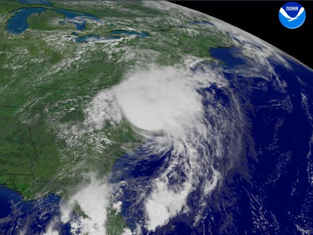
Charley was identified as a tropical depression on August 9, just east of Grenada in the Windward Islands. On the 10th, it reached tropical storm strength in the southern Caribbean, and on the 11th hurricane strength just south of Jamica. On the night of August12-13th, Charley crossed western Cuba as a Category 2 hurricane with winds near 105 mph, and in the early morning a tropical storm watch was raised for the Carolina Coast from South Santee River to Cape Fear. Winds increased to 110 mph as the storm moved north, passsing west of Key West on the morning of the 13th, as the tropical storm watch was extended to Oregon Inlet, NC. Charley strengthened to Category 4 with winds near 145 mph before making landfall in the late afternoon on the west coast of Florida between Fort Myers and Tampa, in Charoltte County, as a tropical storm warning was upgraded to a hurricane warning along the Carolina Coast to Cape Lookout. Charley crossed the Florida peninsula during the night, weakening to Category 1 strength with winds around 85 mph before moving off the east coast near Daytona on the early morning on August 14. Accelerating forward speed to around 30 mph as it moved northeast just off the coast, the center of Charley made landfall at about 9 am just south of Georgetown, SC at Cape Romain as a weak Category 1 hurricane, with 2 minute sustained wind estimated near 75 mph. Moving inland, Charley was downgraded to tropical storm strength. Charley moved off the coast near Virginia Beach on the evening of the 14th and crossed Long Island, NY and southern New England on the morning of the 15th. |
|
Actual Track of Charley (click to enlarge)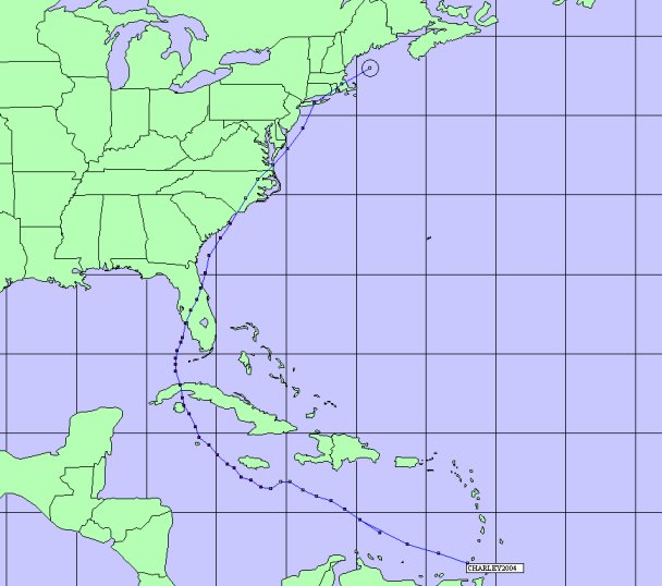
|
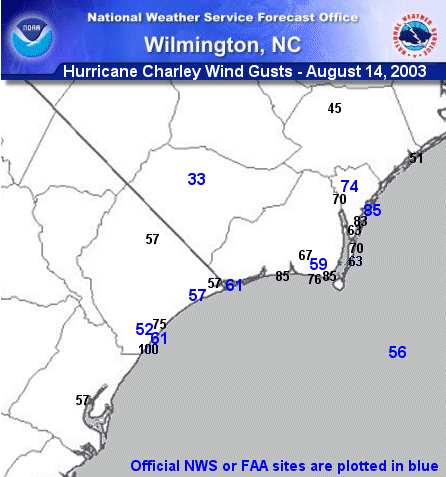
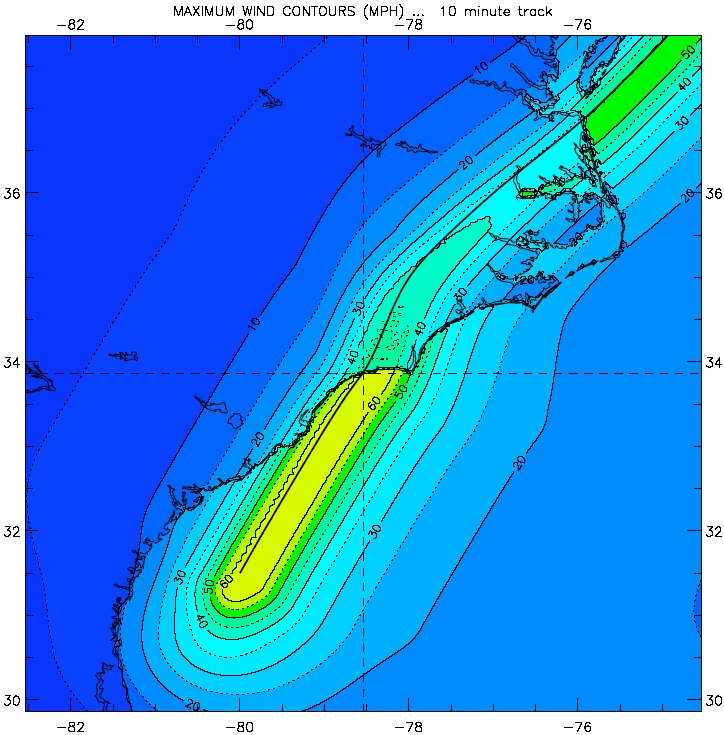
| Plot of Highest Winds
|
Highest Winds (Note: Official NWS or FAA sites are shaded in gray)
|
||||||||||||||||||||||||||||||||||||||||||||||||||||||||||||||||||||||||||||||||||||||||||||||||||||||||||||||||||||||||||||||||||||||||
|
Rainfall North Carolina
South Carolina
Flooding: Heavy rains occurred as a rain band just ahead of the storm center caused ponding, especially in Georgetown and Horry Counties. Rainwater flooding occurred in other low lying areas but generally drained in a couple of hours. |
|
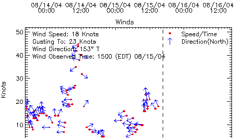
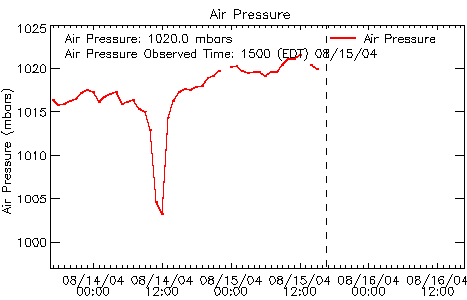
Lowest Pressure:
Wilmington Intl. Airport: 1005 mb at 1250 EDT
Johnnie Mercer Pier (Wrightsville Beach): 1007.3 mb at 1336 EDT and 1342 EDT
Sunset Beach Pier: 998 mb at 1200 EDT
North Myrtle Beach Airport: 998 mb at 1209 EDT
Springmaid Pier, Myrtle Beach: 998.2 mb at 1142 EDT
Florence Airport: 1014 mb at 1152 EDT
Frying Pan Shoals Buoy (35 nm SE of Bald Head Island): 1014.4 mb at 1150 and 1250 EDT
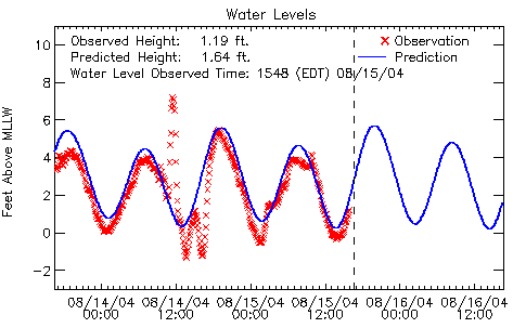
Storm Tides:
Because the surge occurred near astronomical low tide, the surge made the storm tide comparable to a very high astronomical high tide.
Long Bay...
Myrtle Beach Springmaid Pier: 7.19' at 1130 EDT...About 6' surge.
Brunswick County Beaches: Estimated 7-8' surge. Minor overwash at St. James Plantation. 2-3' Coastal Flooding at Bald Head Island, where overwash occurred along a sandbagged stretch of beach, over roads damaged by Alex, and under some homes on pilings.
Onslow Bay...
New Hanover County: 3-4' surge. No coastal flooding reported.
Pender County: 2-3' surge. No coastal flooding reported.
Beach Erosion: Bald Head Island (Cape Fear in Brunswick County) lost more along a sandbagged area, where more asphalt was lost. No erosion reported elsewhere.
Tornadoes: None.
Storm Effects: Evacuations were mandatory in Georgetown and Horry Counties east of U.S. 17, and about 180,000 people left the Grand Strand. In North Carolina, evacuations were mandatory on Brunswick County beaches and voluntary elsewhere. Up to 1,000 were sheltered, and most shelters were closed by the end of the day.
Deaths or Injuries: Only a few minor injuries were reported. No deaths.
Damage: Most damage was along and east of the path of the storm center, mainly in New Hanover and Brunswick Counties where insurance claims are expected to exceed $10 million. Power outages there were widespread due to snapped and uprooted trees and limbs on power line. Many signs and some gas pump roofs were downed.
Brunswick County: About $6.3 million in damage. Considerable roof and siding damage and some structural damage from wind, trees, and debris. Total estimate 2,231 structures damaged, 231 with major damage (at least 20% building value) and about 40 destroyed. Damage at Sunset Beach to 221 homes, 106 homes at Oak Island, 202 homes and 96 condos at Caswell Beach, and 16 homes destroyed at Calabash. Crops: 50% of the tobacco, 30% of corn and 30% of field vegetables.
New Hanover County: About $3 million in damage to buildings, businesses and in government expenses. Unincorporated areas of county: $1.3 million at Wrightsville Beach, $282 thousand at Kure Beach. Vegetative debris widespread, plugged storm drains and contributed to ponding and flooding the next day.
Pender County: $875 thousand in damage, following $1.27 million in damage from an F2 tornado in the remnants of Tropical Storm Bonnie in Rocky Point on the morning of August 13th, which killed 3 people.
Columbus County: 5 Houses had trees on the roofs.
Bladen County: Trees fell on a few houses.
Horry and Georgetown Counties: About $5 million in insurance claims, mostly along the Grand Strand of Horry County. Downed trees, roof damage and flooding along the coast due to wind and rain. Rainwater flooding inland. 65,000 lost power. Surfside Beach damage $50 thousand. Georgetown County Government damage and cleanup costs $1.5 million.
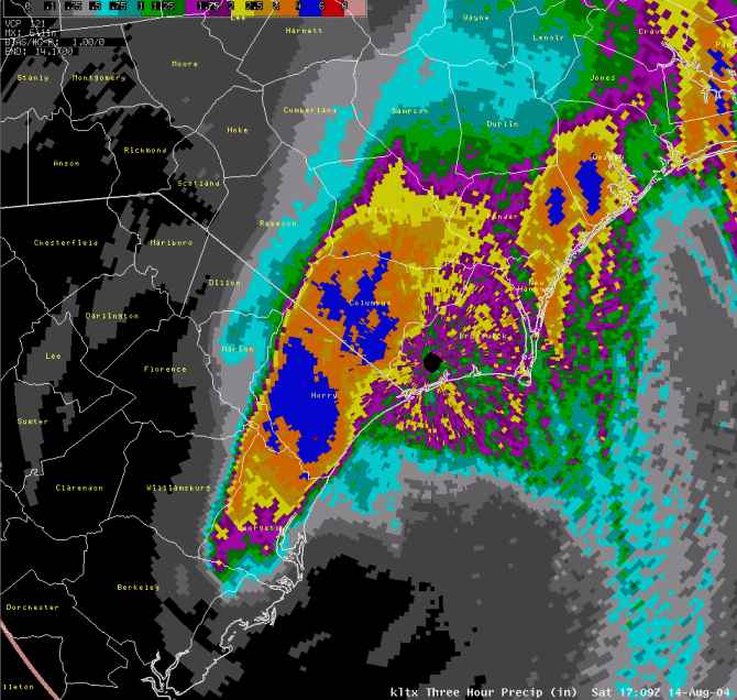
Radar (base reflectivity) Data from Wilmington, NC (click to enlarge):
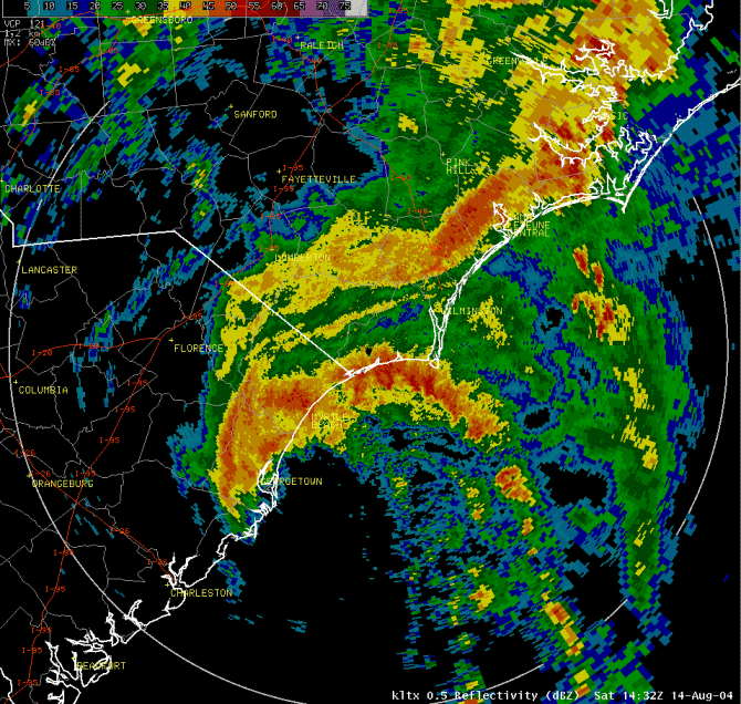 1030 EDT Radar Image |
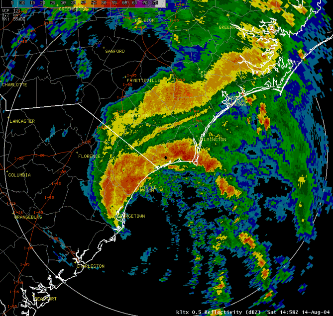 1100 EDT Radar Image |
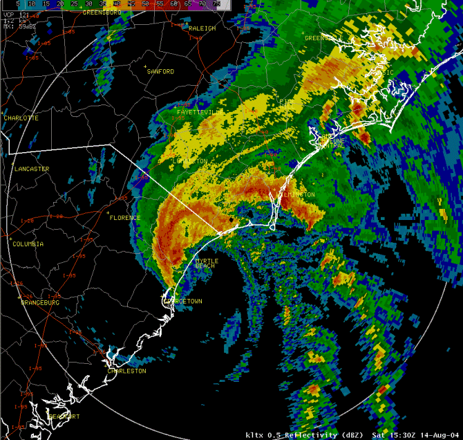 1130 EDT Radar Image |
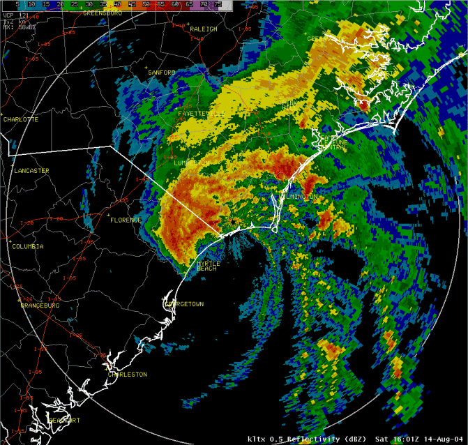 1200 EDT Radar Image |
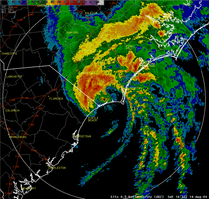 1230 EDT Radar Image |
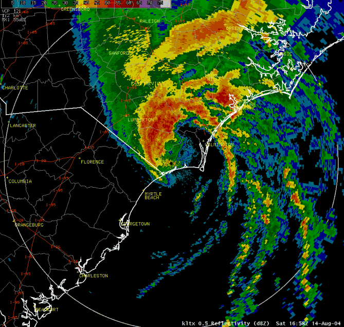 1300 EDT Radar Image |
Data from Springmaid Pier (Myrtle Beach, SC):
 |
 |
 |
.gif) |


 Coastal Flood