March, April, and May of 2021 collectively were one of the driest springs across eastern North and South Carolina since local records began in 1871. After ample rainfall fell during the winter, rains abruptly stopped in early March. Consistently dry weather continued through the spring and led to intensifying drought conditions during April and May.
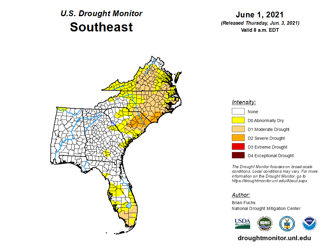
By June 1, the U.S. Drought Monitor showed significant portions of eastern North and South Carolina in a "moderate" to "severe" drought classification -- D1 and D2 on a scale that goes up to D4. This was the first time since November 2019 that any portion of North Carolina had an officially declared drought.
|
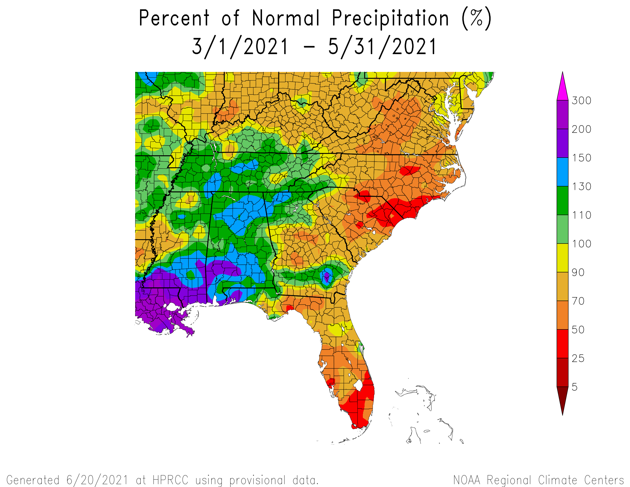
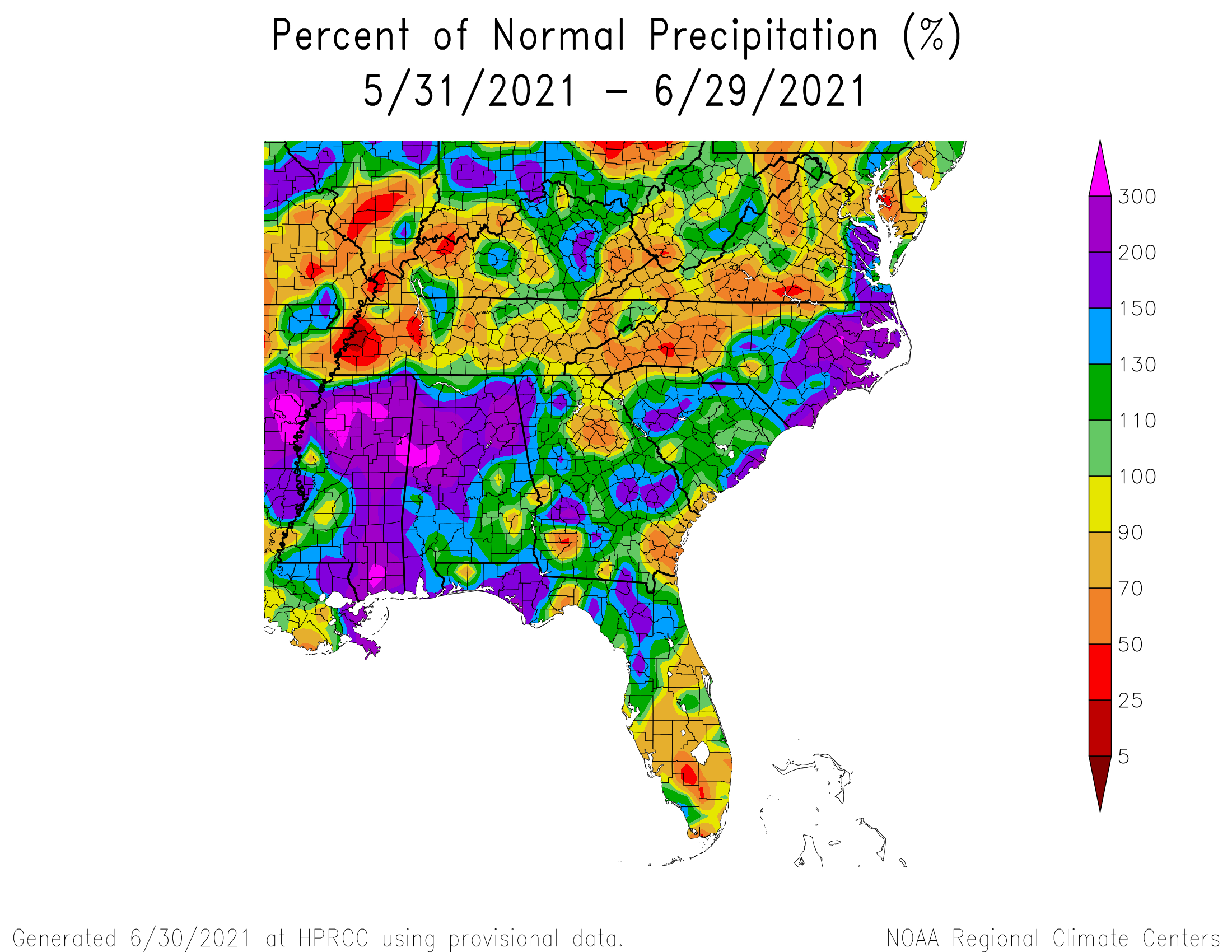
Spring rainfall was well below normal across eastern North and South Carolina. Red shading on this map represents rainfall less than 50 percent of normal. |
The U.S. Drought Monitor on June 1 showed moderate to severe drought across portions of eastern North and South Carolina, closely matching observed rainfall deficits. |
The Spring edition of the Climate Impacts Report from the Southeast Regional Climate Center noted the drought negatively impacted farmers and slowed spring planting of cotton, tobacco, and other row crops. As pastureland dried out, livestock farmers were forced to rely on stored hay to feed their animals.
Other sources mentioned slowed and stunted corn growth during the spring, as well as delays planting soybeans and peanuts.
The North Carolina Forest Service issued a burn ban for 26 counties in late May due to the dry conditions. In southeastern North Carolina this ban included Bladen, Brunswick, New Hanover, Pender, and Robeson counties. The Forest Service reported on May 27 there had been 536 fires across North Carolina scorching 3100 acres. The month of May normally sees 226 fires burn just 797 acres in North Carolina.
Measured Rainfall Amounts and Departures from Normal
|
Wilmington, NC
Second driest spring on record since 1871 in Wilmington. |
Lumberton, NC
Second driest spring on record since 1903 in Lumberton. |
North Myrtle Beach, SC
Third driest spring on record since 1932 in N. Myrtle Beach. |
Florence, SC
Second driest spring on record since 1948 in Florence. April rainfall was the lowest on record. |
The Cape Fear Public Utility Authority (CFPUA) issued voluntary water conservation alerts for New Hanover County customers in May. Brunswick County also asked residents to reduce water use through a Stage 1 Water Conservation Alert which affected most water utilities in the county. Pender County officials sent a warning message to its residents about the increasing need to conserve water.
|
WLTX TV in Columbia, SC reports on the drought's impact on farmers in South Carolina |
Meteorological Reasons for the Drought
Well below normal rainfall occurred from March through May -- essentially lasting the entirety of climatological spring. The most likely reason for the drought appears to have been persistent high pressure across the Ohio Valley and low pressure over New Brunswick and Nova Scotia, Canada. The resulting anomalous northerly winds between these two systems kept cool and dry Canadian air flowing across the Carolinas throughout the spring months. Relative humidity was up to ten percent below normal since so little moisture could reach the Carolinas from the Atlantic Ocean or the Gulf of America.
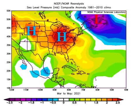 |
This reanalysis map shows the observed barometric pressure difference from normal from March through May of 2021. Air pressure averaged up to 2.5 millibars above normal across the Ohio Valley (marked with a blue "H") and 2.5 millibars below normal (marked with a red "L") across the Canadian maritime provinces.
|
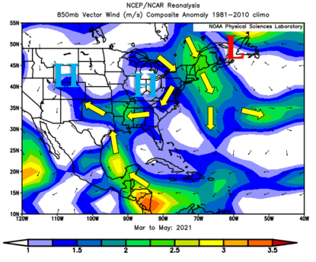 |
This reanalysis map shows the observed 850 millibar wind vector difference from normal from March through May of 2021. Because of persistent high pressure across the Ohio Valley and persistent low pressure across the Canadian maritime provinces, winds from New England into the Carolinas blew from the north more often than normal this spring. 850 millibars is a pressure level found approximately 5000 feet above sea level. It's a standard level used in meteorology for tracking the flow of moisture that influences the location and intensity of rainfall. |
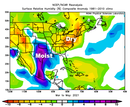 |
This reanalysis map shows the observed relative humidity difference from normal at the surface from March through May of 2021. Persistent north winds during the spring meant moisture from the Atlantic Ocean and the Gulf of America was not able to reach the Carolinas. This caused the air to become drier than normal, leading to fewer clouds and fewer opportunities for rainfall. |
End of the Drought
As quickly as the drought developed, the start of summer led to a rapid return to wet conditions. The Bermuda high became strong and persistent during June, leading to the development of southerly winds which brought Atlantic moisture across the Carolinas. Increasing coverage of showers and thunderstorms began to alleviate the drought during June, and by mid-July all drought classifications were dropped. Local climate stations all reported above annual rainfall amounts by July.
|
Above-normal rainfall developed in June across coastal North and South Carolina. June's rainfall amounts were slightly above normal across South Carolina's Pee Dee region. In Wilmington where drought raged during the spring, 12.26 inches of rain fell in June, the fourth highest June rainfall total since 1871. |
The U.S. Drought monitor showed drought conditions had ended by the middle of July across eastern North and South Carolina. |
Additional Reading
NWS Wilmington: Spring 2021 Climate Summary
WECT: Brunswick County, CFPUA Issue Voluntary Water Conservation Alerts
WECT: Pender County Issues Warning about Water Use as area Experiences Moderate Drought
NC Policy Watch: Uh-oh, nearly two-thirds of N.C. is Abnormally Dry or in a Drought
Southeast Regional Climate Center: Spring 2021 Climate Impacts Report
Page Author: Tim Armstrong
Last Updated: July 25, 2021


 Coastal Flood