|
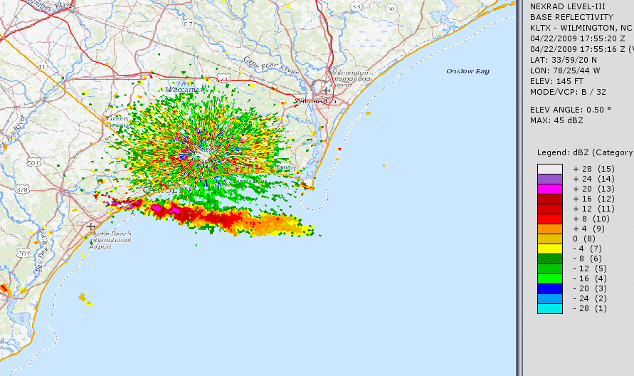
Radar loop of the smoke plume from the Highway 31 fire from 1:45 PM on April 22, 2009 through 2:58 PM on April 23, 2009. At one point radar was able to track the dense smoke 100 miles away from the fire. |
On April 22, 2009 a small debris burn on private land east of Conway, South Carolina grew into a massive wildfire that eventually destroyed 76 homes across eastern Horry County. Official estimates included $25 million in property damage and $17 million in agricultural damage. Over 19,000 acres was consumed by this fire, and the evacuation of 4,000 Horry County residents was ordered by emergency management officials. The fire burned across the unique "Carolina Bay" landscape where peat soils support dense, waxy vegetation and scattered tall pines -- an environment that has historically produced at least three other large wildfires in the same area since 1950. This was believed to have been the largest South Carolina wildfire since the Clear Pond Fire burned 30,000 acres of the same general area in 1976.
Weather conditions on April 22 contributed significantly to the rapid growth of the fire. Low relative humidity and strong west winds helped quickly fan the flames into an inferno that moved east from the ignition point. Wildfires at night tend to slow their spread as weaker wind speeds and higher relative humidity develop -- however the Highway 31 fire was so intense that a persistent, deep column of rising air over the fire continued to mix down strong winds and dry air from several thousand feet aloft through the night. This led to adverse fire behavior and rapid spread of the fire through the night and into April 23.
|
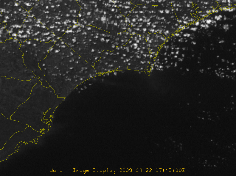
Visible satellite loop of the Highway 31 fire from April 22 and 23, 2009. The smoke plume can be seen blowing east across North Myrtle Beach and the Atlantic Ocean. Onshore seabreeze winds on the afternoon of April 23 began to spread smoke north across the state line into southern Columbus County, NC |
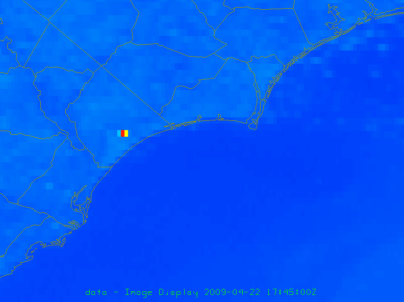
Shortwave Infrared satellite imagery reveals the extreme heat signature associated with the Highway 31 fire. This satellite channel is typically used by meteorologists during the daytime to distinguish ice versus water clouds, but also can be useful gauging the size and intensity of wildfires. |
A good example of just how much the environment differed from inside the smoke plume to outside can be seen with weather observations from two airports along the Grand Strand: North Myrtle Beach and Myrtle Beach. Early in the morning of April 23, 2009, the smoke plume moved across the North Myrtle Beach airport. Winds and temperatures were both higher inside the fire's smoke plume, while visibility and dewpoint were both lower. Firefighters battling the fire had their jobs complicated by the wind and the dry air that the fire helped produce.
|
North Myrtle Beach, SC (inside the smoke plume)
|
Myrtle Beach, SC (south of the smoke plume)
|
According to a report issued by the South Carolina Forestry Commission, the Highway 31 fire was contained on April 28, and was finally declared controlled after burning for almost a month on May 20. Fortunately there were no injuries to firefighters or to the public.
A team of National Weather Service meteorologists from Wilmington, NC studied the meteorological factors in place during the Highway 31 fire, focusing on the adverse factors that contributed to the rapid spread of the fire during its first night. Their research was published in a 2018 paper titled Recognizing the Potential for Dangerous Nocturnal Fire Growth and its Implications for Fire Weather Products and Services. A set of guidelines was developed to help recognize weather scenarios that favor nighttime fire growth.
Links to additional information on the Highway 31 fire of April 2009
Recognizing the Potential for Dangerous Nocturnal Fire Growth and its Implications for Fire Weather Products and Services by Lebo, Neuherz, Pfaff, and Weiss (2018)
South Carolina State Forestry Commission After-Action Report on the Highway 31 Fire
South Carolina State Forestry Commission final public update on the Highway 31 Fire
| U.S. Forest Service video including candid interviews with two of the firefighters who saw the worst portion of the Highway 31 Fire. |
Research and Page Author: Tim Armstrong
Page Created: April 22, 2019
Last Modified: April 22, 2019


 Coastal Flood