|
|
|
|
|
|
|
|
|
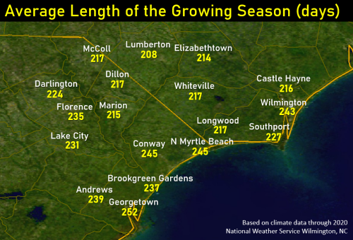
Since 1950 almost all climate stations across the Eastern Carolinas have shown increases in the length of the growing season. Averaged across our area:
North Carolina State University and Clemson University have put together excellent state-specific resources for various garden vegetables including varieties and times needed to mature for harvest: NCSU Planting Guide, and Clemson Planning a Garden Even in the coldest years in eastern North or South Carolina there is plenty of time in the growing season to grow virtually any type of garden vegetable. Drought or extreme heat are normally much larger concerns for farmers and gardeners.
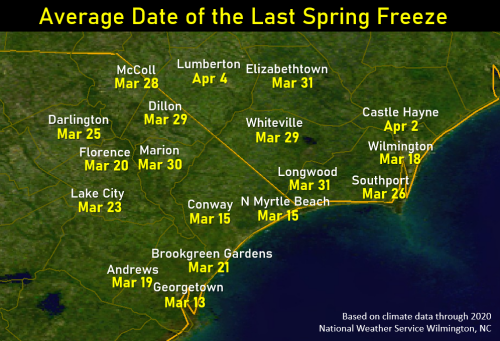
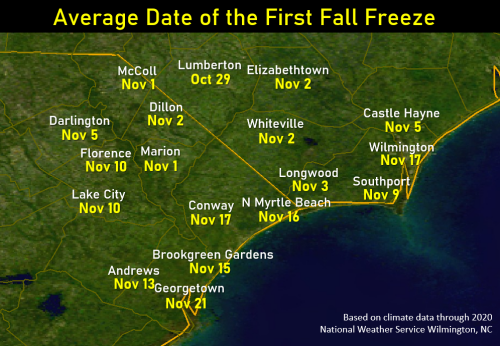
Many factors determine how much nighttime temperatures vary from place to place. It's worth mentioning there are two types of freeze events: an advective freeze and a radiational freeze. An advective freeze occurs when strong winds (usually northwest or north winds) bring cold air into the region. Since winds continue blowing through night any small-scale temperature variations are evened out. On nights when skies are clear and winds are calm, a very different event occurs called a radiational freeze. On these nights microclimates appear where temperatures can vary widely from neighborhood to neighborhood. Differences in tree cover and vegetation, proximity to water, slope and elevation, and even soil type help create these temperature differences.
Soil type and proximity to water have the most impact here in the Eastern Carolinas. Peat soil or soils with high organic content like are found in Carolina Bays and pocosin swamps produce the coldest nights and shortest growing seasons. Proximity to water (ocean, rivers, and lakes) provides locally warmer temperatures and extends the growing season length.
For Wilmington, Lumberton, Florence, and North Myrtle Beach, climate observations used in this study were collected at the local airports using ASOS weather stations. The remainder of the data shown here originates from the NWS Cooperative Observation Program, a network of thousands of volunteer observers who report their highs, lows and daily precipitation to the National Weather Service. Official equipment and training is provided by the National Weather Service to ensure the data collected is high quality. The countless hours of public service volunteered by Cooperative Observers over the years have been invaluable in establishing a more complete picture of the climate of the United States.
Research and Page Author: Tim Armstrong
Last Updated: March 7, 2021


 Coastal Flood