Read the Hazardous Weather Outlook (click to read)
354 FLUS43 KJKL 211054 HWOJKL Hazardous Weather Outlook National Weather Service Jackson KY 654 AM EDT Thu Aug 21 2025 KYZ087-088-118-120-221200- Bell-Harlan-Letcher-Pike- 654 AM EDT Thu Aug 21 2025 This Hazardous Weather Outlook is for a portion of eastern Kentucky. .DAY ONE...Today and tonight. Isolated thunderstorms will be possible this afternoon and evening for areas along the West Virginia and Virginia state lines. .DAYS TWO THROUGH SEVEN...Friday through Wednesday. There is a slight chance of afternoon and evening thunderstorms on Friday, mainly in southeast Kentucky. Thunderstorms are possible area wide Saturday through Sunday. .SPOTTER INFORMATION STATEMENT... Spotter activation is not expected at this time. $$ KYZ044-050>052-058>060-068-069-079-080-083>086-104-106>117-119- 221200- Fleming-Montgomery-Bath-Rowan-Estill-Powell-Menifee-Rockcastle- Jackson-Pulaski-Laurel-Wayne-McCreary-Whitley-Knox-Elliott-Morgan- Johnson-Wolfe-Magoffin-Floyd-Lee-Breathitt-Knott-Owsley-Perry-Clay- Leslie-Martin- 654 AM EDT Thu Aug 21 2025 This Hazardous Weather Outlook is for a portion of eastern Kentucky. .DAY ONE...Today and tonight. No hazardous weather is expected at this time. .DAYS TWO THROUGH SEVEN...Friday through Wednesday. There is a slight chance of afternoon and evening thunderstorms on Friday, mainly in southeast Kentucky. Thunderstorms are possible area wide Saturday through Sunday. .SPOTTER INFORMATION STATEMENT... Spotter activation is not expected at this time. $$ VORST
Read the Area Forecast Discussion (click to read)
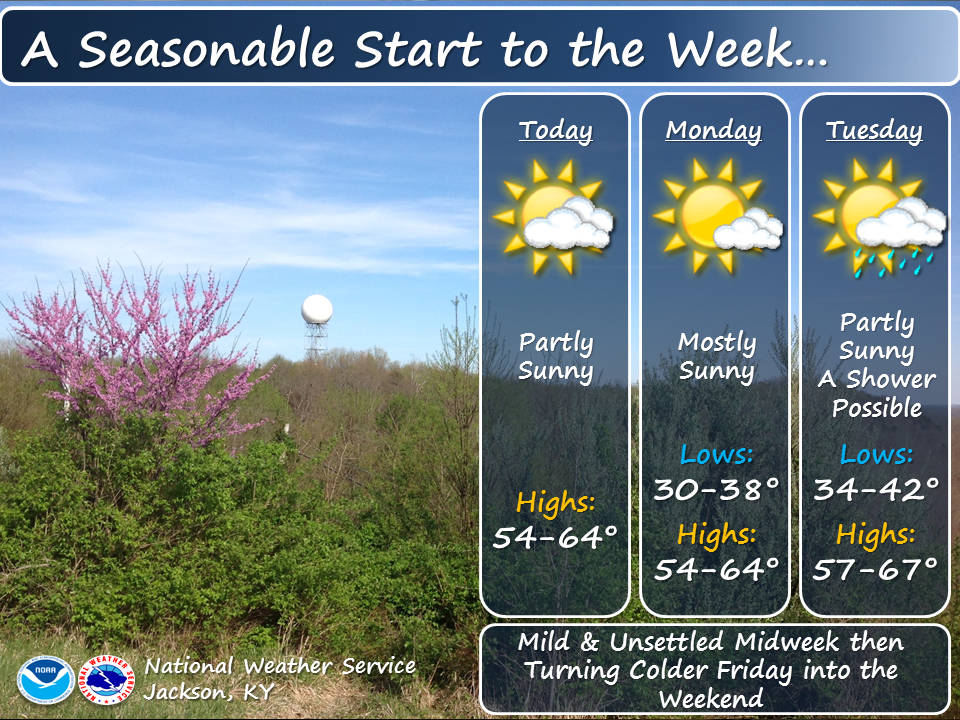
805 FXUS63 KJKL 211835 AFDJKL AREA FORECAST DISCUSSION National Weather Service Jackson KY 235 PM EDT Thu Aug 21 2025 .KEY MESSAGES... - Showers and thunderstorms will be possible at times through Friday, mainly in southeast Kentucky during afternoon and evening hours. - A cold front will bring increased chances for storms Saturday into Sunday. - A noticeable cool-down is expected next week where temperatures will be 10 to 15 degree below normal. && .UPDATE... Issued at 1246 PM EDT THU AUG 21 2025 Clouds have started to break up near the VA border and north of the Mountain Parkway, but the process has been slow to get underway. Have made adjustments to temperatures based on the latest trends due to cloud patterns, and have also backed off more on the POP due to weaker destabilization in some places in southeast KY that had precip mentioned in the forecast. UPDATE Issued at 952 AM EDT THU AUG 21 2025 Although there are some breaks in the clouds showing up, overall, clouds remain socked in. This is slowing the temperatures rise and could end up affecting afternoon highs. Have updated the forecast for a slower decrease in clouds and slightly cooler max temps today. It could also be more difficult to get convective precip, and the POP has been lowered slightly where it was present in southeast KY. && .SHORT TERM...(Today through Friday) Issued at 435 AM EDT THU AUG 21 2025 A cold front from yesterday is now southeast of the area, oriented west to east from the Ozarks to the Mid-Atlantic. A surface high- pressure system is dominating the weather across much of the Central Plains and Midwest, including Kentucky. This is leading to mostly clear skies, with the exception of pockets of overnight stratus clouds. To the east, Hurricane Erin is tracking northwestward toward North Carolinas Outer Banks. Locally in eastern Kentucky, post- frontal high pressure is moving into the area, bringing mostly clear skies, though low-level stratus overhead is keeping overnight temperatures slightly warmer. Temperatures are still falling into the mid to upper 60s, but where stratus clouds are present, temperatures are remaining in the lower 70s. Today, surface high pressure will be over the area, but the remnants of Wednesdays surface low will continue to provide enough lift to trigger a few afternoon thunderstorms, primarily for areas along the West Virginia/Virginia state line. The rest of the region will remain dry, with temperatures climbing into the low to mid-80s. Any showers or storms that develop will dissipate overnight, giving way to clearing skies and the potential for valley fog. Friday will bring similar conditions, though highs will be warmer as the surface high-pressure system tracks further to the southeast. Along with the warmer temperatures, afternoon showers and storms are forecast to develop with greater coverage than on Thursday. Again, once the sun sets, any showers and storms will dissipate, leading to clearing skies and the potential for valley fog. The period will be highlighted by afternoon showers and storms with increasing chances each day. Temperatures will remain above average, with daytime highs in the mid to upper 80s and overnight lows in the mid to upper 60s. .LONG TERM...(Friday night through Wednesday) Issued at 435 AM EDT THU AUG 21 2025 The forecast period will begin with surface high pressure remaining dominant over much of the Ohio Valley and eastern U.S. However, an upper-level trough will begin to eject from western Canada toward the northern Great Lakes throughout the day Saturday. This will place the area in the warm sector ahead of the approaching cold front, leading to highs in the upper 80s and low 90s. Increasing chances for showers and storms are expected Saturday afternoon and evening, and these will continue through the overnight hours into Sunday. The slow-moving front will keep precipitation chances in the forecast through Sunday, before frontal passage occurs late Sunday night into early Monday morning. QPFs are meager, with totals ranging from around 0.25 inches in the Bluegrass region to 0.80 inches in the southeast. Surface high pressure will build into the region for Monday, and CAA behind the front will usher in a more fall-like weather pattern. Starting Monday and continuing through the end of the period, dry weather is expected, but the most significant change will be a temperature drop of 10 to 15 degrees below normal. Highs on Monday will only climb into the low to mid-70s. Overnight lows will fall into the low to mid-50s, and some of the coldest valleys could even see temperatures in the upper 40s on a clear night. Temperatures will gradually start to return to warmer values by Wednesday but will remain below normal. The period will be highlighted by a slow-moving cold front over the weekend, followed by an early introduction to more fall-like weather. && .AVIATION...(For the 18Z TAFS through 18Z Friday afternoon) ISSUED AT 235 PM EDT THU AUG 21 2025 Conditions were largely MVFR (due to ceilings) at the start of the period, with a few places also being VFR and IFR. Continued slow improvement is expected this afternoon, with ceilings rising and breaking up, giving way to generally VFR conditions by early evening. Assuming clouds break up sufficiently, fog will develop in valleys late tonight and grow in breadth and depth with time until dawn, but probably have little or no impact at TAF sites. The fog will bring localized IFR or worse conditions. Any fog will dissipate on Friday morning, leaving VFR conditions to end the period. && .JKL WATCHES/WARNINGS/ADVISORIES... None. && $$ UPDATE...HAL SHORT TERM...VORST LONG TERM...VORST AVIATION...HAL |
||||||||||||||