|
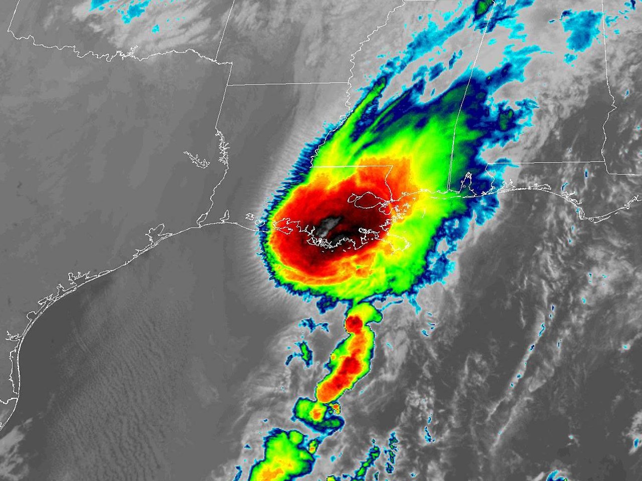
Above: GOES 16 Band 13 Infrared Satellite Image of Post-Tropical Storm Olga coming ashore St. Mary & Terrebonne Parishes in Southern Louisiana at 1:31 AM CDT on October 26, 2019.
During the evening of October 22nd, the National Hurricane Center began monitoring an area of disturbed weather across the Western Caribbean Sea for possible tropical development in the Southwest Gulf of America during the next 5 days. Initially, the disturbance was given a 20% chance of development. Once the disturbance moved into the Southwestern Gulf of America on October 23rd, chances of development increased to 50%, and by the afternoon of the 24th, the chances of development into a tropical cyclone increased to 70%.
By 10 AM October 25th, the system was classified as Tropical Depression Seventeen. A reconnaissance aircraft found that the system had strengthened into Tropical Storm Olga by 4 PM that afternoon with sustained winds of 40 mph. At this time, the reconnaissance aircraft noted the center of the small tropical storm was about 20 miles ahead of a very strong cold front diving southward across the western Gulf of America. Since the National Hurricane Center expected this short-lived tropical storm to be absorbed into the cold front before landfall, it was coordinated with the local National Weather Service offices to handle the marine wind hazards with Small Craft Advisories & Gale Warnings, with the coastal land areas handled with wind advisories & coastal flood advisories. By the evening of the 25th, reconnaissance aircraft found that the circulation of Olga had merged with the strong cold front, being designated Post-Tropical Cyclone Olga by the 10 PM advisory with sustained winds of 50 mph.
So what is a Post-Tropical Cyclone?
The National Hurricane Center defines a Post-Tropical Cyclone as a former tropical cyclone. This generic term describes a cyclone that no longer possesses sufficient tropical characteristics to be considered a tropical cyclone. Post-tropical cyclones can continue carrying heavy rains and high winds. Note that former tropical cyclones that have become fully extratropical, as well as remnant lows, are two classes of post-tropical cyclones.
In this case, Olga transformed into an extratropical cyclone, becoming fully entangled with the cold front as noted by the surface analysis animation below.
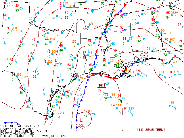
Above: 3 hourly surface analysis animation showing Olga's transformation from a tropical cyclone into a post-tropical cyclone, or in this case, extratropical cyclone, within the strong cold front in the Gulf.
Using the surface analysis above, along with barometer traces from National Ocean Service tide gauges and surface observations, the center of Post-Tropical Cyclone Olga came ashore St. Mary & Terrebonne Parishes in Southern Louisiana between 2-3 AM CDT October 26, 2019. The strongest winds observed with the system was immediately behind the passage of the low within the cold airmass across Vermilion & Atchafalaya Bays, and the coastal waters off the South Central Louisiana coast. Sustained winds of 35-40 knots with gusts of 40-50 knots were measured between Midnight and 2 AM CDT October 26th as the center was passing near several locations offshore South Central Louisiana. A Gale Warning was issued 10 AM Friday October 25th to account for the increased winds as Olga's post-tropical circulation moved north-northeast across South Central Louisiana's coastal waters. The Gale Warning was extended into Saturday morning, with expected winds and seas increased to account for the slightly stronger cyclone. The strongest winds inland were noted across lower St. Mary parish with sustained winds of 25-30 mph with gusts near 35 mph immediately behind Olga's circulation.
Minor coastal flooding of 1-2 feet Mean Higher High Water (MHHW), or a rough estimate of the level above ground level, was noted near high tide along the immediate coast October 25th through around daybreak on the 26th. This was highlighted by Wednesday evening on the 23rd by the issuance of a Coastal Flood Advisory, and continued through the early morning hours of the 26th.
Post-tropical cyclone Olga intensified further after coming ashore Saturday morning October 26th, bringing widespread wind gusts of 40 to 50 mph, with a few gusts as high as 70 mph, over Southeast Louisiana, including New Orleans metro area. Even stronger wind gusts of 75-100 mph were noted across portions of Northern Mississippi, Tennessee, and Kentucky. The intensification of this magnitude was not anticipated by any of the forecast models after it merged with the cold front, and will likely be the subject of future research to anticipate future events.
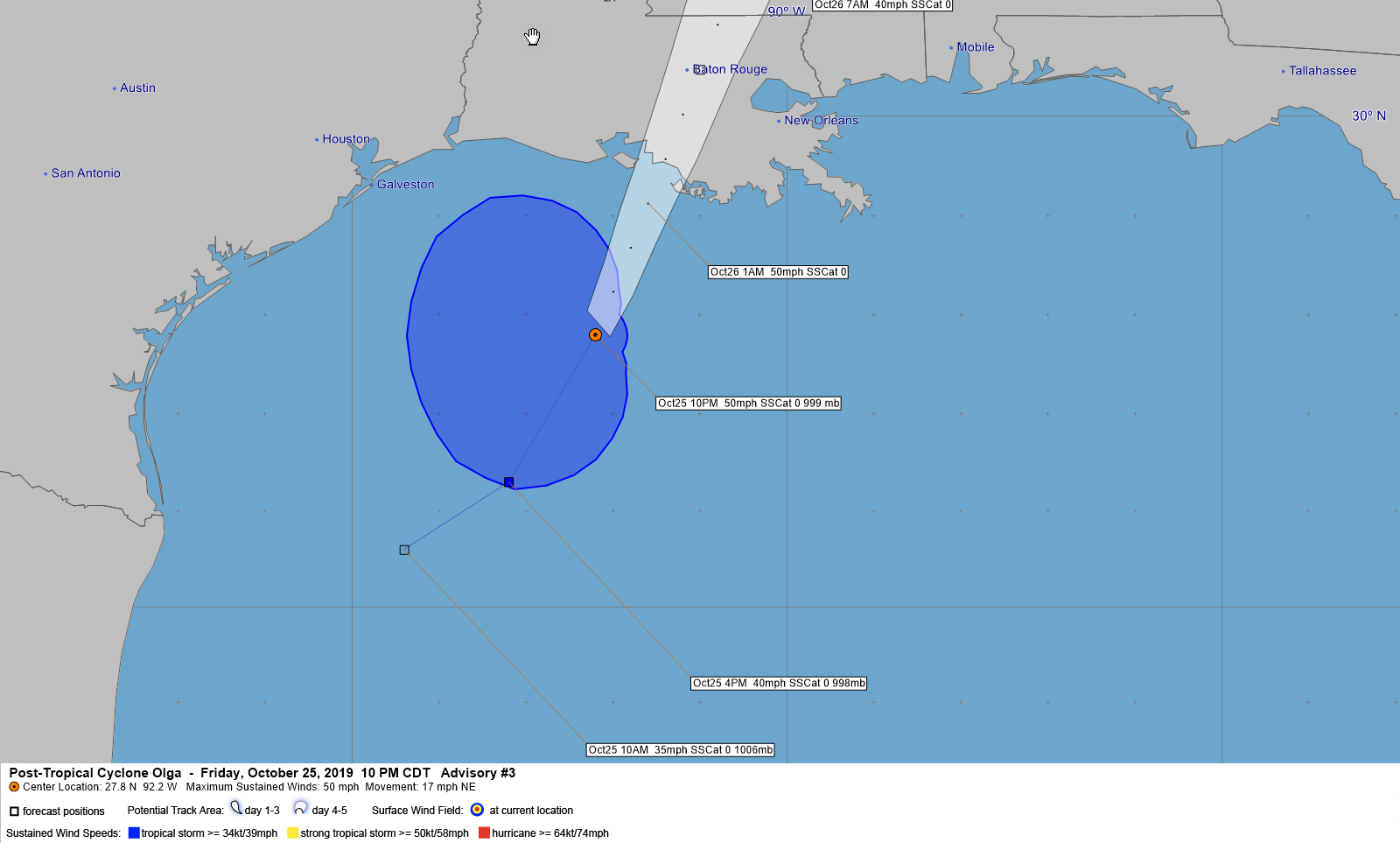
Above: Hurrevac track of Olga from operational National Hurricane Center public advisories.
| NOS Tidal Water Graphs |
| Sabine Pass North, TX |
Texas Point, Sabine Pass, TX |
Port Arthur, TX |
|
| Calcasieu Pass, LA |
Bulk Terminal, LA |
Lake Charles, LA |
Freshwater Canal Locks, LA |
| Eugene Island, LA |
Amerada Pass, LA |
|
|
Webpage design by: Donovan Landreneau
Content by: NWS Lake Charles staff, other sources as noted above.
|


.png)
.png)
.png)
.png)
.png)
.png)
.png)
.png)
.png)
.png)
.png)
.png)
.png)
.png)
.png)
.png)
.png)
.png)
.png)
.png)
.png)
.png)
.png)
.png)