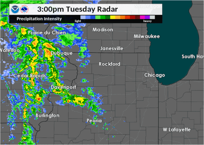
| Cold air had moved into the region during the night of February 4 and warmed little on February 5, with many temperatures at or below freezing as rain moved in late on the 5th. Rain intensity increased into the evening with a switch over to sleet occurring generally north of I-88, especially in the Rockford area. Roads were reported as very poor with a combination of ice and sleet on them. Further south through the I-80 corridor, freezing rain accumulation occurred throughout the evening. Ice accumulation between one tenth to a little over one quarter inch were reported with slick conditions on untreated surfaces. Rainfall amounts were heavier with liquid and liquid equivalent totals of 0.30" to 0.80". There were even embedded thunderstorms with the radar resembling a spring look to it! Due to some of the heavier rates limiting immediate ice accretion, true ice accumulations exceeding one quarter inch were patchy. |
|
Photos
|
|
 |
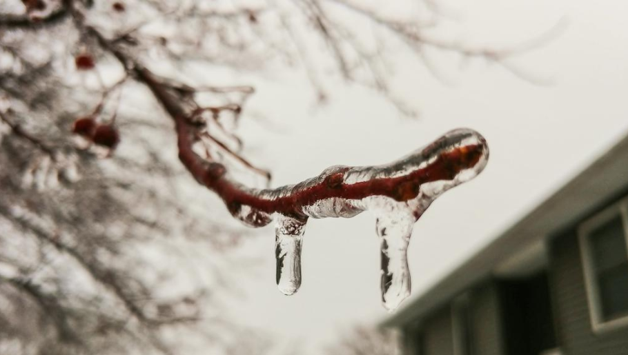
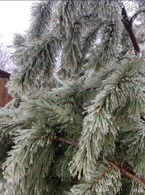
| Photo courtesy of Larry in McHenry, IL. | Photo courtesy of Twitter follower Daltonize13 in Paw Paw, IL |
|
|
 |
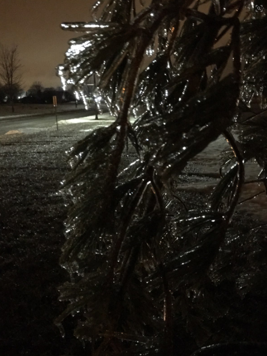 |
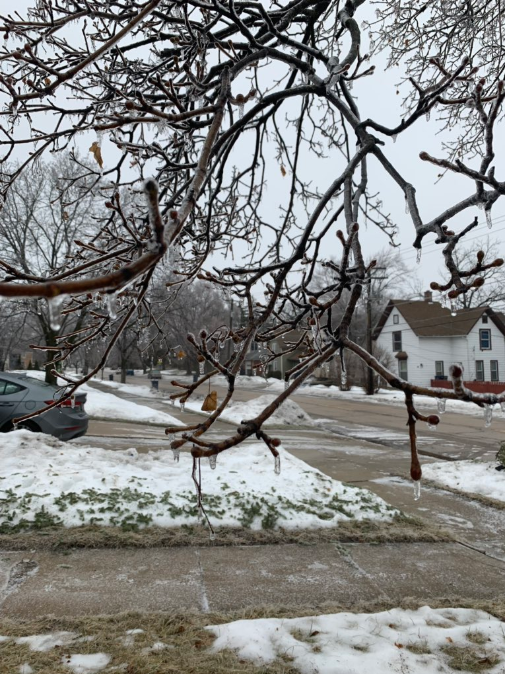
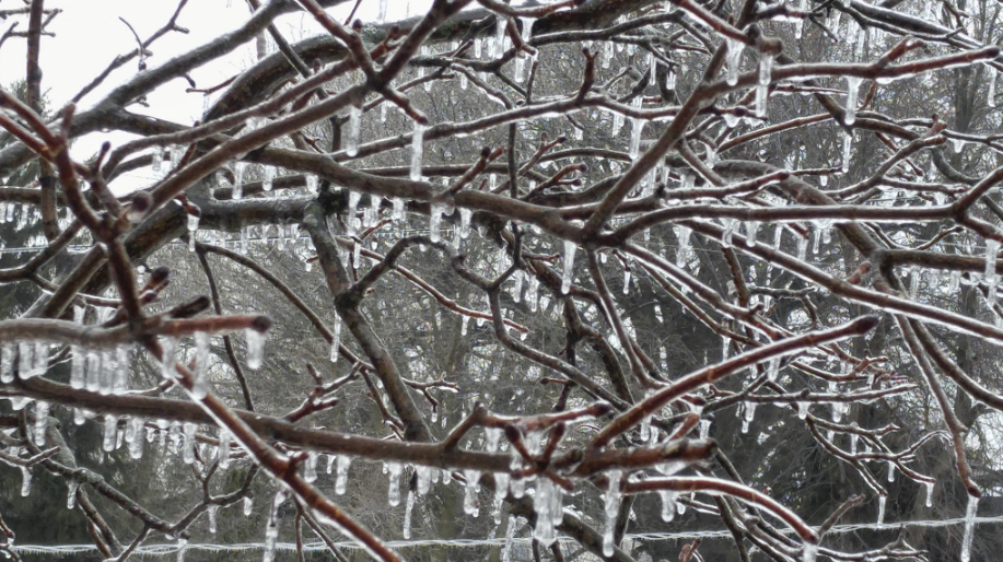
| Photo courtesy of Twitter follower @MidwestStormChaser in Elgin, IL. | Photo courtesy of Twitter follower @MidwestStormChaser in Elgin, IL. | Photo courtesy of John Willis in DeKalb, IL. |
Ice & Sleet Totals
 |
 |
|
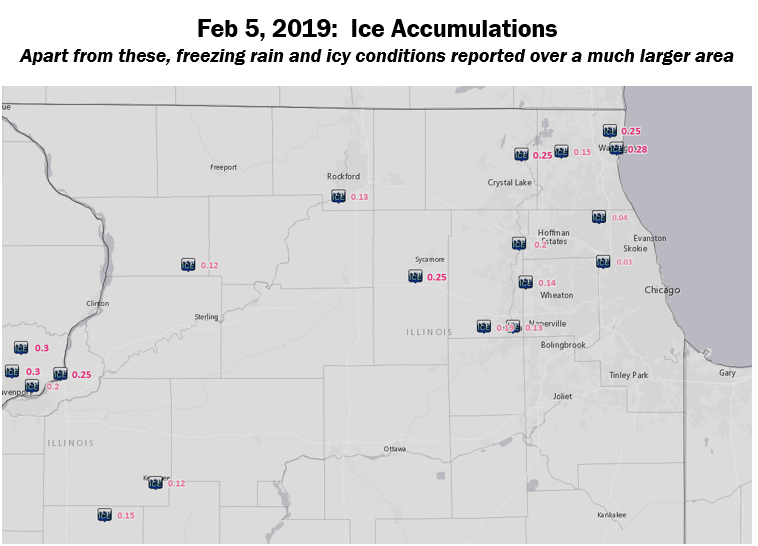
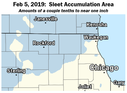
| Ice Accumulations | Sleet Accumulations |
PRELIMINARY LOCAL STORM REPORT...SUMMARY
NATIONAL WEATHER SERVICE CHICAGO IL
448 PM CST WED FEB 6 2019

..TIME...   ...EVENT...      ...CITY LOCATION...     ...LAT.LON...
..DATE...   ....MAG....      ..COUNTY LOCATION..ST.. ...SOURCE....
            ..REMARKS..

0849 AM     FREEZING RAIN    OHARE AIRPORT           41.98N 87.90W
02/06/2019  M0.03 INCH       COOK               IL   ASOS


0848 AM     FREEZING RAIN    WHEELING                42.13N 87.92W
02/06/2019  M0.04 INCH       COOK               IL   ASOS


0847 AM     FREEZING RAIN    DUPAGE AIRPORT          41.91N 88.25W
02/06/2019  M0.14 INCH       DUPAGE             IL   ASOS


0847 AM     FREEZING RAIN    WAUKEGAN                42.36N 87.84W
02/06/2019  M0.28 INCH       LAKE               IL   ASOS


0846 AM     FREEZING RAIN    ROCKFORD AIRPORT        42.20N 89.10W
02/06/2019  M0.13 INCH       WINNEBAGO          IL   ASOS

            SNOW FALL 0.8 INCHES.

0844 AM     FREEZING RAIN    SUGAR GROVE             41.76N 88.44W
02/06/2019  M0.19 INCH       KANE               IL   ASOS


0800 AM     FREEZING RAIN    ELGIN                   42.04N 88.28W
02/06/2019  E0.20 INCH       KANE               IL   TRAINED SPOTTER


0800 AM     FREEZING RAIN    ELGIN                   42.04N 88.28W
02/06/2019  E0.25 INCH       KANE               IL   PUBLIC


0800 AM     FREEZING RAIN    MCHENRY                 42.34N 88.27W
02/06/2019  M0.25 INCH       MCHENRY            IL   PUBLIC


1200 AM     SLEET            ROCKFORD AIRPORT        42.20N 89.10W
02/06/2019  M0.8 INCH        WINNEBAGO          IL   OFFICIAL NWS OBS


1100 PM     FREEZING RAIN    DEKALB                  41.93N 88.75W
02/05/2019  E0.25 INCH       DE KALB            IL   PUBLIC

            ESTIMATED FROM ICE ACCUMULATION ON TREE
            BRANCHES.

1040 PM     FREEZING RAIN    ROCKFORD AIRPORT        42.20N 89.10W
02/05/2019  M0.12 INCH       WINNEBAGO          IL   ASOS


1039 PM     FREEZING RAIN    AURORA                  41.76N 88.31W
02/05/2019  M0.13 INCH       KANE               IL   ASOS


1037 PM     FREEZING RAIN    WHEELING                42.13N 87.92W
02/05/2019  M0.04 INCH       COOK               IL   ASOS


1035 PM     FREEZING RAIN    DUPAGE AIRPORT          41.91N 88.25W
02/05/2019  M0.11 INCH       DUPAGE             IL   ASOS


1034 PM     FREEZING RAIN    OHARE AIRPORT           41.98N 87.90W
02/05/2019  M0.03 INCH       COOK               IL   ASOS


1032 PM     FREEZING RAIN    1 WSW BEACH PARK        42.42N 87.87W
02/05/2019  M0.25 INCH       LAKE               IL   ASOS

            MEASURED BY THE WAUKEGAN ASOS.

0855 PM     SLEET            4 NW CRYSTAL LAKE       42.28N 88.37W
02/05/2019  M0.4 INCH        MCHENRY            IL   CO-OP OBSERVER


0830 PM     FREEZING RAIN    ROUND LAKE              42.35N 88.09W
02/05/2019  M0.15 INCH       LAKE               IL   PUBLIC
Science
 |
 |
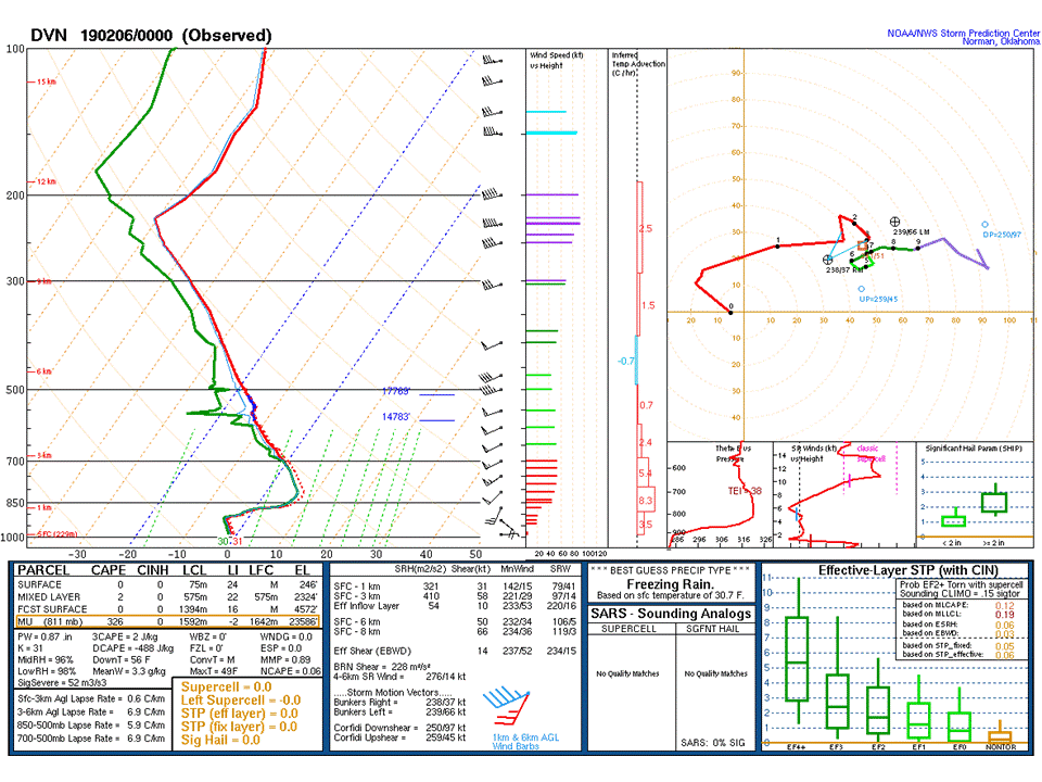 |
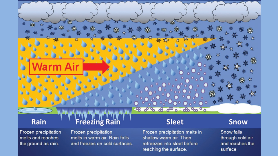
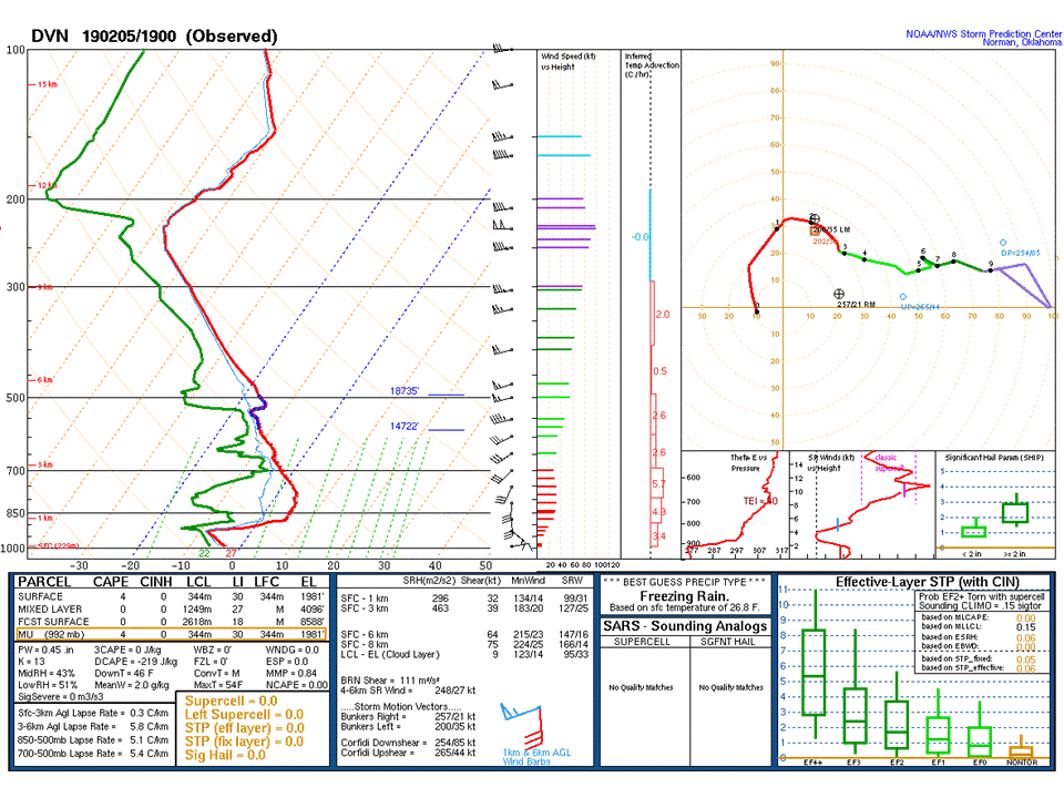
| A simple breakdown of precipitation types. Freezing rain and sleet require warm air atop cold air. This allows for full melting of snow and then the cold air allowing re-freezing either in contact with the surface (freezing rain) or before reaching the ground into ice pellets (sleet). | NWS Quad Cities 12 pm weather balloon launch data. This depicts the atmosphere before the precipitation had moved in and is why still a dry layer is present. Note the warm nose aloft and the strong south winds which are key to keep the layer warm as it begins to moisten. | NWS Quad Cities 6 pm weather balloon launch data. Here the moistened atmosphere is seen with a very high precipitable water for February of 0.87". The warm air aloft (6°C) is still present, sustained by over 50 kt winds in what is referred to as a low-level jet. The cold layer near the surface in this sounding is too shallow to support sleet so freezing rain was occurring in the Quad Cities and points east. Further to the north, such as near Rockford, this near-surface cold layer was deep enough for sleet. Also note some steepened lapse rates that helped support updrafts strong enough for charge separation and lightning. |
 |
Media use of NWS Web News Stories is encouraged! Additional recaps can be found on the NWS Chicago Science & Past Events Page. |
|