
Widespread life-threatening flash and urban flooding continues in south-central Texas, with considerable flooding impacts possible across central Texas. Wildfire smoke is impacting air quality across much of the Great Lakes region into southern New England and the Mid-Atlantic. Monsoonal thunderstorms may produce isolated to scattered flash flooding across the Southwest into the Great Basin. Read More >
Overview
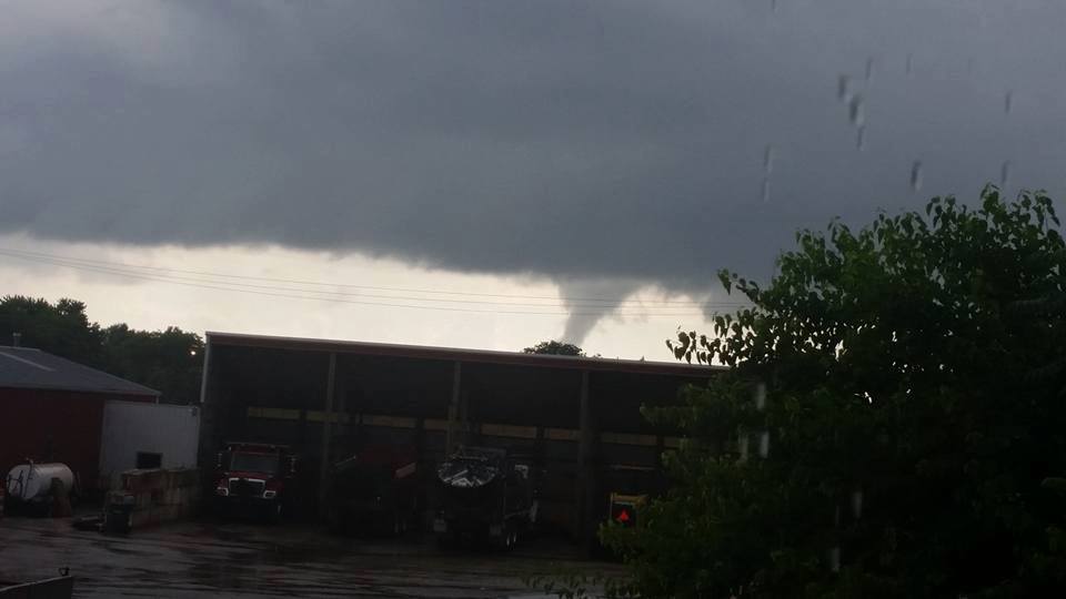
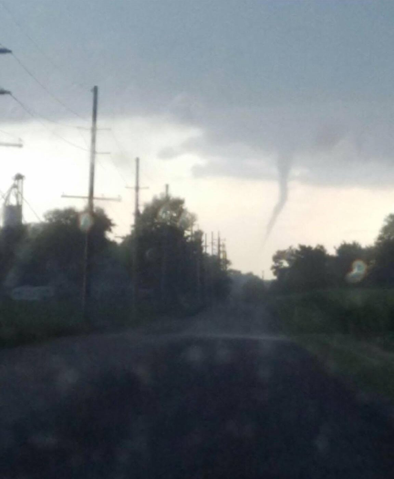
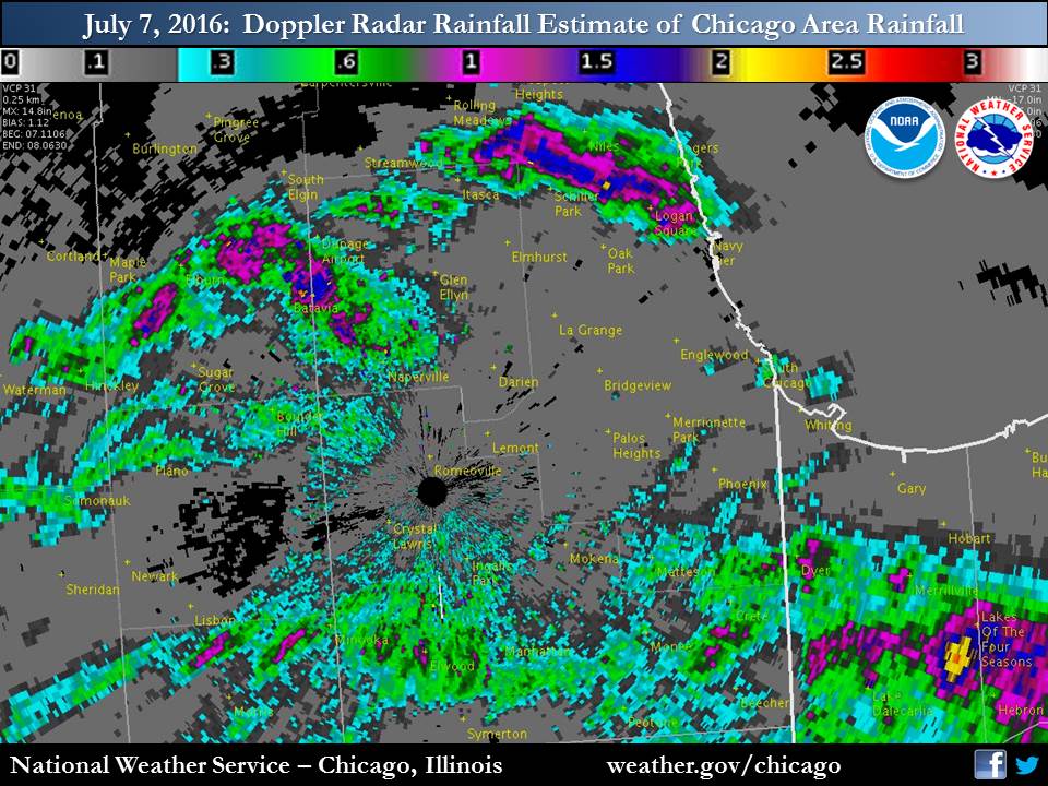
During the late afternoon of Thursday, July 7th, scattered storms developed across northern Illinois and slowly moved east-northeast. As the storms grew, their slow movement helped to produce locally heavy rainfall. The Doppler Radar estimated rainfall maps show the localized nature of the heavy rainfall. In addition, there were a handful of funnel cloud reports from the storms due to large scale rotation in the atmosphere. Concentrated storm rotation for tornadoes was not favored.Photos:
Header
 |
 |
| Funnel Cloud near Yorkville, IL (source Valerie Bank) |
Funnel cloud near Boswell, IN (via Matt Rudkin of WSBT) |
Storm Reports
PRELIMINARY LOCAL STORM REPORT...SUMMARY
NATIONAL WEATHER SERVICE CHICAGO/ROMEOVILLE IL
941 PM CDT THU JUL 07 2016

..TIME...   ...EVENT...      ...CITY LOCATION...     ...LAT.LON...
..DATE...   ....MAG....      ..COUNTY LOCATION..ST.. ...SOURCE....
            ..REMARKS..

0740 PM     FUNNEL CLOUD     S FOWLER                40.62N 87.32W
07/07/2016                   BENTON             IN   EMERGENCY MNGR

            BENTON COUNTY EMERGENCY MANAGER RELAYED REPORTS OF FUNNEL
            CLOUDS...NEAR/SOUTH OF BOSWELL...AND SOUTH OF FOWLER.

0721 PM     HEAVY RAIN       2 NNE HARWOOD HEIGHTS   41.99N 87.79W
07/07/2016  M1.37 INCH       COOK               IL   COCORAHS

            RAIN FELL IN ABOUT ONE HOUR.

0650 PM     HEAVY RAIN       1 SSW PARK RIDGE        42.00N 87.85W
07/07/2016  M1.24 INCH       COOK               IL   COCORAHS

            RAIN FELL IN 40 MINUTES.

0640 PM     HEAVY RAIN       1 ESE ELK GROVE VILLAGE 42.00N 87.97W
07/07/2016  M1.79 INCH       COOK               IL   COCORAHS

            RAIN FELL IN 50 MINUTES. MINOR STREET FLOODING AND
            STANDING WATER IN THE YARD.

0638 PM     HEAVY RAIN       ST. ANNE                41.02N 87.72W
07/07/2016  M1.50 INCH       KANKAKEE           IL   PUBLIC

            RAIN FELL IN ABOUT 40 MINUTES. RELAYED VIA FACEBOOK.

0630 PM     FLOOD            5 NNW CHICAGO           41.94N 87.68W
07/07/2016                   COOK               IL   TRAINED SPOTTER

            ABOUT A FOOT OF WATER ON SOME STREETS NEAR DAMEN AVE AND
            MELROSE ST.

0621 PM     FLOOD            ELK GROVE VILLAGE       42.01N 87.99W
07/07/2016                   COOK               IL   TRAINED SPOTTER

            UP TO 3 INCHES OF WATER IN SOME PARKING LOTS AND POOR
            DRAINAGE AREAS ON ROADWAYS.

0619 PM     FUNNEL CLOUD     5 W LELAND              41.61N 88.89W
07/07/2016                   LA SALLE           IL   TRAINED SPOTTER

            SPOTTER WAS EAST OF LELAND LOOKING TOWARD FUNNEL CLOUD
            PRODUCING SHOWER...WHICH WAS ABOUT 5 MILES WEST OF LELAND
            NEAR LASALLE DEKALB COUNTY LINE.

0615 PM     HEAVY RAIN       S MEDINAH               41.98N 88.06W
07/07/2016  M0.71 INCH       DUPAGE             IL   PUBLIC

            RAIN IN 14 MINUTES ON SOUTH SIDE OF TOWN. REPORT RELAYED
            VIA FACEBOOK.

0524 PM     FLOOD            BATAVIA                 41.85N 88.30W
07/07/2016                   KANE               IL   TRAINED SPOTTER

            STREET FLOODING AT KIRK ROAD AND WILSON. WATER UP TO TOPS
            OF TIRES IN A FEW SPOTS ON TURNING LANES.

0510 PM     FUNNEL CLOUD     S PLANO                 41.66N 88.53W
07/07/2016                   KENDALL            IL   TRAINED SPOTTER

            FUNNEL CLOUD LASTED A FEW MINUTES AND EXTENDED ABOUT HALF
            WAY TO THE GROUND.

0500 PM     FUNNEL CLOUD     YORKVILLE               41.64N 88.45W
07/07/2016                   KENDALL            IL   PUBLIC

            LOOKING WEST AT ABOUT 5PM. RELAYED VIA FACEBOOK.

0455 PM     HEAVY RAIN       MORRIS                  41.37N 88.43W
07/07/2016  M1.02 INCH       GRUNDY             IL   AWOS

            RAIN FELL IN ABOUT 30 MINUTES.


&&

$$

RC
Rain Reports
 |
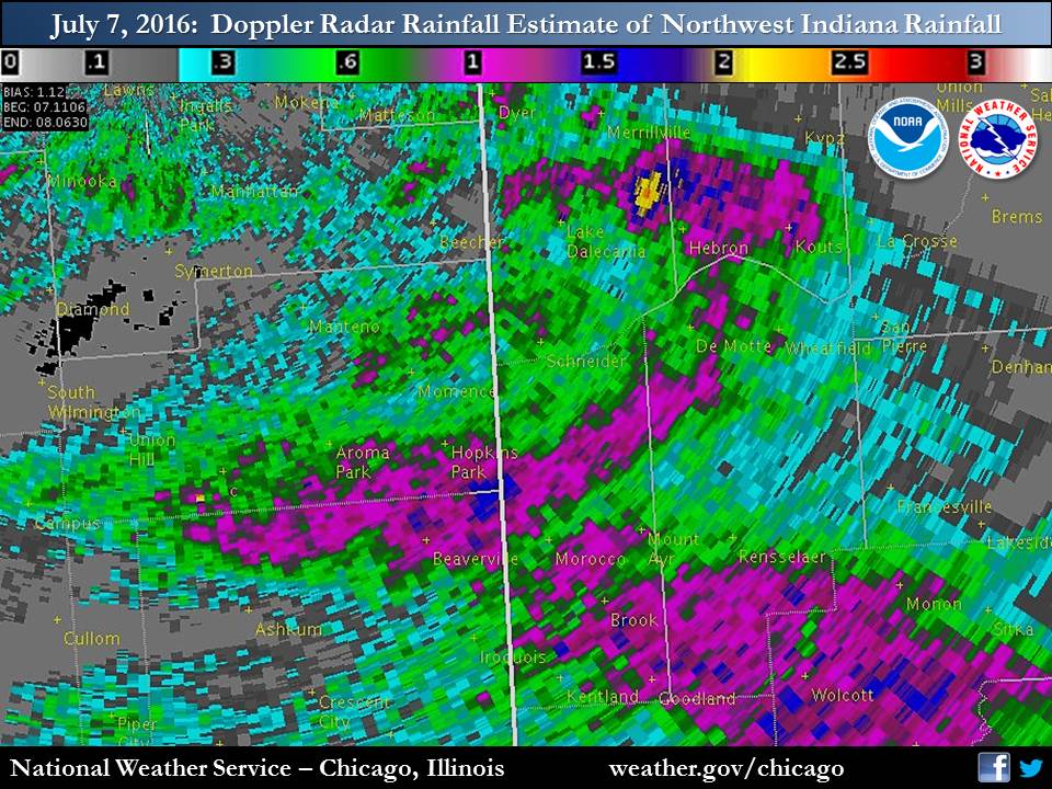 |
| Chicago Area Rainfall | Northwest Indiana Rainfall |
Public Information Statement
National Weather Service Chicago IL
900 AM CDT Fri Jul 08 2016

...Morning Rainfall Roundup...

   The following are rain amounts for the previous 24-hours
   as measured in the morning by NWS Cooperative Observers
   and CoCoRaHS observers.
   Observations are usually taken between 6 AND 8 AM.

   24-hour rainfall amounts
       for Friday(07/08/16)...


Illinois                                       Rain
  Location (County):                           fall (inches)

  Chicago 6NNE (Cook)..........................1.97
  Harwood Heights 2NNE (Cook)..................1.37
  Park Ridge (Cook)............................1.28
  St Anne (Kankakee)...........................1.25
  Chebanse (Kankakee)..........................1.06
  Ohare (Cook).................................1.05
  Morris (Grundy)..............................1.04
  Plano (Kendall)..............................1.02
  Channahon 2SSE (Will)........................1.00
  Aurora 4NE (Du Page).........................0.93
  West Chicago (Du Page).......................0.85
  Elburn (Kane)................................0.84
  Naperville 1NW (Du Page).....................0.77
  Momence (Kankakee)...........................0.75
  Geneva 1SSW (Kane)...........................0.66
  Lisle (Du Page)..............................0.59
  Elwood 5NE (Will)............................0.58
  Lincolnwood 2E (Cook)........................0.56
  Morris 5NNW (Grundy).........................0.55
  New Lenox 2SE (Will).........................0.54
  Rogers Park 2SW (Cook).......................0.53
  Batavia 2WNW (Kane)..........................0.53
  Batavia 1WNW (Kane)..........................0.52
  Kankakee (Kankakee)..........................0.51
  Mazon 0.5ENE (Grundy)........................0.51
  Bartlett 1SE (Du Page).......................0.47
  Crete 3E (Will)..............................0.46
  Morris 2SSE (Grundy).........................0.45
  Naperville 2ESE (Du Page)....................0.44
  Montgomery 1SSE (Kendall)....................0.43
  Aurora 4SE (Du Page).........................0.42
  Peotone (Will)...............................0.39
  Lincolnwood 3E (Cook)........................0.36
  Watseka (Iroquois)...........................0.36
  Bonfield 4WSW (Kankakee).....................0.35
  Lockport 1SE (Will)..........................0.32
  Wilmington 6NW (Will)........................0.30
  Naperville 4SSW (Will).......................0.28
  Lisle Morton Arb (Du Page)...................0.28
  Somonauk 2NE (De Kalb).......................0.27
  Roselle 1W (Du Page).........................0.26
  New Lenox 3E (Will)..........................0.25
  Geneva 4WSW (Kane)...........................0.23
  Joliet (Will)................................0.23
  Plainfield (Will)............................0.23
  Bourbonnais (Kankakee).......................0.22
  Carol Stream (Du Page).......................0.20
  Lockport 3ESE (Will).........................0.20
  Romeoville (Will)............................0.20
  Morris 2N (Grundy)...........................0.19
  Glen Ellyn (Du Page).........................0.18
  Plainfield 1SW (Will)........................0.18
  Joliet 2n (Will).............................0.18
  Park Forest (Cook)...........................0.17
  Plainfield 5SW (Kendall).....................0.16
  Marseilles 5WNW (La Salle)...................0.16
  Park Forest 1SW (Cook).......................0.15
  Elk Grove Village 2WSW (Cook)................0.15
  Naperville 2SE (Du Page).....................0.14
  Manhattan (Will).............................0.14
  Morris (Grundy)..............................0.14
  Winfield (Du Page)...........................0.14
  Aurora (Kane)................................0.13
  Oak Park 1NNE (Cook).........................0.13
  Downers Grove 0.4NNE (Du Page)...............0.13
  Downers Grove 1S (Du Page)...................0.13
  Ashkum 5.6E (Iroquois).......................0.13
  North Aurora 2NE (Kane)......................0.13
  Chatsworth (Livingston)......................0.12
  Coal City 4NNW (Grundy)......................0.12
  Carbon Hill 3.1N (Grundy)....................0.12
  Watseka 6.9WNW (Iroquois)....................0.12
  Lily Lake 2E (Kane)..........................0.12
  Chatsworth (Livingston)......................0.12
  Plainfield 2SSE (Will).......................0.12
  Milford (Iroquois)...........................0.11
  Polo (Ogle)..................................0.11
  Batavia (Kane)...............................0.10
  Sugar Grove 1NE (Kane).......................0.10
  Aurora (Kane)................................0.09
  Beecher 3SSE (Will)..........................0.09
  Westmont (Du Page)...........................0.09
  Lansing (Cook)...............................0.08
  Chicago 6ESE (Cook)..........................0.08
  Park Forest 1NNE (Cook)......................0.08
  Dwight (Livingston)..........................0.06
  Sterling 4NE (Lee)...........................0.06
  Earlville 3S (La Salle)......................0.05
  Oak Lawn (Cook)..............................0.05
  Bolingbrook 3NE (Du Page)....................0.05
  Elmhurst 2SE (Du Page).......................0.05
  Homer Glen 1ENE (Will).......................0.05
  Chicago Ridge (Cook).........................0.04
  Sheridan 3SSE (La Salle).....................0.04
  Byron 3N (Ogle)..............................0.04
  Midway (Cook)................................0.04
  Worth (Cook).................................0.03
  Countryside 1ENE (Cook)......................0.03
  Elmhurst (Du Page)...........................0.03
  Burr Ridge 2SW (Du Page).....................0.03
  Oswego 5SSE (Kendall)........................0.03
  Dixon 3NNW (Lee).............................0.03
  Amboy (Lee)..................................0.03
  Streator 4ENE (La Salle).....................0.03
  Ottawa (La Salle)............................0.03
  St. Charles 6NW (Kane).......................0.02
  Dixon 2SW (Lee)..............................0.02
  Wilmington 3SE (Will)........................0.02
  Paxton (Ford)................................0.02
  Rochelle (Ogle)..............................0.02
  Willow Springs (Cook)........................0.02
  De Kalb (De Kalb)............................0.01
  Gibson 3WNW (Ford)...........................0.01
  Dwight 4NNW (Grundy).........................0.01
  Lisbon 4NE (Kendall).........................0.01
  Ashton (Lee).................................0.01
  Beach Park 1W (Lake).........................0.01
  Ottawa 2N (La Salle).........................0.01
  La Salle (La Salle)..........................0.01
  Mendota 2SE (La Salle).......................0.01
  Midway Coop (Cook)...........................0.01
  Wheeling (Cook)..............................0.01
  Rockford (Winnebago).........................0.01
  Steward (Lee)................................0.01
  De Kalb (De Kalb)...........................TRACE
  Capron (Boone)..............................TRACE
  Glencoe (Cook)..............................TRACE
  Gibson 6NE (Ford)...........................TRACE
  Braceville (Grundy).........................TRACE
  Elgin 2W (Kane).............................TRACE
  Gurnee 2NE (Lake)...........................TRACE
  Lake Villa 1SSW (Lake)......................TRACE
  Waukegan 2N (Lake)..........................TRACE
  Ottawa 1NW (La Salle).......................TRACE
  Waukegan (Lake).............................TRACE

Indiana                                        Rain
  Location (County):                           fall (inches)

  Remington (Jasper)...........................1.84
  Lake Village 8SE (Newton)....................1.55
  Lake Village (Newton)........................1.31
  Wheatfield 5W (Jasper).......................1.15
  Remington (Jasper)...........................1.10
  Crown Point 2WSW (Lake)......................1.10
  De Motte 4SW (Jasper)........................1.05
  Winfield 1NE (Lake)..........................1.05
  De Motte 1NNW (Jasper).......................1.03
  Valparaiso 6S (Porter).......................0.99
  Rensselaer 2SSW (Jasper).....................0.91
  De Motte 6S (Jasper).........................0.90
  De Motte 1SSW (Jasper).......................0.90
  Brook 4W (Newton)............................0.85
  Morocco (Newton).............................0.82
  Rensselaer (Jasper)..........................0.82
  Dyer 1WNW (Lake).............................0.76
  (w9mal)Merrillville 2NNW (Lake)..............0.71
  Crown Point (Lake)...........................0.69
  Fair Oaks 6SW (Newton).......................0.68
  Valparaiso 6SSW (Porter).....................0.64
  (w9opr)Wheatfield 1ENE (Jasper)..............0.60
  Valparaiso 7WSW (Porter).....................0.59
  Rensselaer 10NNE (Jasper)....................0.58
  Rensselaer 2N (Jasper).......................0.55
  Crown Point 1N (Lake)........................0.55
  Rensselaer 5NW (Jasper)......................0.54
  (kb9f)Valparaiso 4S (Porter).................0.54
  Valparaiso 6WSW (Porter).....................0.54
  Rensselaer 8ENE (Jasper).....................0.50
  Lake Village 2W (Newton).....................0.48
  Kentland 2SSE (Newton).......................0.40
  Wheatfield 3S (Jasper).......................0.33
  Rensselaer 8NE (Jasper)......................0.20
  Gary 4SSW (Lake).............................0.20
  Valparaiso 2NW (Porter)......................0.20
  Valparaiso 1NNW (Porter).....................0.18
  Valparaiso 3WSW (Porter).....................0.17
  Valparaiso (Porter)..........................0.12
  Hobart 1NNW (Lake)...........................0.08
  (wv90)Hobart 1ENE (Lake).....................0.07
  Gary 5ENE (Lake).............................0.03
  Portage 1ESE (Porter)........................0.02

$$
Additional Information
Summaries from Other NWS Offices
 |
Media use of NWS Web News Stories is encouraged! Please acknowledge the NWS as the source of any news information accessed from this site. |
|

