Overview
|
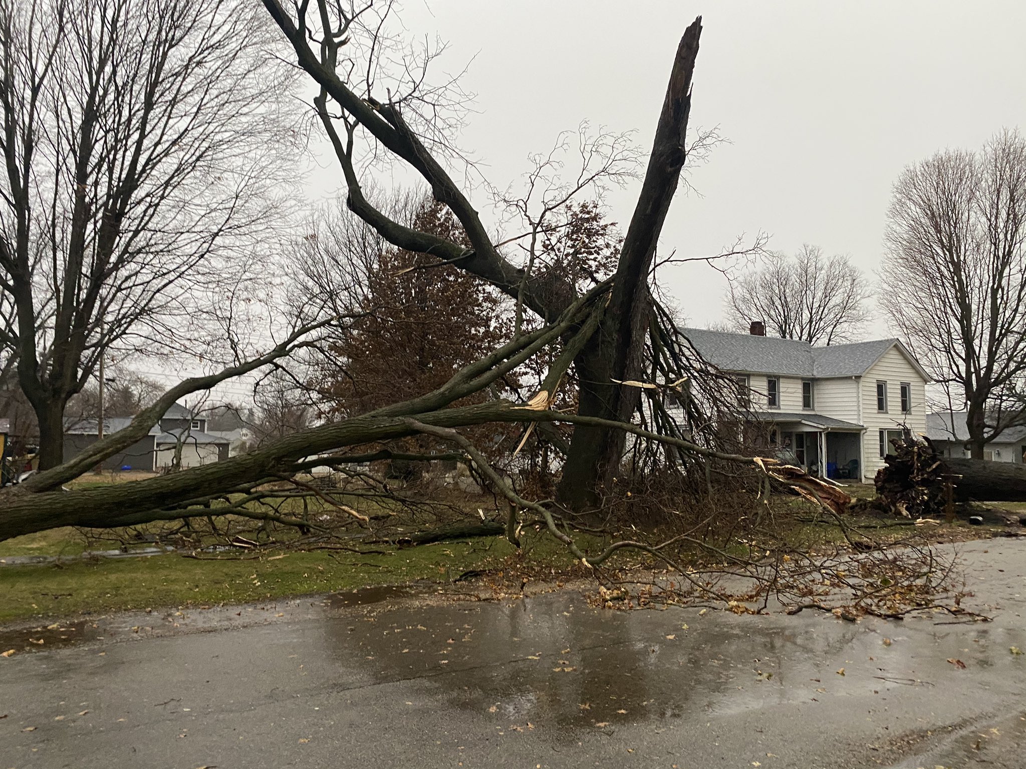
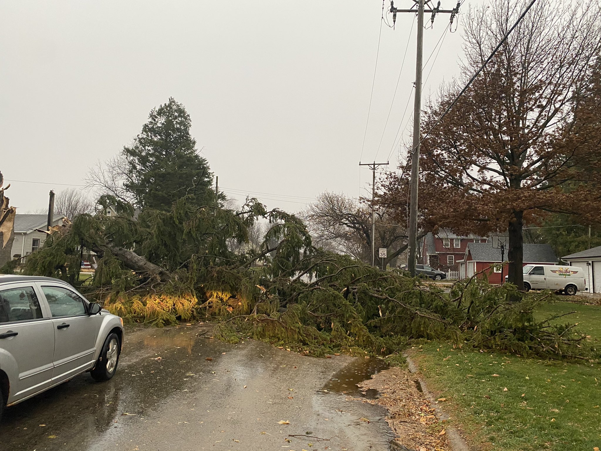
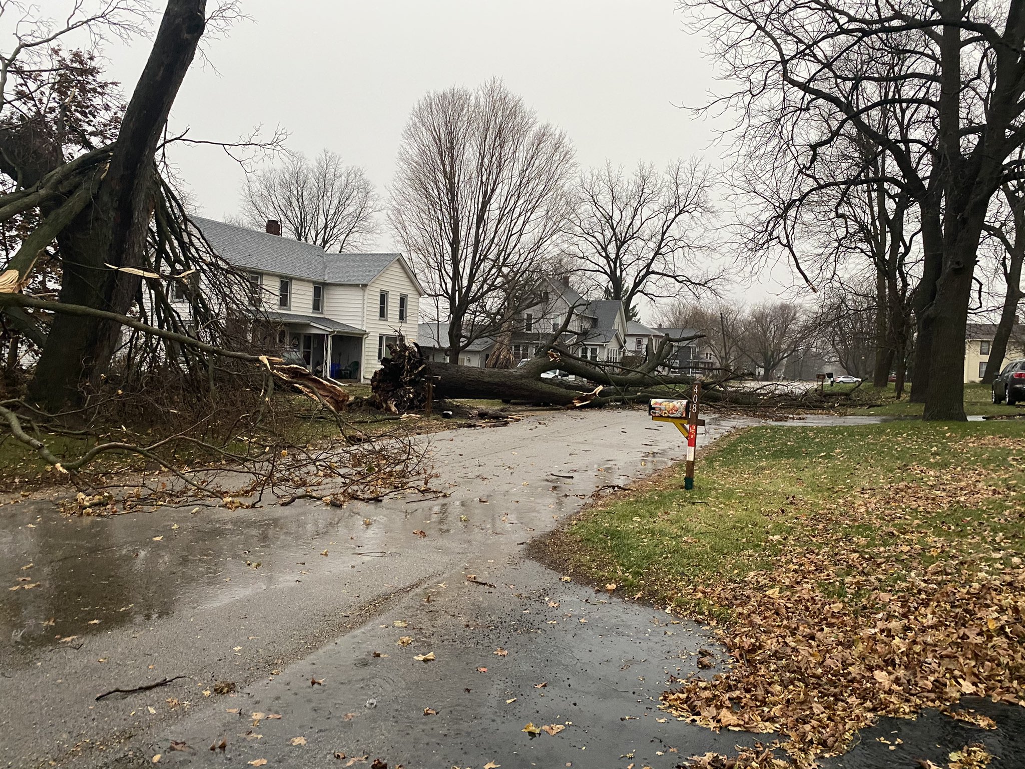
Fast Facts: A strengthening low pressure system caused strong winds ahead of and behind a powerful cold front on Tuesday, November 10th. In addition, a fast moving line of severe thunderstorms moved across the area from mid-afternoon through the early evening. The line of severe thunderstorms produced numerous observed severe wind gusts, some significant. There were pockets of extensive wind damage, and two EF-0 tornadoes occurred in DeKalb and Kane counties. Furthermore, hail larger than quarter size (1" in diameter) was observed in portions of Winnebago County. The DeKalb and Kane County EF-0 tornadoes are the first November tornadoes to occur in NWS Chicago's County Warning Area (CWA) since 10 tornadoes touched down or crossed into the CWA during the November 17, 2013 tornado outbreak. Dating back to 1950, there have now been a total of 23 tornadoes to occur in the NWS Chicago CWA during the month of November. |
.png) Summary of the storm reports received on November 10th, 2020 |
Storm Reports
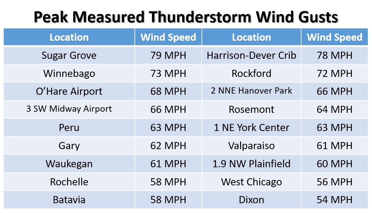 |
| Strongest measured thunderstorm wind gusts from a variety of sources |
|
|
|
 |
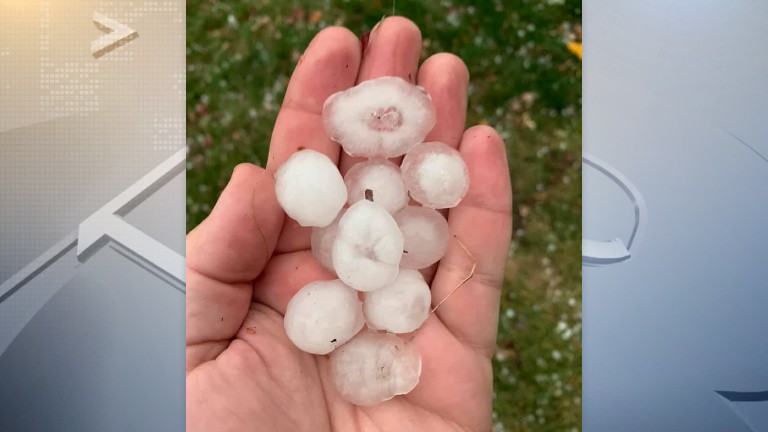
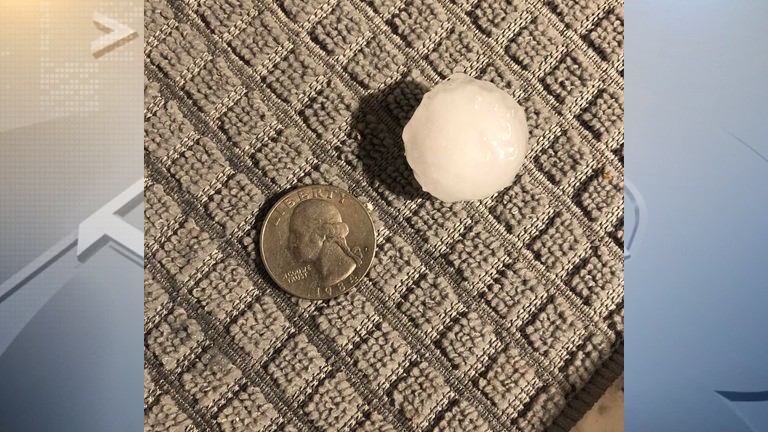
| Large hail in the Rockford area. Relayed via WREX, and Jon. | Hail in the Rockford area. Relayed via WREX, and Riley. | Wind damage near Mt. Morris - Courtesy of Kellie and John Call, relayed via WREX |
 |
 |
 |
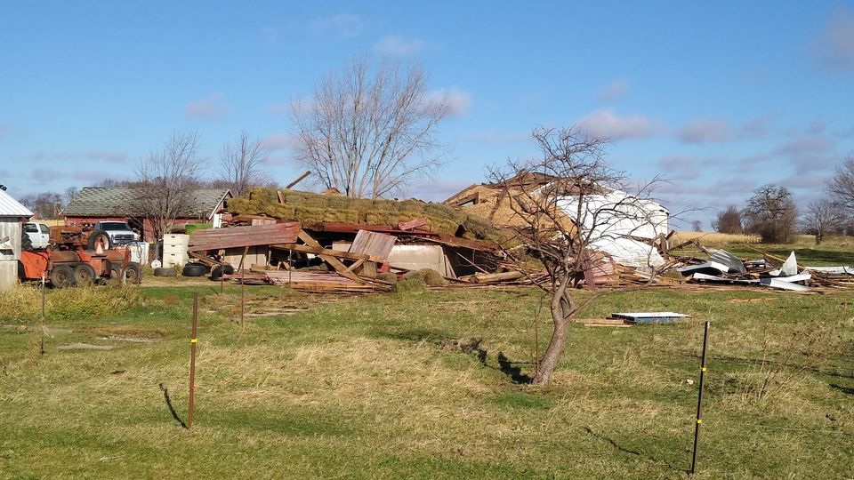
| Wind damage in Winnebago - Courtesy of Patrick Murray and Kaylee Woolery | Wind damage in Winnebago - Courtesy of Patrick Murray and Kaylee Woolery | Wind damage in Winnebago - Courtesy of Patrick Murray and Kaylee Woolery |
 |
|
|
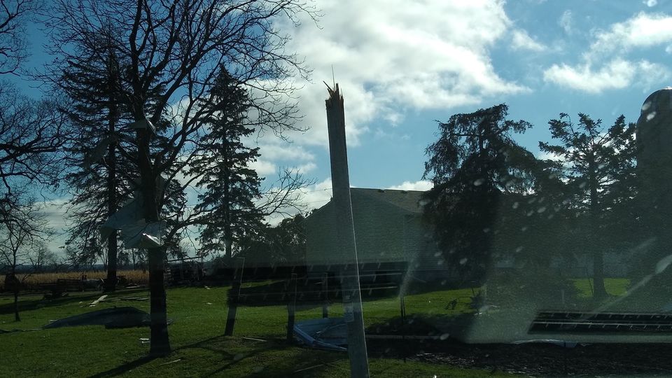
| Wind damage in Boone County north of Capron - Courtesy of Emilie Elliott | Wind damage along the Illinois-Wisconsin state line northwest of Harvard - Courtesy of Meaghan McLoughlin Zeiner | Wind damage along the Illinois-Wisconsin state line northwest of Harvard - Courtesy of Meaghan McLoughlin Zeiner |
Preliminary Local Storm Report Summary
NATIONAL WEATHER SERVICE CHICAGO IL
118 PM CST FRI NOV 13 2020
..TIME... ...EVENT... ...CITY LOCATION... ...LAT.LON...
..DATE... ....MAG.... ..COUNTY LOCATION..ST.. ...SOURCE....
..REMARKS..
0312 PM TSTM WND GST DIXON 41.84N 89.48W
11/10/2020 M54 MPH LEE IL TRAINED SPOTTER
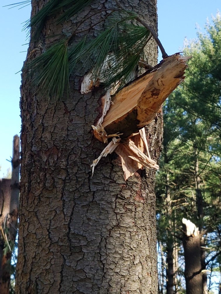
0316 PM TSTM WND DMG 2 SW MOUNT MORRIS 42.03N 89.47W
11/10/2020 OGLE IL BROADCAST MEDIA
DOZENS OF TREES DAMAGED OR DOWNED. PHOTO
RELAYED BY WREX SHOWS A LARGE CHUNK OF WOOD
FROM ONE TREE IMPALED THROUGH ANOTHER TREE.
TIME ESTIMATED BY RADAR.
0331 PM TSTM WND DMG 2 WNW WINNEBAGO 42.28N 89.27W
11/10/2020 WINNEBAGO IL TRAINED SPOTTER
TWO BOX TRUCKS FLIPPED OVER IN A DITCH ALONG
HIGHWAY 20 JUST WEST OF WINNEBAGO. ALSO SOME
SILO DAMAGE WAS NOTED. TIME ESTIMATED BY
RADAR.
0332 PM TSTM WND GST WINNEBAGO 42.27N 89.24W
11/10/2020 M73 MPH WINNEBAGO IL TRAINED SPOTTER
ALSO REPORTED PENNY TO QUARTER SIZED HAIL
BRIEFLY.
0332 PM TSTM WND DMG WINNEBAGO 42.27N 89.24W
11/10/2020 WINNEBAGO IL TRAINED SPOTTER
EXTENSIVE DAMAGE; MULTIPLE TREES BLOWN OVER,
MANY ONTO CARS; CAR WINDOWS BROKEN.
0337 PM TSTM WND GST ROCKFORD AIRPORT 42.20N 89.10W
11/10/2020 M72 MPH WINNEBAGO IL ASOS
ASOS STATION KRFD ROCKFORD AIRPORT.
0340 PM TSTM WND GST 4 ENE WINNEBAGO 42.30N 89.17W
11/10/2020 E65 MPH WINNEBAGO IL BROADCAST MEDIA
0340 PM TSTM WND DMG 6 NNE WINNEBAGO 42.35N 89.18W
11/10/2020 WINNEBAGO IL EMERGENCY MNGR
DELAYED REPORT. GRAIN SILO AND BARN
COLLAPSED, KILLING TWO CATTLE. TIME
ESTIMATED BY RADAR. RELAYED VIA EMERGENCY
MANAGER AND LOCAL MEDIA.
0340 PM TSTM WND DMG 2 NW ROCKFORD 42.29N 89.11W
11/10/2020 WINNEBAGO IL PUBLIC
1-INCH TREE LIMBS BROKEN; SHINGLES BLOWN
OFF. ALSO, PENNY SIZE HAIL.
0340 PM TSTM WND GST BYRON 42.13N 89.26W
11/10/2020 E70 MPH OGLE IL PUBLIC
WHOLE TREES DOWNED AND DAMAGE TO POWER
LINES. RELAYED VIA SOCIAL MEDIA.
0345 PM HAIL ROSCOE 42.41N 89.00W
11/10/2020 M1.00 INCH WINNEBAGO IL PUBLIC
SEVERAL REPORTS OF 1 INCH HAIL.
0346 PM HAIL 1 N ROCKTON 42.46N 89.07W
11/10/2020 E1.25 INCH WINNEBAGO IL BROADCAST MEDIA
PHOTO OF VINYL SIDING OF HOME DAMAGED BY
WHAT APPEARS TO BE WIND DRIVEN HAIL. HAIL
SIZE ESTIMATED. ESTIMATED WINDS OF 70 MPH.
0346 PM TSTM WND GST ROSCOE 42.41N 89.01W
11/10/2020 E70 MPH WINNEBAGO IL PUBLIC
NUMEROUS LARGE TREE BRANCHES DOWN. TIME
ESTIMATED BY RADAR.
0346 PM HAIL 1 SE ROSCOE 42.40N 89.00W
11/10/2020 E1.00 INCH WINNEBAGO IL PUBLIC
0347 PM HAIL 2 E ROCKFORD 42.27N 89.06W
11/10/2020 E0.25 INCH WINNEBAGO IL TRAINED SPOTTER
REPORTED AT 2400 E STATE ST, ROCKFORD, IL.
0348 PM HAIL 5 W MACHESNEY PARK 42.37N 89.13W
11/10/2020 E0.50 INCH WINNEBAGO IL PUBLIC
HALF-INCH (0.50 IN.).
0348 PM HAIL ROCKFORD 42.27N 89.09W
11/10/2020 E0.50 INCH WINNEBAGO IL TRAINED SPOTTER
0355 PM TSTM WND GST 2 SSW ROCHELLE 41.89N 89.08W
11/10/2020 M58 MPH OGLE IL AWOS
AWOS STATION KRPJ ROCHELLE AIRPORT.
0355 PM TSTM WND GST 3 NNW PERU 41.36N 89.15W
11/10/2020 E70 MPH LA SALLE IL PUBLIC
RELAYED VIA SOCIAL MEDIA.
0355 PM TSTM WND GST DUPAGE AIRPORT 41.92N 88.25W
11/10/2020 M56 MPH DUPAGE IL ASOS
ASOS STATION KDPA WEST CHICAGO - DUPAGE
ARPT.
0355 PM TSTM WND DMG 1 S POPLAR GROVE 42.35N 88.82W
11/10/2020 BOONE IL LAW ENFORCEMENT
NUMEROUS REPORTS OF DOWNED TREES AND WIRES
ACROSS BOONE COUNTY.
0355 PM TSTM WND GST POPLAR GROVE 42.37N 88.82W
11/10/2020 E70 MPH BOONE IL AMATEUR RADIO
ESTIMATED 70 MPH WINDS FOR FIVE MINUTES WITH
PEA SIZE HAIL.
0358 PM TSTM WND DMG 2 SW BELVIDERE 42.24N 88.87W
11/10/2020 BOONE IL LAW ENFORCEMENT
ABOUT 30 SQUARE FEET OF ROOF TORN OFF THE
CHRYSLER PLANT IN BELVIDERE. TIME ESTIMATED
BY RADAR.
0400 PM TSTM WND GST 2 NW PERU 41.35N 89.15W
11/10/2020 M63 MPH LA SALLE IL AWOS
ILLINOIS VALLEY REGIONAL AIRPORT - KVYS.
0400 PM TSTM WND DMG 2 SW BELVIDERE 42.23N 88.86W
11/10/2020 BOONE IL PUBLIC
DAMAGE TO POWER POLES. TIME ESTIMATED BY
RADAR.
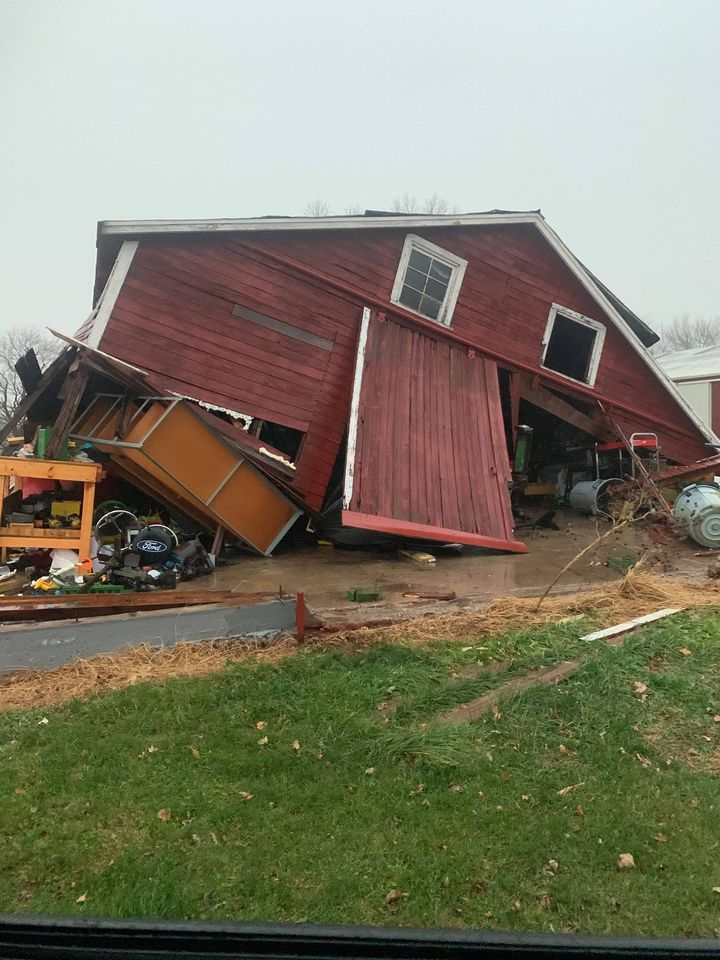
0402 PM TSTM WND DMG 5 NNE CAPRON 42.47N 88.70W
11/10/2020 MCHENRY IL PUBLIC
SEVERAL BARNS AND OUTBUILDINGS COMPROMISED
BY STRONG WINDS, CAUSING THEIR DOORS AND/OR
ROOFS TO BE BLOWN OFF. A FEW OF THESE
STRUCTURES WERE ALSO BLOWN OFF THEIR
FOUNDATIONS AND/OR COLLAPSED. PEAK WINDS
ESTIMATED TO BE BETWEEN 70 AND 80 MPH.
0405 PM TSTM WND GST MENDOTA 41.55N 89.12W
11/10/2020 E65 MPH LA SALLE IL NWS EMPLOYEE
ESTIMATED 60 TO 70 MPH WIND GUSTS.
0405 PM TSTM WND DMG 3 NW TRIUMPH 41.53N 89.06W
11/10/2020 LA SALLE IL NEWSPAPER
SEMI BLOWN OVER ON I-39 NEAR MENDOTA. TIME
ESTIMATED BY RADAR.
0419 PM TORNADO 5 SSW HINCKLEY 41.71N 88.69W
11/10/2020 DE KALB IL NWS STORM SURVEY
BASED ON RADAR DATA, SPOTTER REPORTS, AND
INPUT FROM EMERGENCY MANAGEMENT OFFICIALS,
AN EF-0 TORNADO WITH PEAK WINDS OF 80 MPH,
PATH LENGTH OF 10 MILES, AND MAX WIDTH OF 50
YARDS TOUCHED DOWN IN RURAL DEKALB COUNTY
NORTHWEST OF SOMONAUK AND CONTINUED
NORTHEAST INTO FARM FIELDS. A GRAIN SILO WAS
DAMAGED AND POWER LINES WERE DOWNED ALONG
THE PATH OF THE TORNADO BEFORE IT LIFTED
NEAR HINCKLEY.
0421 PM TSTM WND DMG 2 NW MALTA 41.95N 88.89W
11/10/2020 DE KALB IL TRAINED SPOTTER
DAMAGE TO A POWER POLE, LEFTING HANGING OVER
A ROADWAY.
0432 PM TSTM WND GST 2NW SERENA 41.50N 88.73W
11/10/2020 U76 MPH LA SALLE IL TRAINED SPOTTER
76 MPH MEASURED WIND GUST. 3-5 MINUTE
DURATION OF 60-70 MPH WINDS.
0433 PM TSTM WND DMG 1 SW KANEVILLE 41.82N 88.53W
11/10/2020 KANE IL PUBLIC
SMALL TREE LIMBS BROKEN AND DAMAGE TO POWER
LINES. TIME ESTIMATED BY RADAR.
0434 PM TSTM WND DMG 1 S DEKALB 41.91N 88.75W
11/10/2020 DE KALB IL TRAINED SPOTTER
REPORTED AT 1407 S 4TH ST, DEKALB, IL
MULTIPLE POWERLINE POLES AND ASSOCIATED
POWER LINES DOWN.
0439 PM TSTM WND GST 2 W SUGAR GROVE 41.77N 88.48W
11/10/2020 M79 MPH KANE IL ASOS
ASOS STATION KARR SUGAR GROVE - AURORA ARPT.
0439 PM TORNADO 1 S LILY LAKE 41.93N 88.48W
11/10/2020 KANE IL NWS STORM SURVEY
BASED ON RADAR DATA AND SPOTTER REPORTS, A
BRIEF EF-0 TORNADO WITH PEAK WINDS OF 80
MPH, PATH LENGTH OF 4 MILES, AND MAX WIDTH
OF 50 YARDS TOUCHED DOWN NEAR LILY LAKE
PRODUCING ROOF DAMAGE TO AN OUTBUILDING AND
NEARBY TREES.
0448 PM TSTM WND DMG 1 SSW KANEVILLE 41.82N 88.53W
11/10/2020 KANE IL TRAINED SPOTTER
MULTIPLE POWER POLES DOWN. TIME ESTIMATED.
0449 PM TSTM WND GST 1 W BATAVIA 41.85N 88.33W
11/10/2020 M58 MPH KANE IL EMERGENCY MNGR
MEASURED AT BATAVIA ESDA EOC.
0450 PM TSTM WND DMG 1 WSW LAKE IN THE HILLS 42.18N 88.35W
11/10/2020 MCHENRY IL EMERGENCY MNGR
SIDING STRIPPED OFF OF A BUILDING IN LAKE IN
THE HILLS. TIME ESTIMATED BY RADAR.
0450 PM TSTM WND GST 3 SSE KANEVILLE 41.80N 88.50W
11/10/2020 E70 MPH KANE IL TRAINED SPOTTER
ESTIMATED 70+ MPH WIND GUSTS AND DIME SIZE
HAIL.
0450 PM TSTM WND GST 2 NE CAMPTON HILLS 41.96N 88.37W
11/10/2020 E60 MPH KANE IL BROADCAST MEDIA
60+ MPH WIND GUSTS AND PEA SIZE HAIL.
0455 PM TSTM WND DMG 1 WSW TROUT VALLEY 42.19N 88.27W
11/10/2020 MCHENRY IL LAW ENFORCEMENT
LARGE BRANCHES, TREES, AND POWER LINES
DOWNED ACROSS PORTIONS OF SOUTHEASTERN
MCHENRY COUNTY.
0457 PM TSTM WND DMG ANTIOCH 42.48N 88.10W
11/10/2020 LAKE IL PUBLIC
FENCES BLOWN DOWN AND TREES UPROOTED IN
ANTIOCH. TIME ESTIMATED BY RADAR.
0503 PM TSTM WND DMG 2 E SHABBONA 41.76N 88.83W
11/10/2020 DE KALB IL PUBLIC
3-INCH TREE LIMBS BROKEN; DAMAGE TO POWER
POLES.
0506 PM TSTM WND GST 2 SE PLATTVILLE 41.51N 88.35W
11/10/2020 E58 MPH KENDALL IL PUBLIC
0509 PM TSTM WND GST 2 NNE HANOVER PARK 42.03N 88.14W
11/10/2020 M66 MPH COOK IL TRAINED SPOTTER
0510 PM TSTM WND GST 1 N CAROL STREAM 41.92N 88.13W
11/10/2020 E65 MPH DUPAGE IL PUBLIC
WINDS ESTIMATED BETWEEN 65-70 MPH IN CAROL
STREAM FOR APPROX. 3-5 MINUTES;.
0512 PM TSTM WND GST 1.9 NW PLAINFIELD 41.61N 88.21W
11/10/2020 M60 MPH WILL IL PUBLIC
MEASURED BY A PERSONAL WEATHER STATION.
0520 PM TSTM WND GST 1 NE YORK CENTER 41.87N 87.98W
11/10/2020 M63 MPH DUPAGE IL TRAINED SPOTTER
0521 PM TSTM WND GST 1 SW BEACH PARK 42.42N 87.87W
11/10/2020 M61 MPH LAKE IL ASOS
ASOS STATION KUGN WAUKEGAN AIRPORT.
0522 PM TSTM WND GST 1 WSW WOODRIDGE 41.75N 88.06W
11/10/2020 E65 MPH DUPAGE IL NWS EMPLOYEE
ESTIMATED 60 TO 70 MPH WINDS.
0524 PM TSTM WND GST OHARE AIRPORT 41.98N 87.90W
11/10/2020 M68 MPH COOK IL ASOS
KORD CHICAGO OHARE. PEAK GUST OF 56KT; ITWS
STATION ON SITE SHOWED 59KT.
0531 PM TSTM WND GST ROSEMONT 41.99N 87.87W
11/10/2020 M64 MPH COOK IL MESONET
MESONET STATION EW1098 ROSEMONT.
0536 PM TSTM WND DMG 1 W SKOKIE 42.04N 87.76W
11/10/2020 COOK IL PUBLIC
POWER LINES DOWN IN SKOKIE AND EVANSTON.
0540 PM TSTM WND DMG IRVING PARK - CHICAGO 41.96N 87.72W
11/10/2020 COOK IL PUBLIC
POWER LINE DOWNED IN THE IRVING PARK
NEIGHBORHOOD OF CHICAGO. TIME ESTIMATED BY
RADAR.
0543 PM TSTM WND GST 3 SW MIDWAY AIRPORT 41.74N 87.78W
11/10/2020 M66 MPH COOK IL CO-OP OBSERVER
0.85 INCHES OF RAIN, 0.75 INCHES FALLING IN
15 MINUTES.
0544 PM TSTM WND GST MIDWAY AIRPORT 41.78N 87.76W
11/10/2020 M61 MPH COOK IL ASOS
ASOS STATION KMDW CHICAGO MIDWAY.
0558 PM MARINE TSTM WIND 3 NE NAVY PIER 41.92N 87.57W
11/10/2020 M78 MPH LMZ741 IL C-MAN STATION
RECORDED AT THE HARRISON-DEVER CRIB.
0645 PM TSTM WND GST GARY AIRPORT 41.61N 87.41W
11/10/2020 M62 MPH LAKE IN AWOS
62 MPH GUST MEASURED AT GARY REGIONAL
AIRPORT.
0726 PM TSTM WND GST 4 ESE VALPARAISO 41.45N 87.00W
11/10/2020 M61 MPH PORTER IN ASOS
RECORDED AT KVPZ.
0726 PM NON-TSTM WND GST ROCKFORD AIRPORT 42.20N 89.10W
11/10/2020 M60 MPH WINNEBAGO IL ASOS
NON-TSTM WIND GUST MEASURED AT THE ROCKFORD
ASOS.
Tornadoes
Full Public Information Statement on the tornadoes and areas of significant wind damage
|
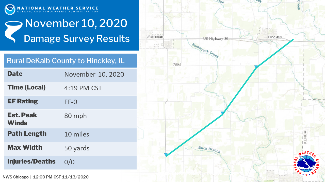
Tornado #1: Hinckley, IL EF-0
|
|
Summary: Based on radar data, spotter reports, and input from emergency management officials, an EF-0 tornado with peak winds of 80 mph, path length of 10 miles, and max width of 50 yards touched down in rural DeKalb county northwest of Somonauk and continued northeast into farm fields. A grain silo was damaged and power lines were downed along the path of the tornado before it lifted near Hinckley. |
|
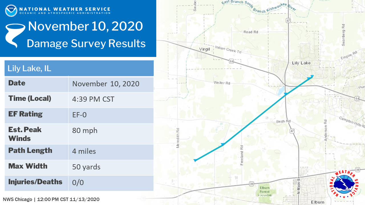
Tornado #2: Lily Lake, IL EF-0
|
|
Summary: Based on radar data and spotter reports, a brief EF-0 tornado with peak winds of 80 mph, path length of 4 miles, and max width of 50 yards touched down near Lily Lake and produced roof damage to an outbuilding and nearby trees. |
Strong Non-Thunderstorm Winds
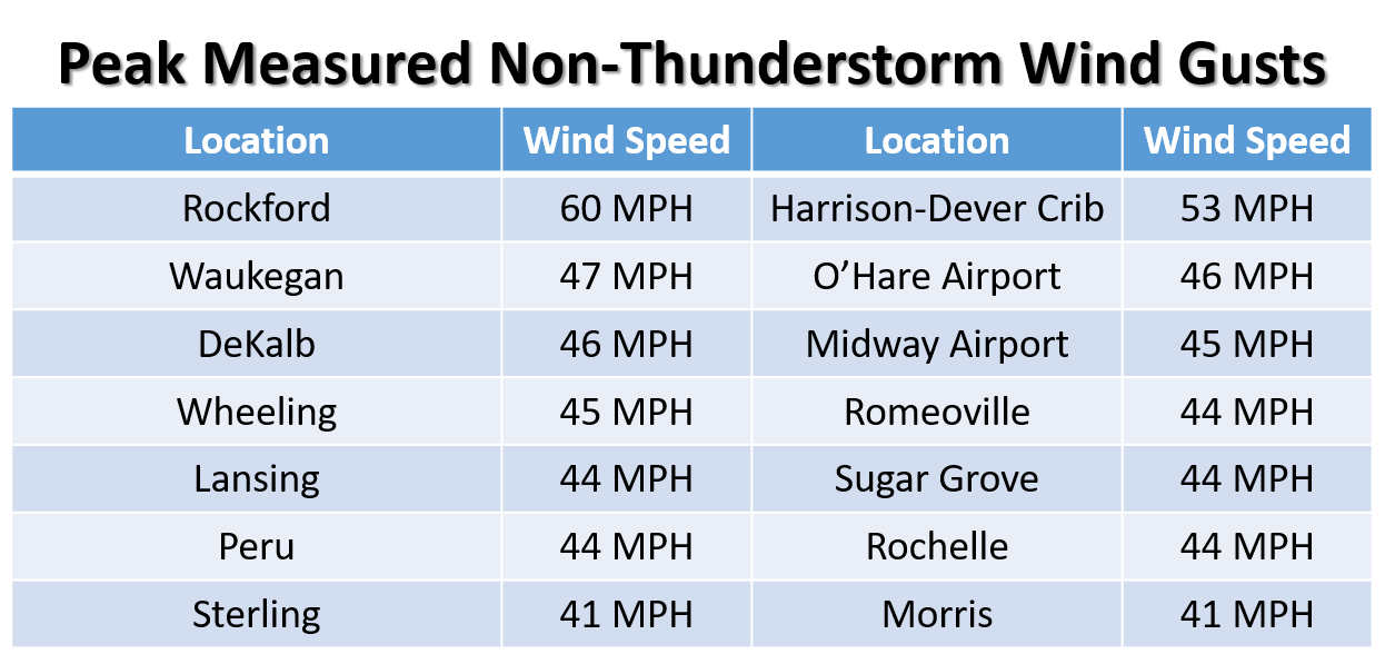 |
| Strongest measured non-thunderstorm wind gusts from a variety of sources |
Additional Info
 |
Media use of NWS Web News Stories is encouraged! Please acknowledge the NWS as the source of any news information accessed from this site. Additional recaps can be found on the NWS Chicago Past Events Page |
|