
Flash flooding threatens areas from the Tennessee Valley to the Carolinas as storms repeat along a stalled front. Monsoonal storms may trigger flooding in the Southwest. Dangerous heat expands across the Desert Southwest, Plains, mid-Mississippi Valley and Southern Tier. Critical fire weather for interior Pacific Northwest. Cooler, drier air brings brief relief to the Great Lakes and Northeast. Read More >
Overview
|
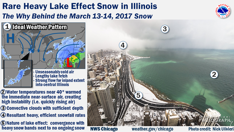
A quick-moving system on Sunday night, March 12 into early Monday, March 13, brought widespread snow, before lake effect snow started Monday night and persisted through Tuesday, March 14. This lake effect snow was oriented into northeast Illinois for a lengthy period, which is rare, as Michigan and northwest Indiana are typically the more favored locations for lake effect snow. The first round of snow caused impacts to the Monday morning commute, while the next lake effect round brought major impacts to the Tuesday morning commute.
For a satellite loop of the event, please visit the U. of Wisconsin CIMMS page. |
 |
Fast Facts
Snowfall Totals
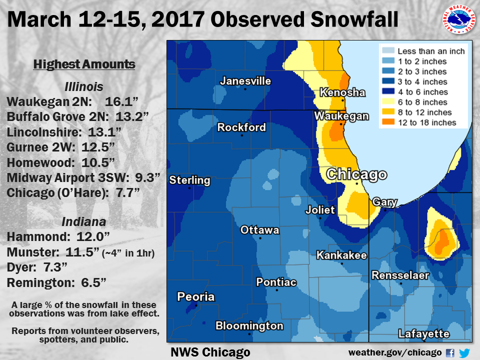 |
| Total Snowfall March 12-15 |
Public Information Statement
National Weather Service Chicago IL
554 PM CDT Wed Mar 15 2017 /654 PM EDT Wed Mar 15 2017/

...3-DAY SNOWFALL ROUND-UP...

THE FOLLOWING ARE SNOW AMOUNTS FOR THE PREVIOUS 3 DAYS
AS MEASURED IN THE MORNING BY NWS COOPERATIVE OBSERVERS
AND COCORAHS OBSERVERS. OBSERVATIONS ARE USUALLY TAKEN
AT 7 AM DAILY. THIS MEANS MELTING CAN OCCUR BETWEEN
OBSERVATIONS.

  3-DAY SNOW TOTALS THROUGH WEDNESDAY (03/15/17)
  AS OF 10:00 AM CDT

ILLINOIS                                 3-DAY SNOW FALL
  LOCATION (COUNTY):                         AMT(IN) REPORTS

  WAUKEGAN 2N (LAKE)...........................16.1
  BUFFALO GROVE 2N (LAKE)......................13.2
  LINCOLNSHIRE 1N (LAKE).......................13.1
  GURNEE 2W (LAKE).............................12.5
  MUNDELEIN 2WNW (LAKE)........................12.4
  BURNHAM-HEGEWISCH 2NNW (COOK)................10.5
  HOMEWOOD (COOK)..............................10.5
  BOTANIC GARDENS (COOK).......................10.4
  HIGHWOOD 1S (LAKE)...........................10.2
  RIVERWOODS (LAKE)............................10.2
  MIDWAY 3SW COOP (COOK)........................9.3
  PARK RIDGE (COOK).............................9.2
  LINCOLNWOOD 2E (COOK).........................9.1
  MOUNT PROSPECT 3NE (COOK).....................9.0
  OAK PARK 1NNE (COOK)..........................8.8
  ROGERS PARK 2SW (COOK)........................8.7
  CHICAGO RIDGE (COOK)..........................8.6
  LAKE ZURICH (LAKE)............................8.1
  ELK GROVE VILLAGE 1ESE (COOK).................8.1
  BRIDGEVIEW 1NNW (COOK)........................8.0
  OAK LAWN (COOK)...............................8.0
  ALSIP (COOK)..................................7.5
  SCHAUMBURG 2E (COOK)..........................7.3
  ELK GROVE VILLAGE 2WSW (COOK).................7.2
  ELMHURST 1ESE (DU PAGE).......................7.0
  PARK RIDGE 1WNW (COOK)........................7.0
  WORTH (COOK)..................................6.8
  MOKENA 1W (WILL)..............................6.0
  ELMHURST 2SE (DU PAGE)........................5.9
  WILLOW SPRINGS (COOK).........................5.8
  HARVARD (MCHENRY).............................5.5
  LA GRANGE PARK 1SSW (COOK)....................5.4
  BULL VALLEY 2WNW (MCHENRY)....................5.3
  NEW LENOX 3E (WILL)...........................5.3
  WONDER LAKE 1WNW (MCHENRY)....................5.3
  MACHESNEY PARK 3ENE (WINNEBAGO)...............5.0
  PEOTONE (WILL)................................4.6
  CRETE 3E (WILL)...............................4.5
  MANHATTAN 5ENE (WILL).........................4.5
  ROCKFORD 2ENE (WINNEBAGO).....................4.5
  STERLING 4NE (LEE)............................4.5
  AURORA 4NE (DUPAGE)...........................4.4
  NAPERVILLE 1NW (DU PAGE)......................4.4
  MONEE (WILL)..................................4.2
  ROCKFORD 1NW (WINNEBAGO)......................4.2
  ROMEOVILLE (WILL).............................4.1
  ST. CHARLES (KANE)............................4.1
  BURR RIDGE 2SW (DU PAGE)......................4.1
  ROSCOE 2SE (WINNEBAGO)........................4.0
  MCHENRY (MCHENRY).............................4.0
  ROSCOE 2ESE (WINNEBAGO).......................4.0
  DIXON 3NNW (LEE)..............................4.0
  AMBOY (LEE)...................................4.0


INDIANA                                    3-DAY SNOW FALL
  LOCATION (COUNTY):                         AMT(IN) REPORTS

  DYER 1WNW (LAKE)..............................7.3
  REMINGTON (JASPER)............................6.5
  (KB9F)VALPARAISO 4S (PORTER)..................5.0
  (W9OPR)WHEATFIELD 1ENE (JASPER)...............5.0
  HEBRON 4NE (PORTER)...........................4.6
  CHESTERTON 4E (PORTER)........................4.5
  GARY 5ENE (LAKE)..............................3.7
  PORTAGE 1ESE (PORTER).........................3.7
  DE MOTTE 1NNW (JASPER)........................3.7

$$

MTF
First Event
 |
|
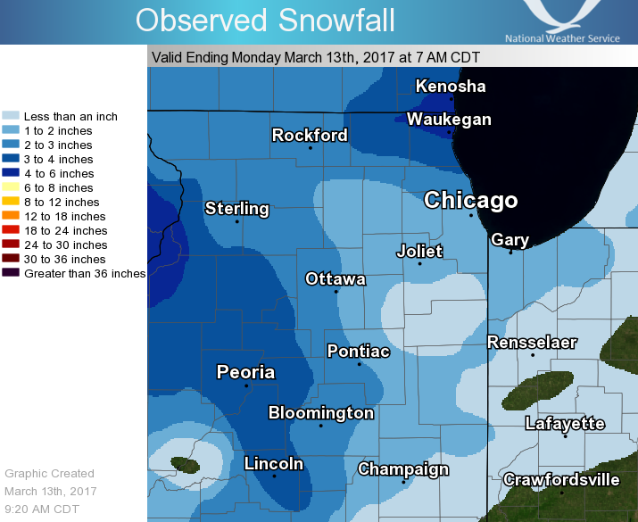
| Snowfall Through Early Morning on March 13th |
Public Information Statement
National Weather Service Chicago IL
0930 AM CDT Mon Mar 13 2017

...Morning Snowfall Roundup...

   The following are snow amounts for the previous 24 hours
   as measured in the morning by NWS Cooperative Observers
   and CoCoRaHS observers.
   Observations are usually taken at 7 AM.

   24-hour Snowfall Amounts for Monday(03/13/17)...


Northern Illinois                              Snow
  Location (County):                           fall(inches)

  Waukegan 2N (Lake)............................5.5
  Bull Valley 2WNW (McHenry)....................4.8
  Wonder Lake 1WNW (McHenry)....................4.7
  Hebron (McHenry)..............................4.5
  Harvard (McHenry).............................4.5
  Gurnee 2W (Lake)..............................4.5
  Lincolnshire 1N (Lake)........................4.0
  Buffalo Grove 2N (Lake).......................4.0
  Mundelein (Lake)..............................4.0
  Highwood 1S (Lake)............................3.9
  Botanic Gardens (Cook)........................3.8
  Lake Zurich (Lake)............................3.6
  Riverwoods (Lake).............................3.5
  Mundelein 2WNW (Lake).........................3.5
  La Salle (La Salle)...........................3.5
  Belvidere (Boone).............................3.2
  Marengo (McHenry).............................3.2
  Lincolnwood 2E (Cook).........................3.1
  Chatsworth (Livingston).......................3.0
  Mount Prospect 3NE (Cook).....................3.0
  Dixon 3NNW (Lee)..............................3.0
  Cary (McHenry)................................3.0
  Ashton (Lee)..................................2.9
  Barrington (Lake).............................2.8
  Park Ridge (Cook).............................2.8
  Polo (Ogle)...................................2.8
  Ottawa 2N (La Salle)..........................2.7
  Streator 1WSW (La Salle)......................2.7
  Byron 3N (Ogle)...............................2.7
  Ottawa (La Salle).............................2.7
  Elk Grove Village 1ESE (Cook).................2.5
  Elmhurst 1ESE (Du Page).......................2.5
  Dixon 2SW (Lee)...............................2.5
  Rockford 1NW (Winnebago)......................2.5
  Capron (Boone)................................2.4
  Schaumburg 2E (Cook)..........................2.4
  Elgin 2W (Kane)...............................2.4
  Roscoe 2ESE (Winnebago).......................2.4
  Paw Paw (Lee).................................2.4
  Roscoe 2se (Winnebago)........................2.4
  Elmhurst 2SE (Du Page)........................2.3
  Downers Grove 0.4NNE (Du Page)................2.3
  Geneva 1SSW (Kane)............................2.3
  Ohare (Cook)..................................2.2
  Genoa (De Kalb)...............................2.1
  La Grange Park 1SSW (Cook)....................2.1
  Rockford (Winnebago)..........................2.1
  Fairbury (Livingston).........................2.0
  Hoffman Estates 5W (Cook).....................2.0
  Chicago 6ESE (Cook)...........................2.0
  Oak Lawn (Cook)...............................2.0
  Ottawa 1NW (La Salle).........................2.0
  Steward (Lee).................................2.0
  Lisle Morton Arb (Du Page)....................2.0
  Park Ridge 1WNW (Cook)........................1.9
  Elgin (Kane)..................................1.8
  Batavia 2WNW (Kane)...........................1.8
  North Aurora 2NE (Kane).......................1.8
  Willow Springs (Cook).........................1.8
  Yorkville 2SE (Kendall).......................1.8
  Alsip (Cook)..................................1.7
  Elk Grove Village 2WSW (Cook).................1.7
  Batavia 1WNW (Kane)...........................1.7
  Mendota (La Salle)............................1.7
  Rochelle (Ogle)...............................1.7
  De Kalb (De Kalb).............................1.6
  Crete 3E (Will)...............................1.6
  Midway Coop (Cook)............................1.6
  Chicago Ridge (Cook)..........................1.5
  Homewood (Cook)...............................1.5
  Aurora 4SE (Du Page)..........................1.5
  Burr Ridge 2SW (Du Page)......................1.5
  Oswego 5SSE (Kendall).........................1.5
  Plainfield 5SW (Kendall)......................1.5
  Streator 4ENE (La Salle)......................1.5
  New Lenox 2SE (Will)..........................1.5
  Lockport 1SE (Will)...........................1.5
  Westmont (Du Page)............................1.5
  Bourbonnais (Kankakee)........................1.4
  Sugar Grove 1NE (Kane)........................1.4
  Batavia 1WSW (Kane)...........................1.4
  Manhattan (Will)..............................1.4
  Batavia (Kane)................................1.3
  Worth (Cook)..................................1.3
  Downers Grove 0.4NNE (Du Page)................1.3
  Mokena 1W (Will)..............................1.3
  Homer Glen 1ENE (Will)........................1.2
  Romeoville (Will).............................1.2
  Ashkum 5.6E (Iroquois)........................1.1
  Joliet 2n (Will)..............................1.1
  Plainfield (Will).............................1.1
  Aurora (Kane).................................1.0
  Coal City 4NNW (Grundy).......................1.0
  Dwight (Livingston)...........................1.0
  Oak Park 2S (Cook)............................1.0
  Burnham-hegewisch 2NNW (Cook).................1.0
  Cortland (De Kalb)............................1.0
  Somonauk 2NE (De Kalb)........................1.0
  Carbon Hill 3.1N (Grundy).....................1.0
  Minooka (Grundy)..............................1.0
  Watseka 6.9WNW (Iroquois).....................1.0
  St. Charles 6NW (Kane)........................1.0
  Naperville 4SSW (Will)........................1.0
  New Lenox 4SE (Will)..........................1.0
  New Lenox 3E (Will)...........................1.0
  Joliet Lock/dam (Will)........................1.0
  Marseilles (La Salle).........................1.0
  Park Forest (Cook)............................1.0
  St Anne (Kankakee)............................1.0
  Morris 6ESE (Grundy)..........................0.8
  Rockford 3NE (Winnebago)......................0.8
  Palos Park 1SW (Cook).........................0.6
  Countryside 1ENE (Cook).......................0.5
  Bonfield 4WSW (Kankakee)......................0.5
  Peotone (Will)................................0.5
  Manhattan 2SE (Will)..........................0.3

Northwest Indiana                              Snow
  Location (County):                           fall(inches)

  Gary 5ENE (Lake)..............................2.5
  Portage 1ESE (Porter).........................2.5
  Lakes Of The Four Seasons 2NNE (Porter).......2.2
  (w9mal)Merrillville 2NNW (Lake)...............1.8
  Valparaiso 1NNW (Porter)......................1.6
  Crown Point 2WSW (Lake).......................1.5
  Valparaiso 6WSW (Porter)......................1.5
  Morocco (Newton)..............................1.5
  Crown Point 1N (Lake).........................1.4
  Hebron 4NE (Porter)...........................1.4
  De Motte 4SW (Jasper).........................1.0
  Valparaiso 6SSW (Porter)......................1.0
  Dyer 1WNW (Lake)..............................0.9
  Wheatfield 3S (Jasper)........................0.7
  De Motte 1NNW (Jasper)........................0.7
  Valparaiso 4SW (Porter).......................0.7
  (w9opr)Wheatfield 1ENE (Jasper)...............0.5
  (kb9f)Valparaiso 4S (Porter)..................0.5
  Rensselaer (Jasper)...........................0.5
  Rensselaer 2SSW (Jasper)....................TRACE
  Remington (Jasper)..........................TRACE

$$
Storm Reports
PRELIMINARY LOCAL STORM REPORT...SUMMARY
NATIONAL WEATHER SERVICE CHICAGO/ROMEOVILLE IL
835 PM CDT TUE MAR 14 2017

..TIME...   ...EVENT...      ...CITY LOCATION...     ...LAT.LON...
..DATE...   ....MAG....      ..COUNTY LOCATION..ST.. ...SOURCE....
            ..REMARKS..

0700 PM     SNOW             ROMEOVILLE              41.65N 88.09W
03/14/2017  M2.6 INCH        WILL               IL   OFFICIAL NWS OBS

            LAKE EFFECT SNOW TOTAL FROM MONDAY EVENING THROUGH
            TUESDAY MORNING AT NWS CHICAGO. STORM TOTAL SINCE SUNDAY
            NIGHT OF 4.1 INCHES.

0700 PM     SNOW             OHARE AIRPORT           41.98N 87.90W
03/14/2017  M7.7 INCH        COOK               IL   OFFICIAL NWS OBS

            STORM TOTAL SINCE SUNDAY NIGHT. LAKE EFFECT SNOW TOTAL OF
            5.2 INCHES SINCE MONDAY EVENING.

0700 PM     SNOW             OHARE AIRPORT           41.98N 87.90W
03/14/2017  M5.2 INCH        COOK               IL   OFFICIAL NWS OBS

            LAKE EFFECT SNOW TOTAL SINCE MONDAY EVENING. STORM TOTAL
            OF 7.7 INCHES SINCE SUNDAY NIGHT.

0700 PM     SNOW             ROMEOVILLE              41.65N 88.09W
03/14/2017  M4.1 INCH        WILL               IL   OFFICIAL NWS OBS

            STORM TOTAL SINCE SUNDAY NIGHT AT NWS CHICAGO. LAKE
            EFFECT SNOW TOTAL OF 2.6 INCHES.

0640 PM     SNOW             DYER                    41.50N 87.51W
03/14/2017  E10.0 INCH       LAKE               IN   PUBLIC

            ESTIMATED LAKE EFFECT SNOW TOTAL RELAYED VIA TWITTER AS
            OF 1230PM...WITH MINIMAL ACCUMULATION SINCE. ESTIMATED 2
            INCHES OVERNIGHT AND 8 INCHES BETWEEN 645AM AND 1230PM.

0600 PM     SNOW             2 NNW MUNSTER           41.57N 87.52W
03/14/2017  M10.0 INCH       LAKE               IN   COCORAHS

            LAKE EFFECT SNOW TOTAL.

0543 PM     SNOW             HAMMOND                 41.62N 87.49W
03/14/2017  E12.0 INCH       LAKE               IN   PUBLIC

            ESTIMATED LAKE EFFECT SNOW TOTAL RELAYED VIA FACEBOOK.

0539 PM     SNOW             ALSIP                   41.67N 87.74W
03/14/2017  E10.0 INCH       COOK               IL   PUBLIC

            ESTIMATED TOTAL RELAYED VIA FACEBOOK...MOST OF WHICH WAS
            LAKE EFFECT.

0530 PM     SNOW             5 SSE EVANSTON          41.99N 87.66W
03/14/2017  E7.0 INCH        COOK               IL   PUBLIC

            ESTIMATED LAKE EFFECT SNOW TOTAL SINCE MONDAY EVENING IN
            EDGEWATER NEIGHBORHOOD OF CHICAGO...MOST OF WHICH FELL ON
            TUESDAY MARCH 14TH. ESTIMATED STORM TOTAL SINCE SUNDAY
            NIGHT IS 9 INCHES.

0530 PM     SNOW             5 SSE EVANSTON          41.98N 87.66W
03/14/2017  M9.0 INCH        COOK               IL   PUBLIC

            ESTIMATED STORM TOTAL SINCE SUNDAY NIGHT IN EDGEWATER
            NEIGHBORHOOD OF CHICAGO. ESTIMATED LAKE EFFECT TOTAL IS 7
            INCHES...MOST OF WHICH FELL ON TUESDAY MARCH 14TH.

0530 PM     SNOW             1 SSW OAK LAWN          41.70N 87.76W
03/14/2017  M8.0 INCH        COOK               IL   COCORAHS

            STORM TOTAL SINCE SUNDAY NIGHT. LAKE EFFECT SNOW TOTAL 6
            INCHES.

0530 PM     SNOW             1 SSW OAK LAWN          41.70N 87.76W
03/14/2017  M6.0 INCH        COOK               IL   COCORAHS

            LAKE EFFECT SNOW TOTAL. 8 INCHES STORM TOTAL SINCE SUNDAY
            NIGHT.

0519 PM     SNOW             3 SW MIDWAY AIRPORT     41.75N 87.79W
03/14/2017  M9.3 INCH        COOK               IL   CO-OP OBSERVER

            STORM TOTAL SINCE SUNDAY NIGHT. 2 INCHES FROM SUNDAY
            NIGHT THROUGH MONDAY MORNING. 7.3 INCHES OF LAKE EFFECT
            SNOW FROM MONDAY EVENING THROUGH TUESDAY AFTERNOON.

0519 PM     SNOW             MUNSTER                 41.55N 87.50W
03/14/2017  E10.5 INCH       LAKE               IN   PUBLIC

            ESTIMATED LAKE EFFECT SNOW TOTAL AS OF 1230PM TUESDAY
            RELAYED VIA TWITTER. ESTIMATED 11.5 INCHES STORM TOTAL
            SINCE SUNDAY NIGHT.

0519 PM     SNOW             3 SW MIDWAY AIRPORT     41.75N 87.79W
03/14/2017  M7.3 INCH        COOK               IL   CO-OP OBSERVER

            LAKE EFFECT SNOW TOTAL SINCE MONDAY EVENING. 6.3 INCHES
            FELL ON MARCH 14TH. 1 INCH FELL IN 30 MINUTES BETWEEN 240
            PM AND 310 PM CDT ON TUESDAY MARCH 14TH.

0514 PM     SNOW             HOMEWOOD                41.56N 87.66W
03/14/2017  E10.0 INCH       COOK               IL   PUBLIC

            ESTIMATE OF AT LEAST 10 INCHES TOTAL RELAYED VIA
            FACEBOOK...MOST OF WHICH WAS LAKE EFFECT.

1100 AM     HEAVY SNOW       1 NNW MUNSTER           41.56N 87.51W
03/14/2017  E4.4 INCH        LAKE               IN   COCORAHS

            SNOW FELL IN ONE HOUR. 9.5 INCHES OF SNOW ON GROUND.

1056 AM     SNOW             LINCOLN PARK            41.93N 87.64W
03/14/2017  M6.5 INCH        COOK               IL   PUBLIC

1000 AM     SNOW             2 NNW MUNSTER           41.57N 87.52W
03/14/2017  M2.6 INCH        LAKE               IN   COCORAHS

            SNOW IN THE PAST 2 HOURS. TOTAL SNOW ON GROUND 5.1
            INCHES.


&&

$$

RC
Lake Effect Snow Winds
Public Information Statement
National Weather Service Chicago IL
1218 AM CDT Wed Mar 15 2017 /118 AM EDT Wed Mar 15 2017/

...Highest Wind Observations With Lake Effect Snow...

Location                     Speed     Time/Date       Provider
---------------------------------------------------------------
Michigan City C-man          46 MPH    0700 PM 03/14   MARITIME
Burns Harbor                 42 MPH    1000 PM 03/14   NWS-GLOS
1 SE Lake Bluff              41 MPH    0821 AM 03/13   CWOP
Gary Airport                 40 MPH    0645 PM 03/14   AWOS
Chicago Crib                 40 MPH    0430 PM 03/14   MARITIME
Chicago Midway               36 MPH    0806 AM 03/14   ASOS
1 WNW New Chicago            36 MPH    0510 PM 03/14   INDOT
2 W Collegeville             34 MPH    0400 PM 03/14   INDOT
Porter                       31 MPH    0717 PM 03/14   RAWS
Valparaiso Airport           30 MPH    0833 PM 03/14   ASOS
Chicago O`Hare               29 MPH    0351 PM 03/14   ASOS
Additional
Links
 |
Media use of NWS Web News Stories is encouraged! Additional recaps can be found on the NWS Chicago Past Events Page. |
|

