Chicago, IL
Weather Forecast Office
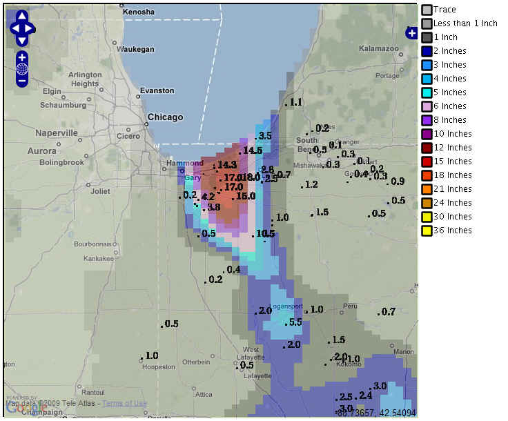
Snowfall recorded for the 24 hour period ending between 6 and 8 am on Wednesday, February 4, is shown above. A table of values is below:
Area snowfall reports
|
Location
|
Amount
|
|
VALPARAISO 0.4 SSW, IN
|
19
|
|
VALPARAISO 1.4 ENE, IN
|
17
|
|
VALPARAISO 5 NNE
|
17
|
|
VALPARAISO 1.8 NW, IN
|
16.2
|
|
VALPARAISO 2.4 SW, IN
|
15.1
|
|
KOUTS 2.8 N, IN
|
15
|
|
PORTER 0.6 S, IN
|
14.3
|
|
VALPARAISO 2.8 WSW, IN
|
14
|
|
VALPARAISO 5.1 WSW, IN
|
12
|
|
MICHIGAN CITY 7 SW
|
10
|
|
PORTAGE 0.9 ESE, IN
|
8
|
|
HEBRON 3.7 NE, IN
|
3.8
|
|
CROWN POINT 7.6 ESE, IN
|
2
|
|
CROWN POINT 6.6 ESE, IN
|
1.5
|
|
CHALMERS 5 W
|
0.5
|
|
DE MOTTE 0.8 NNW, IN
|
0.5
|
|
RENSSELAER 8.4 ENE, IN
|
0.4
|
|
CROWN POINT 1.1 N, IN
|
0.2
|
Hazards
Enhanced Hazardous Weather Outlook
Hazardous Weather Outlook
National Briefing
Storm Spotter Training and Seminars
Outlooks
Watch/Warning/Advisory Criteria
Snow Squall Warnings
Local Forecasts
Marine
Aviation
Fire
Text Products
Great Lakes Marine Portal
Lake Michigan Beach Forecast
El Nino
Snow and Ice Probabilities
US Dept of Commerce
National Oceanic and Atmospheric Administration
National Weather Service
Chicago, IL
250 George J Michas Dr.
Romeoville, IL 60446
815-834-1435 8am-8pm
Comments? Questions? Please Contact Us.

