Facts | Snowfall | Meteorology | Service
Chicago:
Rockford:
PUBLIC INFORMATION STATEMENT
NATIONAL WEATHER SERVICE CHICAGO IL
1025 AM CST WED MAR 06 2013
...MORNING SNOWFALL ROUNDUP...
SNOWFALL REPORTS ARE FROM
THE FOLLOWING ARE SNOW AMOUNTS FOR THE PREVIOUS 24-HOURS.
THESE REPRTS ARE PROVIDED BY NATIONAL WEATHER SERVICE CHICAGO
COOP AND COCORAHS OBSERVERS AS WELL AS THE CHICAGO AREA AND
ROCKFORD AREA SNOWFALL TEAM.
OBSERVATIONS ARE USUALLY TAKEN AT 7 AM.
24-HOUR SNOWFALL AMOUNTS FOR WEDNESDAY(03/06/13)...
NORTHERN ILLINOIS SNOW
LOCATION (COUNTY): FALL(INCHES)
HOMER GLEN 1ENE (WILL).......................11.8
YORKVILLE 2SE (KENDALL)......................11.7
ORLAND PARK 5WNW (WILL)......................11.3
DE KALB (DE KALB)............................10.2
ELGIN 1WSW (KANE)............................10.1
ELGIN 2W (KANE)..............................10.1
ELBURN (KANE)................................10.0
ORLAND HILLS 1SE (COOK)......................10.0
PALOS PARK 1SW (COOK)........................10.0
MONTGOMERY 2SSE (KENDALL)....................10.0
LILY LAKE 2E (KANE)..........................10.0
NORTH RIVERSIDE (COOK)........................9.9
WILLOW SPRINGS (COOK).........................9.9
LA GRANGE PARK 1SSW (COOK)....................9.8
WESTMONT 1SSE (DU PAGE).......................9.8
WILLOWBROOK (COOK)............................9.7
BURR RIDGE 2SW (DU PAGE)......................9.7
MIDWAY COOP (COOK)............................9.6
DOWNERS GROVE (COOK)..........................9.3
SOUTH WILMINGTON 2E (GRUNDY)..................9.3
ST. CHARLES (KANE)............................9.3
ST. CHARLES 6NW (KANE)........................9.3
OAK BROOK (DU PAGE)...........................9.2
OHARE (COOK)..................................9.2
GENOA (DE KALB)...............................9.1
OAK PARK 1SW (COOK)...........................9.1
DE KALB (DE KALB).............................9.1
HOFFMAN ESTATES 5W (COOK).....................9.0
COUNTRYSIDE 1ENE (COOK).......................9.0
AURORA 4SE (DU PAGE)..........................9.0
YORKVILLE 1NE (KENDALL).......................9.0
OTTAWA (LA SALLE).............................9.0
NEW LENOX 2SE (WILL)..........................9.0
ROCKFORD 3NE (WINNEBAGO)......................9.0
LANSING (COOK)................................9.0
ROCKFORD (WINNEBAGO)..........................9.0
SCHAUMBURG 2E (COOK).........................8.9
BRACEVILLE (GRUNDY)...........................8.8
BEECHER (WILL)................................8.8
MOKENA 1W (WILL)..............................8.7
ROMEOVILLE (WILL).............................8.7
PALATINE 1E (COOK)............................8.6
HOMER GLEN 4WNW (WILL)........................8.6
OAK PARK 2S (COOK)............................8.5
ALSIP (COOK)..................................8.5
HOMEWOOD (COOK)...............................8.5
OAK PARK 1NNE (COOK)..........................8.5
LISLE (DU PAGE)...............................8.5
NAPERVILLE 1NW (DU PAGE)......................8.5
MARSEILLES 6WNW (LA SALLE)....................8.5
JOLIET (WILL).................................8.5
PAW PAW (LEE).................................8.5
WOODSTOCK 5NW (MCHENRY).......................8.5
CHANNAHON (WILL)..............................8.4
JOLIET 2N (WILL)..............................8.4
ELK GROVE VILLAGE 1ESE (COOK).................8.3
ELMHURST 1ESE (DU PAGE).......................8.3
NORTH AURORA 2NE (KANE).......................8.3
GENEVA 1SSW (KANE)............................8.3
JOLIET LOCK/DAM (WILL)........................8.3
EVANSTON 1N (COOK)............................8.2
PLAINFIELD (WILL).............................8.2
ST CHARLES 7NW (KANE).........................8.2
BOLINGBROOK 3NE (DU PAGE).....................8.1
CAPRON (BOONE)................................8.0
WORTH (COOK)..................................8.0
ORLAND HILLS 1S (COOK)........................8.0
GLEN ELLYN 2SSE (DU PAGE).....................8.0
ALGONQUIN 1N (MCHENRY)........................8.0
WILMINGTON 3SE (WILL).........................8.0
LOCKPORT 1SE (WILL)...........................8.0
WILMINGTON 6NW (WILL).........................8.0
MACHESNEY PARK 3ENE (WINNEBAGO)...............8.0
ROCHELLE (OGLE)...............................8.0
LISLE MORTON ARB (DU PAGE)....................8.0
LOMBARD 1NNW (DU PAGE)........................7.9
BURNHAM-HEGEWISCH 2NNW (COOK).................7.8
BATAVIA 2WNW (KANE)...........................7.8
BATAVIA 1WNW (KANE)...........................7.8
CRETE 3E (WILL)...............................7.8
PEOTONE (WILL)................................7.8
NEW LENOX 3E (WILL)...........................7.8
ROSCOE 2ESE (WINNEBAGO).......................7.8
PEOTONE (WILL)................................7.8
ROCKFORD 4NW (WINNEBAGO)......................7.8
ROSCOE 2SE (WINNEBAGO)........................7.8
WINFIELD (DU PAGE)............................7.8
BATAVIA (KANE)................................7.7
PEOTONE (WILL)................................7.7
SCHAUMBURG 3WSW (COOK)........................7.6
BUFFALO GROVE 2N (LAKE).......................7.6
CHICAGO RIDGE (COOK)..........................7.5
PARK RIDGE (COOK).............................7.5
ELK GROVE VILLAGE 2WSW (COOK).................7.5
SUGAR GROVE 1NE (KANE)........................7.5
GENEVA 2WSW (KANE)............................7.5
WOODSTOCK 2WSW (MCHENRY)......................7.5
ROCKFORD 1NW (WINNEBAGO)......................7.5
WOODSTOCK (MCHENRY)...........................7.5
LISLE 1SE (DU PAGE)...........................7.4
OTTAWA 2N (LA SALLE)..........................7.4
GLEN ELLYN (DU PAGE)..........................7.3
DOWNERS GROVE 2SE (DU PAGE)...................7.3
HEBRON (MCHENRY)..............................7.2
LINCOLNSHIRE 1.3WSW (LAKE)....................7.2
MANHATTAN 5ENE (WILL).........................7.2
PEOTONE (WILL)................................7.2
POLO (OGLE)...................................7.2
MCHENRY (MCHENRY).............................7.1
AURORA (KANE).................................7.0
CHICAGO 6ESE (COOK)...........................7.0
HARWOOD HEIGHTS 2NNE (COOK)...................7.0
CORTLAND (DE KALB)............................7.0
CARY (MCHENRY)................................7.0
OTTAWA (LA SALLE).............................7.0
COAL CITY 4NNW (GRUNDY).......................6.9
CARBON HILL 3.1N (GRUNDY).....................6.9
PONTIAC 1ESE (LIVINGSTON).....................6.9
ELGIN (KANE)..................................6.8
INVERNESS 2S (COOK)...........................6.8
YORKVILLE 1W (KENDALL)........................6.8
DIXON 3NNW (LEE)..............................6.8
PEOTONE (WILL)................................6.8
BOURBONNAIS (KANKAKEE)........................6.7
AURORA 4SE (DU PAGE)..........................6.7
ASHTON (LEE)..................................6.7
CARY 2NE (MCHENRY)............................6.7
MOMENCE (KANKAKEE)............................6.7
MUNDELEIN (LAKE)..............................6.6
EARLVILLE 3S (LA SALLE).......................6.5
LINCOLNWOOD 2E (COOK).........................6.5
CAROL STREAM (DU PAGE)........................6.5
BARTLETT 1SSE (DU PAGE).......................6.5
LAKE VILLA 1SSW (LAKE)........................6.5
LINCOLNSHIRE 1N (LAKE)........................6.5
SENECA 2SSW (LA SALLE)........................6.5
MENDOTA 2SE (LA SALLE)........................6.5
NEW LENOX 4SE (WILL)..........................6.5
LAKE ZURICH (LAKE)............................6.5
MARENGO (MCHENRY).............................6.5
ARLINGTON HEIGHTS 2NNW (COOK).................6.3
MANHATTAN 2SE (WILL)..........................6.3
GRAYSLAKE (LAKE)..............................6.2
GURNEE 2W (LAKE)..............................6.2
KANKAKEE (KANKAKEE)...........................6.2
MARSEILLES (LA SALLE).........................6.2
MORRIS (GRUNDY)...............................6.1
SPRING GROVE 2N (MCHENRY).....................6.1
HARVARD (MCHENRY).............................6.0
STREATOR 4ENE (LA SALLE)......................6.0
SENECA 1NE (LA SALLE).........................6.0
STREATOR 1WSW (LA SALLE)......................6.0
ROCKTON 1ESE (WINNEBAGO)......................6.0
PARK FOREST (COOK)............................6.0
AMBOY (LEE)...................................5.9
SUBLETTE (LEE)................................5.5
LAKEMOOR 2SE (LAKE)...........................5.5
ST ANNE (KANKAKEE)............................5.5
STEWARD (LEE).................................5.5
BOTANIC GARDENS (COOK)........................5.4
HIGHWOOD 1S (LAKE)............................5.4
MILFORD (IROQUOIS)............................5.4
DRESDEN LOCK/DAM (GRUNDY).....................5.3
ELGIN (KANE)..................................5.3
MORRIS 6ESE (GRUNDY)..........................5.3
ELGIN 1S (KANE)...............................5.3
DWIGHT (LIVINGSTON)...........................5.0
BOURBONNAIS 2NNE (KANKAKEE)...................5.0
DIXON 2SW (LEE)...............................5.0
WAUKEGAN 2N (LAKE)............................5.0
MARSEILLES 3NW (LA SALLE).....................5.0
MENDOTA (LA SALLE)............................5.0
STREATOR (LIVINGSTON).........................5.0
MAZON (GRUNDY)................................4.9
BEACH PARK 1W (LAKE)..........................4.8
LAKE BLUFF 1W (LAKE)..........................4.8
SHERIDAN (LA SALLE)...........................4.8
FOX LAKE 2SE (LAKE)...........................4.6
CHATSWORTH (LIVINGSTON).......................4.5
CHATSWORTH (LIVINGSTON).......................4.5
WATSEKA (IROQUOIS)............................4.2
FAIRBURY (LIVINGSTON).........................4.0
WATSEKA 5W (IROQUOIS).........................4.0
BONFIELD 4WSW (KANKAKEE)......................4.0
LA SALLE (LA SALLE)...........................4.0
OGLESBY 0.4N (LA SALLE).......................3.4
PAXTON (FORD).................................3.0
NORTHWEST INDIANA SNOW
LOCATION (COUNTY): FALL(INCHES)
VALPARAISO (PORTER)..........................10.5
PORTER 1S (PORTER)...........................10.4
(W9OPR)WHEATFIELD 1ENE (JASPER)..............10.0
LAKE VILLAGE (NEWTON).........................9.5
CROWN POINT (LAKE)............................9.0
ST. JOHN (LAKE)...............................9.0
PORTAGE 1ESE (PORTER).........................9.0
RENSSELAER (JASPER)...........................9.0
VALPARAISO 2N (PORTER)........................8.8
VALPARAISO 1NE (PORTER).......................8.7
VALPARAISO 1ENE (PORTER)......................8.5
VALPARAISO 5NNE (PORTER)......................8.2
VALPARAISO 5NNE (PORTER)......................8.2
WHEATFIELD 3S (JASPER)........................8.0
DE MOTTE 1NNW (JASPER)........................8.0
DE MOTTE 1SSW (JASPER)........................8.0
VALPARAISO 1NNW (PORTER)......................8.0
DYER 1WNW (LAKE)..............................7.8
HEBRON 4NE (PORTER)...........................7.7
SCHERERVILLE 2WSW (LAKE)......................7.6
LAKES OF THE FOUR SEASONS 2NNE (PORTER).......7.6
CROWN POINT 2WSW (LAKE).......................7.5
VALPARAISO 1SE (PORTER).......................7.5
CHESTERTON 1ENE (PORTER)......................7.2
LOWELL (LAKE).................................7.2
DE MOTTE 4SW (JASPER).........................7.0
(W9MAL)MERRILLVILLE 2NNW (LAKE)...............7.0
LAKES OF THE FOUR SEASONS (PORTER)............7.0
MOROCCO (NEWTON)..............................7.0
SCHERERVILLE (LAKE)...........................6.6
DE MOTTE 6S (JASPER)..........................6.5
CROWN POINT 1N (LAKE).........................6.5
HIGHLAND (LAKE)...............................6.3
MOUNT AYR 2NNE (NEWTON).......................6.2
(WV90)HOBART 1ENE (LAKE)......................6.0
REMINGTON (JASPER)............................5.8
VALPARAISO 4SW (PORTER).......................5.7
BROOK 4W (NEWTON).............................5.5
VALPARAISO 6WSW (PORTER)......................5.5
REMINGTON (JASPER)............................5.5
KENTLAND 1NNW (NEWTON)........................5.0
$$
|
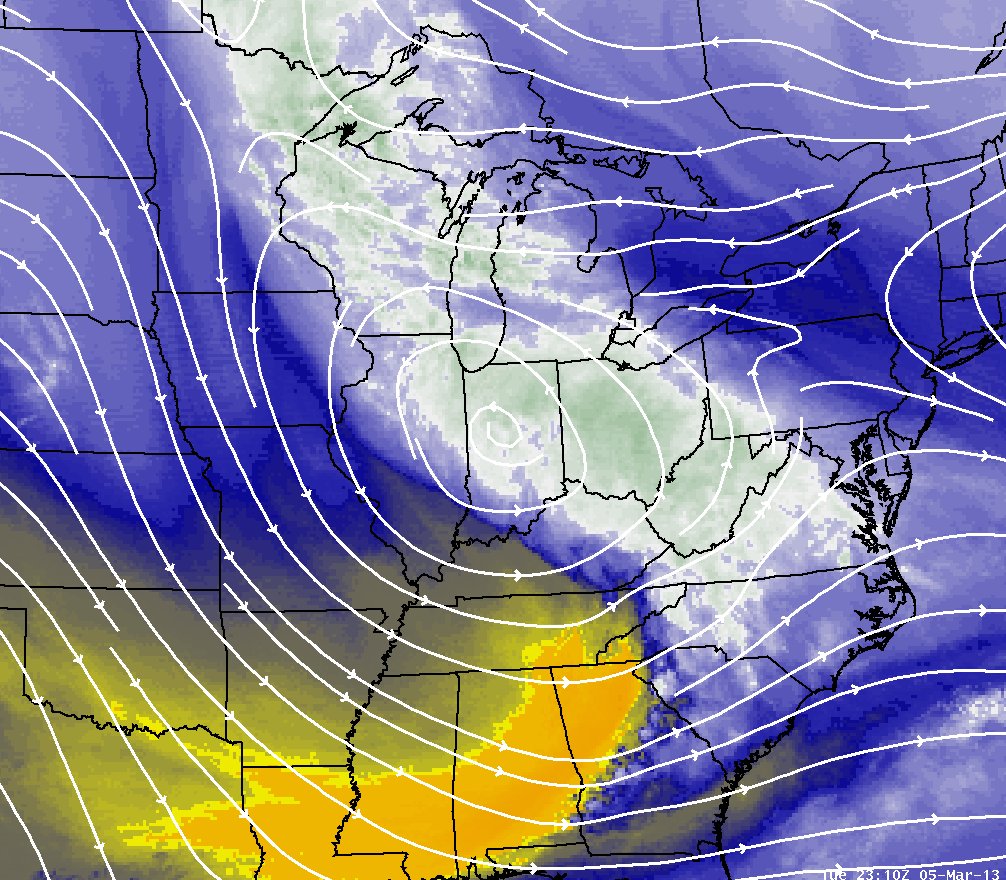
March 5, 2013: Late Afternoon Water Vapor Image with Upper Level Streamlines Overlaid |
|
|
|
Typically, systems from the northwest are not the largest snowfall producers for the Chicago area, as they can have limited amounts of moisture and at times produce snow for only a short duration. As this low pressure system approached the area from the northwest, it was in a strengthening pattern, meaning more support for lift and simply slower movement for longer duration snowfall. Also, this was bringing Pacific moisture from around the Rockies while tapping into Gulf of America moisture. The air mass was warm enough to hold high amounts of this moisture yet just cool enough for precipitation type to be only snow. The overlaid streamlines above are from a model analysis and are at around 10,000 ft. Note the winds are from the southeast from Ohio back over Chicago, and then wrapping around the low. This is one indicator of a trough of warm air aloft (TROWAL), a characteristic of well-defined mid-latitude weather systems. This feature aids in bringing deep moisture into an area of strong forcing and colder air in weather system, and hence can be partially responsible for heavy snowfall. Other observational and model data indicated the presence of a TROWAL and helped sustain heavy snowfall rates late in the afternoon and early in the evening on the 5th. |
Below are observations from both Chicago and Rockford revealing the impressive duration of heavy snowfall rates.
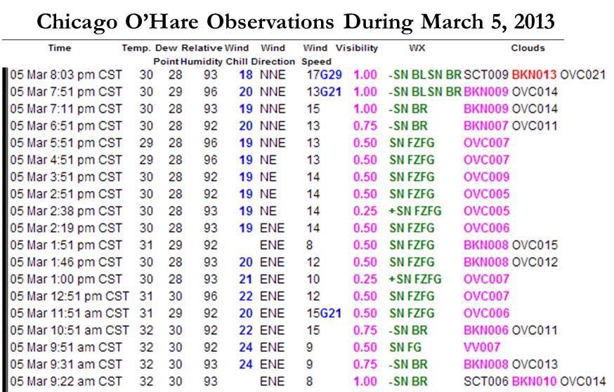
9:30 am until 7:11pm with visibility under 1 mile! Between 12pm and 6pm, 5.5" of snow fell.
5:36am until 5:29pm with visibility under 1 mile! 5.8" of snow fell from 6am to 12pm.
|
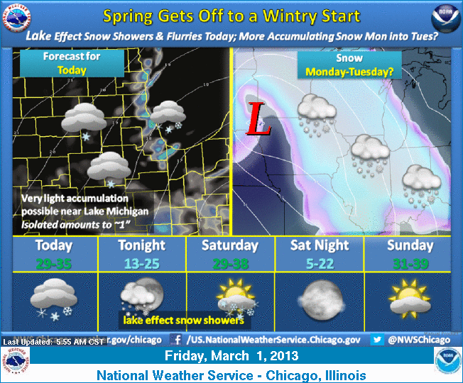
Weather Story Issued March 1st |
Weather Story Issued March 3rd |
|
|
 |
|
NWS Headlines |
||
|
|
 |
|
|
March 3rd P.M.: Watch Issued |
March 4th A.M.: Warning Issued for part of the area |
March 4th P.M.: Warning Issued for entire area. |