Overview
|
The period from August 12th-20th was a wet one across much of the region, with numerous rounds of thunderstorms with efficient rainfall rates. Of particular note were the following dates:
|
 August 7th-20th Rainfall |
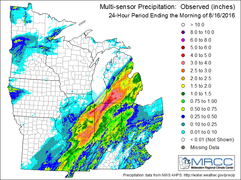
August 12:
|
|
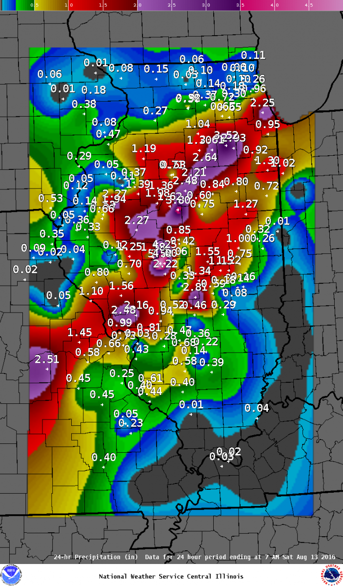 |
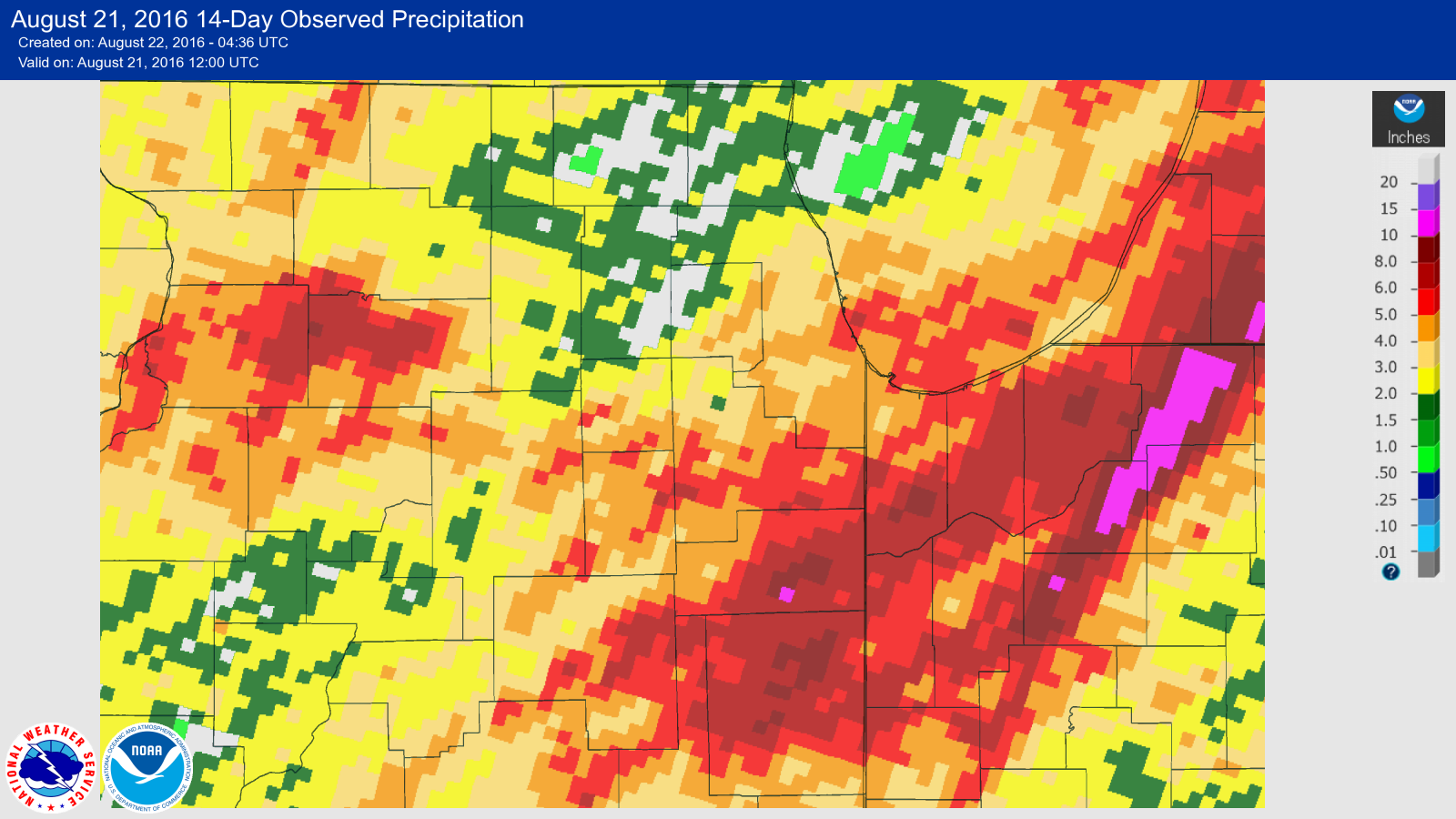
| Rainfall measurements/estimates across the Midwest from a variety of sources. | Rainfall from volunteer observers across Illinois. |
| Local Rainfall Reports from August 12th to early August 13th |
Public Information Statement
National Weather Service Chicago IL
1006 AM CDT Sat Aug 13 2016

...Morning Rainfall Roundup...

   The following are rain amounts for the previous 24-hours
   as measured in the morning by NWS Cooperative Observers
   and CoCoRaHS observers.
   Observations are usually taken between 6 AND 8 AM.

   24-hour rainfall amounts
       for Saturday(08/13/16)...


Illinois                                       Rain
  Location (County):                           fall (inches)

  Plainfield 5SW (Kendall).....................5.24
  Plainfield 2SSE (Will).......................4.83
  Joliet 2W (Will).............................4.75
  Plainfield 3SE (Will)........................4.40
  Morris 5NNW (Grundy).........................4.30
  Plainfield 1SW (Will)........................4.25
  Lisbon 4NE (Kendall).........................4.05
  Joliet 3WNW (Will)...........................3.94
  Channahon 1NNE (Will)........................3.69
  Joliet (Will)................................3.62
  Romeoville (Will)............................3.57
  Joliet 2n (Will).............................3.56
  Plainfield 3ESE (Will).......................3.54
  Morris (Grundy)..............................3.52
  Minooka (Grundy).............................3.51
  Wilmington 4WNW (Will).......................3.36
  Channahon 2SSE (Will)........................3.35
  Chicago 6ESE (Cook)..........................3.29
  Yorkville 2SE (Kendall)......................3.26
  Darien (Du Page).............................3.17
  Wilmington 6NW (Will)........................3.15
  Lockport 1SE (Will)..........................3.13
  Seneca 1NNE (La Salle).......................3.12
  Lisle (Du Page)..............................3.07
  Aurora 4SE (Du Page).........................3.04
  New Lenox 2SE (Will).........................2.97
  Coal City 4NNW (Grundy)......................2.93
  Carbon Hill 3.1N (Grundy)....................2.93
  Morris 2SSE (Grundy).........................2.91
  Countryside 1ENE (Cook)......................2.89
  Lisle 1SE (Du Page)..........................2.86
  Burr Ridge 2SW (Du Page).....................2.81
  Glen Ellyn 2SSE (Du Page)....................2.80
  Streator 1WSW (La Salle).....................2.74
  Oak Lawn (Cook)..............................2.72
  Naperville 2ESE (Du Page)....................2.72
  Ottawa 2N (La Salle).........................2.70
  Chicago Ridge (Cook).........................2.67
  Oak Lawn 2SE (Cook)..........................2.66
  Worth (Cook).................................2.66
  Sheridan 3SSE (La Salle).....................2.64
  Streator (Livingston)........................2.64
  Naperville 4SSW (Will).......................2.63
  Aurora 4SE (Du Page).........................2.62
  Naperville 1NW (Du Page).....................2.62
  Downers Grove 0.4NNE (Du Page)...............2.61
  Marseilles (La Salle)........................2.61
  Oak Lawn 2WNW (Cook).........................2.54
  Seneca 2SSW (La Salle).......................2.53
  Homer Glen 1ENE (Will).......................2.46
  Marseilles 5WNW (La Salle)...................2.45
  Downers Grove 1S (Du Page)...................2.43
  Palos Park 1SW (Cook)........................2.38
  Bolingbrook 3NE (Du Page)....................2.31
  La Grange Park 1SSW (Cook)...................2.30
  Elmhurst 2SE (Du Page).......................2.25
  Midway (Cook)................................2.25
  Beecher 3ENE (Will)..........................2.20
  Alsip (Cook).................................2.14
  Midway Coop (Cook)...........................2.14
  Chicago 5NE (Cook)...........................2.13
  Oswego 5SSE (Kendall)........................2.12
  New Lenox 3E (Will)..........................2.06
  Ottawa 1NW (La Salle)........................2.03
  Bridgeview 1NNW (Cook).......................2.02
  Chicago 6NNE (Cook)..........................2.00
  Willow Springs (Cook)........................2.00
  Elwood 5NE (Will)............................1.95
  Manhattan 1ESE (Will)........................1.89
  Manhattan 2SE (Will).........................1.86
  Elmhurst (Du Page)...........................1.84
  Park Ridge (Cook)............................1.80
  Elmhurst 1ESE (Du Page)......................1.77
  Villa Park 1NW (Du Page).....................1.77
  Manhattan 5ENE (Will)........................1.73
  Manhattan (Will).............................1.72
  Wilmington 3SE (Will)........................1.68
  Oak Park 1NNE (Cook).........................1.63
  Ravenswood Manor (Cook)......................1.60
  Oak Park 1SW (Cook)..........................1.60
  Momence (Kankakee)...........................1.59
  Dwight 4NNW (Grundy).........................1.48
  Lombard 1NNW (Du Page).......................1.45
  Montgomery 1SSE (Kendall)....................1.45
  Momence 6SSW (Kankakee)......................1.44
  New Lenox 4SE (Will).........................1.42
  Oak Park 2S (Cook)...........................1.40
  Ashkum 5.6E (Iroquois).......................1.38
  Monee (Will).................................1.36
  Park Ridge 1WNW (Cook).......................1.34
  Crete 3E (Will)..............................1.32
  Peotone (Will)...............................1.30
  Ottawa (La Salle)............................1.30
  Peotone (Will)...............................1.30
  St Anne (Kankakee)...........................1.30
  Paxton (Ford)................................1.27
  Braceville (Grundy)..........................1.19
  Bonfield 4WSW (Kankakee).....................1.17
  Mendota (La Salle)...........................1.15
  Peru (La Salle)..............................1.09
  Lincolnwood 2E (Cook)........................1.08
  Joliet (Will)................................1.07
  Bonfield 4NNE (Kankakee).....................1.05
  Earlville 3S (La Salle)......................1.04
  Park Forest 1NNE (Cook)......................1.03
  Flossmoor (Cook).............................1.02
  Park Forest 1SW (Cook).......................1.02
  Chebanse (Kankakee)..........................1.02
  Buckley (Iroquois)...........................1.00
  Ohare (Cook).................................0.96
  Somonauk 2NE (De Kalb).......................0.95
  Park Forest (Cook)...........................0.95
  Lansing (Cook)...............................0.94
  Plano (Kendall)..............................0.93
  Bourbonnais (Kankakee).......................0.92
  Sublette (Lee)...............................0.89
  Gibson 6NE (Ford)............................0.86
  La Salle (La Salle)..........................0.86
  Mendota 2SE (La Salle).......................0.85
  Kankakee (Kankakee)..........................0.84
  Chatsworth (Livingston)......................0.80
  Elburn (Kane)................................0.76
  Elburn (Kane)................................0.72
  Milford (Iroquois)...........................0.72
  Aurora (Kane)................................0.65
  Streamwood 1W (Cook).........................0.63
  Pontiac (Livingston).........................0.63
  Cissna Park 1S (Iroquois)....................0.58
  Geneva 4WSW (Kane)...........................0.56
  Gibson 2SW (Ford)............................0.53
  Gibson 3WNW (Ford)...........................0.52
  Rochelle (Ogle)..............................0.52
  North Aurora 2NE (Kane)......................0.51
  Amboy (Lee)..................................0.51
  Geneva 1SSW (Kane)...........................0.49
  Batavia (Kane)...............................0.47
  Carol Stream (Du Page).......................0.47
  Batavia 2WNW (Kane)..........................0.47
  Steward (Lee)................................0.45
  Batavia 1WNW (Kane)..........................0.44
  Winfield (Du Page)...........................0.44
  Bartlett 1SE (Du Page).......................0.39
  De Kalb (De Kalb)............................0.37
  Winnetka 1ESE (Cook).........................0.35
  Lily Lake 2E (Kane)..........................0.33
  Arlington Heights 1SW (Cook).................0.32
  West Chicago (Du Page).......................0.30
  Rochelle (Ogle)..............................0.30
  Ashton (Lee).................................0.28
  Highwood 1S (Lake)...........................0.28
  De Kalb (De Kalb)............................0.27
  Schaumburg 2E (Cook).........................0.26
  Roselle 1ESE (Du Page).......................0.26
  Mundelein (Lake).............................0.26
  Bull Valley 2WNW (McHenry)...................0.26
  Wheeling (Cook)..............................0.26
  Glencoe (Cook)...............................0.25
  Bannockburn (Lake)...........................0.25
  St. Charles 6NW (Kane).......................0.24
  Dixon 2SW (Lee)..............................0.24
  Elgin (Kane).................................0.22
  Elk Grove Village 2WSW (Cook)................0.22
  Elgin 1S (Kane)..............................0.22
  Hoffman Estates 5W (Cook)....................0.20
  Dixon 3NNW (Lee).............................0.19
  Elgin (Kane).................................0.18
  Elgin 2W (Kane)..............................0.18
  Libertyville 2ESE (Lake).....................0.17
  Riverwoods (Lake)............................0.16
  Genoa (De Kalb)..............................0.14
  Lincolnshire 1N (Lake).......................0.14
  Palatine 1E (Cook)...........................0.12
  Elgin 2WNW (Kane)............................0.12
  Winthrop Harbor (Lake).......................0.12
  Buffalo Grove 2N (Lake)......................0.11
  Waukegan 2N (Lake)...........................0.11
  Winthrop Harbor 1SSW (Lake)..................0.11
  Wadsworth 1SSE (Lake)........................0.11
  Mundelein 2WNW (Lake)........................0.11
  Lake Zurich (Lake)...........................0.11
  Waukegan (Lake)..............................0.11
  Barrington (Lake)............................0.10
  Belvidere (Boone)............................0.10
  Wonder Lake 1WNW (McHenry)...................0.10
  Woodstock 4SW (McHenry)......................0.10
  Algonquin 1N (McHenry).......................0.10
  Mundelein (Lake).............................0.10
  Lakemoor 2SE (Lake)..........................0.09
  Fox Lake 2SE (Lake)..........................0.09
  Byron 3N (Ogle)..............................0.09
  Polo (Ogle)..................................0.08
  Beach Park 1W (Lake).........................0.07
  Gurnee 2NE (Lake)............................0.07
  Harvard 3SSE (McHenry).......................0.07
  Capron (Boone)...............................0.06
  Lake Villa 2WSW (Lake).......................0.06
  Roscoe 2ESE (Winnebago)......................0.06
  Rockford 1NW (Winnebago).....................0.06
  Mchenry (McHenry)............................0.06
  Roscoe 2se (Winnebago).......................0.06
  Rockford 2ENE (Winnebago)....................0.05
  Rockford 6S (Winnebago)......................0.05
  Rockford (Winnebago).........................0.05
  Woodstock 5nw (McHenry)......................0.02

Indiana                                        Rain
  Location (County):                           fall (inches)

  Valparaiso 6S (Porter).......................2.70
  Valparaiso (Porter)..........................2.34
  De Motte 3SE (Jasper)........................2.15
  Valparaiso 4SW (Porter)......................1.95
  St. John (Lake)..............................1.92
  Hebron 1NW (Porter)..........................1.92
  Hebron 4NE (Porter)..........................1.89
  Schererville 1E (Lake).......................1.82
  Wheatfield 5W (Jasper).......................1.73
  Valparaiso 6SSW (Porter).....................1.72
  De Motte 4SW (Jasper)........................1.70
  Hobart 1NNW (Lake)...........................1.68
  Valparaiso 1SE (Porter)......................1.67
  Valparaiso 6WSW (Porter).....................1.50
  Valparaiso 1NNW (Porter).....................1.49
  Porter 1S (Porter)...........................1.45
  (w9mal)Merrillville 2NNW (Lake)..............1.38
  Gary 4SSW (Lake).............................1.36
  Valparaiso 7WSW (Porter).....................1.32
  De Motte 1SSW (Jasper).......................1.27
  Valparaiso 5WSW (Porter).....................1.22
  Crown Point 2WSW (Lake)......................1.20
  Crown Point 1N (Lake)........................1.13
  Chesterton 4E (Porter).......................1.12
  De Motte 6S (Jasper).........................1.05
  De Motte 1NNW (Jasper).......................1.04
  Portage 3E (Porter)..........................1.04
  Winfield 1NE (Lake)..........................1.02
  Morocco (Newton).............................1.02
  Hobart 2E (Lake).............................1.00
  Valparaiso 2WNW (Porter).....................1.00
  Wheatfield 3S (Jasper).......................0.97
  Rensselaer 10NNE (Jasper)....................0.88
  Valparaiso 6NW (Porter)......................0.87
  Gary 5ENE (Lake).............................0.83
  (w9opr)Wheatfield 1ENE (Jasper)..............0.75
  Rensselaer (Jasper)..........................0.73
  Rensselaer 4N (Jasper).......................0.36
  Rensselaer 6SE (Jasper)......................0.32
  Mount Ayr 2NNE (Newton)......................0.31
  Rensselaer 5NW (Jasper)......................0.25
  Kentland (Newton)............................0.17
  Rensselaer 2SSW (Jasper).....................0.13
  Remington (Jasper)...........................0.09
  Rensselaer 8ENE (Jasper).....................0.03
  Remington (Jasper)..........................TRACE
|
August 15:
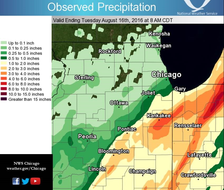 |
| Rainfall from Radar and Volunteer Observers |
 |
| Regional Rainfall from Radar and Volunteer Observers |
Local Storm Reports:
PRELIMINARY LOCAL STORM REPORT...SUMMARY
NATIONAL WEATHER SERVICE CHICAGO/ROMEOVILLE IL
1012 PM CDT MON AUG 15 2016

..TIME...   ...EVENT...      ...CITY LOCATION...     ...LAT.LON...
..DATE...   ....MAG....      ..COUNTY LOCATION..ST.. ...SOURCE....
            ..REMARKS..

0500 PM     HEAVY RAIN       5 E ASHKUM              40.88N 87.86W
08/15/2016  M3.10 INCH       IROQUOIS           IL   COCORAHS

            RAINFALL TOTAL SINCE 7 AM. 2.15 THIS AFTERNOON. MINOR
            FLOODING REPORTED.

0600 PM     FLOOD            PONTIAC                 40.88N 88.64W
08/15/2016                   LIVINGSTON         IL   TRAINED SPOTTER

            WATER ON THE ROADS AT MOULTON AND COURT STREET IN
            PONTIAC. ROAD WAS CLOSED.

0730 PM     HEAVY RAIN       MOMENCE                 41.16N 87.66W
08/15/2016  M4.75 INCH       KANKAKEE           IL   PUBLIC

0730 PM     FLOOD            LOWELL                  41.29N 87.41W
08/15/2016                   LAKE               IN   PUBLIC

            STANDING WATER OVER NEIGHBORHOOD ROADS IN LOWELL.

0815 PM     HEAVY RAIN       2 WNW VALPARAISO        41.49N 87.09W
08/15/2016  M3.32 INCH       PORTER             IN   COCORAHS

            IN LAST 4.5 HOURS.

0830 PM     FLOOD            1 E VALPARAISO          41.48N 87.03W
08/15/2016                   PORTER             IN   COCORAHS

            STANDING WATER OVER ROUTE 2 ONE MILE EAST OF VALPARAISO.

0900 PM     HEAVY RAIN       3 NW DE MOTTE           41.23N 87.24W
08/15/2016  M3.20 INCH       LAKE               IN   MESONET

1000 PM     HEAVY RAIN       VALPARAISO              41.48N 87.05W
08/15/2016  M2.84 INCH       PORTER             IN   ASOS

1000 PM     HEAVY RAIN       KANKAKEE                41.12N 87.86W
08/15/2016  M4.41 INCH       KANKAKEE           IL   AWOS
| Local Rainfall Reports from August 15th |
Public Information Statement
National Weather Service Chicago IL
0908 AM CDT Tue Aug 16 2016

...Morning Rainfall Roundup...

   The following are rain amounts for the previous 24-hours
   as measured in the morning by NWS Cooperative Observers
   and CoCoRaHS observers.
   Observations are usually taken between 6 AND 8 AM.

   24-hour rainfall amounts
       for Tuesday(08/16/16)...


Illinois                                       Rain
  Location (County):                           fall (inches)

  Momence (Kankakee)...........................4.75
  Kankakee (Kankakee)..........................4.60
  Ashkum 5.6E (Iroquois).......................4.14
  Chebanse (Kankakee)..........................4.10
  Momence 6SSW (Kankakee)......................4.00
  St Anne (Kankakee)...........................3.84
  Watseka 6.9WNW (Iroquois)....................3.59
  Cissna Park 1S (Iroquois)....................3.37
  Kankakee (Kankakee)..........................3.08
  Chatsworth (Livingston)......................3.00
  Watseka (Iroquois)...........................2.70
  Paxton (Ford)................................2.69
  Gibson 6NE (Ford)............................2.45
  Milford (Iroquois)...........................2.35
  Beecher 3SSE (Will)..........................2.33
  Buckley (Iroquois)...........................2.20
  Bourbonnais (Kankakee).......................2.12
  Gibson 3WNW (Ford)...........................1.96
  Manteno 2SSE (Kankakee)......................1.96
  Gibson 2SW (Ford)............................1.86
  Monee (Will).................................1.77
  Peotone (Will)...............................1.74
  Lansing (Cook)...............................1.69
  Park Forest (Cook)...........................1.64
  Bonfield 4WSW (Kankakee).....................1.61
  Crete 3E (Will)..............................1.61
  Park Forest 1SW (Cook).......................1.54
  Homewood (Cook)..............................1.41
  Pontiac (Livingston).........................1.40
  New Lenox 3E (Will)..........................1.35
  Park Forest 1NNE (Cook)......................1.26
  Manhattan 5ENE (Will)........................1.23
  Manhattan (Will).............................1.20
  Lansing (Cook)...............................1.17
  New Lenox 2SE (Will).........................1.15
  Bonfield 4NNE (Kankakee).....................1.14
  Manhattan 2SE (Will).........................1.13
  Wilmington 3SE (Will)........................0.98
  Elwood 5NE (Will)............................0.95
  Braceville (Grundy)..........................0.91
  Dwight (Livingston)..........................0.88
  Dixon (Lee)..................................0.78
  Dixon 2SW (Lee)..............................0.74
  Dwight 4NNW (Grundy).........................0.68
  Coal City (Grundy)...........................0.66
  Coal City 3N (Grundy)........................0.65
  Chicago 6ESE (Cook)..........................0.63
  Wilmington 6NW (Will)........................0.63
  Oak Lawn 2SE (Cook)..........................0.56
  Alsip (Cook).................................0.56
  Coal City 4NNW (Grundy)......................0.54
  Carbon Hill 3.1N (Grundy)....................0.54
  Channahon 2SSE (Will)........................0.54
  Minooka (Grundy).............................0.51
  Oak Lawn (Cook)..............................0.47
  Worth (Cook).................................0.44
  Morris 2SSE (Grundy).........................0.44
  Oak Lawn 1N (Cook)...........................0.43
  Homer Glen 1ENE (Will).......................0.43
  Joliet Lock/dam (Will).......................0.43
  Oak Lawn 2WNW (Cook).........................0.41
  Lockport 1SE (Will)..........................0.40
  Joliet 2n (Will).............................0.38
  Willow Springs (Cook)........................0.37
  Midway Coop (Cook)...........................0.35
  Romeoville (Will)............................0.33
  Joliet 3WNW (Will)...........................0.32
  Cicero 2SSW (Cook)...........................0.31
  Countryside 1ENE (Cook)......................0.30
  Streator (Livingston)........................0.30
  Streator 4ENE (La Salle).....................0.29
  Midway (Cook)................................0.29
  Morris (Grundy)..............................0.29
  Burr Ridge 2SW (Du Page).....................0.28
  Roselle 1W (Du Page).........................0.27
  Winthrop Harbor 1SSW (Lake)..................0.25
  Plainfield 3SE (Will)........................0.24
  Beach Park 1W (Lake).........................0.23
  La Grange Park 1SSW (Cook)...................0.19
  Westmont (Du Page)...........................0.19
  Oak Park 2S (Cook)...........................0.18
  Chicago 6NNE (Cook)..........................0.17
  Dixon 3NNW (Lee).............................0.17
  Algonquin 1N (McHenry).......................0.17
  Gurnee 2NE (Lake)............................0.16
  Genoa (De Kalb)..............................0.15
  Aurora (Kane)................................0.14
  Bolingbrook 3NE (Du Page)....................0.14
  Ottawa 2N (La Salle).........................0.14
  Rogers Park 2SW (Cook).......................0.13
  Mundelein (Lake).............................0.13
  Ottawa (La Salle)............................0.13
  Oak Park 1NNE (Cook).........................0.11
  Lake Villa 1SSW (Lake).......................0.11
  Ottawa 1NW (La Salle)........................0.11
  Lincolnwood 2E (Cook)........................0.10
  Libertyville 2ESE (Lake).....................0.10
  Lake Villa 2WSW (Lake).......................0.10
  Seneca 1NNE (La Salle).......................0.10
  Woodstock 1SSW (McHenry).....................0.10
  Somonauk 2NE (De Kalb).......................0.09
  Downers Grove 1S (Du Page)...................0.09
  Morris 5NNW (Grundy).........................0.09
  Lakemoor 2SE (Lake)..........................0.09
  Bull Valley 2WNW (McHenry)...................0.09
  Lakemoor 2NW (McHenry).......................0.09
  Woodstock (McHenry)..........................0.09
  Winnetka 1ESE (Cook).........................0.07
  Glencoe (Cook)...............................0.07
  Highwood 1S (Lake)...........................0.07
  Fox Lake 2SE (Lake)..........................0.07
  Mundelein 2WNW (Lake)........................0.07
  Amboy (Lee)..................................0.06
  Morris (Grundy)..............................0.06
  Botanic Gardens (Cook).......................0.06
  Downers Grove 0.4NNE (Du Page)...............0.06
  Plainfield 1SW (Will)........................0.06
  Marseilles (La Salle)........................0.06
  Harvard (McHenry)............................0.05
  Park Ridge 1WNW (Cook).......................0.05
  Elmhurst 2SE (Du Page).......................0.05
  Plainfield 5SW (Kendall).....................0.05
  Elgin 2W (Kane)..............................0.05
  Woodstock 4SW (McHenry)......................0.05
  Rockford 2ENE (Winnebago)....................0.05
  Mchenry (McHenry)............................0.05
  Plainfield (Will)............................0.05
  Wheeling (Cook)..............................0.05
  Woodstock 5nw (McHenry)......................0.05
  Capron (Boone)...............................0.04
  Arlington Heights 1SW (Cook).................0.04
  Park Ridge (Cook)............................0.04
  Elk Grove Village 1ESE (Cook)................0.04
  Elk Grove Village 2WSW (Cook)................0.04
  Bartlett 1SE (Du Page).......................0.04
  Carol Stream (Du Page).......................0.04
  Plano (Kendall)..............................0.04
  Elburn (Kane)................................0.04
  Amboy (Lee)..................................0.04
  Wonder Lake 1WNW (McHenry)...................0.04
  Harvard 3SSE (McHenry).......................0.04
  Plainfield 3NNW (Will).......................0.04
  Rockford 3NE (Winnebago).....................0.04
  Elgin (Kane).................................0.03
  Hoffman Estates 5W (Cook)....................0.03
  Palatine 1E (Cook)...........................0.03
  Streamwood 1W (Cook).........................0.03
  Elmhurst 1ESE (Du Page)......................0.03
  Elmhurst (Du Page)...........................0.03
  Lombard 1NNW (Du Page).......................0.03
  Naperville 1NW (Du Page).....................0.03
  Elgin 2WNW (Kane)............................0.03
  Buffalo Grove 2N (Lake)......................0.03
  Rockford 1NW (Winnebago).....................0.03
  Lake Zurich (Lake)...........................0.03
  Mundelein (Lake).............................0.03
  Lisle Morton Arb (Du Page)...................0.03
  Winfield (Du Page)...........................0.03
  Barrington (Lake)............................0.02
  Elgin (Kane).................................0.02
  Elburn (Kane)................................0.02
  Aurora 4SE (Du Page).........................0.02
  Glen Ellyn 2SSE (Du Page)....................0.02
  Lisle (Du Page)..............................0.02
  Aurora 4NE (Du Page).........................0.02
  Villa Park 1NW (Du Page).....................0.02
  Oswego 5SSE (Kendall)........................0.02
  Elgin 1S (Kane)..............................0.02
  North Aurora 2NE (Kane)......................0.02
  Lily Lake 2E (Kane)..........................0.02
  Ashton (Lee).................................0.02
  Lincolnshire 1N (Lake).......................0.02
  Ohare (Cook).................................0.02
  Polo (Ogle)..................................0.02
  Aurora 4SE (Du Page).........................0.01
  Montgomery 1SSE (Kendall)....................0.01
  Batavia 1WSW (Kane)..........................0.01
  Batavia 2WNW (Kane)..........................0.01
  Batavia 1WNW (Kane)..........................0.01
  St. Charles 6NW (Kane).......................0.01
  La Salle (La Salle)..........................0.01
  Naperville 4SSW (Will).......................0.01
  Rockford (Winnebago).........................0.01
  Steward (Lee)................................0.01
  Aurora (Kane)...............................TRACE
  De Kalb (De Kalb)...........................TRACE
  West Chicago (Du Page)......................TRACE
  Earlville 3S (La Salle).....................TRACE
  Cortland (De Kalb)..........................TRACE
  De Kalb (De Kalb)...........................TRACE
  Geneva 1SSW (Kane)..........................TRACE
  Mendota (La Salle)..........................TRACE

Indiana                                        Rain
  Location (County):                           fall (inches)

  Lowell (Lake)................................5.17
  Rensselaer 8ENE (Jasper).....................4.72
  Winfield 1NE (Lake)..........................4.46
  Valparaiso 6S (Porter).......................4.34
  Wheatfield 5W (Jasper).......................4.31
  Valparaiso 6SSW (Porter).....................4.25
  De Motte 1SSW (Jasper).......................4.20
  Valparaiso (Porter)..........................4.18
  De Motte 1NNW (Jasper).......................4.17
  Valparaiso 7WSW (Porter).....................4.08
  Hebron 4NE (Porter)..........................4.01
  Valparaiso 2WNW (Porter).....................3.85
  Valparaiso 4SW (Porter)......................3.84
  Valparaiso 6WSW (Porter).....................3.83
  Valparaiso 1SE (Porter)......................3.79
  Chesterton 4E (Porter).......................3.75
  De Motte 4SW (Jasper)........................3.70
  De Motte 6S (Jasper).........................3.65
  (w9opr)Wheatfield 1ENE (Jasper)..............3.65
  Portage 3E (Porter)..........................3.65
  Valparaiso 1NE (Porter)......................3.63
  Remington (Jasper)...........................3.60
  Remington (Jasper)...........................3.48
  Rensselaer 10NNE (Jasper)....................3.40
  Rensselaer 8NE (Jasper)......................3.39
  Rensselaer 5NW (Jasper)......................3.30
  Kentland 2SSE (Newton).......................3.13
  Wheatfield 3S (Jasper).......................3.12
  Earl Park 2SSE (Benton)......................3.00
  Kentland (Newton)............................2.98
  Mount Ayr 2NNE (Newton)......................2.97
  Rensselaer 2SSW (Jasper).....................2.96
  Hobart 2E (Lake).............................2.95
  Rensselaer (Jasper)..........................2.80
  Rensselaer 2N (Jasper).......................2.78
  Crown Point 2WSW (Lake)......................2.76
  Morocco (Newton).............................2.70
  Rensselaer 4N (Jasper).......................2.62
  Valparaiso 6NW (Porter)......................2.61
  Gary 5ENE (Lake).............................2.58
  Portage 1ESE (Porter)........................2.49
  Hobart 1NNW (Lake)...........................2.30
  Crown Point 1N (Lake)........................2.20
  Hobart 1SSW (Lake)...........................2.13
  (w9mal)Merrillville 2NNW (Lake)..............2.07
  Schererville 2ESE (Lake).....................1.97
  Gary 4SSW (Lake).............................1.92
  Dyer 1WNW (Lake).............................1.70
  Schererville 1E (Lake).......................1.64
|
August 18 (early morning)
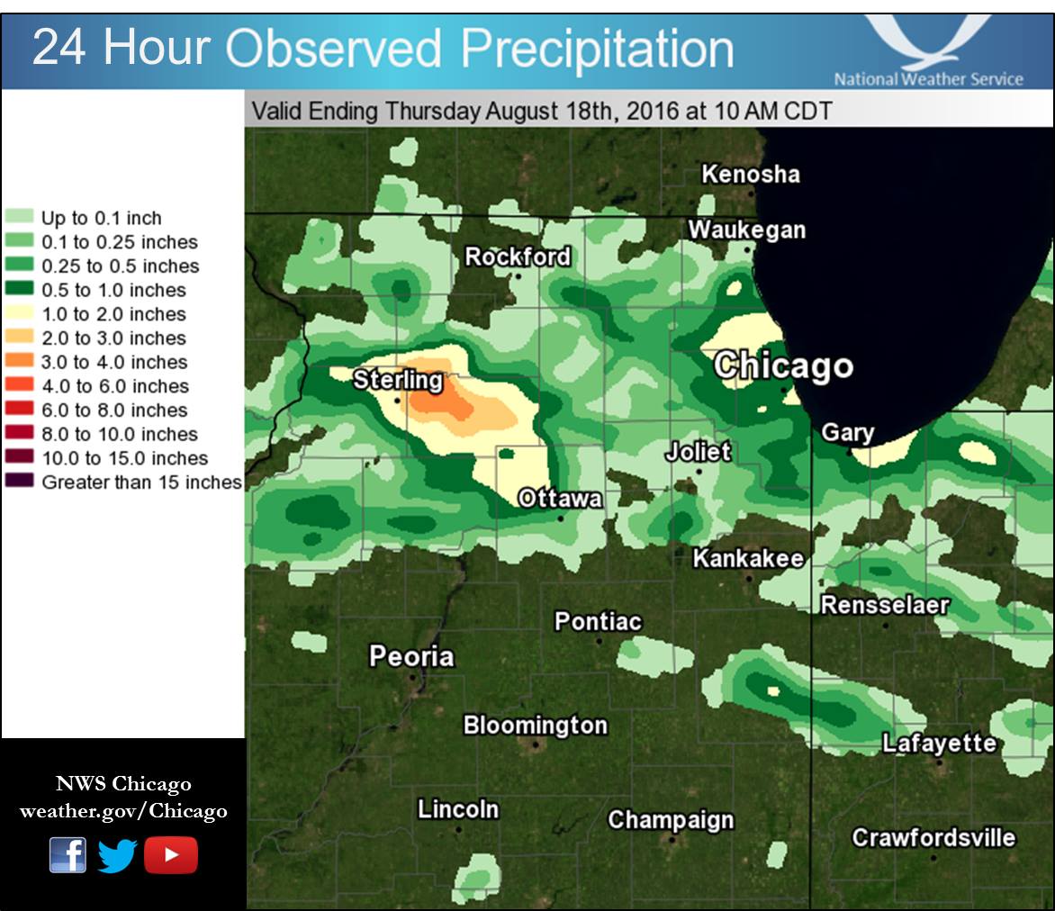 |
| Rainfall from Radar and Volunteer Observers |
Local Storm Reports:
PRELIMINARY LOCAL STORM REPORT
NATIONAL WEATHER SERVICE CHICAGO/ROMEOVILLE IL
449 AM CDT THU AUG 18 2016

..TIME...   ...EVENT...      ...CITY LOCATION...     ...LAT.LON...
..DATE...   ....MAG....      ..COUNTY LOCATION..ST.. ...SOURCE....
            ..REMARKS..

0350 AM     FLASH FLOOD      DIXON                   41.85N 89.48W
08/18/2016                   LEE                IL   EMERGENCY MNGR

            ROUTE 26 AT ROUTE 52 CLOSED. WATER UP TO 2 FEET. BUSINESS
            NEARBY FLOODED.
0314 AM     FLOOD            DIXON                   41.85N 89.48W
08/18/2016                   LEE                IL   LAW ENFORCEMENT

            STREET FLOODING IN THE DIXON AREA.

0235 AM     HEAVY RAIN       5 WSW DIXON             41.82N 89.57W
08/18/2016  M2.35 INCH       LEE                IL   COCORAHS
Public Information Statement
National Weather Service Chicago IL
0855 AM CDT Thu Aug 18 2016

...Morning Rainfall Roundup...

   The following are rain amounts for the previous 24-hours
   as measured in the morning by NWS Cooperative Observers
   and CoCoRaHS observers.
   Observations are usually taken between 6 AND 8 AM.

   24-hour rainfall amounts
       for Thursday(08/18/16)...


Illinois                                       Rain
  Location (County):                           fall (inches)

  Dixon 2SW (Lee)..............................5.35
  Dixon 3NNW (Lee).............................3.38
  Amboy (Lee)..................................2.08
  Amboy (Lee)..................................1.98
  Park Ridge 1WNW (Cook).......................1.87
  Elmhurst 2SE (Du Page).......................1.76
  Ashton (Lee).................................1.66
  Wheeling (Cook)..............................1.65
  Mendota (La Salle)...........................1.62
  Milford (Iroquois)...........................1.40
  Paw Paw (Lee)................................1.25
  Steward (Lee)................................1.25
  Elmhurst 1ESE (Du Page)......................1.17
  Arlington Heights 1SW (Cook).................1.02
  Earlville 3S (La Salle)......................1.00
  Roselle 1ESE (Du Page).......................0.98
  Elmhurst (Du Page)...........................0.95
  Park Ridge (Cook)............................0.90
  Lisle Morton Arb (Du Page)...................0.89
  Libertyville 2ESE (Lake).....................0.83
  Ohare (Cook).................................0.78
  Park Forest 1SW (Cook).......................0.77
  Burr Ridge 2SW (Du Page).....................0.73
  Crete 3E (Will)..............................0.72
  Rochelle (Ogle)..............................0.71
  Buffalo Grove 2N (Lake)......................0.69
  Lincolnwood 3E (Cook)........................0.68
  Lincolnshire 1.3WSW (Lake)...................0.66
  Palatine 1E (Cook)...........................0.65
  Villa Park 1NW (Du Page).....................0.65
  Downers Grove 0.4NNE (Du Page)...............0.63
  Glencoe (Cook)...............................0.62
  Ottawa 2N (La Salle).........................0.61
  Elk Grove Village 1ESE (Cook)................0.58
  Riverwoods (Lake)............................0.58
  Lincolnwood 2E (Cook)........................0.57
  Bannockburn (Lake)...........................0.53
  Ottawa 1NW (La Salle)........................0.53
  Elgin (Kane).................................0.51
  Hoffman Estates 5W (Cook)....................0.51
  Elgin 1S (Kane)..............................0.51
  Winthrop Harbor 1SSW (Lake)..................0.49
  Westmont (Du Page)...........................0.48
  Lombard 1NNW (Du Page).......................0.43
  Cicero 2SSW (Cook)...........................0.41
  Roselle 1W (Du Page).........................0.41
  Elgin 2W (Kane)..............................0.39
  Beach Park 1W (Lake).........................0.37
  Lake Villa 1SSW (Lake).......................0.37
  Ottawa (La Salle)............................0.36
  Watseka (Iroquois)...........................0.36
  Willow Springs (Cook)........................0.36
  Lake Villa 2WSW (Lake).......................0.35
  Park Forest (Cook)...........................0.35
  Park Forest 1NNE (Cook)......................0.34
  Waukegan (Lake)..............................0.33
  La Salle (La Salle)..........................0.32
  Watseka 6.9WNW (Iroquois)....................0.31
  Belvidere (Boone)............................0.29
  Bolingbrook 3NE (Du Page)....................0.26
  Wonder Lake 1WNW (McHenry)...................0.26
  St. Charles 6NW (Kane).......................0.24
  Gilberts (Kane)..............................0.24
  Elgin (Kane).................................0.23
  Homer Glen 1ENE (Will).......................0.23
  Elgin 2WNW (Kane)............................0.22
  Manhattan 5ENE (Will)........................0.22
  Manhattan (Will).............................0.22
  Midway (Cook)................................0.22
  Peru (La Salle)..............................0.22
  La Grange Park 1SSW (Cook)...................0.21
  Naperville 2ESE (Du Page)....................0.19
  West Chicago (Du Page).......................0.18
  Oak Lawn (Cook)..............................0.18
  New Lenox 4SE (Will).........................0.18
  Woodstock 4SW (McHenry)......................0.17
  Lisle (Du Page)..............................0.16
  Carol Stream (Du Page).......................0.16
  Barrington (Lake)............................0.15
  Dwight (Livingston)..........................0.15
  Mundelein (Lake).............................0.15
  Midway Coop (Cook)...........................0.15
  Oak Park 1NNE (Cook).........................0.14
  Geneva 2WSW (Kane)...........................0.14
  Algonquin 1N (McHenry).......................0.14
  Naperville 2ESE (Du Page)....................0.12
  Geneva 4WSW (Kane)...........................0.12
  North Aurora 2NE (Kane)......................0.11
  St. Charles (Kane)...........................0.11
  Aurora (Kane)................................0.10
  Plano (Kendall)..............................0.10
  Highwood 1S (Lake)...........................0.10
  Capron (Boone)...............................0.09
  Batavia 2WNW (Kane)..........................0.08
  Geneva 1SSW (Kane)...........................0.08
  Elburn (Kane)................................0.07
  Aurora 4SE (Du Page).........................0.07
  Beecher 3ENE (Will)..........................0.07
  Naperville 4SSW (Will).......................0.07
  Lake Zurich (Lake)...........................0.07
  Aurora (Kane)................................0.06
  Bartlett 1SE (Du Page).......................0.06
  Montgomery 1SSE (Kendall)....................0.06
  Batavia 1WNW (Kane)..........................0.06
  Lakemoor 2SE (Lake)..........................0.06
  Fox Lake 2SE (Lake)..........................0.06
  Woodstock 1SSW (McHenry).....................0.06
  Batavia (Kane)...............................0.05
  Aurora 4SE (Du Page).........................0.05
  Batavia 1WSW (Kane)..........................0.05
  Sheridan 3SSE (La Salle).....................0.05
  Mchenry (McHenry)............................0.05
  De Kalb (De Kalb)............................0.04
  Seneca 2SSW (La Salle).......................0.04
  Joliet 3WNW (Will)...........................0.04
  Plainfield 3NNW (Will).......................0.04
  Homer Glen 2NW (Will)........................0.04
  Plainfield 1SW (Will)........................0.04
  Joliet 2n (Will).............................0.04
  Plainfield (Will)............................0.04
  Genoa (De Kalb)..............................0.03
  Hebron (McHenry).............................0.03
  De Kalb (De Kalb)............................0.03
  Oswego 5SSE (Kendall)........................0.03
  Harvard 3SSE (McHenry).......................0.03
  Elwood 5NE (Will)............................0.03
  New Lenox 2SE (Will).........................0.03
  Oak Park 2S (Cook)...........................0.02
  Oak Lawn 2WNW (Cook).........................0.02
  Cortland (De Kalb)...........................0.02
  Gurnee 2W (Lake).............................0.02
  Seneca 1NNE (La Salle).......................0.02
  Bull Valley 2WNW (McHenry)...................0.02
  Wilmington 3SE (Will)........................0.02
  Lockport 1SE (Will)..........................0.02
  Romeoville (Will)............................0.02
  Monee (Will).................................0.02
  Ottawa (La Salle)............................0.02
  Chicago Ridge (Cook).........................0.01
  Plainfield 5SW (Kendall).....................0.01
  Lockport 3ESE (Will).........................0.01
  Plainfield 2SSE (Will).......................0.01
  Rockford 1NW (Winnebago).....................0.01
  Mundelein (Lake).............................0.01
  Chicago 6ESE (Cook).........................TRACE
  Oak Lawn 2SE (Cook).........................TRACE
  Worth (Cook)................................TRACE
  Elk Grove Village 2WSW (Cook)...............TRACE
  Streator 4ENE (La Salle)....................TRACE
  Beecher 3SSE (Will).........................TRACE
  Channahon 2SSE (Will).......................TRACE
  Rockford 3NE (Winnebago)....................TRACE
  Rockford (Winnebago)........................TRACE
  Woodstock 5nw (McHenry).....................TRACE

Indiana                                        Rain
  Location (County):                           fall (inches)

  De Motte 4SW (Jasper)........................0.50
  De Motte 1NNW (Jasper).......................0.24
  Gary 5ENE (Lake).............................0.22
  De Motte 1SSW (Jasper).......................0.21
  Wheatfield 5W (Jasper).......................0.12
  Dyer 1WNW (Lake).............................0.07
  Crown Point 2WSW (Lake)......................0.04
  Rensselaer 8NE (Jasper)......................0.03
  Schererville 1E (Lake).......................0.03
  Crown Point 1N (Lake)........................0.02
  Valparaiso 4SW (Porter)......................0.02
  Portage 3E (Porter)..........................0.02
  Valparaiso 1NE (Porter)......................0.01
  Rensselaer 4N (Jasper)......................TRACE
  Hobart 1SSW (Lake)..........................TRACE
  Valparaiso 2WNW (Porter)....................TRACE
  Hebron 4NE (Porter).........................TRACE
  Valparaiso 2NW (Porter).....................TRACE
  Valparaiso (Porter).........................TRACE

$$
August 18 (afternoon and evening)
Public Information Statement
National Weather Service Chicago IL
0342 PM CDT Fri Aug 19 2016

...Morning Rainfall Roundup...

   The following are rain amounts for the previous 24-hours
   as measured in the morning by NWS Cooperative Observers
   and CoCoRaHS observers.
   Observations are usually taken between 6 AND 8 AM.

   24-hour rainfall amounts
       for Friday(08/19/16)...


Illinois                                       Rain
  Location (County):                           fall (inches)

  Ashkum 5.6E (Iroquois).......................3.66
  Bourbonnais (Kankakee).......................2.91
  Chatsworth (Livingston)......................2.88
  Elgin 1S (Kane)..............................2.10
  De Kalb (De Kalb)............................1.87
  De Kalb (De Kalb)............................1.46
  Marseilles (La Salle)........................1.43
  La Salle (La Salle)..........................1.40
  Peotone (Will)...............................1.38
  Sterling 4NE (Lee)...........................1.33
  Cortland (De Kalb)...........................1.26
  Chicago 6ESE (Cook)..........................1.25
  De Kalb 2NNE (De Kalb).......................1.22
  Peru (La Salle)..............................1.21
  Midway (Cook)................................1.20
  Milford (Iroquois)...........................1.20
  Sheridan 3SSE (La Salle).....................1.16
  Watseka 6.9WNW (Iroquois)....................1.14
  Pontiac 1SE (Livingston).....................1.09
  Coal City 3N (Grundy)........................1.08
  Oak Park 1NNE (Cook).........................0.98
  Elk Grove Village 2WSW (Cook)................0.93
  Ashton (Lee).................................0.85
  Harvard 3SSE (McHenry).......................0.83
  Mendota (La Salle)...........................0.83
  Cissna Park 1S (Iroquois)....................0.81
  Paxton (Ford)................................0.80
  Monee (Will).................................0.78
  Mazon 0.5ENE (Grundy)........................0.77
  Byron 3N (Ogle)..............................0.77
  Crete 3E (Will)..............................0.77
  Gibson 6NE (Ford)............................0.76
  Pontiac 1ESE (Livingston)....................0.75
  Rochelle (Ogle)..............................0.75
  Kankakee (Kankakee)..........................0.71
  Pontiac (Livingston).........................0.71
  Pontiac (Livingston).........................0.70
  Homewood (Cook)..............................0.69
  Steward (Lee)................................0.69
  Lake Bluff 1W (Lake).........................0.67
  North Utica 6N (La Salle)....................0.66
  Braceville (Grundy)..........................0.65
  Dwight 4NNW (Grundy).........................0.63
  Dixon 2SW (Lee)..............................0.63
  Wilmington 6NW (Will)........................0.63
  Dixon 3NNW (Lee).............................0.62
  Chicago 5NE (Cook)...........................0.61
  Bonfield 4NNE (Kankakee).....................0.61
  Sublette (Lee)...............................0.61
  Oak Park 2S (Cook)...........................0.60
  Elk Grove Village 1ESE (Cook)................0.57
  Amboy (Lee)..................................0.56
  Rochelle (Ogle)..............................0.56
  Park Forest 1NNE (Cook)......................0.55
  Watseka (Iroquois)...........................0.55
  Burnham-hegewisch 2NNW (Cook)................0.54
  Chebanse (Kankakee)..........................0.54
  Park Forest (Cook)...........................0.52
  Amboy (Lee)..................................0.51
  Bridgeview 1NNW (Cook).......................0.51
  Channahon 2SSE (Will)........................0.51
  Woodstock 5nw (McHenry)......................0.51
  Montgomery 1SSE (Kendall)....................0.50
  Ottawa (La Salle)............................0.50
  Roscoe 2ESE (Winnebago)......................0.48
  Roscoe 2se (Winnebago).......................0.48
  Lansing (Cook)...............................0.46
  Ottawa 1NW (La Salle)........................0.46
  Beecher 3ENE (Will)..........................0.46
  Midway Coop (Cook)...........................0.45
  Highwood 1S (Lake)...........................0.44
  Somonauk 2NE (De Kalb).......................0.43
  Rockford 3NE (Winnebago).....................0.43
  Alsip (Cook).................................0.42
  Gibson 3WNW (Ford)...........................0.39
  Park Forest 1SW (Cook).......................0.38
  Park Ridge (Cook)............................0.37
  Oak Lawn 2WNW (Cook).........................0.37
  Batavia (Kane)...............................0.36
  Dwight (Livingston)..........................0.35
  Batavia 1WSW (Kane)..........................0.35
  Paw Paw (Lee)................................0.35
  Capron (Boone)...............................0.33
  Gibson 2SW (Ford)............................0.33
  Ottawa 2N (La Salle).........................0.32
  Morris (Grundy)..............................0.32
  Rockford 2ENE (Winnebago)....................0.31
  Coal City 4NNW (Grundy)......................0.30
  Carbon Hill 3.1N (Grundy)....................0.30
  Morris 5NNW (Grundy).........................0.29
  Elgin 2WNW (Kane)............................0.29
  Worth (Cook).................................0.28
  Buckley (Iroquois)...........................0.27
  Aurora (Kane)................................0.26
  Manhattan 2SE (Will).........................0.26
  Marseilles 5WNW (La Salle)...................0.25
  Wilmington 3SE (Will)........................0.25
  Elburn (Kane)................................0.24
  Chicago Ridge (Cook).........................0.23
  Park Ridge 1WNW (Cook).......................0.23
  Villa Park 1NW (Du Page).....................0.23
  Beecher 3SSE (Will)..........................0.23
  Belvidere (Boone)............................0.22
  Earlville 3S (La Salle)......................0.22


Indiana                                        Rain
  Location (County):                           fall (inches)

  Rensselaer 5NW (Jasper)......................2.61
  Rensselaer 2SSW (Jasper).....................2.56
  Chesterton 4E (Porter).......................2.52
  Porter 1S (Porter)...........................1.82
  Portage 3E (Porter)..........................1.70
  Rensselaer (Jasper)..........................1.64
  Hobart 2E (Lake).............................1.48
  Portage 1ESE (Porter)........................1.39
  Valparaiso 1NE (Porter)......................1.34
  Kentland (Newton)............................1.30
  Valparaiso 2NW (Porter)......................1.11
  Hobart 1SSW (Lake)...........................1.03
  Morocco (Newton).............................1.03
  Fair Oaks 6SW (Newton).......................0.95
  Gary 5ENE (Lake).............................0.94
  Rensselaer 8NE (Jasper)......................0.87
  Valparaiso 2WNW (Porter).....................0.86
  Mount Ayr 2NNE (Newton)......................0.84
  Valparaiso 1SE (Porter)......................0.76
  Rensselaer 8ENE (Jasper).....................0.73
  Valparaiso (Porter)..........................0.69
  Kentland 2SSE (Newton).......................0.64
  Rensselaer 2N (Jasper).......................0.63
  Lake Village 8SE (Newton)....................0.63
  Dyer 1WNW (Lake).............................0.55
  Valparaiso 3WSW (Porter).....................0.54
  (w9mal)Merrillville 2NNW (Lake)..............0.50
  Crown Point 2WSW (Lake)......................0.44
  Wheatfield 3S (Jasper).......................0.43
  Gary 4SSW (Lake).............................0.42
  Remington (Jasper)...........................0.42
  Rensselaer 10NNE (Jasper)....................0.35
  Rensselaer 4N (Jasper).......................0.35
  Hebron 1NW (Porter)..........................0.32
  Remington (Jasper)...........................0.27
  De Motte 6S (Jasper).........................0.20


$$
Rivers
|
|
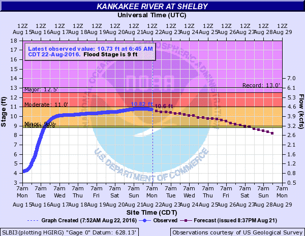 |
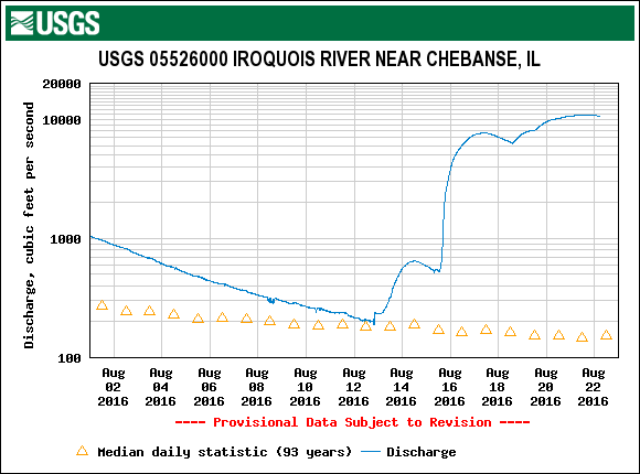
| Hydrograph of the Iroquois River at Chebanse, IL. The increase in flow was from around 200 cfs to over 10,000 cfs over about only a three day span. | Hydrograph of the Kankakee River at Shelby, IN. |
 |
Media use of NWS Web News Stories is encouraged! |
|