
Numerous severe thunderstorms are expected across a broad region from the Ohio Valley to the Mid-Atlantic and Northeast States today into tonight. Swaths of damaging wind gusts are expected and some tornadoes are possible. Bertha is expected to bring tropical storm conditions to portions of the Gulf Coast from the Florida Panhandle westward to southeastern Louisiana later today and Wednesday. Read More >
Fast Facts
Snow/Ice Totals
 |
| Snow map updates between 8 and 10 a.m. |
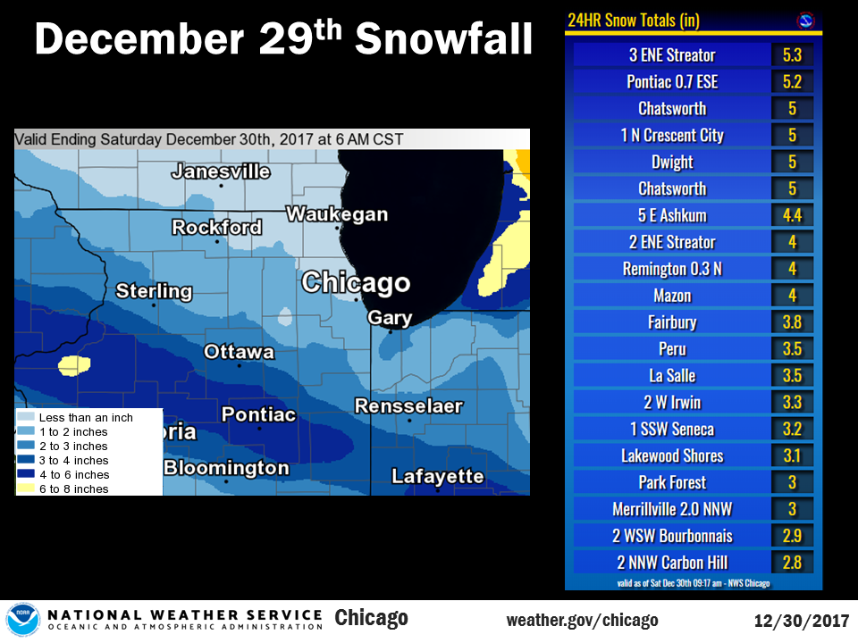
Public Information Statement
National Weather Service Chicago IL
0935 AM CST Sat Dec 30 2017

...Morning Snowfall Roundup...

   The following are snow amounts for the previous 24 hours
   as measured in the morning by NWS Cooperative Observers
   and CoCoRaHS observers.
   Observations are usually taken at 7 AM.

   24-hour Snowfall Amounts for Saturday(12/30/17)...


Northern Illinois                              Snow
  Location (County):                           fall(inches)

  Streator 4ENE (La Salle)......................5.3
  Pontiac 1ESE (Livingston).....................5.2
  Chatsworth (Livingston).......................5.0
  Dwight (Livingston)...........................5.0
  Watseka 6.9WNW (Iroquois).....................5.0
  Chatsworth (Livingston).......................5.0
  Ashkum 5.6E (Iroquois)........................4.4
  Amboy (Lee)...................................4.1
  Mazon 0.5ENE (Grundy).........................4.0
  Streator (Livingston).........................4.0
  Fairbury (Livingston).........................3.8
  La Salle (La Salle)...........................3.5
  Peru 1ENE (La Salle)..........................3.5
  Herscher 3E (Kankakee)........................3.3
  Seneca 2SSW (La Salle)........................3.2
  Wilmington 3SE (Will).........................3.1
  Park Forest (Cook)............................3.0
  Kankakee 4WNW (Kankakee)......................2.9
  Morris 6ESE (Grundy)..........................2.8
  Ottawa 1NW (La Salle).........................2.7
  St Anne (Kankakee)............................2.7
  Somonauk 2NE (De Kalb)........................2.6
  Morris (Grundy)...............................2.6
  Bonfield 4WSW (Kankakee)......................2.5
  Joliet Lock/dam (Will)........................2.5
  Coal City 4NNW (Grundy).......................2.3
  Carbon Hill 3.1N (Grundy).....................2.3
  Peotone (Will)................................2.3
  Genoa (De Kalb)...............................2.1
  Geneva 1SSW (Kane)............................2.1
  Bourbonnais (Kankakee)........................2.0
  Wheaton 2NNE (Du Page)........................2.0
  New Lenox 2SE (Will)..........................2.0
  Lockport 1SE (Will)...........................2.0
  Paw Paw (Lee).................................2.0
  Paxton (Ford).................................2.0
  Manhattan (Will)..............................1.9
  New Lenox 3E (Will)...........................1.8
  Romeoville (Will).............................1.7
  Downers Grove 0.4NNE (Du Page)................1.6
  Oak Lawn (Cook)...............................1.5
  Alsip (Cook)..................................1.5
  Naperville 2ESE (Du Page).....................1.5
  Geneva 4WSW (Kane)............................1.5
  Lily Lake 2E (Kane)...........................1.5
  Elburn (Kane).................................1.5
  Rochelle (Ogle)...............................1.5
  Willow Springs (Cook).........................1.5
  De Kalb (De Kalb).............................1.4
  Oak Park 2S (Cook)............................1.4
  Sugar Grove 1NE (Kane)........................1.4
  Batavia 2WNW (Kane)...........................1.4
  Ashton (Lee)..................................1.4
  Joliet 2n (Will)..............................1.4
  Plainfield (Will).............................1.4
  Batavia (Kane)................................1.3
  Chicago Ridge (Cook)..........................1.3
  Worth (Cook)..................................1.3
  Elburn (Kane).................................1.3
  Batavia 1WNW (Kane)...........................1.3
  Algonquin 1N (McHenry)........................1.3
  Byron 3N (Ogle)...............................1.3
  Crete 3E (Will)...............................1.3
  Rockford 1NW (Winnebago)......................1.3
  Rockford (Winnebago)..........................1.3
  Elburn (Kane).................................1.2
  Midway Coop (Cook)............................1.2
  Westmont (Du Page)............................1.2
  Woodstock 5nw (McHenry).......................1.2
  Elk Grove Village 1ESE (Cook).................1.1
  Elgin 2W (Kane)...............................1.1
  Elgin (Kane)..................................1.0
  Chicago 6ESE (Cook)...........................1.0
  Machesney Park 3ENE (Winnebago)...............1.0
  Mundelein (Lake)..............................1.0
  Elk Grove Village 2WSW (Cook).................0.9
  Schaumburg 2E (Cook)..........................0.8
  Riverwoods (Lake).............................0.8
  Roscoe 2ESE (Winnebago).......................0.8
  Ohare (Cook)..................................0.8
  Roscoe 2se (Winnebago)........................0.8
  Crystal Lake 1WSW (McHenry)...................0.8
  Hoffman Estates 5W (Cook).....................0.7
  Park Ridge 1WNW (Cook)........................0.7
  Harwood Heights (Cook)........................0.7
  Oak Park 1NNE (Cook)..........................0.7
  Lincolnwood 2E (Cook).........................0.7
  Wonder Lake 1WNW (McHenry)....................0.7
  Palatine 1E (Cook)............................0.6
  Aurora (Kane).................................0.5
  Botanic Gardens (Cook)........................0.5
  Park Ridge (Cook).............................0.5
  Countryside 1ENE (Cook).......................0.5
  La Grange Park 1SSW (Cook)....................0.5
  Waukegan 2N (Lake)............................0.5
  Capron (Boone)................................0.4

Northwest Indiana                              Snow
  Location (County):                           fall(inches)

  Remington (Jasper)............................4.0
  (w9mal)Merrillville 2NNW (Lake)...............3.0
  Portage 3E (Porter)...........................3.0
  Morocco (Newton)..............................2.5
  Rensselaer (Jasper)...........................2.5
  Dyer 1WNW (Lake)..............................2.2
  De Motte 1NNW (Jasper)........................2.0
  De Motte 4SW (Jasper).........................2.0
  (w9opr)Wheatfield 1ENE (Jasper)...............2.0
  Gary 5ENE (Lake)..............................2.0
  Crown Point (Lake)............................1.8
  Portage 1ESE (Porter).........................1.7
  Valparaiso 6SSW (Porter)......................1.5
  Valparaiso 6WSW (Porter)......................1.5
  Valparaiso 4SW (Porter).......................1.2
  Munster 2NNW (Lake)...........................1.1
Storm Reports
Map of Snowfall Local Storm Reports
210

NWUS53 KLOT 210314

LSRLOT


Preliminary Local Storm Report

National Weather Service Chicago IL

1014 PM CDT Mon Jul 20 2026


..TIME...   ...EVENT...      ...CITY LOCATION...     ...LAT.LON...

..DATE...   ....MAG....      ..COUNTY LOCATION..ST.. ...SOURCE....

            ..REMARKS..


0730 PM     Misc Mrn/Srf Hzd 3 NNW Lake Station      41.62N 87.26W

07/19/2026                   LMZ744             IN   Local Official


            *** 1 FATAL ***

            The Indiana DNR is reporting that a 22 year

            old man drowned in Lake Michigan at

            Marquette Park Beach. Preliminary

            information is that the individual jumped

            into waves and drifted into deeper water.

            Wave heights were estimated between 2 and 3

            feet at the time.


&&


$$


BB
 |
Media use of NWS Web News Stories is encouraged! Additional recaps can be found on the NWS Chicago Science & Past Events Page. |
|

