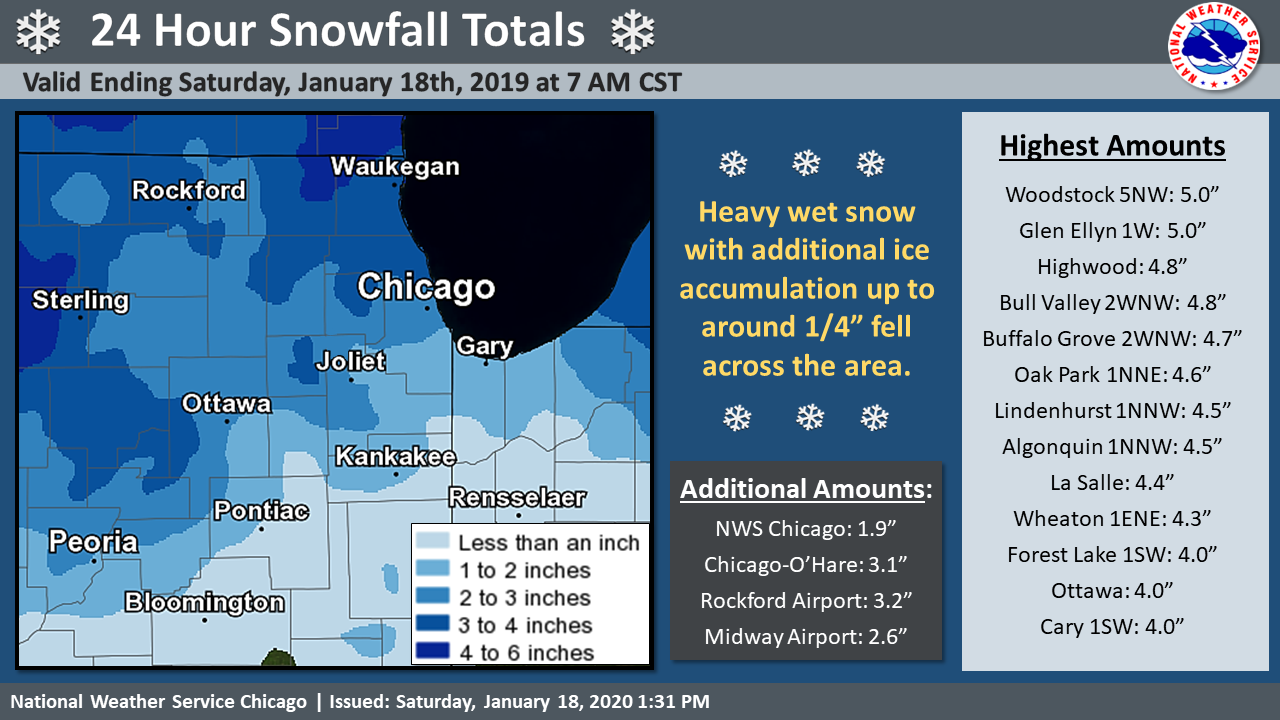
 Snowfall Totals |
Public Information Statement
National Weather Service Chicago IL
128 PM CST Sat Jan 18 2020

...SNOWFALL REPORTS...

Location                     Amount    Time/Date
Woodstock 5 NW               5.0 in    0900 AM 01/18
1 W Glen Ellyn               5.0 in    0700 AM 01/18
Highwood 0.9 S               4.8 in    0700 AM 01/18
2 WNW Bull Valley            4.8 in    0645 AM 01/18
2 N Buffalo Grove            4.7 in    0700 AM 01/18
1 NNE Oak Park               4.6 in    0600 AM 01/18
1 NNW Lindenhurst            4.5 in    0700 AM 01/18
1 NNW Algonquin              4.5 in    0600 AM 01/18
La Salle 0.1 W               4.4 in    0700 AM 01/18
Wheaton 1.5 ENE              4.3 in    0800 AM 01/18
1.1 SW Forest Lake           4.0 in    0700 AM 01/18
1 NNE Palatine               3.9 in    0700 AM 01/18
Batavia 0.7 WSW              3.6 in    0600 AM 01/18
Ottawa                       3.5 in    0755 AM 01/18
1 SSW La Grange Park         3.5 in    0730 AM 01/18
Hebron 2 WSW                 3.5 in    0700 AM 01/18
3 W Elgin                    3.5 in    0700 AM 01/18
1 SW Rogers Park             3.5 in    0700 AM 01/18
3 S Earlville                3.3 in    0600 AM 01/18
2 WNW Geneva                 3.2 in    0700 AM 01/18
Rockford Airport             3.2 in    0600 AM 01/18
Sleepy Hollow 0.7 W          3.1 in    0700 AM 01/18
Ohare Airport                3.1 in    0600 AM 01/18
Streator                     3.0 in    0700 AM 01/18
Mundelein 4 WSW              3.0 in    0700 AM 01/18
1 NE Riverwoods              3.0 in    0700 AM 01/18
1 NNW Sugar Grove            3.0 in    0700 AM 01/18
1 ESE Elk Grove Village      3.0 in    0700 AM 01/18
2 E Schaumburg               3.0 in    0700 AM 01/18
Aurora                       3.0 in    0700 AM 01/18
4 ESE Aurora                 2.9 in    0700 AM 01/18
2 SSE Plainfield             2.8 in    0700 AM 01/18
Peru 0.7 ENE                 2.8 in    0700 AM 01/18
3 NNE Campton Hills          2.8 in    0700 AM 01/18
Marengo 0.7 NNW              2.8 in    0700 AM 01/18
Capron 0.1 N                 2.8 in    0630 AM 01/18
5 NW Shorewood               2.7 in    0700 AM 01/18
Genoa                        2.7 in    0600 AM 01/18
Ashton 0.4 SSW               2.6 in    0700 AM 01/18
Burbank                      2.6 in    0600 AM 01/18
Paw Paw 2 S                  2.5 in    0700 AM 01/18
Elgin                        2.3 in    0700 AM 01/18
3 N Carbon Hill              2.2 in    0700 AM 01/18
Peotone                      2.1 in    0700 AM 01/18
Mendota 1 SE                 2.0 in    0700 AM 01/18
Homewood 0.1 ESE             2.0 in    0700 AM 01/18
Chicago 5.5 ESE              2.0 in    0600 AM 01/18
2 NE Somonauk                2.0 in    0500 AM 01/18
NWS Chicago-Romeoville       1.9 in    0600 AM 01/18
2 WNW Boone Grove            1.8 in    0715 AM 01/18
Roselle 1.2 ESE              1.5 in    0900 AM 01/18
2 NNW Merrillville           1.5 in    0700 AM 01/18
Steward 3 S                  1.5 in    0700 AM 01/18
New Lenox 3.3 E              1.5 in    0700 AM 01/18
3 NNW Lake Station           1.5 in    0700 AM 01/18
Bourbonnais                  1.5 in    0700 AM 01/18
Naperville 0.5 NW            1.5 in    0600 AM 01/18
1 N Valparaiso               1.5 in    0600 AM 01/18
Park Forest                  1.5 in    0500 AM 01/18
3 SSE St. John               1.2 in    0700 AM 01/18
Dwight                       1.0 in    0700 AM 01/18
2 N Crescent City            1.0 in    0600 AM 01/18
Wanatah                      0.8 in    0700 AM 01/18
St. Anne                     0.5 in    0700 AM 01/18
DeMotte                      0.5 in    0600 AM 01/18
Morocco                      0.5 in    0600 AM 01/18
Rensselaer 2 SW              0.3 in    0730 AM 01/18

...FREEZING RAIN REPORTS...

Location                     Amount    Time/Date
DuPage Airport               0.28 in   1200 PM 01/18
Waukegan Airport             0.28 in   1200 PM 01/18
Rockford Airport             0.27 in   1200 PM 01/18
Aurora Airport               0.27 in   1200 PM 01/18
Ohare Airport                0.26 in   1200 PM 01/18
Wheeling Airport             0.24 in   1200 PM 01/18
Valparaiso Airport           0.23 in   1200 PM 01/18
Midway Airport               0.12 in   1200 PM 01/18

Observations are collected from a variety of sources with varying
equipment and exposures. We thank all volunteer weather observers
for their dedication. Not all data listed are considered official.

$$

Petr
.

