Heat expands across the Desert Southwest, Plains, Mississippi Valley and Midwest into Monday. Fire weather concerns continue for portions of the Intermountain West. Active monsoonal moisture fuels thunderstorms over the Southwest with possible flash flooding. Tropical cyclone Fausto in the Pacific, should weaken as it approaches Hawaii; Dangerous surf, swells and rip currents are expected. Read More >
|
|
|
Fast Facts
|
|
Ice Totals
The below ice totals are from ASOS freezing rain sensors. These use an apparatus that is measuring ice accretion on a flat plane. This is therefore not representative of ice accumulation on elevated radial surfaces, such as trees and wires. For more on ice measurements and the different means, see this video from NWS Caribou, ME.
PRELIMINARY LOCAL STORM REPORT
NATIONAL WEATHER SERVICE CHICAGO IL
920 AM CST SUN JAN 9 2022

..TIME...   ...EVENT...      ...CITY LOCATION...     ...LAT.LON...
..DATE...   ....MAG....      ..COUNTY LOCATION..ST.. ...SOURCE....
            ..REMARKS..

1200 AM     FREEZING RAIN    DUPAGE AIRPORT          41.91N 88.25W
01/09/2022  M0.24 INCH       DUPAGE             IL   ASOS

            MEASURED BY THE ASOS FREEZING RAIN SENSOR.

1200 AM     FREEZING RAIN    AURORA AIRPORT          41.77N 88.47W
01/09/2022  M0.18 INCH       KANE               IL   ASOS

            MEASURED BY THE ASOS FREEZING RAIN SENSOR.

1200 AM     FREEZING RAIN    MIDWAY AIRPORT          41.78N 87.75W
01/09/2022  M0.18 INCH       COOK               IL   ASOS

            MEASURED BY THE ASOS FREEZING RAIN SENSOR.

1200 AM     FREEZING RAIN    OHARE AIRPORT           41.98N 87.90W
01/09/2022  M0.15 INCH       COOK               IL   ASOS

            MEASURED BY THE ASOS FREEZING RAIN SENSOR.

1200 AM     FREEZING RAIN    PALWAUKEE AIRPORT       42.10N 87.90W
01/09/2022  M0.15 INCH       COOK               IL   ASOS

            MEASURED BY THE ASOS FREEZING RAIN SENSOR.

1200 AM     FREEZING RAIN    VALPARAISO AIRPORT      41.45N 87.00W
01/09/2022  M0.14 INCH       PORTER             IN   ASOS

            MEASURED BY THE ASOS FREEZING RAIN SENSOR.

1200 AM     FREEZING RAIN    ROCKFORD AIRPORT        42.20N 89.10W
01/09/2022  M0.10 INCH       WINNEBAGO          IL   ASOS

            MEASURED BY THE ASOS FREEZING RAIN SENSOR.

1200 AM     FREEZING RAIN    WAUKEGAN AIRPORT        42.42N 87.87W
01/09/2022  M0.08 INCH       LAKE               IL   ASOS

            MEASURED BY THE ASOS FREEZING RAIN SENSOR.
Meteorology
 |
 |
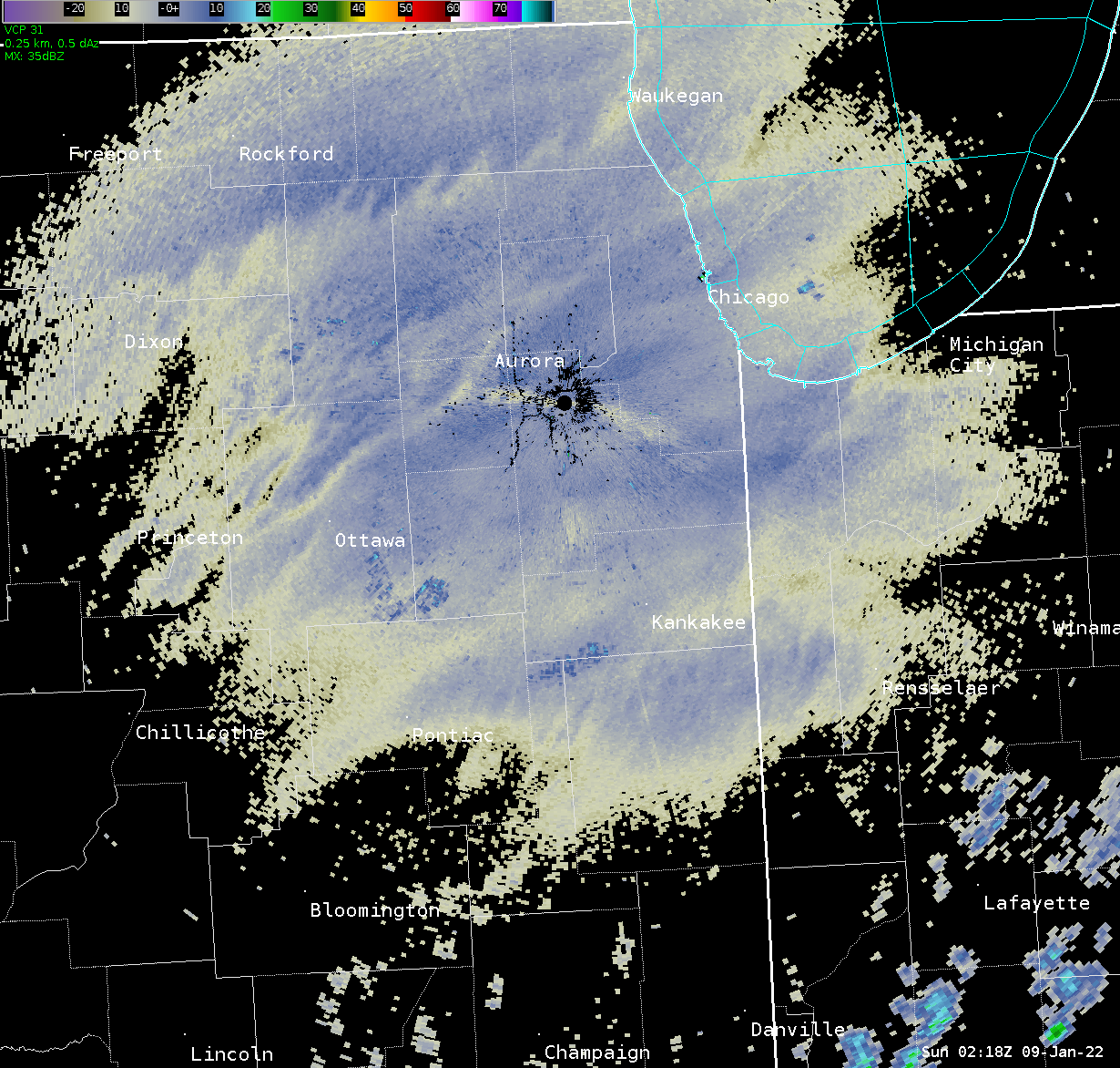 |
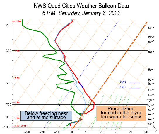
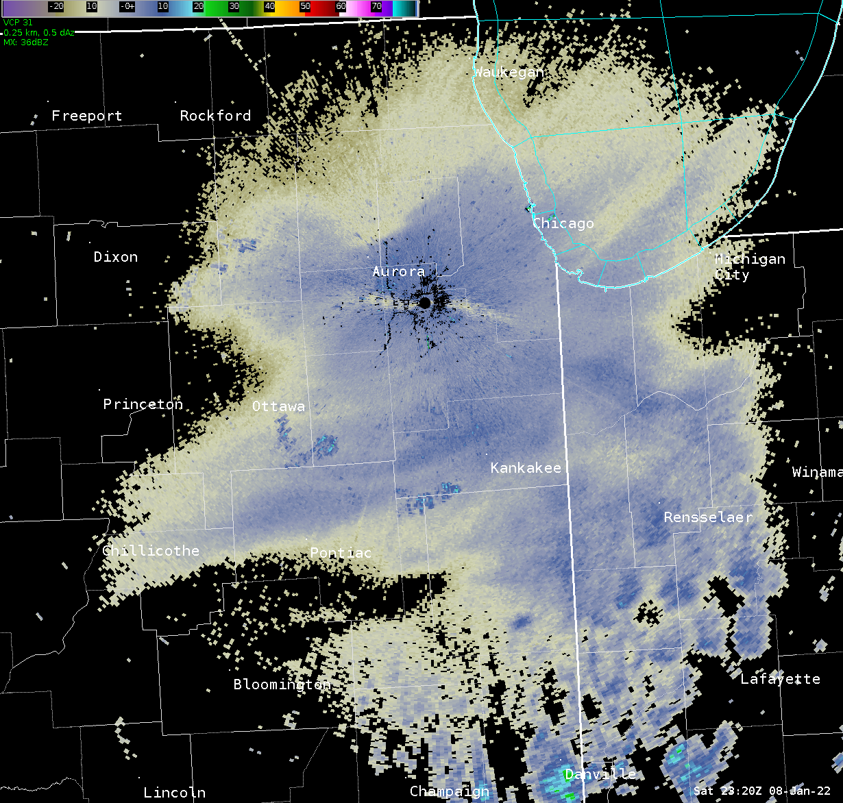
| NWS Quad Cities weather balloon data (sounding) from 6 P.M. on the evening of January 8. Drizzle / light rain was developing in the saturated layer between 5,000 and 6,000 ft AGL on this sounding. | NWS Chicago lowest level radar reflectivity at 5:20 P.M. on January 8, showing the blossomed ~10 dBZ indicative of drizzle (freezing at the surface). | NWS Chicago lowest level radar reflectivity at 9:18 P.M. on January 8, showing the continued drizzle signature over the Chicago metro. Many surfaces were still below freezing at this time. |
 |
Media use of NWS Web News Stories is encouraged! Additional recaps can be found on the NWS Chicago Past Events Page. |
|