
Widespread life-threatening flash and urban flooding will continue to pose a significant threat to life and property in south-central Texas. Catastrophic fiver flooding, with rapid rises on small streams, arroyos, and typically dry washes, is expected. Monsoonal showers persist across the Great Basin and Southwest with greatest flash flooding in southern Arizona. Read More >
|
|
Overview
Storm Reports
|
Preliminary Storm Report Map |
Preliminary Local Storm Report...Summary
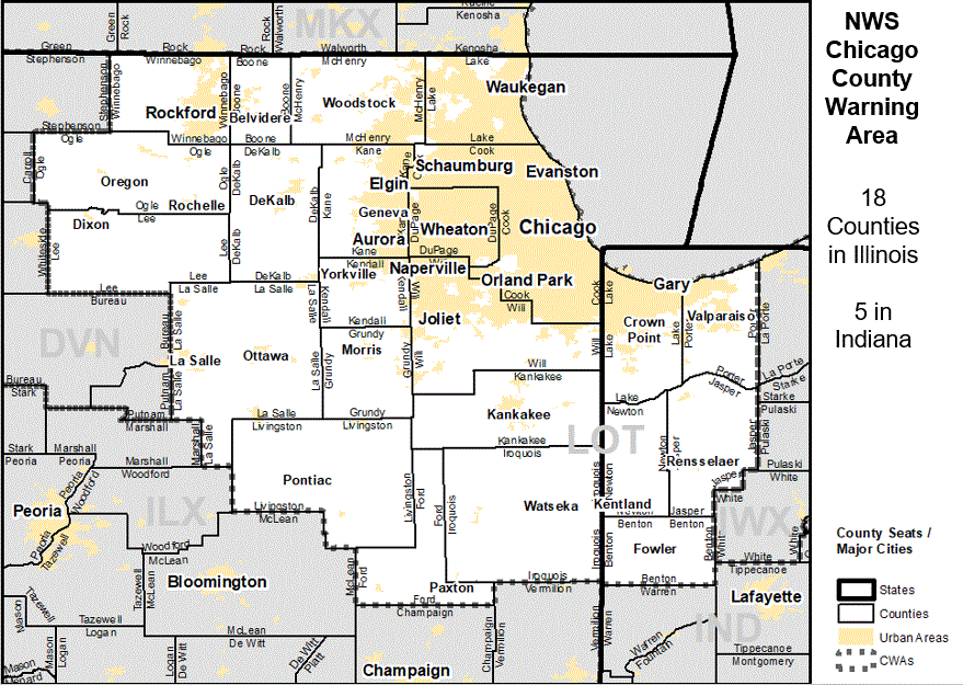
National Weather Service Chicago IL
431 PM CDT Wed Jun 26 2024
..TIME... ...EVENT... ...CITY LOCATION... ...LAT.LON...
..DATE... ....MAG.... ..COUNTY LOCATION..ST.. ...SOURCE....
..REMARKS..
0830 PM Tstm Wnd Dmg Machesney Park 42.35N 89.04W
06/22/2024 Winnebago IL Public
Large branches downed.
0830 PM Tstm Wnd Dmg Hebron 42.47N 88.43W
06/22/2024 McHenry IL Public
Numerous trees and large branches down.
0837 PM Tstm Wnd Dmg Richmond 42.48N 88.31W
06/22/2024 McHenry IL Trained Spotter
Photographs of several large tree limbs down
across Richmond shared via social media.
Some appear to be as large as 12 inches in
diameter. Time estimated from radar.
0846 PM Tstm Wnd Dmg 1 SE Antioch 42.47N 88.08W
06/22/2024 Lake IL Public
Reported via social media of a 9 inch tree
branch down just southeast of Antioch, IL.
Time approximated by radar.
0849 PM Tstm Wnd Gst 1 SSE Lake Catherine 42.47N 88.12W
06/22/2024 M59 MPH Lake IL Mesonet
Personal weather station.
0850 PM Tstm Wnd Dmg Antioch 42.48N 88.10W
06/22/2024 Lake IL Public
Large trees down near Lagoona Lake.
0857 PM Tstm Wnd Dmg Lindenhurst 42.41N 88.03W
06/22/2024 Lake IL Public
Delayed report from 6/22. Power pole snapped
and fence panel blown out in Lindenhurst.
Time estimated from radar.
0859 PM Tstm Wnd Gst 1 E Third Lake 42.37N 87.99W
06/22/2024 M60 MPH Lake IL Public
Ambient personal weather station.
0859 PM Tstm Wnd Dmg 1 NNW Long Lake 42.38N 88.14W
06/22/2024 Lake IL Public
Delayed report from 6/22. Tree downed in
Ingleside. Time estimated from radar.
0905 PM Flash Flood 2 NW Rockford 42.29N 89.12W
06/22/2024 Winnebago IL Broadcast Media
Flooding with water over the road reported
along Auburn Street, near Central Avenue.
0909 PM Tstm Wnd Gst 1 SW Beach Park 42.42N 87.87W
06/22/2024 M63 MPH Lake IL ASOS
Corrects previous non-tstm wnd gst report
from 1 SW Beach Park. ASOS station KUGN
Waukegan Airport.
0912 PM Marine Tstm Wind 3 E Waukegan 42.37N 87.80W
06/22/2024 M47 MPH LMZ740 IL Buoy
Mesonet station 45186 2 E Waukegan.
0915 PM Tstm Wnd Dmg 2 SE Zion 42.43N 87.80W
06/22/2024 Lake IL Public
Report on social media of numerous downed
trees, a couple which look like lightning
strikes, in Illinois Beach State Park. Time
approximated by radar and KUGN ASOS obs.
1019 PM Flash Flood 1 SSW Crystal Lake 42.23N 88.33W
06/22/2024 McHenry IL Trained Spotter
Video shared via social media shows over a
foot of standing water in the intersection
of U.S. 14 and Devonshire Lane.
1022 PM Tstm Wnd Gst 1 NW Cortland 41.93N 88.71W
06/22/2024 M46 MPH De Kalb IL AWOS
DKB AWOS.
1024 PM Tstm Wnd Gst 4 ESE Sycamore 41.97N 88.62W
06/22/2024 M47 MPH De Kalb IL Public
Davis personal weather station.
1025 PM Tstm Wnd Dmg 1 NE DeKalb 41.95N 88.73W
06/22/2024 De Kalb IL Public
Delayed report from 6/22. Approximately 8
inch diameter tree uprooted in DeKalb. Time
estimated from radar.
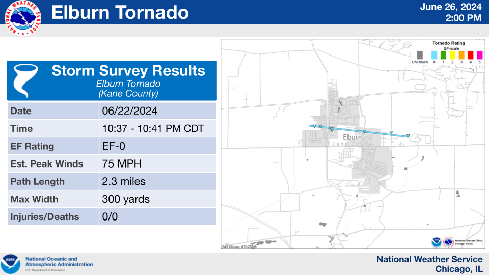
1037 PM Tornado Elburn 41.89N 88.48W
06/22/2024 Kane IL NWS Storm Survey
Delayed report from 6/22. An NWS storm
survey confirmed that an EF-0 tornado with
estimated peak winds of 75 mph, path length
of 2.3 miles, and maximum width of 300 yards
impacted Elburn, causing damage to trees and
a corn field.
1048 PM Tstm Wnd Dmg 1 NNW Batavia 41.86N 88.32W
06/22/2024 Kane IL Emergency Mngr
Numerous large branches and trees downed,
including one large Oak tree uprooted. Tree
down into powerlines.
1049 PM Tstm Wnd Dmg 2 NW Batavia 41.87N 88.35W
06/22/2024 Kane IL Public
Numerous downed trees and large branches in
the Randall Square area and near Fabyan
Pkwy.
1050 PM Tstm Wnd Dmg 1 WNW Geneva 41.89N 88.32W
06/22/2024 Kane IL Emergency Mngr
Tree reported down on a house on Maple Lane
near Center Street.
1050 PM Tstm Wnd Dmg 1 NNW Batavia 41.86N 88.32W
06/22/2024 Kane IL Public
Large branches down on Fabyan Rd.
1050 PM Tstm Wnd Dmg 1 ENE Batavia 41.86N 88.30W
06/22/2024 Kane IL Public
Reported via social media that on the
northeast side of Batavia had a lot of tree
branches down including one full grown tree.
Time approximated by radar.
1051 PM Tstm Wnd Dmg 2 NW Batavia 41.87N 88.34W
06/22/2024 Kane IL Emergency Mngr
Tree down across Randall Rd. near Fabyan
Parkway.
1054 PM Tstm Wnd Gst 1 ENE Batavia 41.85N 88.29W
06/22/2024 M48 MPH Kane IL Public
Davis private weather station.
1055 PM Tstm Wnd Gst 3 SW West Chicago 41.86N 88.24W
06/22/2024 M51 MPH DuPage IL Public
Davis personal weather station.
1058 PM Tstm Wnd Dmg 2 S West Chicago 41.86N 88.20W
06/22/2024 DuPage IL Public
Delayed report from 6/22. Small carport
lofted and thrown 100 feet into a fence.
Large branches downed in the area as well.
1100 PM Tstm Wnd Dmg Carol Stream 41.91N 88.13W
06/22/2024 DuPage IL Public
Large willow tree down on fence.
1100 PM Flash Flood 2 WNW Lake Bluff 42.29N 87.87W
06/22/2024 Lake IL Emergency Mngr
Railroad underpass north of Rt. 176 on Rt.
41 is flooded with at least 2 cars
submerged.
1102 PM Tornado 2 NE Warrenville 41.84N 88.14W
06/22/2024 DuPage IL NWS Storm Survey
Delayed report from 6/22. An NWS storm
survey confirmed that an EF-0 tornado with
estimated peak winds of 80 mph, path length
of 4.9 miles, and maximum width of 300 yards
tracked through the south side of Wheaton,
primarily causing damage to trees before
lifting soon after it entered the Morton
Arboretum.
1105 PM Tstm Wnd Dmg 2 S Wheaton 41.83N 88.12W
06/22/2024 DuPage IL Public
Numerous trees and large branches down
across south part of Wheaton, including one
large tree uprooted onto a car.
1105 PM Tstm Wnd Dmg 2 NNW Lisle 41.83N 88.10W
06/22/2024 DuPage IL Public
Report passed along of several trees and
large limbs down, along with some sign
damage on Butterfield RD between Wheaton and
Glen Ellyn. Time estimated by radar.
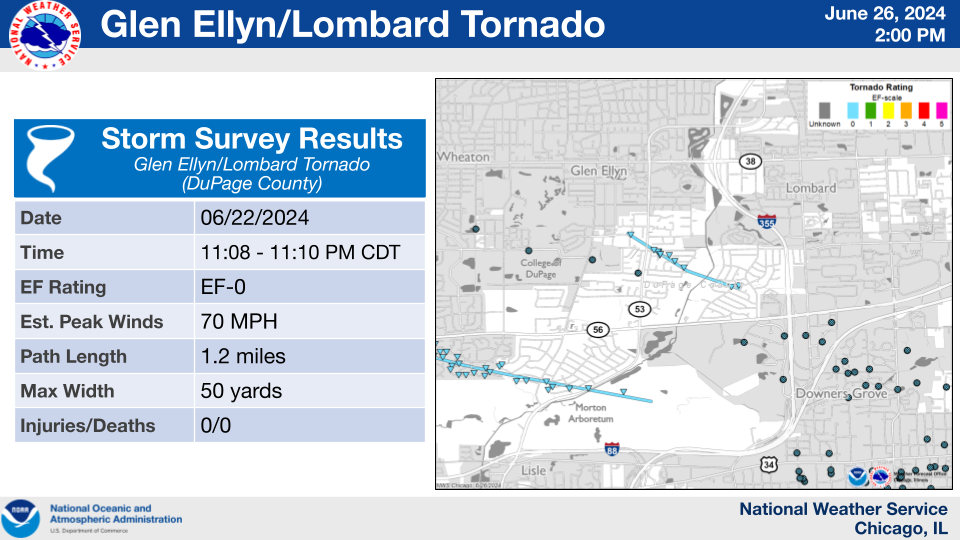
1108 PM Tornado 2 SSE Glen Ellyn 41.85N 88.06W
06/22/2024 DuPage IL NWS Storm Survey
Delayed report from 6/22. An NWS storm
survey confirmed that an EF-0 tornado with
estimated peak winds of 70 mph, path length
of 1.2 miles, and maximum width of 50 yards
produced a narrow corridor of minor damage
to trees and residences in the Butterfield
West subdivision near Glen Ellyn and
Lombard.
1109 PM Tstm Wnd Dmg 3 NNW Downers Grove 41.83N 88.03W
06/22/2024 DuPage IL Public
Several large branches downed and also 2
large old Willow trees uprooted.
1111 PM Tstm Wnd Dmg 1 N Downers Grove 41.81N 88.01W
06/22/2024 DuPage IL NWS Storm Survey
Delayed report from 6/22. An NWS storm
survey confirmed that widespread tree damage
across the north side of Downers Grove was
caused primarily by strong straight-line
winds. A church steeple was also bent.
1112 PM Marine Tstm Wind 1 NE Montrose Harbor 41.97N 87.63W
06/22/2024 M39 MPH LMZ741 IL Mesonet
Mesonet station XMTB Montrose Beach Light.
1113 PM Tstm Wnd Dmg 1 NNW Westmont 41.81N 87.99W
06/22/2024 DuPage IL Public
Large tree uprooted.
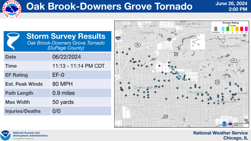
1113 PM Tornado 2 NNE Downers Grove 41.82N 87.99W
06/22/2024 DuPage IL NWS Storm Survey
Delayed report from 6/22. An NWS storm
survey confirmed that an EF-0 tornado with
estimated peak winds of 80 mph, path length
of 0.9 miles, and maximum width of 50 yards
touched down on the far southwest side of
Oak Brook and tracked southeast into Downers
Grove, damaging several trees and causing
minor damage to a few residences.
1114 PM Tstm Wnd Dmg 1 N Westmont 41.80N 87.98W
06/22/2024 DuPage IL NWS Storm Survey
Delayed report from 6/22. An NWS storm
survey confirmed that widespread tree damage
across the north side of Westmont was caused
by strong straight-line winds.
1114 PM Tstm Wnd Gst 1 N Westmont 41.81N 87.98W
06/22/2024 M61 MPH DuPage IL Public
Davis personal weather station.
1115 PM Tstm Wnd Dmg Clarendon Hills 41.80N 87.95W
06/22/2024 DuPage IL NWS Storm Survey
Delayed report from 6/22. An NWS storm
survey confirmed that widespread tree damage
in Clarendon Hills was caused by strong
straight-line winds.
1116 PM Tstm Wnd Dmg 1 NW Indian Head Park 41.78N 87.91W
06/22/2024 Cook IL Public
Large branches down, approximated 12tree
snapped diameter tree snapped at the base in
Katherine Legge Memorial Park.
1117 PM Tstm Wnd Dmg Hinsdale 41.80N 87.93W
06/22/2024 DuPage IL NWS Storm Survey
Delayed report from 6/22. An NWS storm
survey confirmed that widespread tree damage
in Hinsdale was caused by strong
straight-line winds.
1120 PM Flash Flood 2 E Green Oaks 42.30N 87.88W
06/22/2024 Lake IL Public
Route 41 closed northbound between Rte. 60
in Lake Forest and Washington St. in
Waukegan due to areas of flooding.
1124 PM Tstm Wnd Dmg 1 NNW Boulder Hill 41.72N 88.34W
06/22/2024 Kendall IL Emergency Mngr
Report of a tree down blocking the road at
Briarcliff and Fernwood Roads in Boulder
Hill. Time estimated by radar.
1124 PM Tstm Wnd Dmg 2 NW Bolingbrook 41.72N 88.10W
06/22/2024 Will IL NWS Employee
20 foot long, 6 inch diameter tree branch
blocking west bound Royce Road. Time
approximated by radar.
1138 PM Tstm Wnd Gst 3 NE Navy Pier 41.92N 87.57W
06/22/2024 M40 MPH LMZ741 IL Mesonet
Peak wind gust of 35 kts. Mesonet station
CHII2 Harrison-Dever Crib.
1145 PM Flash Flood 1 S South Lawndale - Ch 41.83N 87.71W
06/22/2024 Cook IL Broadcast Media
Flooding all lanes of the inbound and
outbound Stevenson flooded between Pulaski
and Kedzie.
1145 PM Flash Flood 1 SSW Washington Park - 41.78N 87.63W
06/22/2024 Cook IL Law Enforcement
Viaduct in the 6300 block of south State St
is flooded and impassable.
1145 PM Tstm Wnd Dmg 1 WSW Plainfield 41.60N 88.23W
06/22/2024 Will IL Public
Report of a bigger limb that came down and
stuck in lower branches of the tree. Time
Approximated by radar.
1159 PM Flash Flood Island Lake 42.27N 88.20W
06/22/2024 Lake IL Amateur Radio
Delayed report from 6/22. Culverts
overflowed and low-lying areas were flooded
in Island Lake. Personal weather station
measured 4.40 inches of rainfall.
|
Tornadoes
|
Downloadable KMZ File with All Damage Survey Data Downloadable Shapefile with All Damage Survey Data
Below is a summary of all of the tornadoes in the NWS Chicago forecast area from this severe weather event. An interactive map with all of this information can be found on our Damage Assessment Toolkit Viewer website (to see the data from this event, make sure that the date range in the top right corner includes this event's date). Instructions for how to download survey data (KMZ files and shapefiles) are available here. |
1.) Elburn EF-0
|
(click on image to enlarge) |
|
Summary: An EF0 tornado started just west of downtown Elburn, south of the railroad tracks, where concentrated tree damage was found. Crop damage was noted in the vicinity of Anderson Road. Pockets of tree damage continued to just east of Pauley Road just to the west of La Fox.) |
2.) Wheaton EF-0
|
(click on image to enlarge) |
|
Summary: This tornado began near Route 59 in the Blackwell Forest Preserve. It then tracked towards Wheaton-Warrenville South High School and into the south side of Wheaton before lifting soon after it entered the Morton Arboretum. The tornado primarily caused tree damage along its nearly 8-mile long path, though it also caused some minor damage to signs at a shopping center. |
3.) Glen Ellyn/Lombard EF-0
|
(click on image to enlarge) |
|
Summary: This brief tornado produced a narrow corridor of minor damage to trees and residences in the Butterfield West subdivision before lifting just northeast of the Butterfield Elementary School. Damage was consistent with EF0 winds near 70 mph. |
4.) Oak Brook - Downers Grove EF-0
|
(click on image to enlarge) |
|
Summary: A brief tornado touched down near Fairview Avenue and 38th Street in Oak Brook. The first damage was noted along Ridgewood Court and 38th Street, where multiple trees had large branches broken. The tornado moved generally to the southeast, entering Downers Grove near Cumnor Road and 39th Street, where damage was noted to numerous trees. Minor damage was also noted to the cupola of a nearby residence. The tornado moved through the Longmeadow neighborhood, continuing to damage numerous trees. In some areas, the most significant tree damage was noted just above roof level. The tornado slightly intensified near 41st Street and Williams Street, where a few homes had minor roofing damage and numerous trees had large branches broken. Debris from damaged fences was blown in a somewhat convergent pattern toward 41st Street on opposite sides of the street. The tornado appeared to dissipate just southeast of this area as it approached Westmont. The peak wind of this tornado was estimated at 80 mph. This tornado occurred on the northern edge of a much larger area of tree damage associated with straight-line winds. |
The Enhanced Fujita (EF) Scale classifies tornadoes into the following categories:
| EF0 Weak 65-85 mph |
EF1 Moderate 86-110 mph |
EF2 Significant 111-135 mph |
EF3 Severe 136-165 mph |
EF4 Extreme 166-200 mph |
EF5 Catastrophic 200+ mph |
 |
|||||
When a tornado is known to have occurred but does not cause damage to any qualified damage indicators, or if the only damage is located in an area that is inaccessible to NWS storm survey personnel, then a tornado may be assigned the EF-Unknown (EF-U) rating.
Straight-Line Winds
1.) Southeast DuPage County
|
(click on image to enlarge) |
|
Summary: A corridor of straight-line wind damage occurred in the Glen Ellyn, Downers Grove, Oak Brook, Westmont, and Clarendon Hills areas. Straight-line winds initially occurred along two corridors approximately one half mile in width, the northern area beginning just south of Glen Ellyn and the southern area beginning south of Morton Arboretum. To the east, these areas of wind damage merged in northeastern Downers Grove and reached a peak width of approximately 1.5 miles. As the winds moved to the east, the width narrowed slightly as peak winds decreased, with straight line wind damage appearing to end near Clarendon Hills. Most damage was confined to trees, including widespread breaking of twigs and small branches with isolated large branches broken, consistent with peak wind gusts up to 60 mph. A few smaller areas experienced more significant wind damage, including a large uprooted tree and numerous large branches broken in the Orchard Brook neighborhood of Downers Grove, damage to a church and numerous large branches broken near Downers Grove North High School, damage to utility poles and large branches broken in the Fairview Avenue subdivision of Downers Grove, and damage to a utility pole and large branches broken in the Blackhawk Heights subdivision of Westmont and also nearby western Clarendon Hills. Damage in each of these isolated, narrow corridors was consistent with peak wind gusts up to 70-75 mph. Embedded in the northern edge of this corridor of straight-line winds was a brief, narrow tornado that impacted areas near the edges of Oak Brook, Downers Grove, and Westmont. However, the overwhelming majority of damage in the surveyed area was due to straight-line winds. |
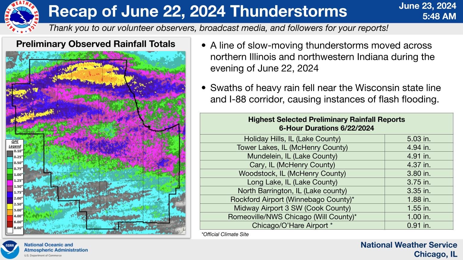
Rainfall
|
|
Public Information Statement National Weather Service Chicago IL 1258 PM CDT Sun Jun 23 2024 ...PRECIPITATION REPORTS... Location Amount Time/Date Provider ...Illinois... ...Boone County... Belvidere 3.80 in 1247 PM 06/23 Broadcast Media Capron 3.03 in 0700 AM 06/23 COCORAHS Poplar Grove 1.3 WSW 2.59 in 0613 AM 06/23 COCORAHS ...Kane County... Kaneville 3 NNW 2.86 in 0700 AM 06/23 COCORAHS Batavia 1 NW 2.52 in 0700 AM 06/23 COCORAHS ...Lake County... 1 N Tower Lakes 4.94 in 1230 AM 06/23 Mesonet 1 W Mundelein 4.91 in 1203 AM 06/23 Mesonet 1 SE Wauconda 4.75 in 1058 PM 06/22 Emergency Mngr 2 WSW Mundelein 4.37 in 1202 AM 06/23 Mesonet Hawthorn Woods 4.33 in 1149 PM 06/22 CWOP Mundelein 1 NNE 3.80 in 0800 AM 06/23 COCORAHS Volo 0.9 S 3.79 in 0700 AM 06/23 COCORAHS 2 SW Long Lake 3.75 in 1230 AM 06/23 Mesonet Lake Bluff 2 W 3.69 in 0600 AM 06/23 COCORAHS Libertyville 3.66 in 0645 AM 06/23 COCORAHS 1 S Round Lake 3.54 in 0700 AM 06/23 COCORAHS Deerfield - W. Fork N. Br. C 3.41 in 1240 PM 06/23 Hydro 1 NE North Barrington 3.35 in 1144 PM 06/22 AWS Lincolnshire 1 NNW 3.28 in 0800 AM 06/23 COCORAHS Lake Zurich 1 N 3.23 in 0600 AM 06/23 COCORAHS Deerfield - W. Fork N. Br. C 3.17 in 1140 PM 06/22 Hydro Lake Forest 3.17 in 1145 PM 06/22 CWOP Riverwoods 1 NE 3.10 in 0700 AM 06/23 COCORAHS Lake Bluff 2.96 in 1236 PM 06/23 CWOP Grayslake 1 WNW 2.85 in 0600 AM 06/23 COCORAHS Buffalo Grove 2 N 2.79 in 0700 AM 06/23 COCORAHS ...McHenry County... 1 SSE Holiday Hills 5.03 in 1230 AM 06/23 Mesonet Union 5.00 in 0621 AM 06/23 Public Woodstock 4.69 in 1230 AM 06/23 CWOP Cary 4.37 in 1149 PM 06/22 CWOP 1 NE Holiday Hills 4.35 in 1156 PM 06/22 Mesonet 2 S McHenry 4.24 in 1158 PM 06/22 Mesonet Woodstock 3.80 in 1145 PM 06/22 CWOP 2 SW Bull Valley 3.78 in 1230 AM 06/23 Mesonet 2 ENE Holiday Hills 3.76 in 1230 AM 06/23 Mesonet Crystal Lake 4 NW 3.73 in 0700 AM 06/23 COOP McHenry 1 ENE 3.45 in 0930 AM 06/23 COCORAHS Cary 3.35 in 0700 AM 06/23 COCORAHS Trout Valley 3.10 in 0700 AM 06/23 COCORAHS Lakemoor 2 NW 3.06 in 0630 AM 06/23 COCORAHS Crystal Lake 3.00 in 1121 PM 06/22 CWOP Lakewood 0.1 ENE 2.96 in 0700 AM 06/23 COCORAHS Observations are collected from a variety of sources with varying equipment and exposures. We thank all volunteer weather observers for their dedication. Not all data listed are considered official. $$ |
 |
Media use of NWS Web News Stories is encouraged! Please acknowledge the NWS as the source of any news information accessed from this site. Additional recaps can be found on the NWS Chicago Past Events Page |
|


.png)

.png)
