A significant heat wave continues for the Rockies, Northern Plains, and Great Lakes into the Mid-Atlantic, peaking in intensity through midweek and lingering across parts of the Northern Plains and Midwest until this weekend. Excessive rainfall my bring life-threatening and locally catastrophic flash and urban flooding across portions of southwestern Texas through early Friday. Read More >
|
|
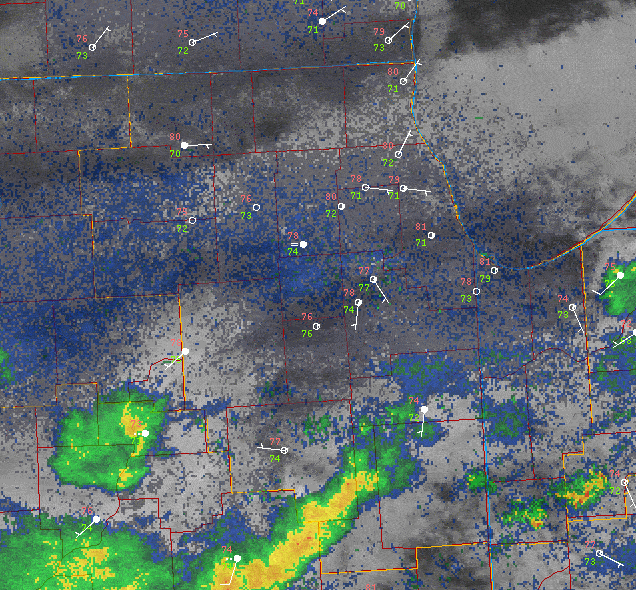
(Click to enlarge loop) Radar and satellite loop from 10 AM to 2 PM on July 25th. Loop courtesy of the College of DuPage |
Overview
For detailed information about the rainfall of July 25, see The Summer 2025 Flash Flood Events in Northern Illinois and Northwestern Indiana, a NWS Technical Paper which details the rainfall, flooding, and impacts, associated with multiple summer 2025 extreme rainfall events.
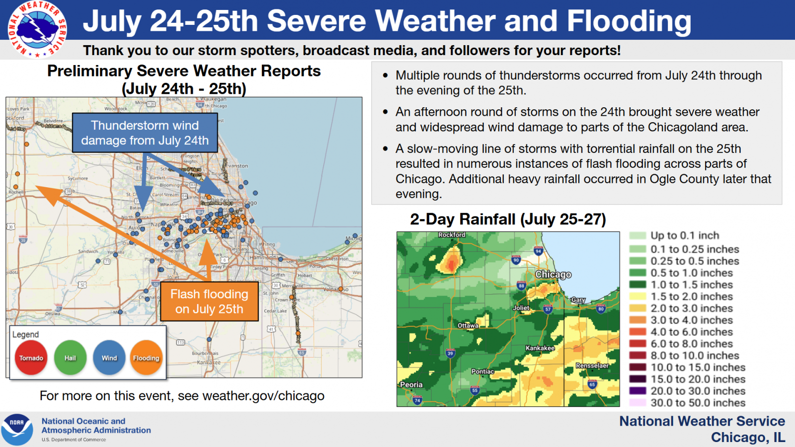
July 24th Severe Weather
|
Preliminary Storm Report Map |
Preliminary Local Storm Report...Summary National Weather Service Chicago IL 321 PM CDT Sat Jul 26 2025 ..TIME... ...EVENT... ...CITY LOCATION... ...LAT.LON... ..DATE... ....MAG.... ..COUNTY LOCATION..ST.. ...SOURCE.... ..REMARKS.. 0224 PM Tstm Wnd Dmg 1 N Oswego 41.69N 88.35W 07/24/2025 Kendall IL Trained Spotter Large tree branches and limbs downed in Oswego. Time estimated from radar. 0224 PM Tstm Wnd Dmg Millbrook 41.60N 88.56W 07/24/2025 Kendall IL Public Videos show two downed trees in Millbrook. Time estimated from radar. 0225 PM Tstm Wnd Dmg 1 E Montgomery 41.73N 88.32W 07/24/2025 Kane IL Emergency Mngr Numerous wires down. 0226 PM Tstm Wnd Dmg Montgomery 41.73N 88.34W 07/24/2025 Kane IL Public Photo shared of a downed large tree limb that crushed the hood of a sedan. Time estimated from radar. 0226 PM Tstm Wnd Gst 2 WSW Montgomery 41.72N 88.38W 07/24/2025 E60 MPH Kane IL Trained Spotter 0228 PM Tstm Wnd Dmg 2 ESE Aurora 41.75N 88.28W 07/24/2025 Kane IL Emergency Mngr Multiple reports of trees and wires downed across Aurora. 0228 PM Tstm Wnd Dmg 1 ENE North Aurora 41.82N 88.31W 07/24/2025 Kane IL Law Enforcement Multiple trees downed on the east side of North Aurora. Time estimated from radar. 0228 PM Tstm Wnd Dmg 2 ESE North Aurora 41.79N 88.30W 07/24/2025 Kane IL Emergency Mngr Tree downed onto a house. Time estimated from radar. 0235 PM Tstm Wnd Dmg 1 S Yorkville 41.63N 88.45W 07/24/2025 Kendall IL Public Updates previous tstm wnd dmg report from 1 S Yorkville. Multiple public reports of downed trees on the south side of Yorkville. Time estimated from radar. 0237 PM Tstm Wnd Dmg 1 S Naperville 41.75N 88.15W 07/24/2025 DuPage IL Public Multiple public reports of downed trees and large tree limbs on the south side of Naperville. Time estimated from radar. 0238 PM Tstm Wnd Dmg 3 WNW Bolingbrook 41.73N 88.12W 07/24/2025 Will IL NWS Employee Photo showed a large oak tree down in front yard. 0238 PM Tstm Wnd Dmg 2 ESE Naperville 41.76N 88.11W 07/24/2025 DuPage IL NWS Employee Trees and wires down near Naper Blvd and Collingwood Drive. 0238 PM Tstm Wnd Dmg 1 NNW Naperville 41.78N 88.15W 07/24/2025 DuPage IL Public Numerous trees and wires down in the vicinity. Relayed via the city of Naperville. 0240 PM Flood 3 SSE Naperville 41.74N 88.12W 07/24/2025 DuPage IL NWS Employee Several inches of standing water along and near Naper Boulevard. 0243 PM Tstm Wnd Dmg 3 NW Romeoville 41.68N 88.13W 07/24/2025 Will IL NWS Employee Power poles snapped. 0244 PM Tstm Wnd Dmg 1 SE Woodridge 41.75N 88.04W 07/24/2025 DuPage IL Law Enforcement Power lines and large tree branches downed in Woodridge. Damage to gutters and siding reported as well. 0244 PM Tstm Wnd Dmg Woodridge 41.76N 88.04W 07/24/2025 DuPage IL NWS Employee Estimated 65 mph wind gusts. Numerous 3 to 6 inch diameter tree limbs down. 0244 PM Tstm Wnd Dmg 2 SSE Bolingbrook 41.67N 88.06W 07/24/2025 Will IL Emergency Mngr Corrects and combines previous tstm wnd dmg reports from 2 SSE Bolingbrook. A large, rotting tree was snapped a few feet up at the White Fence Farm Restaurant, landing on a fence and onto Joliet Road. Another nearby tree also had a large limb snapped off. Time estimated from radar. 0244 PM Tstm Wnd Dmg 1 E Bolingbrook 41.70N 88.05W 07/24/2025 Will IL Public Tree branch greater than 6 inches in diameter downed in a front yard on North Pinecrest Road. Time estimated from radar. 0245 PM Tstm Wnd Dmg 2 SW Darien 41.73N 88.01W 07/24/2025 DuPage IL Amateur Radio 12 inch diameter tree limb downed at Oldfield Road and Lemont Road. 0245 PM Tstm Wnd Dmg Lemont 41.67N 88.00W 07/24/2025 Cook IL Emergency Mngr Wires down and tree down in the road. 0246 PM Tstm Wnd Dmg 1 S Lisle 41.79N 88.07W 07/24/2025 DuPage IL Public Video received showing numerous tree branches of various sizes down near the intersection of Short Street and Main Street in Lisle. 0246 PM Tstm Wnd Gst 1 SE Lisle 41.79N 88.07W 07/24/2025 E80 MPH DuPage IL NWS Employee Based on an NWS damage survey, a microburst with peak wind estimated near 80 mph started near Lisle High School at the intersection of Ohio Court and Short streets, and continued eastward along Riedy Road, ending near Interstate 355. Damage within the path consisted of downed and uprooted trees, including several that fell on homes. One tree branch struck and broke a window at a house on Short Street, while others fell on fences and at least one porch near the intersection of Riedy Road and Kingston Avenue. All damage was downed facing the northeasterly direction, and aligned with a signature of straight line winds indicated by terminal Doppler radar. 0246 PM Tstm Wnd Dmg 1 E Downers Grove 41.79N 88.00W 07/24/2025 DuPage IL Trained Spotter Photo shared of a large tree limb snapped. Time estimated from radar. 0248 PM Tstm Wnd Dmg 1 N Darien 41.76N 87.97W 07/24/2025 DuPage IL Local Official Photo shared of rotted tree downed onto street. Time estimated from radar. 0248 PM Tstm Wnd Dmg Westmont 41.79N 87.98W 07/24/2025 DuPage IL Public Photo shared on social media showing a downed tree in Westmont. Time estimated from radar. 0249 PM Tstm Wnd Dmg 1 WNW Willowbrook 41.77N 87.95W 07/24/2025 DuPage IL Public Photo shared on social media of approximately 3 inch diameter tree branches downed at Route 83 and 63rd Street. Time estimated from radar. 0252 PM Tstm Wnd Dmg Hinsdale 41.80N 87.93W 07/24/2025 DuPage IL Public Photos submitted of trees with large branches snapped. Time estimated by radar. 0252 PM Tstm Wnd Dmg Indian Head Park 41.77N 87.90W 07/24/2025 Cook IL Public Photo shared on social media of a large tree limb snapped in Indian Head Park. Time estimated from radar. 0254 PM Tstm Wnd Dmg 1 SE La Grange 41.80N 87.86W 07/24/2025 Cook IL Public One foot diameter tree limb down onto a power line. 0254 PM Tstm Wnd Dmg 1 NW Countryside 41.79N 87.89W 07/24/2025 Cook IL Public Large tree branches downed. 0255 PM Tstm Wnd Dmg 1 WNW Justice 41.75N 87.85W 07/24/2025 Cook IL Public Photo shared on social media showing a large tree limb downed onto a mobile home in Justice, caving its roof in by about a foot. Trees and power lines were downed elsewhere in Justice. Time estimated from radar. 0255 PM Tstm Wnd Dmg La Grange 41.81N 87.87W 07/24/2025 Cook IL Public Multiple reports of large tree limbs downed in La Grange. Time estimated from radar. 0255 PM Tstm Wnd Dmg 1 SE Burr Ridge 41.74N 87.89W 07/24/2025 Cook IL Public Tree blown down. Time estimated from radar. 0256 PM Tstm Wnd Dmg Brookfield 41.82N 87.85W 07/24/2025 Cook IL Public Photo shared on social media showing a tree downed onto a road in Brookfield. Time estimated from radar. 0258 PM Tstm Wnd Dmg Bridgeview 41.75N 87.80W 07/24/2025 Cook IL Public Photo shared on social media of tree downed onto wires in Bridgeview. Time estimated from radar. 0258 PM Tstm Wnd Dmg Berwyn 41.84N 87.79W 07/24/2025 Cook IL Public Multiple 12 inch diameter trees snapped. 0258 PM Tstm Wnd Dmg 1 SE Riverside 41.82N 87.81W 07/24/2025 Cook IL Broadcast Media Corrects time of previous tstm wnd dmg report from 1 SE Riverside. Local broadcast media reports that a brick wall partially collapsed on a building near the intersection of Ogden Ave and Powell Ave in Lyons. No injuries were reported. 0259 PM Tstm Wnd Dmg Stickney 41.82N 87.79W 07/24/2025 Cook IL Public Photo shared on social media showing a large tree limb downed in Stickney. Time estimated from radar. 0259 PM Tstm Wnd Dmg 2 S Berwyn 41.83N 87.79W 07/24/2025 Cook IL Broadcast Media Power lines next to a BP gas station were downed, causing two main gas lines to ignite. The resulting fire spread to a nearby tree before the gas lines eventually exploded. The explosion caused the adjacent gas station building to collapse and also shattered the windows of nearby residences and businesses. 0300 PM Tstm Wnd Dmg 1 ENE Morgan Park - Chi 41.70N 87.65W 07/24/2025 Cook IL Broadcast Media *** 1 INJ *** Corrects previous report from 1 ENE Morgan Park - Chicago. Local broadcast media reports that a person suffered minor injuries after a large tree fell on their house near 109th and Throop streets in the Morgan Park neighborhood of Chicago. 0300 PM Tstm Wnd Gst 1 W Oak Lawn 41.72N 87.77W 07/24/2025 M72 MPH Cook IL Public 0300 PM Tstm Wnd Dmg Burbank 41.75N 87.77W 07/24/2025 Cook IL Public Tree downed onto a garage in Burbank. 0300 PM Tstm Wnd Gst 3.0 SW Midway Airport 41.74N 87.78W 07/24/2025 M70 MPH Cook IL CO-OP Observer 0301 PM Tstm Wnd Dmg 1 N Oak Lawn 41.73N 87.75W 07/24/2025 Cook IL Public Multiple public reports of downed trees on the north side of Oak Lawn. Time estimated from radar. 0301 PM Tstm Wnd Gst Oak Lawn 41.72N 87.75W 07/24/2025 M68 MPH Cook IL Public 2 inch diameter tree limbs also broken. 0302 PM Tstm Wnd Gst Midway Airport 41.79N 87.76W 07/24/2025 M64 MPH Cook IL ASOS Measured at the Midway ASOS. 0303 PM Tstm Wnd Dmg South Lawndale - Chicag 41.84N 87.72W 07/24/2025 Cook IL Public Photo shared on social media showing a large tree limb downed onto Lawndale Avenue near 31st Street in the Little Village neighborhood of Chicago. Time estimated from radar. 0304 PM Tstm Wnd Dmg 1 ESE Chicago Lawn 41.76N 87.67W 07/24/2025 Cook IL Broadcast Media Tree down on house. 0305 PM Tstm Wnd Dmg 1 NW Lakeview - Chicago 41.95N 87.66W 07/24/2025 Cook IL Public Photo shared on social media showing a tree downed onto a street in the Lakeview community area of Chicago. Time estimated from radar. 0308 PM Tstm Wnd Gst 1 NE Montrose Harbor 41.97N 87.63W 07/24/2025 M59 MPH LMZ741 IL Mesonet Peak gust at the Montrose Beach Light. 0310 PM Tstm Wnd Dmg 1 WSW Plainfield 41.60N 88.22W 07/24/2025 Will IL Public Multiple public reports of downed trees and large tree limbs in Plainfield. Time estimated from radar. 0312 PM Tstm Wnd Gst 1 SSE Hyde Park - Chica 41.79N 87.59W 07/24/2025 M68 MPH Cook IL Public Measured at a personal weather station. 0312 PM Tstm Wnd Gst 1 WSW Northerly Island 41.86N 87.62W 07/24/2025 M56 MPH Cook IL Mesonet Measured on a personal weather station. 0320 PM Flash Flood 1 E Stone Park 41.91N 87.87W 07/24/2025 Cook IL Public Photos shared on social media showing two cars submerged halfway underwater in an underpass on North Avenue in Melrose Park. 0320 PM Flood Melrose Park 41.90N 87.86W 07/24/2025 Cook IL Public Photo shared on social media showing several inches of standing water on a street in Melrose Park. A separate report of minor basement flooding was also received from Melrose Park. 0321 PM Tstm Wnd Dmg Morris 41.36N 88.42W 07/24/2025 Grundy IL Public Multiple public reports of downed trees and large tree limbs in and near Morris. Time estimated from radar. 0322 PM Marine Tstm Wind 3 NE Navy Pier 41.92N 87.57W 07/24/2025 M51 MPH LMZ741 IL C-Man Station Measured at the Harrison-Dever Crib. 0325 PM Tstm Wnd Dmg 1 SW Crystal Lawns 41.56N 88.17W 07/24/2025 Will IL Public Multiple public reports of downed trees and large tree limbs on the northwest side of Joliet. Time estimated from radar. 0326 PM Tstm Wnd Dmg 1 SW Crystal Lawns 41.56N 88.16W 07/24/2025 Will IL Public Fence partially blown down and two fence posts snapped. 0334 PM Tstm Wnd Gst Gary Airport 41.61N 87.41W 07/24/2025 M63 MPH Lake IN AWOS GYY AWOS. 0355 PM Tstm Wnd Dmg 1 SW Channahon 41.42N 88.25W 07/24/2025 Will IL Public Photo shared on social media showing a snapped tree in Channahon. Time estimated from radar. 0358 PM Marine Tstm Wind 3 NE Beverly Shores 41.72N 86.94W 07/24/2025 M56 MPH LMZ745 IN C-Man Station Measured at the Michigan City GLERL site. 0400 PM Tstm Wnd Gst 1 WSW Beverly Shores 41.69N 86.99W 07/24/2025 M58 MPH Porter IN Mesonet Measured on a personal weather station. 0400 PM Tstm Wnd Dmg Minooka 41.46N 88.26W 07/24/2025 Grundy IL Public Photo shared on social media showing a large tree limb downed onto a house in Minooka. Another photo was shared showing a snapped tree elsewhere in Minooka. Time estimated from radar. 0503 PM Tstm Wnd Dmg Dwight 41.09N 88.43W 07/24/2025 Livingston IL Public Photo shared on social media showing a large tree limb snapped in Dwight. Time estimated from radar. 0554 PM Tstm Wnd Dmg 2 SSW Manteno 41.23N 87.86W 07/24/2025 Kankakee IL Public Photo shared on social media showing a tree downed onto Frontage Road near Manteno. Time estimated from radar. && $$ |
July 25th Heavy Rain and Flash Flooding
 |
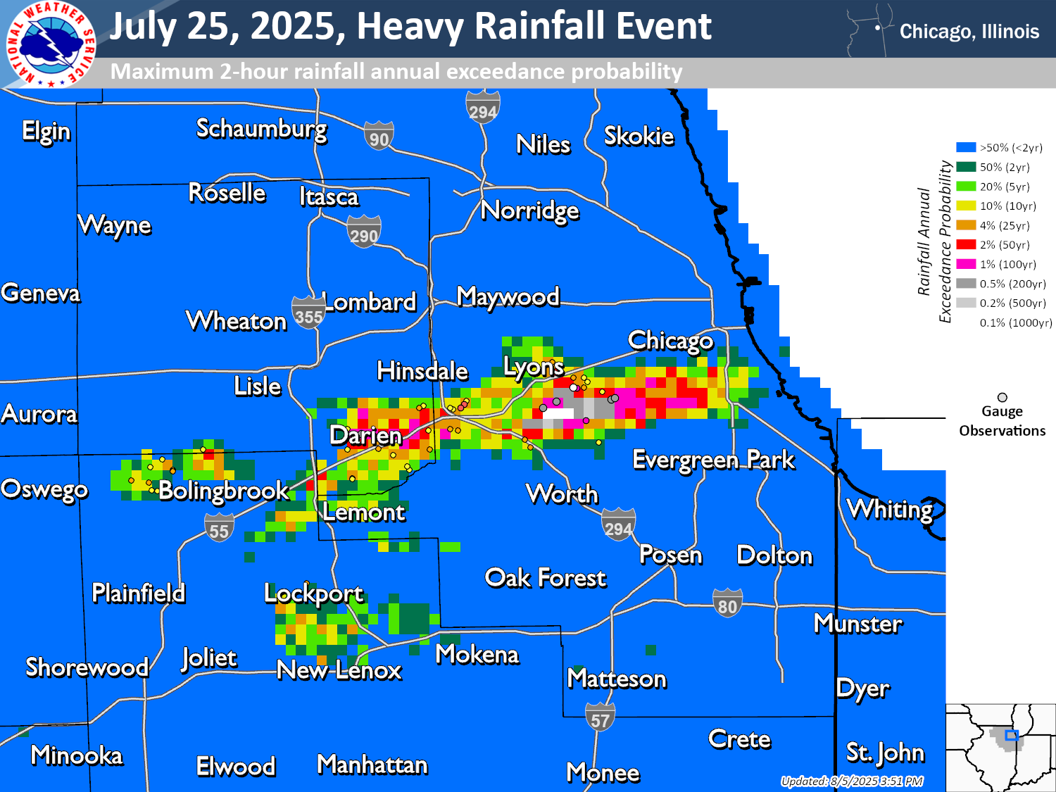 |
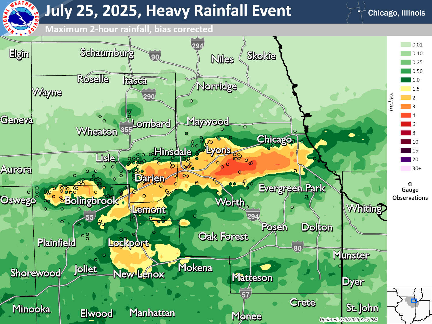
| Maximum 2-hour rainfall | Maximum 2-hour rainfall annual exceedance probability |
Preliminary Local Storm Report...Summary
National Weather Service Chicago IL
433 PM CDT Sat Jul 26 2025

..TIME...   ...EVENT...      ...CITY LOCATION...     ...LAT.LON...
..DATE...   ....MAG....      ..COUNTY LOCATION..ST.. ...SOURCE....
            ..REMARKS..

0930 AM     Funnel Cloud     Serena                  41.48N 88.74W
07/25/2025                   La Salle           IL   Emergency Mngr

            Photos shared show a well developed funnel
            cloud extending two thirds of the way to the
            ground near Serena.

1010 AM     Funnel Cloud     2 W Dayton              41.38N 88.84W
07/25/2025                   La Salle           IL   Law Enforcement

            Numerous reports of funnel clouds relayed by
            state trooper and law enforcement.

1142 AM     Flash Flood      3 SSE Naperville        41.73N 88.13W
07/25/2025                   DuPage             IL   Public

            Photos showed on social media showed
            submerged roadways (at least 6 inches of
            water) in the vicinity of 87th street and
            South Washington.

1205 PM     Flood            2 SE Naperville         41.75N 88.12W
07/25/2025                   DuPage             IL   Public

            Photo showing a few inches of standing water
            at the Market Meadows Shopping Center
            parking lot.

1210 PM     Flash Flood      1 SSW Washington Park - 41.78N 87.63W
07/25/2025                   Cook               IL   NWS Employee

            Reports of underpass on South State street
            completely filled with water. Vehicle
            extrication in progress.

1210 PM     Flood            4 SSW Naperville        41.71N 88.17W
07/25/2025                   Will               IL   Public

            Video shared on social media of neighborhood
            roads in the vicinity of 95th Street and
            Plainfield-Naperville Road submerged in
            standing water.

1215 PM     Flash Flood      Chicago Lawn            41.77N 87.70W
07/25/2025                   Cook               IL   Public

            Numerous reports indicating widespread
            flooding of basements in the Chicago Lawn
            community area of Chicago. Relayed via
            Chicago311.

1215 PM     Flash Flood      1 E Midway Airport      41.78N 87.72W
07/25/2025                   Cook               IL   Public

            Numerous reports indicating widespread
            flooding of basements in the West Lawn and
            West Elsdon community areas of Chicago.
            Relayed via Chicago311.

1215 PM     Flash Flood      1 SW Bridgeview         41.74N 87.82W
07/25/2025                   Cook               IL   Emergency Mngr

            Flood waters were waist-high along
            neighborhood streets from 79th street to
            83rd street. In addition, 6 to 18 inches of
            water was on roadways from 71th street to
            84th street just east of Harlem Ave. There
            were over a dozen water rescues across
            Bridgeview during the flash flood.

1220 PM     Flash Flood      1 SW Darien             41.74N 87.99W
07/25/2025                   DuPage             IL   Broadcast Media

            Multiple rooms were flooded inside the
            Darien Municipal Center.

1220 PM     Flash Flood      1 S Darien              41.74N 87.97W
07/25/2025                   DuPage             IL   Public

            Multiple public reports of flooding in
            Darien. Cars got stuck in several inches of
            water on Cass Avenue, eventually leading to
            the roads closure. Knee-deep water reported
            in parking lots and several side streets
            flooded as well.

1230 PM     Flash Flood      1 SSW Willowbrook       41.76N 87.94W
07/25/2025                   DuPage             IL   Public

            Updates previous flash flood report from 1
            SSW Willowbrook. Parking lots and roads at
            and near the intersection of Route 83 and
            Plainfield Road on the south side of
            Willowbrook flooded with several inches of
            water. Basement flooding also reported in
            adjacent neighborhood.

1230 PM     Flash Flood      1 ESE Archer Hts. - Chi 41.81N 87.71W
07/25/2025                   Cook               IL   Broadcast Media

            Viaduct flooded at Archer Avenue and 47th
            Street.

1230 PM     Flood            Indian Head Park        41.77N 87.90W
07/25/2025                   Cook               IL   Public

            Video shared on social media of a few inches
            of standing water on a road in Indian Head
            Park.

1230 PM     Flash Flood      1 WSW Gage Park - Chica 41.79N 87.71W
07/25/2025                   Cook               IL   Public

            Photo shared on social media showing several
            inches of water flooding the 58th Street
            underpass at Central Park Avenue.

1230 PM     Flash Flood      Gage Park - Chicago     41.79N 87.70W
07/25/2025                   Cook               IL   Public

            Multiple public reports of basement flooding
            in and near the Gage Park community area of
            Chicago.

1231 PM     Flash Flood      New City - Chicago      41.81N 87.65W
07/25/2025                   Cook               IL   911 Call Center

            Corrects previous flash flood report from
            New City - Chicago. 2 to 3 feet of water
            reported on 47th street between South
            Halsted Street and South Morgan Street.

1231 PM     Flash Flood      1 ESE New City - Chicag 41.80N 87.64W
07/25/2025                   Cook               IL   911 Call Center

            Corrects previous flash flood report from 1
            ESE New City - Chicago. Viaduct completely
            flooded.

1240 PM     Flood            Countryside             41.78N 87.88W
07/25/2025                   Cook               IL   Public

            Videos and photos shared on social media
            show a few inches of standing water on
            multiple roads in Countryside.

1240 PM     Flash Flood      Summit                  41.79N 87.81W
07/25/2025                   Cook               IL   Trained Spotter

            Photos and videos shared on social media
            showing multiple streets flooded with
            several inches of water in Summit.

1240 PM     Flash Flood      1 NNE Bedford Park      41.78N 87.79W
07/25/2025                   Cook               IL   Trained Spotter

            Photos and videos shared on social media
            showing multiple streets flooded with
            several inches of water in the Clearing and
            Garfield Ridge community areas of Chicago.
            Multiple public reports of flooded basements
            in the area.

1245 PM     Flash Flood      1 WSW Burr Ridge        41.74N 87.94W
07/25/2025                   DuPage             IL   Emergency Mngr

            Video shared by EM official depicts 6 to 12
            inches of water on southbound lanes of
            Interstate 55 near IL 83.

1245 PM     Flash Flood      Justice                 41.75N 87.84W
07/25/2025                   Cook               IL   Public

            Multiple public reports of flooding in
            Justice. At least one car got stuck in flood
            waters, and multiple streets were flooded
            with several inches of water.

1257 PM     Flash Flood      1 ENE Gage Park - Chica 41.80N 87.68W
07/25/2025                   Cook               IL   911 Call Center

            Person trapped in car in flooded viaduct.
            Police were called to perform a rescue.

1258 PM     Flash Flood      1 N Gage Park - Chicago 41.80N 87.69W
07/25/2025                   Cook               IL   911 Call Center

            Person trapped in vehicle in flooded
            viaduct. The vehicle was towed out of the
            floodwaters.

0100 PM     Flash Flood      1 SSE Midway Airport    41.76N 87.74W
07/25/2025                   Cook               IL   Public

            Photo shared on social media showing several
            inches of water covering the Target parking
            lot in Bedford Park. A few inches of water
            also reported on Cicero Avenue between 72nd
            Street and 79th Street.

0100 PM     Flash Flood      1 SE Gage Park - Chicag 41.79N 87.68W
07/25/2025                   Cook               IL   911 Call Center

            Report of a flooded viaduct.

0100 PM     Rain             1 SSW Darien            41.74N 87.98W
07/25/2025  M4.72 Inch       DuPage             IL   Public

            Personal weather station measured 4.72
            inches of rain between 11:00 AM and 1:00 PM.

0100 PM     Flash Flood      1 W Bedford Park        41.77N 87.82W
07/25/2025                   Cook               IL   Public

            Over 6 inches of water reported on streets
            in Bedford Park.

0100 PM     Flash Flood      Forest View             41.81N 87.79W
07/25/2025                   Cook               IL   Public

            Photo shared on social media showing up to
            approximately 6 inches of water on a street
            in Forest View.

0115 PM     Flash Flood      1 NNE Burbank           41.76N 87.76W
07/25/2025                   Cook               IL   Public

            At least 6 inches of water on the road at
            the intersection of 73rd Street and Central
            Avenue.

0115 PM     Flood            Burbank                 41.74N 87.77W
07/25/2025                   Cook               IL   Public

            Multiple public reports of a few inches of
            standing water on various streets in
            Burbank.

0117 PM     Flash Flood      2 WSW Burr Ridge        41.74N 87.94W
07/25/2025                   DuPage             IL   County Official

            Photo relayed showing substantial water in
            parking lots in vicinity of South Frontage
            road and Meadobrook Drive. Water is up to
            the hoods of several parked vehicles.

0121 PM     Flash Flood      1 SE Summit             41.78N 87.81W
07/25/2025                   Cook               IL   Public

            Photo shared on social media depicts a
            flooded roadway near the corner of W 50th
            and 74h Ave.

0130 PM     Rain             Bedford Park            41.78N 87.80W
07/25/2025  M4.90 Inch       Cook               IL   Public

            Personal weather station measured 4.90
            inches of rain between 11:30 AM and 1:30 PM.

0134 PM     Rain             1 NE Indian Head Park   41.77N 87.89W
07/25/2025  M3.74 Inch       Cook               IL   Mesonet

            Personal weather station KILLAGRA27.
            Rainfall total from 11:14 AM to 1:34 PM.

0151 PM     Rain             Burr Ridge              41.75N 87.92W
07/25/2025  M5.50 Inch       Cook               IL   Public

            Updates previous rain report from Burr
            Ridge. Photo shared on social media showed
            exactly 5.5 inches of rain in roughly a 3
            hour duration ending at 1:50 PM. 5 inches of
            rain fell between 11:00 AM and 1:00 PM.

0159 PM     Rain             Garfield Ridge - Chicag 41.79N 87.78W
07/25/2025  M5.98 Inch       Cook               IL   Mesonet

            Personal weather station KILCHICA1217.
            Rainfall total from 11:24 AM to 1:59 PM.

0204 PM     Rain             1 W Bedford Park        41.77N 87.81W
07/25/2025  M4.64 Inch       Cook               IL   Mesonet

            Updates previous rain report from 1 W
            Bedford Park. Personal weather station
            KILBRIDG5. Rainfall total from 11:14 AM to
            2:04 PM.

0224 PM     Rain             1 SE Midway Airport     41.78N 87.74W
07/25/2025  M5.15 Inch       Cook               IL   Mesonet

            Personal weather station KILCHICA37.
            Rainfall total from 11:14 AM to 2:24 PM.

0230 PM     Rain             1 WNW Bridgeview        41.76N 87.82W
07/25/2025  M5.68 Inch       Cook               IL   Cocorahs

            CoCoRaHS station IL-CK-12. Storm
            total/3-hour rainfall. 24-hour rainfall
            total of 5.84 inches was reported later next
            morning.

0230 PM     Rain             3.0 SW Midway Airport   41.74N 87.78W
07/25/2025  M3.10 Inch       Cook               IL   CO-OP Observer

            Corrects previous rain report from 3SW
            Midway Airport. A storm total of 3.10 inches
            was recorded.

0230 PM     Rain             Midway Airport          41.79N 87.75W
07/25/2025  M3.14 Inch       Cook               IL   ASOS

            Updates previous rain report from Midway
            Airport. A storm total of 3.14 inches was
            recorded.

1008 PM     Rain             Lindenwood              42.05N 89.03W
07/25/2025  M3.20 Inch       Ogle               IL   Mesonet

            Private weather station has measured 3.20
            inches of rain in the past 60 minutes.

1030 PM     Flood            3 ESE New Milford       42.15N 89.01W
07/25/2025                   Winnebago          IL   Public

            Public report of water running over Edson
            Road north of Monroe Center.

1040 PM     Flash Flood      Hillcrest               41.95N 89.08W
07/25/2025                   Ogle               IL   Public

            Multiple public reports of home and basement
            flooding in Hillcrest and on the north side
            of Rochelle. Fields at Rochelle Township
            High School were flooded, and the Kyte River
            overflowed its banks.

1050 PM     Flash Flood      4 SSW Lindenwood        42.01N 89.07W
07/25/2025                   Ogle               IL   911 Call Center

            Multiple reports of flooding on IL routes 64
            and 251. Route 64 was flooded in multiple
            spots between Skare Road and I-39, and
            ditches along the road became full of water.
            A video was also shared on social media
            showing a few inches of water on Route 251
            near Route 64. The first report of flooding
            was received at around 10:50 PM, and
            flooding persisted for at least two hours.

0700 AM     Rain             1 SSW Indian Head Park  41.76N 87.90W
07/26/2025  M3.38 Inch       Cook               IL   Cocorahs

            CoCoRaHS station IL-CK-358. 24-hour rainfall
            total, most of which fell within 2-3 hours.

0700 AM     Rain             2 SE Darien             41.73N 87.95W
07/26/2025  M3.49 Inch       DuPage             IL   Cocorahs

            CoCoRaHS station IL-DP-79. 24-hour rainfall
            total, most of which fell within 2-3 hours.

0700 AM     Rain             Burr Ridge              41.75N 87.91W
07/26/2025  M3.92 Inch       Cook               IL   Cocorahs

            CoCoRaHS station IL-CK-394. 24-hour rainfall
            total, most of which fell within 2-3 hours.
|
 |
Media use of NWS Web News Stories is encouraged! Please acknowledge the NWS as the source of any news information accessed from this site. Additional event recaps can be found on the NWS Chicago Past Events Page |
|