
Flash flooding threatens areas from the Tennessee Valley to the Carolinas as storms repeat along a stalled front. Monsoonal storms may trigger flooding in the Southwest. Dangerous heat expands across the Desert Southwest, Plains, mid-Mississippi Valley and Southern Tier. Critical fire weather for interior Pacific Northwest. Cooler, drier air brings brief relief to the Great Lakes and Northeast. Read More >
Overview
|
|
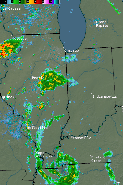 24-hour Radar Loop on Wednesday, May 30 |
Rainfall
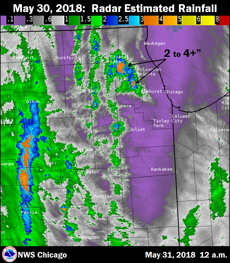 |
| Doppler Radar estimated rainfall. |
 |
| Doppler Radar estimated rainfall. |
Volunteer Observer Rainfall Reports
Public Information Statement
National Weather Service Chicago IL
0927 AM CDT Thu May 31 2018
...Morning Rainfall Roundup...
The following are rain amounts for the previous 24-hours
as measured in the morning by NWS Cooperative Observers
and CoCoRaHS observers.
Observations are usually taken between 6 AND 8 AM.
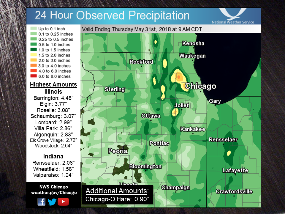
24-hour rainfall amounts
for Thursday(05/31/18)...
Illinois Rain
Location (County): fall (inches)
Barrington (Lake)............................4.48
Elgin 2WNW (Kane)............................3.77
Roselle 1ESE (Du Page).......................3.08
Schaumburg 2E (Cook).........................3.07
Elgin 2W (Kane)..............................3.06
Lombard 1NNW (Du Page).......................2.99
Villa Park 1NW (Du Page).....................2.86
Algonquin 1N (McHenry).......................2.83
Elk Grove Village 2WSW (Cook)................2.72
Elgin (Kane).................................2.70
Woodstock 4SW (McHenry)......................2.64
Hoffman Estates 5W (Cook)....................2.61
Montgomery 1SSE (Kendall)....................2.28
Cary (McHenry)...............................2.25
Woodstock 5nw (McHenry)......................2.16
Cary (McHenry)...............................2.13
Carol Stream (Du Page).......................2.00
Morris (Grundy)..............................1.93
Coal City 4NNW (Grundy)......................1.92
Carbon Hill 3.1N (Grundy)....................1.92
Capron (Boone)...............................1.90
Elburn (Kane)................................1.89
Elk Grove Village 1ESE (Cook)................1.89
Plainfield 5SW (Kendall).....................1.89
Elburn (Kane)................................1.89
Lake In The Hills 1ESE (McHenry).............1.86
Morris 6ESE (Grundy).........................1.84
Sterling 4NE (Lee)...........................1.81
Glen Ellyn 1NNW (Du Page)....................1.77
Elburn (Kane)................................1.77
Aurora (Kane)................................1.75
Wheaton 2NNE (Du Page).......................1.70
Byron 3N (Ogle)..............................1.70
Arlington Heights 3SSW (Cook)................1.68
Elmhurst 1ESE (Du Page)......................1.64
Elmhurst 2SE (Du Page).......................1.64
St. Charles 6NW (Kane).......................1.56
Plainfield 2SSE (Will).......................1.53
Elmhurst (Du Page)...........................1.52
Genoa (De Kalb)..............................1.51
La Grange Park 1SSW (Cook)...................1.50
Arlington Heights 1SW (Cook).................1.49
Plainfield 3NNW (Will).......................1.45
Geneva 4WSW (Kane)...........................1.40
De Kalb 1SW (De Kalb)........................1.38
De Kalb (De Kalb)............................1.37
Aurora (Kane)................................1.35
Dixon (Lee)..................................1.29
Lake in the Hills 2.5W (McHenry).............1.29
Palatine 1NNE (Cook).........................1.28
Dekalb (De Kalb).............................1.27
Ottawa (La Salle)............................1.24
West Chicago (Du Page).......................1.22
Hebron (McHenry).............................1.21
Ashton (Lee).................................1.19
La Salle (La Salle)..........................1.17
Cortland (De Kalb)...........................1.15
Palatine 1E (Cook)...........................1.14
Joliet (Will)................................1.14
Kingston 2WNW (De Kalb)......................1.13
Aurora 4SE (Du Page).........................1.12
Batavia 1WSW (Kane)..........................1.12
Naperville 4SSW (Will).......................1.11
Batavia (Kane)...............................1.07
De Kalb (De Kalb)............................1.07
Coal City 3N (Grundy)........................1.07
Woodstock 1SSW (McHenry).....................1.05
Aurora 4SE (Du Page).........................1.04
Sugar Grove 1NE (Kane).......................1.02
Countryside 1ENE (Cook)......................1.00
Joliet 2n (Will).............................1.00
Huntley (McHenry)............................0.99
North Aurora 2NE (Kane)......................0.97
Wilmington 6NW (Will)........................0.97
Kankakee (Kankakee)..........................0.93
Ohare (Cook).................................0.90
Morris 2SSE (Grundy).........................0.89
Peru 1ENE (La Salle).........................0.89
Geneva 1SSW (Kane)...........................0.88
McHenry (McHenry)............................0.88
Batavia 1WNW (Kane)..........................0.86
Lake Zurich 1N (Lake)........................0.85
Plainfield (Will)............................0.85
Crystal Lake (McHenry).......................0.84
Chatsworth (Livingston)......................0.80
Bridgeview 1NNW (Cook).......................0.80
Mazon 0.5ENE (Grundy)........................0.80
Chatsworth (Livingston)......................0.80
St Anne (Kankakee)...........................0.79
Gibson 2SW (Ford)............................0.78
Rockford 1NW (Winnebago).....................0.77
Steward (Lee)................................0.77
Lakemoor 2SE (Lake)..........................0.76
Joliet Lock/dam (Will).......................0.75
Morris 5NNW (Grundy).........................0.73
Crystal Lake 1WSW (McHenry)..................0.72
Momence 6SSW (Kankakee)......................0.71
Batavia 2WNW (Kane)..........................0.69
Lakemoor 2NW (McHenry).......................0.69
Lake Zurich (Lake)...........................0.69
Plano (Kendall)..............................0.67
Downers Grove 0.4NNE (Du Page)...............0.65
Midway Coop (Cook)...........................0.65
Lisle Morton Arb (Du Page)...................0.65
Ottawa 1NW (La Salle)........................0.63
Mendota (La Salle)...........................0.62
Streator (Livingston)........................0.60
Park Ridge 1WNW (Cook).......................0.58
Rochelle (Ogle)..............................0.58
Herscher 3E (Kankakee).......................0.57
Lake Villa 2WSW (Lake).......................0.56
Wonder Lake 1WNW (McHenry)...................0.56
Somonauk (De Kalb)...........................0.55
Seneca 2SSW (La Salle).......................0.53
Ottawa 2N (La Salle).........................0.53
Bannockburn (Lake)...........................0.51
Fox Lake 2SE (Lake)..........................0.50
Plainfield 3ESE (Will).......................0.50
Mundelein (Lake).............................0.50
Lake Villa 1SSW (Lake).......................0.49
Peru (La Salle)..............................0.49
Paxton (Ford)................................0.48
Chebanse (Kankakee)..........................0.46
Morris (Grundy)..............................0.44
Oak Lawn 2NW (Cook)..........................0.44
Rockford 3NE (Winnebago).....................0.44
Streator 4ENE (La Salle).....................0.42
Channahon 2SSE (Will)........................0.42
Lisle 1SW (Du Page)..........................0.41
Elgin 8WSW (Kane)............................0.40
Mundelein 2WNW (Lake)........................0.39
Westmont 1SSW (Du Page)......................0.38
Seneca 1NNE (La Salle).......................0.38
Chicago Ridge (Cook).........................0.36
Westmont (Du Page)...........................0.36
Park Ridge (Cook)............................0.32
Manteno 2NW (Kankakee).......................0.32
Paw Paw (Lee)................................0.32
Oak Lawn 2SE (Cook)..........................0.30
Naperville 2SE (Du Page).....................0.30
Waukegan (Lake)..............................0.30
Bourbonnais (Kankakee).......................0.28
Riverwoods (Lake)............................0.28
Romeoville (Will)............................0.28
Burr Ridge 2SW (Du Page).....................0.27
Gurnee 2W (Lake).............................0.27
Mundelein (Lake).............................0.27
Mendota (La Salle)...........................0.27
Waukegan 2N (Lake)...........................0.26
Zion (Lake)..................................0.26
Oak Lawn 2WNW (Cook).........................0.25
South Beloit 2SE (Winnebago).................0.25
Dwight (Livingston)..........................0.24
Buffalo Grove 2N (Lake)......................0.24
Elwood 5NE (Will)............................0.24
Lockport 1SE (Will)..........................0.24
Earlville 3S (La Salle)......................0.23
Oak Park 1NNE (Cook).........................0.23
Lake Bluff 1W (Lake).........................0.22
Beecher 3SSE (Will)..........................0.22
Midway (Cook)................................0.22
Glencoe (Cook)...............................0.21
Wilmington 3SE (Will)........................0.21
Wheeling (Cook)..............................0.21
Botanic Gardens (Cook).......................0.20
Oak Lawn (Cook)..............................0.20
Winthrop Harbor 1SSW (Lake)..................0.20
North Utica 6N (La Salle)....................0.20
Gibson 6NE (Ford)............................0.19
Cropsey 1NE (Livingston).....................0.19
Cicero 2SSW (Cook)...........................0.18
Harwood Heights (Cook).......................0.18
Lincolnwood 2E (Cook)........................0.18
Cissna Park 1S (Iroquois)....................0.18
Homer Glen 1ENE (Will).......................0.18
New Lenox 2SE (Will).........................0.18
Rockford (Winnebago).........................0.18
Watseka (Iroquois)...........................0.18
Oak Park 2S (Cook)...........................0.17
Winnetka 1ESE (Cook).........................0.17
Oak Park 1SW (Cook)..........................0.17
Manhattan 2SE (Will).........................0.17
Romeoville (Will)............................0.17
Worth (Cook).................................0.16
Flossmoor (Cook).............................0.16
New Lenox 4SE (Will).........................0.16
New Lenox 3E (Will)..........................0.15
Roscoe 2ESE (Winnebago)......................0.15
Roscoe 2se (Winnebago).......................0.15
Palos Park 1SW (Cook)........................0.14
Lansing (Cook)...............................0.14
Alsip (Cook).................................0.13
Park Forest (Cook)...........................0.13
Midlothian (Cook)............................0.12
Ravenswood Manor (Cook)......................0.11
Park Forest 1NNE (Cook)......................0.11
Gibson 3WNW (Ford)...........................0.11
Manhattan (Will).............................0.11
Homewood (Cook)..............................0.10
Watseka 6.9WNW (Iroquois)....................0.10
Chicago 6ESE (Cook)..........................0.09
Ashkum 5.6E (Iroquois).......................0.09
Chicago 6NNE (Cook)..........................0.08
Pontiac 1SE (Livingston).....................0.06
Belvidere (Boone)............................0.05
Fairbury (Livingston)........................0.04
Lansing (Cook)...............................0.03
Earlville 5NNE (De Kalb).....................0.03
Buckley (Iroquois)...........................0.02
Peotone (Will)...............................0.02
Pontiac (Livingston).........................0.02
Marseilles (La Salle)........................0.01
Indiana Rain
Location (County): fall (inches)
Rensselaer 8ENE (Jasper).....................2.06
Wheatfield 3S (Jasper).......................1.56
Rensselaer 10NNE (Jasper)....................1.50
(w9opr)Wheatfield 1ENE (Jasper)..............1.25
Valparaiso 4SW (Porter)......................1.24
Valparaiso 6WSW (Porter).....................1.20
Rensselaer 2N (Jasper).......................1.18
Valparaiso 6SSW (Porter).....................1.09
Valparaiso 1SE (Porter)......................1.08
Rensselaer 2SSW (Jasper).....................1.07
Remington (Jasper)...........................1.06
Valparaiso 2WSW (Porter).....................1.03
Valparaiso (Porter)..........................0.99
De Motte 6S (Jasper).........................0.98
Rensselaer 4N (Jasper).......................0.93
Valparaiso 5WSW (Porter).....................0.91
Rensselaer (Jasper)..........................0.91
Kentland 2SSE (Newton).......................0.88
Valparaiso 2N (Porter).......................0.87
Lakes Of The Four Seasons 2NNE (Porter)......0.87
Valparaiso 2NW (Porter)......................0.87
Gary 5ENE (Lake).............................0.86
Rensselaer 5NW (Jasper)......................0.85
De Motte 4SW (Jasper)........................0.82
Lake Village (Newton)........................0.79
Wheatfield 4WSW (Jasper).....................0.78
Kentland (Newton)............................0.78
Portage 3E (Porter)..........................0.76
Valparaiso 6NW (Porter)......................0.76
Hebron 4NE (Porter)..........................0.74
De Motte 1SSW (Jasper).......................0.73
De Motte 1NNW (Jasper).......................0.68
Mount Ayr 2NNE (Newton)......................0.67
Chesterton 4E (Porter).......................0.62
Morocco (Newton).............................0.60
Lowell (Lake)................................0.48
Porter 1S (Porter)...........................0.45
Crown Point 2WSW (Lake)......................0.43
Winfield 1NE (Lake)..........................0.43
Crown Point (Lake)...........................0.35
Crown Point 1N (Lake)........................0.35
(w9mal)Merrillville 2NNW (Lake)..............0.35
Schererville 1E (Lake).......................0.30
Griffith 1N (Lake)...........................0.30
St. John (Lake)..............................0.26
$$
Automated Gauge Rainfall Reports
Public Information Statement
National Weather Service Chicago IL
200 AM CDT Thu May 31 2018 /300 AM EDT Thu May 31 2018/

...RAINFALL REPORTS FROM WEDNESDAY MAY 30...

Observations are collected from a variety of sources with varying
equipment and exposures. We thank all volunteer weather observers
for their dedication. Not all data listed are considered official.

Location                     Amount    Time/Date       Provider
-----------------------------------------------------------------

...Illinois...

...Cook County...
1 SE Hoffman Estates         2.95 in   0530 PM 05/30   COCORAHS
Chicago O`Hare               0.90 in   0100 AM 05/31   ASOS
1 ENE Logan Square           0.76 in   0124 AM 05/31   URBANET
Riverside                    0.52 in   1245 AM 05/31   USARMY-COE
Chicago Midway               0.22 in   0100 AM 05/31   ASOS
Wheeling - Chi Exec Airport  0.21 in   0100 AM 05/31   ASOS
1 WNW Burnham                0.20 in   0100 AM 05/31   USARMY-COE

...De Kalb County...
DeKalb - Taylor Aiport       1.27 in   0100 AM 05/31   AWOS
Il Shabbona 5 NNE            1.08 in   0100 AM 05/31   GOES
5 NNE Shabbona               0.69 in   0100 AM 05/31   GOES

...DuPage County...
Villa Park                   2.55 in   0120 AM 05/31   HADS
Oakbrook Terrace             2.16 in   0115 AM 05/31   HADS
1 NE Oak Brook               1.71 in   0130 AM 05/31   HADS
2 SSE West Chicago           1.47 in   0120 AM 05/31   HADS
1 SW Hanover Park            1.42 in   0115 AM 05/31   HADS
West Chicago - DuPage Airpor 1.22 in   0100 AM 05/31   ASOS

...Grundy County...
3 SSW Minooka                1.37 in   0100 AM 05/31   HADS
1 SSE Morris                 0.74 in   1245 AM 05/31   HADS

...Kane County...
Sugar Grove - Aurora Airport 1.76 in   0100 AM 05/31   ASOS
2 WNW Saint Charles          1.67 in   0115 AM 05/31   COOP
2 WNW Montgomery             1.36 in   1230 AM 05/31   HADS
2 W Batavia                  0.94 in   0100 AM 05/31   HADS

...Kankakee County...
4 E Chebanse                 0.96 in   1245 AM 05/31   USGS

...Kendall County...
Oswego                       2.06 in   0115 AM 05/31   HADS

...La Salle County...
1 W Naplate                  1.83 in   1245 AM 05/31   HADS
2 ENE Leonore                1.65 in   1245 AM 05/31   HADS
Peru - Duncan Field Airport  1.41 in   0100 AM 05/31   AWOS
Ottawa                       0.87 in   1230 AM 05/31   HADS

...Lake County...
2 E Gages Lake               0.72 in   0130 AM 05/31   HADS
3 N Wadsworth                0.36 in   1230 AM 05/31   HADS
Waukegan Airport             0.30 in   0100 AM 05/31   ASOS

...Lee County...
Dixon                        1.39 in   0115 AM 05/31   HADS

...Livingston County...
Pontiac                      0.68 in   1245 AM 05/31   USARMY-COE
Pontiac Airport              0.59 in   0655 PM 05/30   AWOS

...McHenry County...
Hebron                       0.67 in   1240 AM 05/31   HADS
Spring Grove                 0.40 in   0100 AM 05/31   USGS

...Will County...
Shorewood                    2.37 in   0645 PM 05/30   USARMY-COE
Joliet Airport               1.14 in   0100 AM 05/31   AWOS
4 W Bolingbrook              0.80 in   1245 AM 05/31   HADS
West Br Dupage River         0.79 in   0115 AM 05/31   ALERT
Rockdale                     0.58 in   0100 AM 05/31   HADS
1 WNW Fairmont               0.38 in   0100 AM 05/31   HADS
Romeoville - NWS Chicago     0.28 in   0100 AM 05/31   NWS
3 NNE Wilmington             0.26 in   0105 AM 05/31   RAWS

...Winnebago County...
Rockton                      1.18 in   1230 AM 05/31   HADS
Rockford Airport             0.26 in   0100 AM 05/31   ASOS
3 ENE New Millford           0.23 in   1230 AM 05/31   HADS

...Indiana...

...Benton County...
2 SSE Boswell                1.76 in   0100 AM 05/31   HADS

...Jasper County...
1 E Rensselaer               0.81 in   0130 AM 05/31   HADS

...Lake County...
Hobart                       0.48 in   0130 AM 05/31   HADS
5 E Schneider                0.39 in   1245 AM 05/31   HADS
2 NW Merrillville            0.29 in   0130 AM 05/31   HADS
2 NNE Griffith               0.22 in   0115 AM 05/31   HADS
Dyer                         0.17 in   0100 AM 05/31   HADS

...Porter County...
Valparaiso Airport           0.99 in   0100 AM 05/31   ASOS
Porter                       0.60 in   0117 AM 05/31   RAWS


$$

MTF
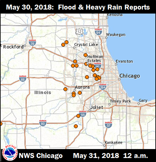
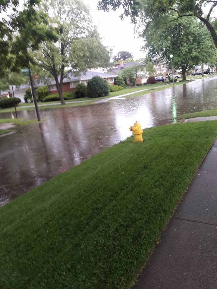
Storm & Flooding Reports
 |
 |
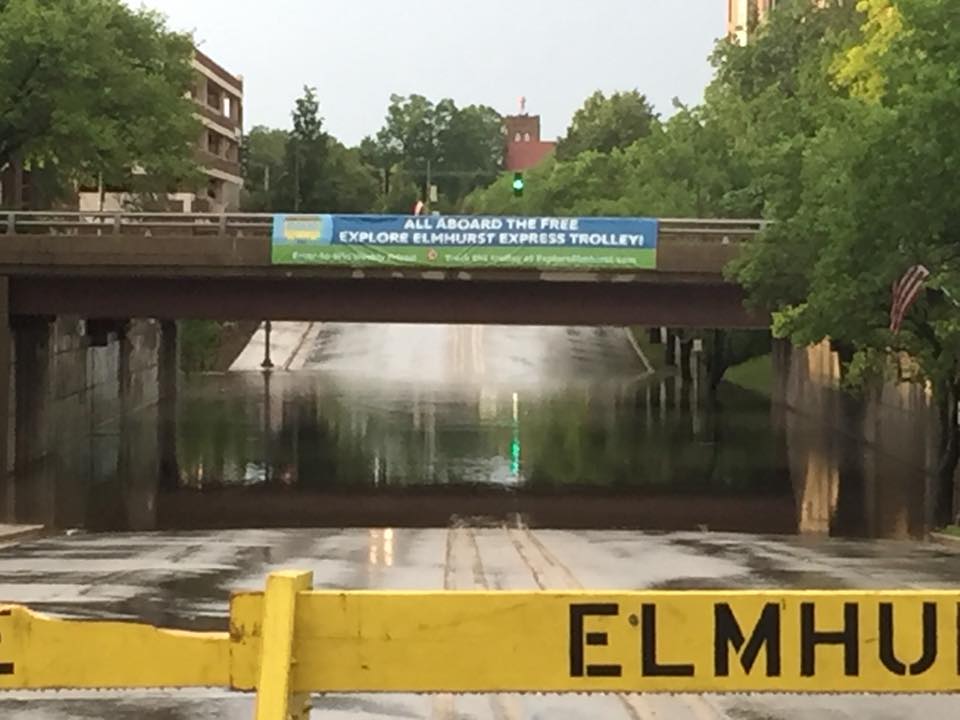 |
| Storm Reports | Elmhurst flooding, near the intersection of Mitchell and Adams Streets. Photo courtesy of John Szuberla via WGN Chicago. | Elmhurst flooding near downtown, courtesy of Pat Abinion via WGN Chicago. |
PRELIMINARY LOCAL STORM REPORT...SUMMARY
NATIONAL WEATHER SERVICE CHICAGO/ROMEOVILLE IL
1100 PM CDT WED MAY 30 2018

..TIME...   ...EVENT...      ...CITY LOCATION...     ...LAT.LON...
..DATE...   ....MAG....      ..COUNTY LOCATION..ST.. ...SOURCE....
            ..REMARKS..

0850 PM     HEAVY RAIN       WOODSTOCK               42.31N 88.44W
05/30/2018  M2.09 INCH       MCHENRY            IL   CO-OP OBSERVER

            DAILY RAINFALL TOTAL RECORDED BY SUPPLEMENTAL COOP
            OBSERVER.

0734 PM     FLOOD            ELMHURST                41.90N 87.94W
05/30/2018                   DUPAGE             IL   BROADCAST MEDIA

            RESIDENTIAL STREET FLOODING IN ELMHURST RELAYED VIA
            BROADCAST MEDIA ON TWITTER. ALSO...FLOOD PRONE UNDERPASS
            IN DOWNTOWN ELMHURST CLOSED DUE TO FLOODING.

0730 PM     FLOOD            ELMHURST                41.90N 87.94W
05/30/2018                   DUPAGE             IL   EMERGENCY MNGR

            RT 83 CLOSED BETWEEN ST CHARLES RD AND NORTH AVE. RELAYED
            BY DUPAGE OHSEM.

0700 PM     HEAVY RAIN       2 WSW ELK GROVE VILLAGE 41.99N 88.03W
05/30/2018  M2.72 INCH       COOK               IL   COCORAHS

            MOST OF THE RAINFALL OCCURRED IN PAST 3 HOURS UP TO
            REPORT TIME...ESPECIALLY BETWEEN 4PM AND 630PM. LOW AREA
            PONDING WITH RAPID RUNOFF.

0700 PM     HEAVY RAIN       SSE CAROL STREAM        41.91N 88.13W
05/30/2018  M2.00 INCH       DUPAGE             IL   COCORAHS

            RAINFALL IN PAST 3 HOURS. MINOR FLOODING REPORTED.

0646 PM     FLOOD            3 ESE HOFFMAN ESTATES   42.04N 88.08W
05/30/2018                   COOK               IL   PUBLIC

            ROSELLE ROAD AND HIGGINS ROAD INTERSECTION CLOSED DUE TO
            FLOODING.

0639 PM     FLASH FLOOD      VILLA PARK              41.89N 87.98W
05/30/2018                   DUPAGE             IL   EMERGENCY MNGR

            A SECTION OF SOUTHBOUND ARDMORE AT NORTH AVE AND ARDMORE
            CLOSED DUE TO FLOODING...AS REPORTED BY A TRAINED
            SPOTTER. ADDISON ROAD REMAINED CLOSED FROM NORTH AVE TO
            ARMITAGE AS OF 816 PM AND FIRE DEPARTMENT HAD TO PERFORM
            ONE WATER RESCUE...RELAYED VIA DUPAGE OHSEM.

0630 PM     FLASH FLOOD      W ADDISON               41.93N 88.01W
05/30/2018                   DUPAGE             IL   EMERGENCY MNGR

            WIDESPREAD FLOODING THROUGHOUT ADDISON...PARTICULARLY
            WEST SIDE...WITH MAJOR ROADS FLOODED. 12 TO 20 VEHICLES
            WILL NEED TO BE TOWED DUE TO WATER DAMAGE. APPROXIMATELY
            100 HOMES HAVE FLOOD DAMAGE. EMERGENCY OPERATIONS CENTER
            HAS BEEN ACTIVATED. RELAYED VIA DUPAGE OHSEM. TIME
            ESTIMATED BY RADAR.

0621 PM     FLOOD            1 NW ELMHURST           41.91N 87.96W
05/30/2018                   DUPAGE             IL   TRAINED SPOTTER

            WATER UP TO THE TOP OF THE CURBS...ABOUT 6 INCHES OF
            STANDING WATER...ACROSS ALL LANES OF TRAFFIC OF NORTH
            AVENUE...ROUTE 64.

0620 PM     FLOOD            1 NW BARRINGTON         42.16N 88.15W
05/30/2018                   LAKE               IL   BROADCAST MEDIA

            US ROUTE 14 CLOSED DUE TO FLOODING BETWEEN HART ROAD AND
            IL ROUTE 59. VIA BROADCAST MEDIA ON TWITTER.

0610 PM     HEAVY RAIN       1 ESE ELK GROVE VILLAGE 42.00N 87.97W
05/30/2018  M1.62 INCH       COOK               IL   COCORAHS

            RAINFALL IN PAST 75 MINUTES UP TO REPORT TIME. MINOR
            FLOODING REPORTED.

0535 PM     HEAVY RAIN       2 E SCHAUMBURG          42.03N 88.04W
05/30/2018  M2.90 INCH       COOK               IL   COCORAHS

            IN LESS THAN 1 HOUR.

0526 PM     FLOOD            HOFFMAN ESTATES         42.06N 88.14W
05/30/2018                   COOK               IL   TRAINED SPOTTER

            APPROXIMATELY 5 INCHES FLOWING WATER ON SHOE FACTORY
            ROAD, EAST OF BARTLETT ROAD.

0517 PM     FLOOD            MINOOKA                 41.46N 88.26W
05/30/2018                   GRUNDY             IL   LAW ENFORCEMENT

            FLOODING AT INTERSECTION OF MCCLENDON AND MINOOKA ROAD.

0450 PM     HEAVY RAIN       W SLEEPY HOLLOW         42.09N 88.31W
05/30/2018  M3.67 INCH       KANE               IL   COCORAHS

            MEASURED IN PAST 90 MINUTES UP TO REPORT TIME. MINOR
            FLOODING REPORTED.

0445 PM     HEAVY RAIN       3 N CARBON HILL         41.34N 88.30W
05/30/2018  M1.29 INCH       GRUNDY             IL   COCORAHS

            IN 45 MINUTE PERIOD UP TO REPORT TIME. MINOR FLOODING
            REPORTED. RETIRED NWS EMPLOYEE.

0445 PM     HEAVY RAIN       4 SE AURORA             41.73N 88.24W
05/30/2018  M0.94 INCH       DUPAGE             IL   COCORAHS

            RAINFALL IN 30 MINUTES. MINOR FLOODING REPORTED.

0420 PM     HEAVY RAIN       4 SSW AURORA            41.72N 88.33W
05/30/2018  M1.86 INCH       KENDALL            IL   COCORAHS

            RAINFALL LAST 45 MINUTES

0415 PM     FLOOD            ELGIN                   42.04N 88.29W
05/30/2018                   KANE               IL   TRAINED SPOTTER

            FIVE TO SIX INCHES OF STANDING WATER ON LIBERTY BETWEEN
            COLUMBIA AND LINCOLN.

0410 PM     FLOOD            OSWEGO                  41.70N 88.33W
05/30/2018                   KENDALL            IL   AMATEUR RADIO

            RESIDENTIAL FLOODING IN SOUTHBURY SUBDIVISION. SOUTHBURY
            BLVD AND COLCHESTER DRIVE IS FLOODED AND WATER IS RISING
            QUICKLY IN THE INTERSECTION. WATER IS OVER THE CURB UP TO
            THE SIDEWALK.

0355 PM     FLOOD            SUGAR GROVE             41.77N 88.46W
05/30/2018                   KANE               IL   TRAINED SPOTTER

            WATER FLOWING ON THE ROADS AT JERICHO AND GRANARD ROADS
            IN SUGAR GROVE. RAPID RISING WATER AND WATER FILLING IN
            DITCHES, AND FIELDS QUICKLY FILLING WITH WATER.

0330 PM     FUNNEL CLOUD     GIBSON CITY             40.47N 88.38W
05/30/2018                   FORD               IL   TRAINED SPOTTER

            SEPARATE REPORTS OF FUNNEL CLOUDS NEAR GIBSON
            CITY...FIRST WAS ABOUT 5 MILES NORTH OF GIBSON CITY AT
            AROUND 320PM RELAYED VIA TWITTER AND SECOND WAS ABOUT 1
            MILE EAST OF GIBSON CITY AT AROUND 335PM RELAYED BY NWS
            LINCOLN OFFICE.

0310 PM     HEAVY RAIN       6 SW EAST DUNDEE        42.04N 88.34W
05/30/2018  M2.87 INCH       KANE               IL   COCORAHS

            RAINFALL PAST 70 MINUTES

0300 PM     HEAVY RAIN       6 ENE MARENGO           42.28N 88.49W
05/30/2018  M1.49 INCH       MCHENRY            IL   COCORAHS

            RAIN FELL IN 1 HOUR.

0144 PM     FUNNEL CLOUD     1 W FLANAGAN            40.88N 88.88W
05/30/2018                   LIVINGSTON         IL   LAW ENFORCEMENT

            NEAR WOODFORD AND LIVINGSTON COUNTY LINE.


&&

$$

RC
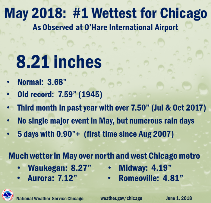
Wettest May in Chicago
 |
Tropical Remnants Climatology
 |
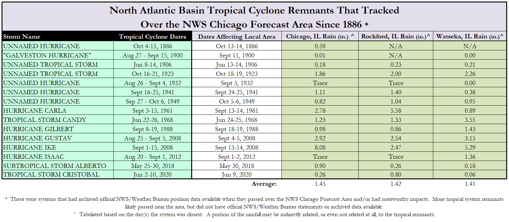 |
| Tropical cyclone remnant tracks that have impacted the NWS Chicago CWA. | Rainfall impacts from tropical cyclone remnants. |
For more, visit our tropical remnants climatology page.
Service
 |
 |
 |
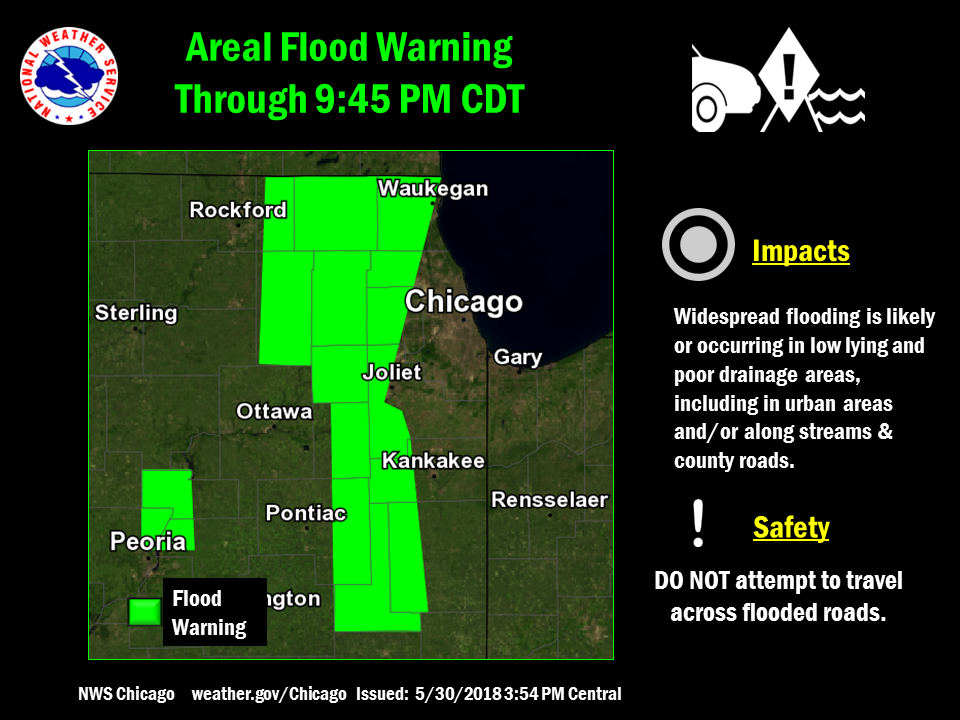 |
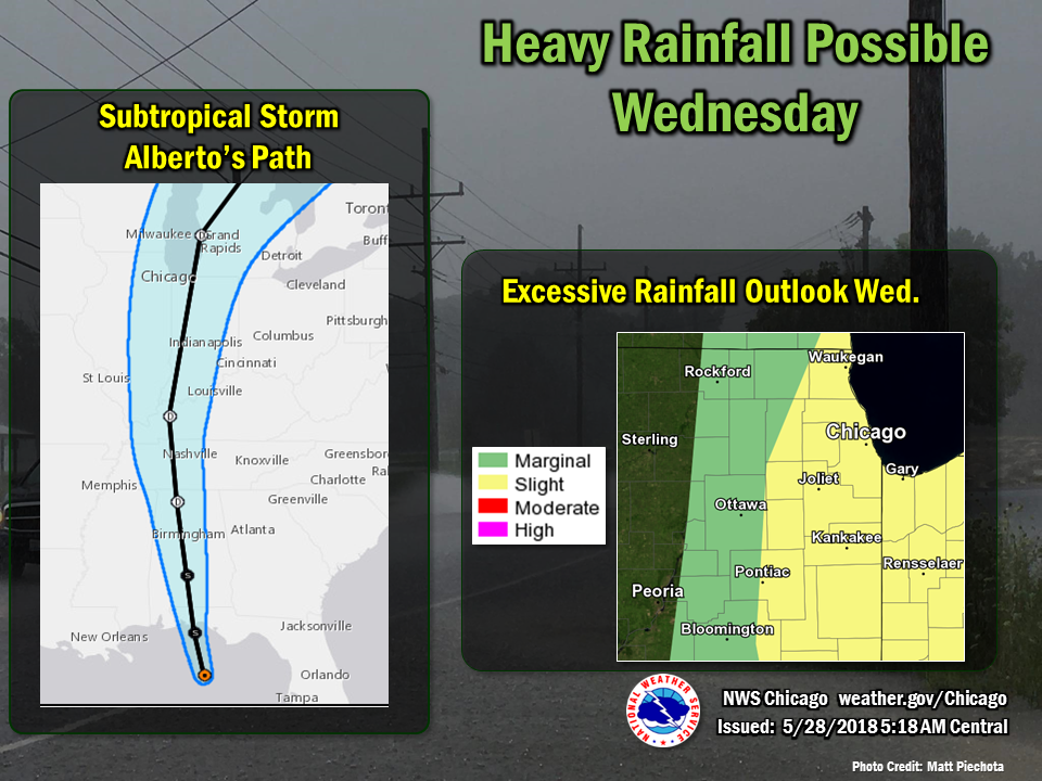
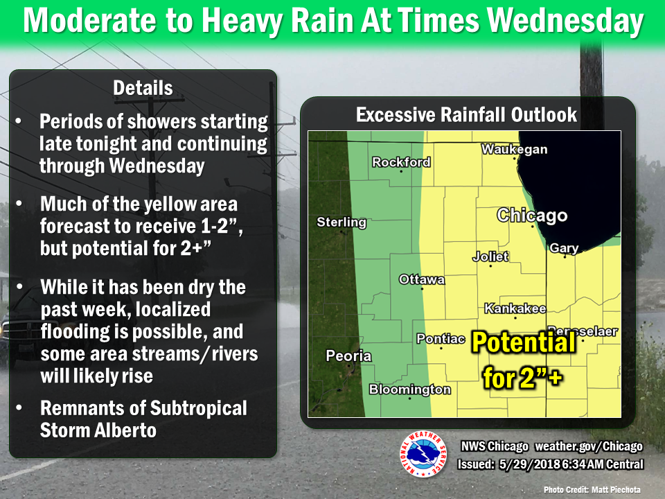
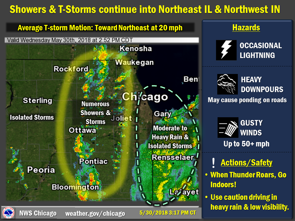
| Issued May 28 a.m. | Issued May 29 a.m. | Issued May 30 3:17 pm | Flood Warning Issued May 30 3:54 pm |
Meteorology
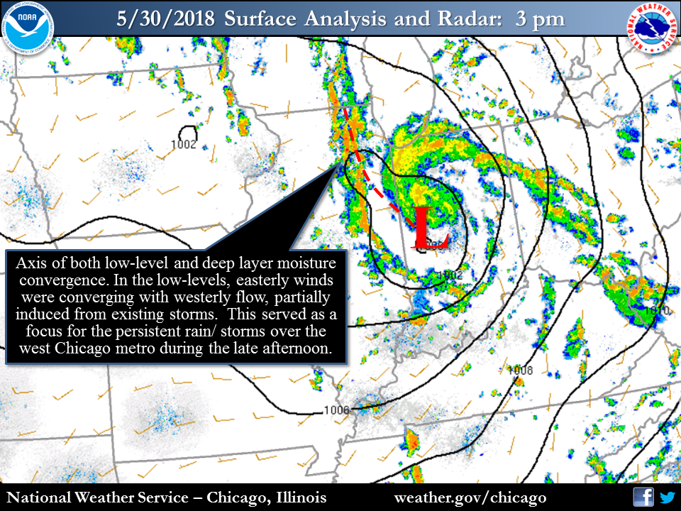 |
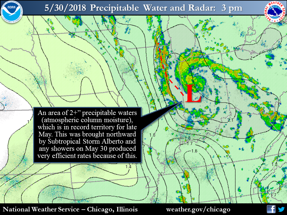 |
| Surface Weather Map at 3 pm on May 30 | Precipitable Water at 3 pm on May 30 |
Additional Info
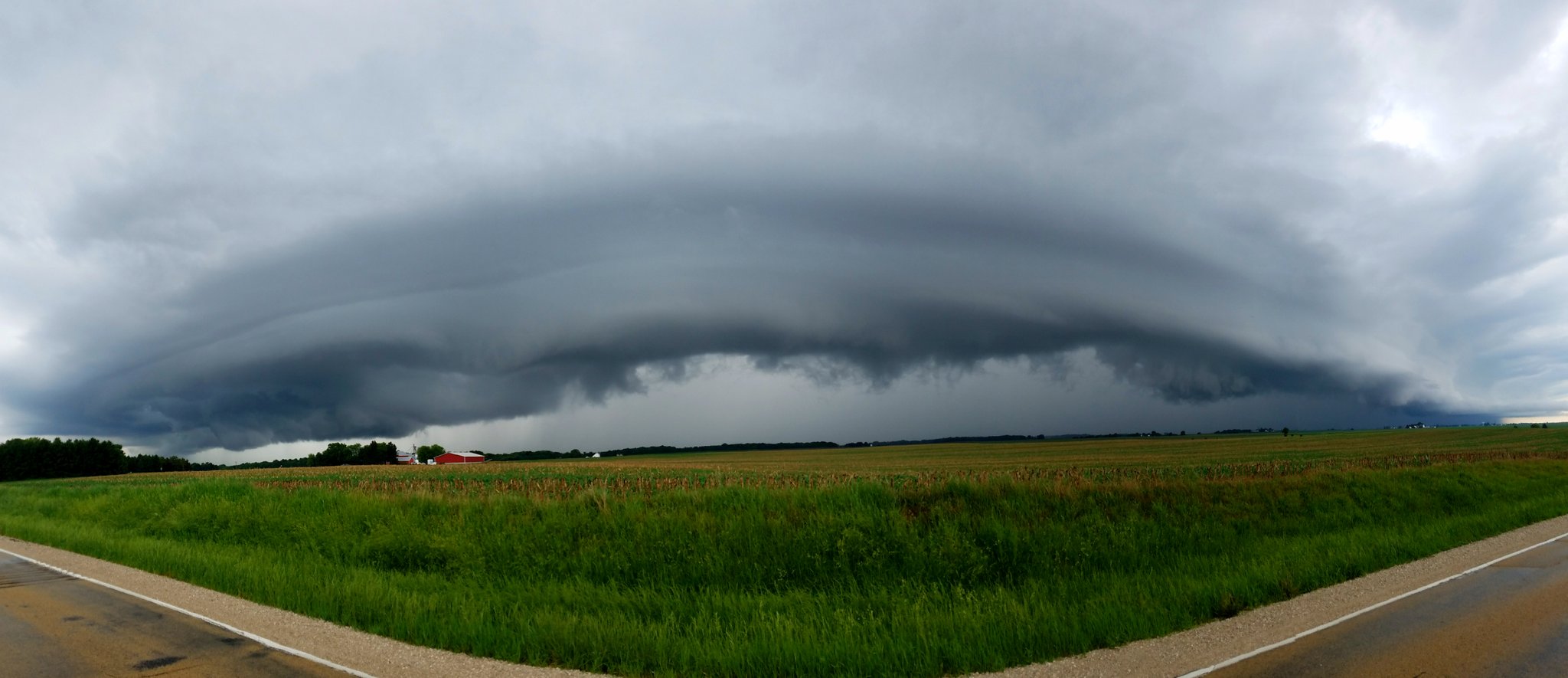 |
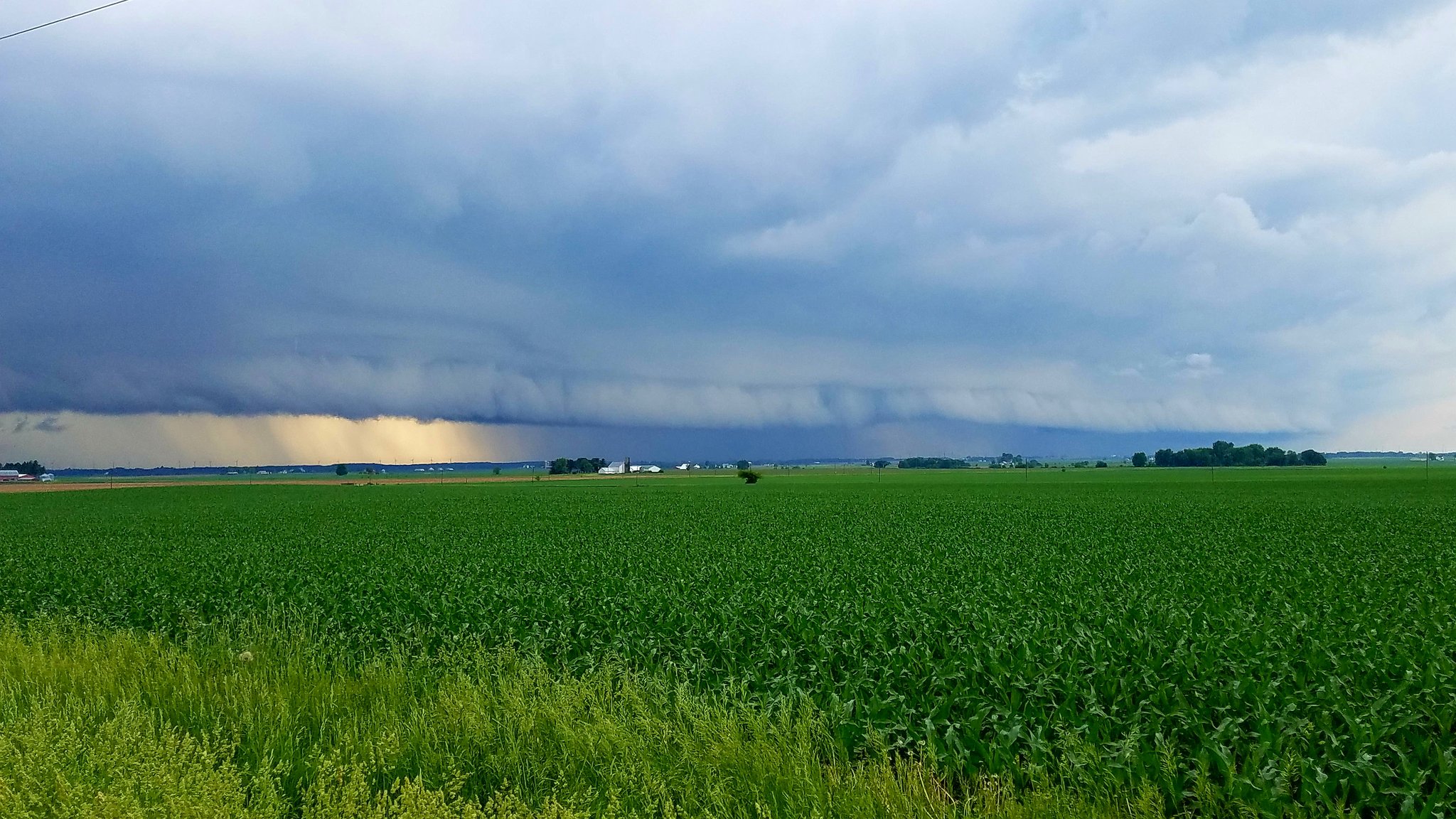 |
| Shelf cloud near Hinckley, IL, courtesy of Bob Waszak | Shelf cloud over Southern DeKalb County, courtesy of Bob Waszak |
 |
Media use of NWS Web News Stories is encouraged! Please acknowledge the NWS as the source of any news information accessed from this site. Additional recaps can be found on the NWS Chicago Past Events Page |
|

