|
Easter Sunday thunderstorms bring swaths of accumulating hail |
|
 |
|
| Thunderstorm approaching New Home Sunday evening (9 April 2023). The picture is courtesy of Annjulie Johnson. | |
|
Easter 2023 started on the quiet side, with mild temperatures, considerable cloudiness and a few sprinkles and light showers speckled across the region. The increased cloud cover was a sign of things to come and as temperatures warmed into the upper 70s and lower 80s scattered thunderstorms quickly developed during the mid-late afternoon. |
|
 |
|
| "RGB-True Color" satellite animation valid from 11:56 am to 1:26 pm on Sunday (9 April 2023). | |
| The initial thunderstorm development was concentrated along several low-level boundaries stretching across the southern Texas Panhandle and northern South and Rolling Plains. The storms were fueled by just enough moisture and instability, that when coupled with cold air and a weak disturbance aloft, several of the storms became strong to severe. | |
 |
|
| Drone footage of storm moving over Lubbock Sunday evening (9 April 2023). Image is courtesy of Joe Jurecka. | |
| Given the relatively dry, warm and deeply mixed lower levels of the atmosphere, favorable for significant sub-cloud evaporation, it was not surprising that the activity generated plenty of strong wind gusts, with a few exceeding severe thresholds (58 mph or greater). Specifically, both the Olton and White River Lake West Texas Mesonet sites measured peak wind gusts of 62 mph. | |
 |
|
| Lubbock WSR-88D radar animation valid from 7:13 am to 10:13 pm on Sunday (9 April). | |
|
Even more impressive than the wind was the copious amount of hail that several of the thunderstorms dropped. Although the hail was generally on the smaller side (pea to dime size hail, with the occasional quarter size stone), a few of the storms produced LOTS of hail, covering the ground several inches deep or more. |
|
 |
|
| LOTS of small hail falling in Lubbock Easter evening (9 April). The image is courtesy of Alex Root. | |
| The hail was generally small enough that it didn't cause major property damage. However, the large quantities of hail did shred any and all plants that were exposed to it, including trees and flowers too, causing much distress to those who have recently ventured out and started planting their gardens. | |
 |
|
| Accumulating hail in Shallowater (left) and Lubbock (right) on Easter Sunday (9 April 2023). The pictures are courtesy of Bruce Haynie and Heath Brown, respectively. | |
| The ice covered roads affected Shallowater and parts of Lubbock, among other locations, and made it look like winter. The ice-covered roads did make it slick for a bit, and in some spots the hail didn't completely melt off until the next morning. | |
 |
|
| Wolfforth storm, as viewed from near Ropesville, Easter evening (9 April 2023). This image is courtesy of Wes Burgett. | |
|
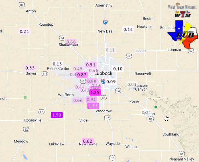
The thunderstorms did make for picturesque skies, while also bringing much-needed moisture, albeit often with hail, to a number of locales. The below graphic illustrates where the heaviest swaths of rain fell, with most of the rain falling in a short amount of time. Where the heaviest rain fell, minor flooding did occur, including parts of southwest Lubbock and as well as around Tahoka. |
|
 |
|
| 24-hour radar-estimated and bias-corrected rainfall ending at 7 am on Monday (10 April). The rainfall measured by the West Texas Mesonet (WTM) over this period can be VIEWED HERE. The WTM rainfall, along with supplemental observations, recorded around Lubbock can be FOUND HERE. | |
|
Officially, the Lubbock Airport only recorded 0.08 inches of rain, missing out on a bulk of activity which largely targeted the western and southwestern side of the city where totals near and above an inch were common. The rain was a little more generous at the Childress Airport where 0.49 inches was measured on Easter. |
|
|
Preliminary storm reports for this active Easter afternoon and evening can be found below: |
|
PRELIMINARY LOCAL STORM REPORT...SUMMARY
NATIONAL WEATHER SERVICE LUBBOCK TX
1015 PM CDT SUN APR 9 2023

..TIME...   ...EVENT...      ...CITY LOCATION...     ...LAT.LON...
..DATE...   ....MAG....      ..COUNTY LOCATION..ST.. ...SOURCE....
            ..REMARKS..

0318 PM     HAIL             3 E CHILDRESS           34.43N 100.20W
04/09/2023  U0.75 INCH       CHILDRESS          TX   PUBLIC

            REPORT FROM MPING: DIME (0.75 IN.).

0610 PM     TSTM WND GST     6 S OLTON               34.09N 102.12W
04/09/2023  M62 MPH          LAMB               TX   MESONET

            WEST TEXAS MESONET.

0615 PM     HAIL             3 NW SHALLOWATER        33.72N 102.03W
04/09/2023  M1.00 INCH       LUBBOCK            TX   PUBLIC

            COPIOUS ACCUMULATIONS OF HAIL.

0645 PM     HAIL             1 E SHALLOWATER         33.69N 101.98W
04/09/2023  E1.00 INCH       LUBBOCK            TX   PUBLIC


0700 PM     HAIL             LOCKNEY                 34.12N 101.44W
04/09/2023  E1.00 INCH       FLOYD              TX   PUBLIC

            A FEW TO QUARTER SIZE.

0707 PM     HAIL             3 W LUBBOCK             33.59N 101.90W
04/09/2023  E1.00 INCH       LUBBOCK            TX   PUBLIC

            SEVERAL REPORTS OF HAIL IN WEST LUBBOCK
            RANGING IN SIZE FROM NICKEL TO QUARTER SIZE.

0715 PM     HAIL             4 SSW LUBBOCK           33.52N 101.90W
04/09/2023  E1.00 INCH       LUBBOCK            TX   NWS EMPLOYEE

            56TH STREET AND MEMPHIS AVE.

0715 PM     HAIL             5 SW LUBBOCK            33.54N 101.91W
04/09/2023  E1.25 INCH       LUBBOCK            TX   PUBLIC

            56TH ST AND UTICA AVE.

0718 PM     HAIL             1 S FLOYDADA            33.97N 101.34W
04/09/2023  U0.75 INCH       FLOYD              TX   PUBLIC

            REPORT FROM MPING: DIME (0.75 IN.).

0719 PM     HAIL             4 SSW LUBBOCK           33.53N 101.88W
04/09/2023  M1.00 INCH       LUBBOCK            TX   OFFICIAL NWS OBS

            NWS OFFICE MEASURED MOSTLY DIME TO NICKEL
            SIZE. HAIL BEGAN AT 709 PM AND ENDED AT 718
            PM.

0729 PM     HAIL             5 SW LUBBOCK            33.54N 101.90W
04/09/2023  U0.75 INCH       LUBBOCK            TX   PUBLIC

            REPORT FROM MPING: DIME (0.75 IN.).

0753 PM     TSTM WND GST     1 SE RALLS              33.67N 101.38W
04/09/2023  M59 MPH          CROSBY             TX   MESONET

            WEST TEXAS MESONET.

0824 PM     TSTM WND GST     6 NW WHITE RIVER LAKE   33.53N 101.17W
04/09/2023  M62 MPH          CROSBY             TX   MESONET

            WEST TEXAS MESONET. FIRST SEVERE GUST TO 58
            MPH AT 823 PM.

0845 PM     HAIL             TAHOKA                  33.17N 101.79W
04/09/2023  E1.00 INCH       LYNN               TX   CO-OP OBSERVER


0900 PM     FLASH FLOOD      TAHOKA                  33.17N 101.79W
04/09/2023                   LYNN               TX   LAW ENFORCEMENT

            SOME VEHICLES SUBMERGED BY FLOOD WATERS.
            WIDESPREAD ROAD AND STREET FLOODING. TIME
            ESTIMATED.

