
Tropical system in the Gulf expected to gradually strengthen the next couple of days off the Florida Panhandle and Alabama coasts. Instances of flash flooding will be possible through Thursday along the eastern and central Gulf Coast. Severe thunderstorms will develop and move along a cold front crossing the Upper Midwest, and through the Ohio Valley/Mid-Atlantic on Tuesday. Read More >
|
A record warm winter for West Texas |
|
 |
|
|
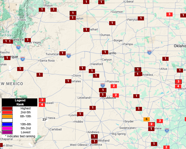
Map showing the 2025-2026 winter temperature rankings at observation sites across the region. |
|
|
If you thought this winter was warm, you were correct! Despite a bitterly cold shot of Arctic air in late January, overall the winter of 2025-2026 leaned heavily to the warm side. As illustrated in the above graphic, many locations across West Texas, eastern New Mexico and western Oklahoma recorded their warmest winter on record. |
|
 |
|
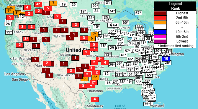
| Map showing the 2025-2026 winter temperature rankings at observation sites across the nation. | |
|
The extreme winter warmth wasn't confined to the region, but affected much of the western half of the United States, as the above map shows. The widespread warmth was largely a result of a semi-permanent ridge that encompassed much of the west through most of the winter, supplying warmer and generally drier conditions. On the other side of the country, a corresponding trough allowed for frequent intrusions of Canadian and Artic air that kept that side of the nation much cooler/colder. This western ridge and eastern trough pattern is favored during cool-season La Nina episodes (a weak La Nina was present throughout the winter), though the magnitude and duration of the ridge/trough pattern was exceptional. |
|
 |
|
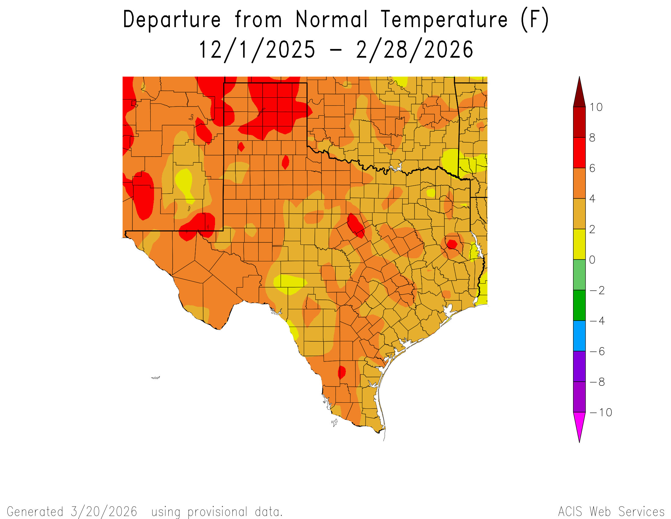
| 2025-2026 winter average temperature departure from normal for Texas. The average temperature for Texas over the entire winter can be FOUND HERE. | |
|
Looking into the details, much of the region experienced average winter temperatures 4 to 6+ degrees above the long term average. Officially, Lubbock's average temperature was 48.5˚F, and astounding 2.8˚F above the previous record of 45.7˚F, set in 2017. The warm winter was punctuated by an extraordinary warm period around Christmas where Lubbock exceeded the previous all-time December high temperature of 83 degrees on 4 out of 6 days, including a high of 86˚F on Christmas Day! The record warmth wasn't just at Lubbock, it included all four corners of our service area, including Friona, Denver City, Childress and Aspermont. |
|
 |
|
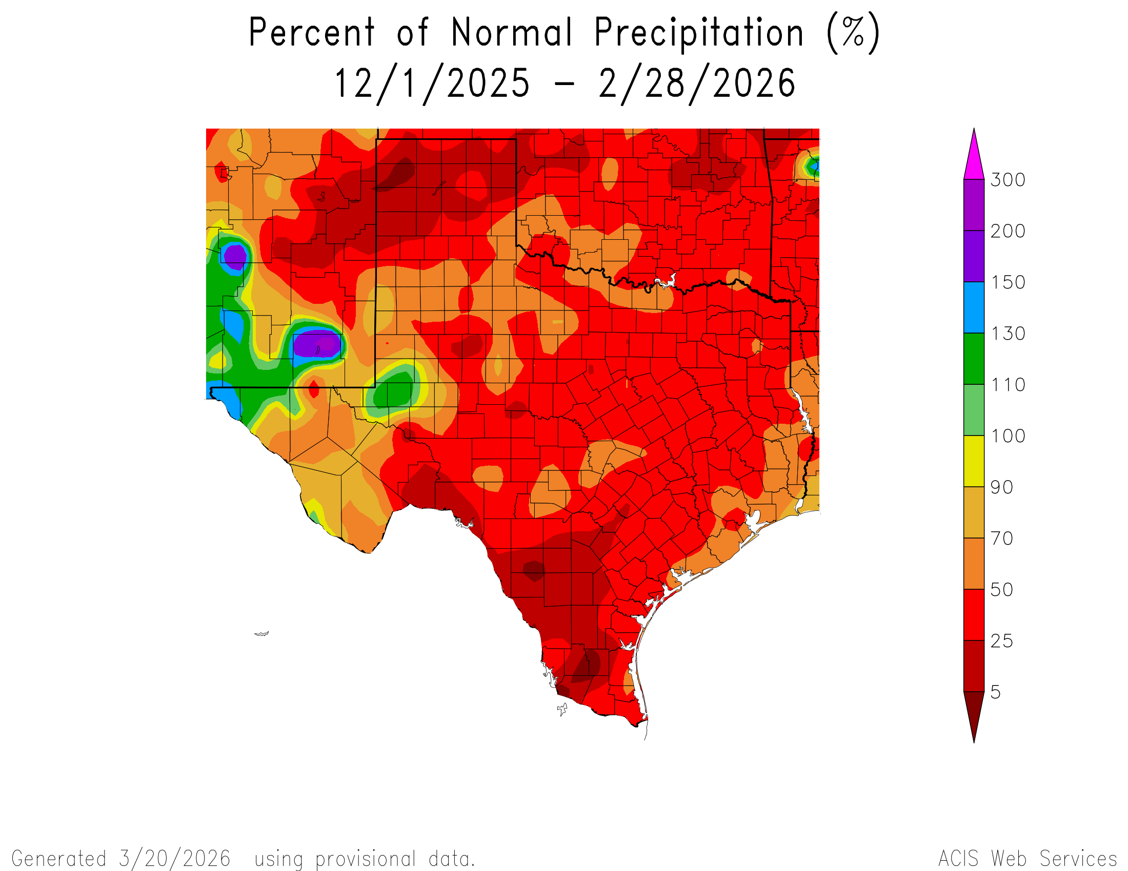
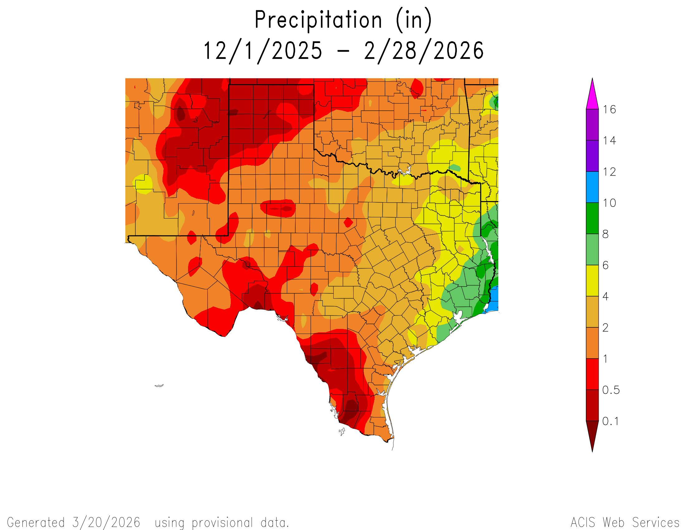
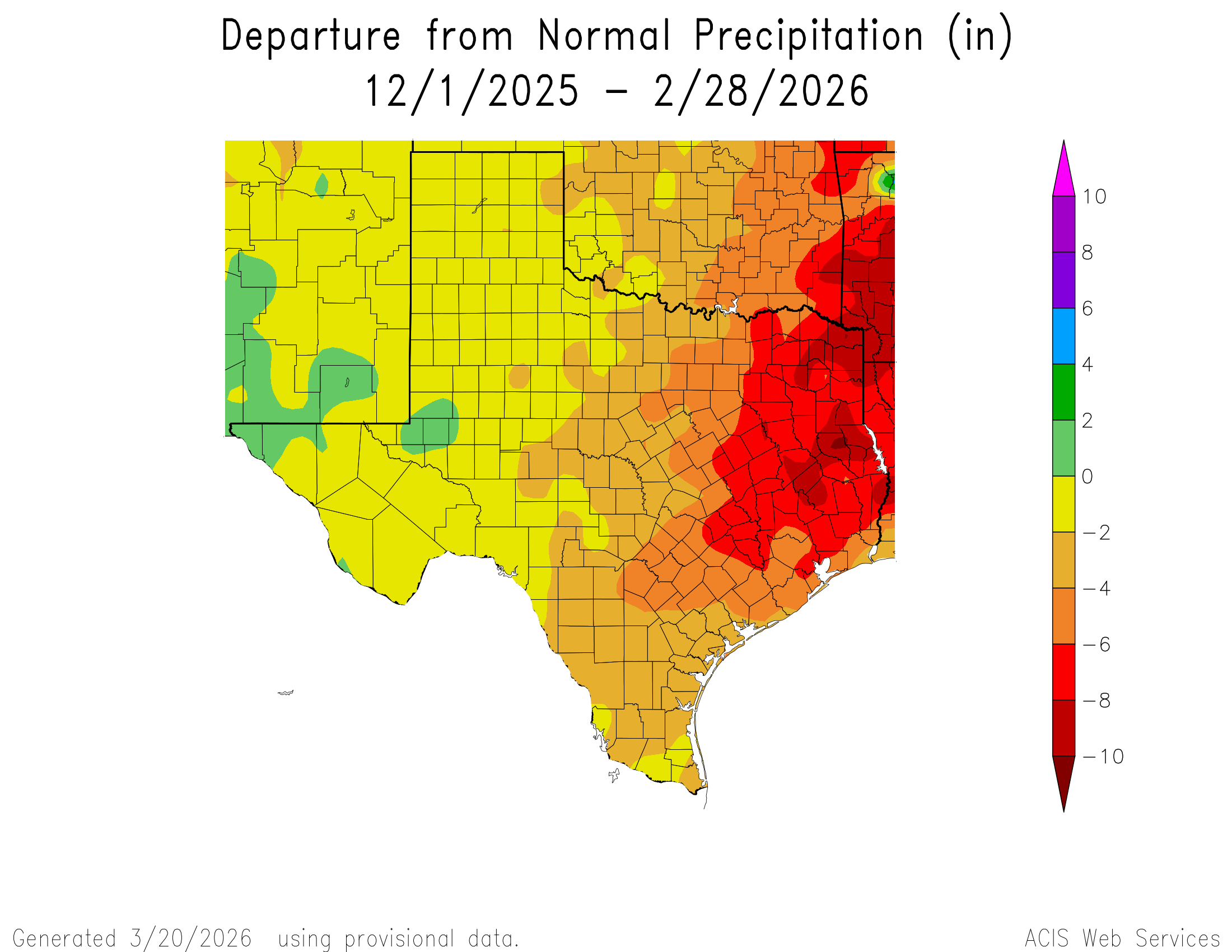
| 2025-2026 winter percent of normal precipitation for Texas. The winter precipitation totals for Texas can be VIEWED HERE and the departure from normal precipitation can be OBTAINED HERE. | |
|
As is often the case, the warmth was paired with relatively dry conditions. Aside from the wintry weather during the brief Arctic intrusion in late January, widespread rain on February 13th, and spotty severe thunderstorms on March 5th, dry conditions dominated the 2025-2026 winter. The entire South Plains, Rolling Plains and southern Texas Panhandle finished the winter with below average precipitation. The dry conditions were exacerbated by the record warmth and resulted in expanding and intensifying drought through the winter. |
|
 |
 |
 |
|
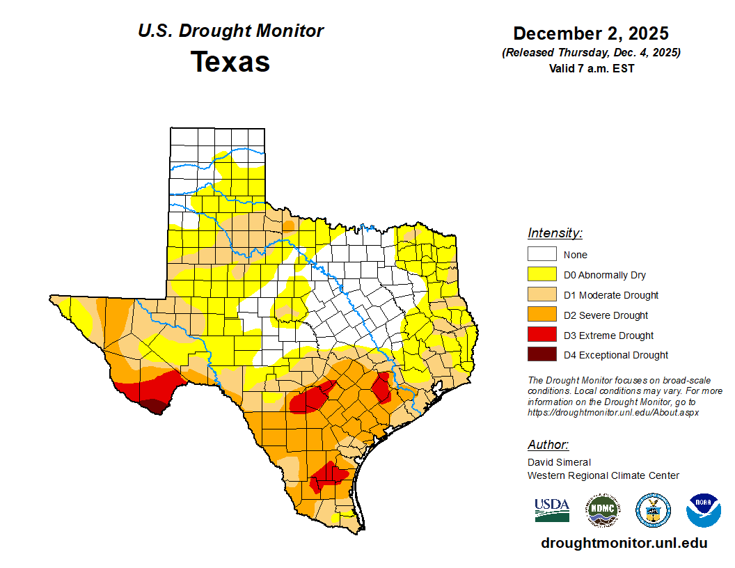
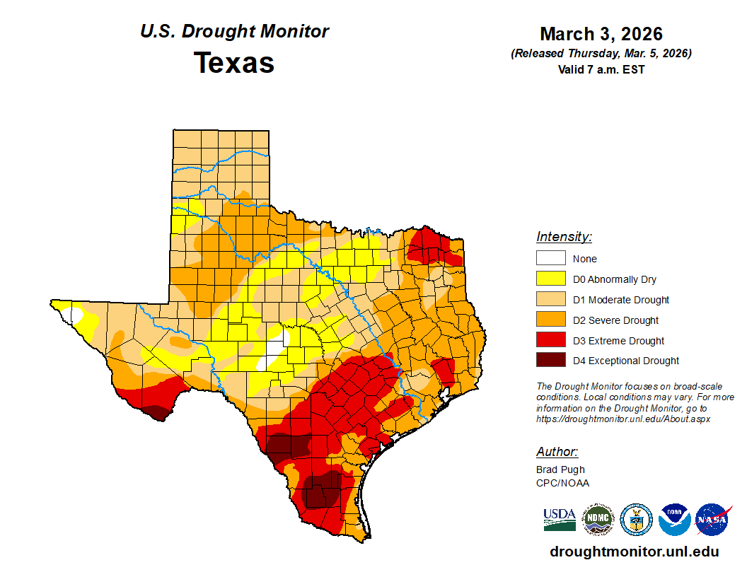
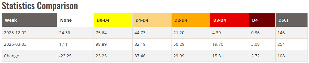
| (top left) Drought monitor valid on December 2, 2025. (top right) Drought monitor valid on March 3, 2026. (bottom) Stats comparison between the drought conditions in early December 2025 and early March 2026. | |
| Over the course of the winter, abnormally dry (D0) to moderate drought (D1) conditions increased to severe drought (D2) for much of Rolling Plains and adjacent areas. The increasing and worsening drought wasn't confined to West Texas, but affected much of the state. The record warmth and persistent dry conditions continued into March, with many highs in the 80s and 90s. This included an all-time record high of 98˚F on March 21st and again on the 26th. | |

