 |
| About This Page |
| The severe weather guide serves to educate the public about hazardous weather and how to prepare for severe storms. |
|
|
 |
Severe Weather Awareness Week (March 1-7, 2026) |
 |
| |
|
The National Weather Service (NWS), in cooperation with the Arkansas Division of Emergency Management (ADEM), has proclaimed March 1 to March 7, 2026 as Severe Weather Awareness Week in Arkansas. Citizens of the state are urged to prepare for the severe weather season. People are encouraged to use the week to review severe weather safety rules, and to understand the hazards associated with severe thunderstorms.
|
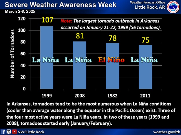 |
| In the picture: Tornadoes tend to be more frequent during the late winter/spring in Arkansas when La Niña (cooler than normal water along the equator in the Pacific Ocean) conditions exist. Three of the four most active years were La Niña years. |
|
| |
|
As of now, weak La Niña conditions are in place, meaning that water temperatures are a little cooler than normal along the equator in the Pacific Ocean. Research and local data indicate that tornadoes tend to be more frequent in Arkansas when La Niña is present. As the spring progresses, there should be a transition to neutral conditions (near normal water temperatures). Given this, the spring may not be overly active.
|
 |
| In the picture: The spring outlook from the Climate Prediction Center is leaning toward wetter than normal conditions from the Great Lakes and Ohio Valley into Arkansas. Drier than normal conditions are projected across portions of the West and Southwest. |
|
| |
|
While the thought of a less active spring is good news, it does not mean we will not experience significant severe weather. In 2017 (a year featuring neutral conditions), a line of storms swept from Oklahoma across the northern half of Arkansas. The line reached Fort Smith (Sebastian County) by 100 am CST, and made it to Blytheville (Mississippi County) by 430 am CST. That's roughly 250 miles in less than four hours! Along the way, trees and power lines were downed and structures were damaged or destroyed. Straight-line wind gusts reached 60 to more than 90 mph. Intense lines of storms like this sometimes produce brief and weak tornadoes. During this event, at least six weak tornadoes (rated EF0/EF1) were counted. Such an outbreak could occur this year, so we need to be ready!
|
| Notable Gusts at Automated Observation Sites (03/01/2017) |
| Site |
Gust |
Time |
| Walnut Ridge (Lawrence Co) |
76 mph |
335 am CST |
| Jonesboro (Craighead Co) |
68 mph |
350 am CST |
| Fort Smith (Sebastian Co) |
66 mph |
1252 am CST |
| Newport (Jackson Co) |
66 mph |
332 am CST |
| Blytheville (Mississippi Co) |
63 mph |
429 am CST |
| Flippin (Marion Co) |
59 mph |
235 am CST |
| Corning (Clay Co) |
58 mph |
355 am CST |
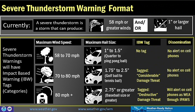 |
| In the picture: Impact based warning (IBW) tags went into effect in 2021. |
|
| |
|
When it becomes necessary for severe weather warnings, there is something to mention. As expected wind gusts and hail sizes increase, we want to get your attention. There will be little commotion surrounding a standard Severe Thunderstorm Warning (60 mph winds/one inch hail). However, if 70 to 80 mph gusts or golf ball to tennis ball size hail are in the warning, it will be tagged as a "considerable" damage threat. For 80+ mph gusts or 2.75+ inch (baseball or larger) size hail, the damage tag will be labeled as "destructive". This tag will result in the activation of a Wireless Emergency Alert (WEA) through the Integrated Public Alert and Warning System (IPAWS), and this will go to cell phones within the warning polygon.
To help you plan for severe weather, the NWS will broadcast safety information on NOAA Weather Radio (NWR) and will transmit Public Information Statements (PNS) on news and weather wires.
|
| Information Available During Severe Weather Awareness Week, 2026 |
| |
| Sunday, March 1, 2026...Introduction to Severe Weather Awareness Week...click here. |
| Monday, March 2, 2026...Flooding...click here. |
| Tuesday, March 3, 2026...Storm Prediction Center Outlook Changes...click here. |
| Wednesday, March 4, 2026...Tornadoes...click here. |
| Thursday, March 5, 2026...Severe Thunderstorms...click here. |
| Friday, March 6, 2026...Watches and Warnings...click here. |
| Saturday, March 7, 2026...Storm Reports...click here. |
| Severe Weather Awareness Week Slides |
|
|
| In the picture: Severe Weather Awareness Week overview slide. |
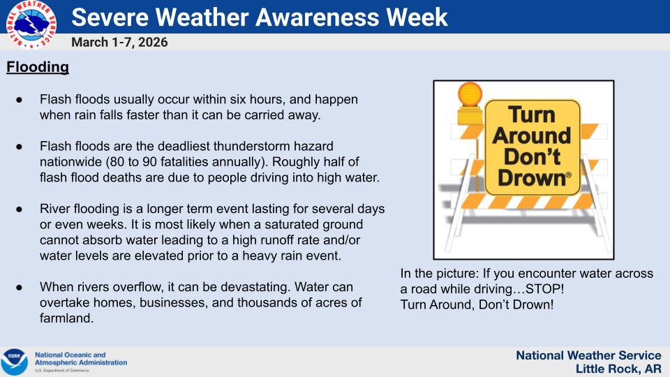
| In the picture: The topic for Monday is Flooding. |
| In the picture: The topic for Tuesday is Storm Prediction Outlook Changes. |
 |
| In the picture: The topic for Wednesday is Tornadoes. |
 |
| In the picture: The topic for Thursday is Severe Thunderstorms. |
 |
| In the picture: The topic for Friday is Watches and Warnings. |
 |
| In the picture: The topic for Thursday is Severe Thunderstorms. |
 |
| This special week follows a year (2025) with 60 tornadoes (37 is normal). |
| |
| Link of Interest |
| Tornadoes in Arkansas Since 1950 |
| Note: The number of tornadoes has doubled since the WSR-88D (Doppler Weather Radar) was installed in the early 1990s (39 tornadoes per year post Doppler versus 19 tornadoes pre Doppler). This is mainly due to better detection of rotation, especially with small/weak tornadoes. |
|
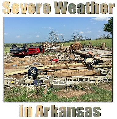
| In the picture: This is the cover of the "Severe Weather in Arkansas" guide featuring a home destroyed by a tornado (rated EF3) near Olvey (Boone County) early on 05/26/2024. |
| The busiest month of the year was April with twenty one tornadoes. The strongest tornadoes in 2025 were rated EF4, and there were two of them. Both of these occurred on March 14th and caused at least 6 injuries with thankfully no deaths. One of them had a path length of just over 117 miles. |
| Link of Interest |
| Severe Weather in Arkansas |
| Note: This includes a question/answer guide, tornado statistics since 1950, and severe weather terminology. |
|
When severe weather threatens, don't forget to follow the National Weather Service through social media platforms such as Facebook and Twitter.
|
|
| In the picture: The National Weather Service in Little Rock uses social media on a daily basis for to raise awareness of life-threatening weather, and distributing forecast and climate information, education, and outreach. |
 |
When spring unleashes monster storms, are you ready? Make a plan with just a few simple steps: Know Your Risk, Take Action and Be a Force of Nature. |
| In the picture: This is the Weather Safety Spring logo, and is a reminder to prepare now for severe weather. |
|
|