National Weather Service United States Department of Commerce

Active Pattern for the Center of the Nation

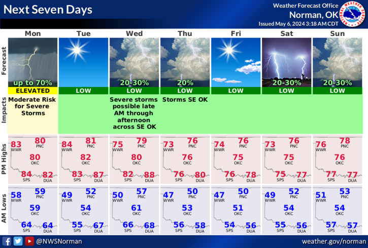
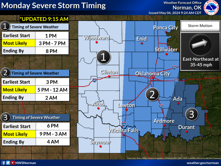
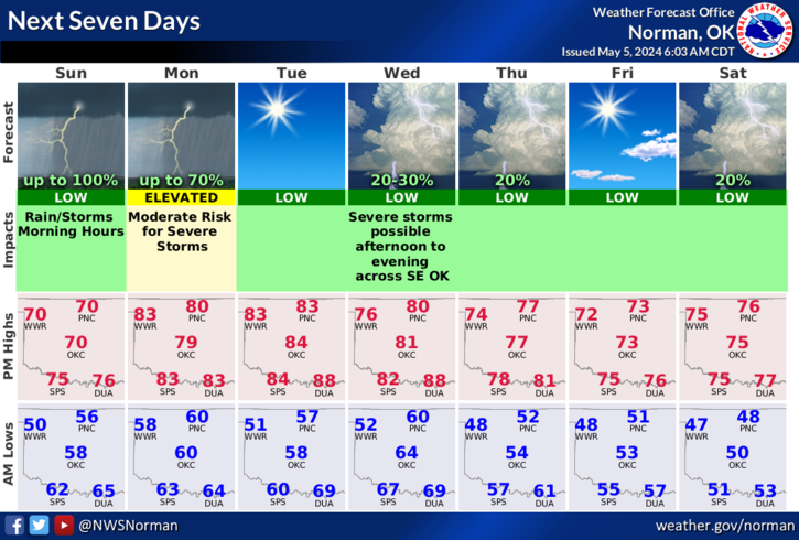
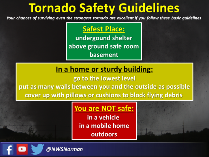
Critical fire weather conditions, severe thunderstorms capable of producing severe wind gusts, large hail, strong tornadoes and heavy rainfall remain on tap for the central U.S. this evening. Flash flooding is also possible for portions of the Plains and Mississippi Valley. Very large hail up to 3 inches in diameter will be possible this evening across western Kansas. Read More >

Click a location below for detailed forecast.

Last Map Update: Fri, Apr. 26, 2024 at 2:44:18 am CDT

National Weather Service Dodge City, KSNational Weather Service Wichita, KansasNational Weather Service Tulsa, OK
National Weather Service Amarillo, TXZoom
Out

National Weather Service Tulsa, OK
National Weather Service Lubbock, TXNational Weather Service Fort Worth/Dallas, TXNational Weather Service Shreveport, LA

Storms are expected to form in west Texas late tonight and spread east into Oklahoma and north Texas during the overnight hours. The main threat will be damaging winds, but there is the potential of large hail and tornadoes as well.
Storms are likely to begin around midnight in western north Texas and spread eastward across much of Oklahoma and western north Texas overnight.
There is an enhanced risk of severe thunderstorms across a large portion of Oklahoma and north central Texas on Saturday, with at least a slight risk over the entire area on Saturday. Damaging wind gusts, large to very large hail and tornadoes are all possible. The primary time of severe weather potential would be from Noon through the overnight hours until sunrise Sunday morning.
A few severe thunderstorms are possible by Sunday afternoon into evening. Uncertainty in coverage and location remains, so check back!

 Current Weather Observations...
Location Time
(CDT)
Weather Vsby.
(SM)
Temp.
(ºF)
Dewpt.
(ºF)
Hum.
(%)
Wind
(mph)
Wind Chill / Heat Index
(ºF)
Pres.
(in)
Oklahoma City, OK01:52Overcast9726784S 13G25-29.70
Norman, OK01:55Overcast10726782SSE 21G28-29.69
Stillwater, OK01:53Overcast10746778SSE 15G23-29.68
Lawton, OK01:53Overcast7736884SSE 10-29.69
Wichita Falls, TX01:52Overcast8746881S 14G21-29.67
Ponca City, OK01:53Mostly Cloudy10686693SSE 18G25-29.67
Enid, OK01:55Mostly Clear10726783SSE 17-29.63
Alva, OK02:15Overcast10736883S 20G26-29.59
Woodward, OK01:50Partly Cloudy10696277S 25G31-29.61
Gage, OK01:53Mostly Clear10716478S 28G44-29.58
Watonga, OK01:55Overcast10726784S 16-29.69
Clinton, OK01:53Overcast8706687S 20G33-29.67
Weatherford, OK02:15Mostly Cloudy10726682S 15G24-29.67
Hobart, OK01:53Mostly Cloudy7716890S 20-29.68
Altus, OK01:55Lightning Observed10696894S 12G18-29.69
Frederick, OK01:53Mist6726887SSW 7-29.67
Ardmore, OK01:55Light Rain8716994SSE 13-29.72
Ada, OK01:55Overcast10716888SSE 15G22-29.74

Local Weather History For April 26th...
One of the most significant tornado outbreaks over the Southern
Plains in recent memory occurred on April 26, 1991. A total of 55
tornadoes, including ten in Oklahoma, ravaged the area. The most
infamous of the storms struck the area around Andover and Wichita,
Kansas. In Andover, 17 people were killed and more than 225 injured.
The strongest storm in Oklahoma was the Red Rock tornado. This storm
began just east of Garber, in Garfield County, and traveled 66 miles
to just northwest of Pawhuska, in Osage County. Despite the violence
of this intense tornado, it injured only six people.

Text Product Selector (Selected product opens in current window)
Weather Observations Area Forecast Discussion Air Quality Forecasts Hydrology Information Frequently Asked Questions Social Media
Observations Discussion Air Quality Hydrology FAQ Social Media
 
Submit a Storm Report Graphical Weather Forecasts Aviation Weather Forecasts Climate Data Storm Data Weather Radio Information
Storm Reports Gridded Forecast Aviation Climate Storm Data Weather Radio  
 
Satellite Information Hourly Weather Forecast Fire Weather Information Past Weather Events StormReady Skywarn/Storm Spotters
Satellite Hourly Forecast Fire Weather Past Events StormReady Storm Spotters