
Flash flooding threatens areas from the Tennessee Valley to the Carolinas as storms repeat along a stalled front. Monsoonal storms may trigger flooding in the Southwest. Dangerous heat expands across the Desert Southwest, Plains, mid-Mississippi Valley and Southern Tier. Critical fire weather for interior Pacific Northwest. Cooler, drier air brings brief relief to the Great Lakes and Northeast. Read More >
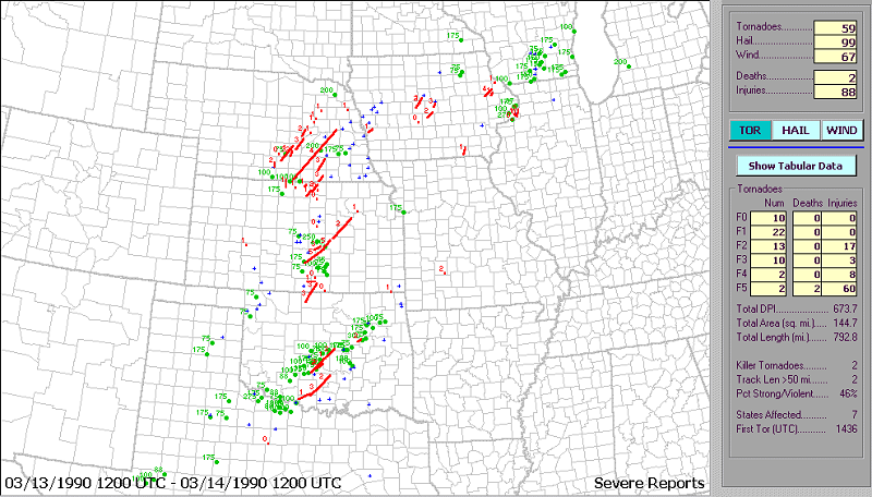
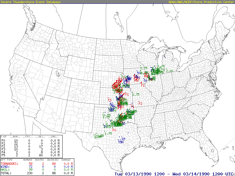
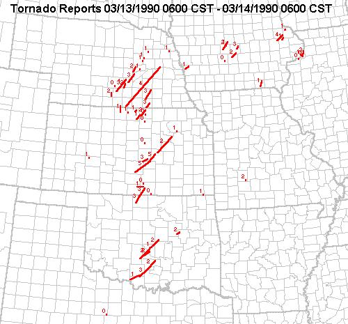 The mid to late 1980s marked a period with low annual tornado counts and mostly weak tornadoes occurring in the state of Oklahoma. However, a widespread outbreak of tornadoes in the central portion of the United States on March 13, 1990 marked the most significant tornado outbreak to occur in the state since 1984. Most of the tornadoes reported during this outbreak including the most violent tornadoes occurred in Iowa, Kansas and Nebraska. However, a total of ten tornadoes touched down in Oklahoma during the late afternoon and evening of March 13th.
Most of the tornadoes in Oklahoma were produced by three parent supercell thunderstorms. One of the supercells moved through central Oklahoma during the late afternoon and early evening of March 13th and dropped a total of four tornadoes. Areas in and around the town of Noble were impacted by two F2 tornadoes. One F1 tornado and another F2 tornado produced damage in and near Stella, OK.
The second supercell traveled through north central Oklahoma during the late afternoon and early evening of March 13th and dropped a total of two F3 tornadoes near Wakita, OK iin Grant County. The second tornado also moved from Oklahoma into south central Kansas during its lifetime.
A third supercell moved through south central Oklahoma during the late afternoon and early evening of March 13th and dropped a total of three tornadoes including a F3 tornado the produced damage in and near Ratliff City, OK while a F2 tornado tracked in and near Pauls Valley, OK.
At 6:00 PM CST on March 12th (0000 UTC 13 March), a strong ridge of high pressure was present across the southeastern United States, while an upper-level closed low and associated trough covered the western half of the country. The central plains were located in a rather tight pressure gradient between the approaching trough to the west and ridge to the east. The 850 mb plot showed low-level Gulf moisture streaming northward on a 35-knot low-level jet from southern Texas to Iowa. Southwesterly flow aloft and vorticity advection over the Rocky Mountains, as seen on the 500 mb analysis, provided favorable conditions for low-level lee cyclogenesis. Thermal ridging from western Texas northward into western Kansas at 850 mb was an indication of the developing cyclone. Surface analysis showed a pronounced dryline extending from western Kansas into western Texas, and a 1004 mb low in eastern Colorado. A stationary front was located along the Kansas-Nebraska border and a cold front was analyzed from southern Minnesota southwestward to central New Mexico. By 9:00 PM CST (0300 UTC), the primary area of surface moisture convergence was across south-central Oklahoma, and this area expanded northward by 12:00 AM CST (0600 UTC). The moisture axis extended from central Texas northward to central Kansas.
At 6:00 AM CST on March 13th (1200 UTC), temperatures were warming into the mid 60s just ahead of the dryline, in western Oklahoma and Kansas, as seen on the surface analysis. The first tornado watches of the day were issued from west-central Kansas southward into western Oklahoma. The low-level pressure gradient tightened across the central plains and wind speeds increased, as evident on the 925 mb analysis. The 1200 UTC soundings showed veering wind profiles and substantial speed shear across the entire region. A 50-knot low-level jet at 850 mb was present on the Amarillo, Topeka, and Dodge City soundings. The 250 mb and 300 mb analyses showed an upper-level difluence zone across southern Oklahoma and northern Texas. A cyclone with a central pressure of 1000mb moving into western Kansas and the Oklahoma panhandle was analyzed on the 9:00 AM CST (1500 UTC) surface analysis. The dryline remained clearly defined across western Kansas and Texas.
At 12:00 PM CST (1800 UTC), the surface cyclone had a central pressure of 998 mb and had deepened to 996 mb by 3:00 PM CST (2100 UTC). The increasing pressure gradient across western Kansas and Oklahoma amplified surface convergence near the low and along the dryline. Daytime turbulent mixing became sufficient to push the dryline into western Oklahoma by 3:00 PM CST, as temperatures rose into the low to mid 70s across western and central Oklahoma. A warm front was also evident from Minnesota southwestward into northwestern Kansas on the mid-afternoon surface analysis. The first tornadic supercells developed over west-central Oklahoma, as the dryline began to progress across the state. At 4:44 PM CST, the tornado outbreak was initiated by an F2 twister touching down in Grady County.
The 6:00 PM CST (0000 UTC 14 March) upper-air analysis showed a closed low across Utah, Wyoming, and Colorado. Cold mid-level temperatures were associated with the low, as seen in the 500 mb analysis, and were being advected into the western Kansas, Oklahoma, and Texas by strong, southwesterly winds from 700 mb to 500mb. This upper-level cooling steepened lapse rates seen on the Amarillo and Dodge City 0000 UTC soundings and further destabilized the atmosphere. The upper-level trough had progressed into the central plains, strengthening speed shear across the region. Both the 925 mb and 850 mb analyses showed ample moisture streaming northward from the Gulf of America into Texas, Oklahoma, and Kansas. The 925 mb winds at 0000 UTC across Texas and Oklahoma backed to southeasterly, allowing for enhanced low-level convergence along the dryline. Surface analysis showed the cyclone had moved northeasterly to the central Kansas-Nebraska border. By about 6:00 PM CST, 7 tornadoes had been reported across the state of Oklahoma.
At 9:00 PM CST (0300 UTC), the original area of surface low pressure had moved into eastern Nebraska, while a secondary cyclone formed across southwestern Texas. A cold front extended across the plains, between the two surface cyclones. By 12:00 AM CST on March 14th (0600 UTC), tornado watches covered eastern Kansas, nearly the entire body of Oklahoma, and parts of north Texas. Thunderstorms lined up from the Nebraska-Iowa border southward into central Texas. The 3:00 AM CST (0900 UTC) surface analysis showed a series of mesohighs and mesolows along the cold front across Kansas, central Oklahoma, and Texas. Reports of severe hail and strong thunderstorm winds continued until dawn across southern and eastern Oklahoma.
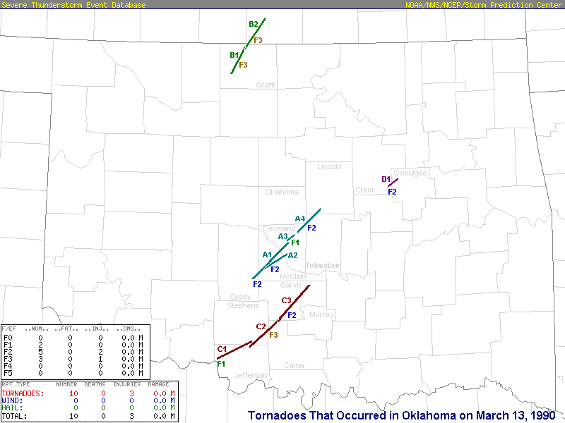
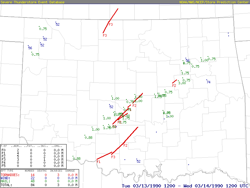
An outbreak of severe thunderstorms and tornadoes occurred during the afternoon and evening of the March 13th and early morning hours of the 14th. Many reports of large hail were received, some as large as softballs. Four supercell thunderstorms produced a total of ten tornadoes in the state of Oklahoma on March 13th. A summary of these tornadoes sorted by parent supercell thunderstorm follows. A letter has been assigned to each supercell, and is based on the touchdown time of the first tornado produced by the storm.
This parent supercell thunderstorm moved through central Oklahoma during the late afternoon and early evening of March 13th and dropped a total of four tornadoes.
Tornado A1 (rated F2) touched down at 4:44 PM CST 1 mile west of Bradley and moved northeast, dissipating 5 miles northeast of Noble at 5:37 PM CST. Near Bradley 2 mobile homes were destroyed, several homes were damaged, and 3 barns were damaged. In McClain County damage was intermittent from 5 miles west of Criner to Interstate 35 southeast of Goldsby. At least 8 mobile homes were destroyed and several outbuildings destroyed. In Washington, the second story of a home was destroyed.
There was one injury to a woman in a mobile home. In Noble, Cleveland County, damage was extensive. An apartment building lost part of its roof, and a mobile home was overturned. Several tractor-semitrailers were overturned at a warehouse. Numerous houses sustained roof and other structural damage in the Sky Ridge and Forest Hills subdivisions. The Noble High School stadium press box was destroyed, several light poles were snapped, and the scoreboard destroyed. Total damage was estimated between $750,000 and $1 million.
Tornado A2 (rated F2) touched down at 5:31 PM CST 2 miles west of Criner and followed a path very close to the first tornado, dissipating 5 miles southeast of Noble around 6:05 PM CST. Damage was intermittent and included mobile homes damaged just west of Criner, damage to outbuildings 3.5 miles south of Washington, and many uprooted trees.
Tornado A3 (rated F1) touched down at 5:53 PM CST and traveled a 5-mile path across Little River State Park in east Norman before lifting 4 miles southwest of Stella at apparoximately 6:03 PM CST. Damage was confined to downed trees and power lines.
Tornado A4 (rated F2) touched down at 5:59 PM CST 1 mile southwest of Stella and moved northeast, lifting 4 miles west of Meeker at 6:45 PM CST. A mobile home was destroyed in Stella, resulting in one serious injury. In Pottawatomie County, damage to the Shawnee Lakes area included the roof ripped off a home, several homes with minor structural damage, three mobile homes damaged, and a barn destroyed. In Lincoln County, a camper was rolled over onto a shed west of Meeker, and a mobile home 4.25 miles west of Meeker was destroyed. This tornado was classified as separate from Tornado A3, after close examination of Doppler radar radial velocity data.
This parent supercell thunderstorm moved through north central Oklahoma during the late afternoon and early evening of March 13th and dropped a total of two tornadoes. The second tornado moved from Oklahoma into south central Kansas during its lifetime.
Tornado B1 (rated F3) touched down at 5:15 PM CST 5 miles northeast of Nash and dissipated 7 miles northeast of Wakita at 5:55 PM CST. A home was severely damaged 4 miles east of Wakita, as was a nearby garage and several outbuildings.
Tornado B2 (rated F3) touched down at 5:54 PM CST 8 miles northeast of Wakita and moved northeast for 4 miles before crossing the Kansas state line 6.5 miles southwest of Caldwell, KS at approximately 6:05 PM CST. The traveled for an additional 18 miles before dissipating 3 miles southwest of Mayfield, KS at approximately 6:55 PM CST. Damage in Oklahoma consisted of snapped trees (F0 rating), while some damage in Kansas was rated up to F3 in intensity.
This parent supercell thunderstorm moved through south central Oklahoma during the late afternoon and early evening of March 13th and dropped a total of three tornadoes.
Tornado C1 touched down at 6:01 PM CST 5 miles west of Waurika and moved northeast, dissipating 3 miles southwest of Loco at 7:00 PM CST. Damage was confined to uprooted trees and the intensity was rated F1.
Tornado C2 (rated F3) touched down at 6:58 PM CST 5 miles south-southwest of Loco and moved northeast, dissipating 3 miles northeast of Ratliff City at 7:37 PM CST. Damage from just west of Ratliff City into town, included 5 destroyed mobile homes a motor home rolled 100 feet and destroyed, and severe damage to a gas compressor station. At the station, a large metal building and a mobile home were destroyed. A 5-ton crane was overturned, several vehicles were damaged, and debris was found over a mile northeast. There was one minor injury to a worker at the station. Total damage in the Ratliff City area is estimated at $500,000 to $750,000.
Tornado C3 (rated F2) touched down at 7:50 PM CST 8 miles south-southwest of Elmore City and dissipated 4miles southwest of Byers at 8:45 PM CST. Damage in Pauls Valley included the roof ripped off a farm implement company, damage to stock and other equipment inside the building, and the roof partially ripped off a nearby civic club building. Northeast of Pauls Valley, several barns were destroyed. Elsewhere along the path trees and power lines were downed.
This parent supercell thunderstorm moved through east central Oklahoma during the late afternoon and early evening of March 13th and produced one tornado.
Tornado D1 (rated F2) touched down 8:10 PM CST 6 miles southeast of Slick and moved east, intermittently touching down for nine miles, and lifting 3 miles northwest of Beggs at approximately 8:20 PM CST. Several hams were destroyed and 14 power poles were snapped. Total damage was estimated at $75,000.
In addition to tornadoes, damaging straight-line winds were also reported. A mobile home was destroyed in Newalla (Oklahoma County) during the evening of the March 13th. During the early morning hours of the 14th, there were many reports of wind damage: a mobile home was destroyed and a home unroofed 1 mile north of Wilson; a barn was destroyed 3 miles west of Latta; several buildings suffered roof damage in Prague; a barn and cart were destroyed near Spaulding; five buildings suffered roof or other structural damage in Wewoka; a roof was damaged and a porch destroyed 4 miles southeast of Holdenville a mobile home and storage shed were destroyed in Fort Gibson; homes were damaged in Muskogee; and structural damage occurred at two marinas on Grand Lake 2 miles east of Cleora. Large trees were downed just north of Grove where a roof was also ripped off, and large trees were uprooted 5 miles southeast of Fairfield. Lightning struck a home in Whiteoak and the resulting fire caused $80,000 in damage.
| Event # |
Event Tornado ID |
Date | Time (CST) |
Length of Path (miles) |
Width of Path (yards) |
F-Scale | Killed | Injured | State | County | Location |
|---|---|---|---|---|---|---|---|---|---|---|---|
| 1 | A1 | 03/13/1990 | 1644-1737 | 28 | 200 | F2 | 0 | 1 | OK | Grady/ McClain/ Cleveland | 1 W Bradley - Washington - Noble - 5 NE Noble |
| 2 | B1 | 03/13/1990 | 1715-1755 | 19 | 200 | F3 | 0 | 0 | OK | Grant | 5 NE Nash - 7 NE Wakita |
| 3 | A2 | 03/13/1990 | 1731-1805 | 18 | 150 | F2 | 0 | 0 | OK | McClain/ Cleveland | 2 W Criner - 5 SE Noble |
| 4 | A3 | 03/13/1990 | 1753-1803 | 5 | 50 | F1 | 0 | 0 | OK | Cleveland | Little River S.P. - 4 SW Stella |
| 5 | B2 | 03/13/1990 | 1754-1855 | 22 | 200 | F3 | 0 | 0 | OK/ KS | Grant/ Sumner | 8 NE Wakita OK - 7 WSW Caldwell KS - 3 SW Mayfield KS |
| 6 | A4 | 03/13/1990 | 1759-1845 | 19 | 200 | F2 | 0 | 1 | OK | Cleveland/ Pottwatomie/ Lincoln | 1 SW Stella - Stella - 4 W Meeker |
| 7 | C1 | 03/13/1990 | 1801-1900 | 21 | 73 | F1 | 0 | 0 | OK | Jefferson/ Stephens | 5 W Waurika - 3 SW Loco |
| 8 | C2 | 03/13/1990 | 1858-1937 | 22 | 200 | F3 | 0 | 1 | OK | Jefferson/ Stephens/ Carter | 5 SSW Loco - Ratliff City - 3 NE Ratliff City |
| 9 | C3 | 03/13/1990 | 1950-2045 | 28 | 150 | F2 | 0 | 0 | OK | Garvin | 8 SSW Elmore City - Pauls Valley - 4 SW Byers |
| 10 | D1 | 03/13/1990 | 2010-2020 | 9 | 340 | F2 | 0 | 0 | OK | Creek/ Okmulgee | 6 SE Slick - 3 NW Beggs |
| Tornadoes by Intensity | |||||||
|---|---|---|---|---|---|---|---|
| State | F0 | F1 | F2 | F3 | F4 | F5 | Total |
| Iliinois | 0 | 0 | 0 | 1* | 0 | 0 | 1* |
| Iowa | 3 | 6 | 2 | 2* | 1 | 0 | 14* |
| Kansas | 5 | 8 | 2 | 2^ | 0 | 2 | 19^ |
| Missouri | 0 | 0 | 1 | 0 | 0 | 0 | 1 |
| Nebraska | 1 | 6 | 3 | 4 | 1 | 0 | 15 |
| Oklahoma | 0 | 2 | 5 | 3^ | 0 | 0 | 10^ |
| Texas | 1 | 0 | 0 | 0 | 0 | 0 | 1 |
| Event | 10 | 22 | 13 | 10 | 2 | 2 | 59 |
|
*An F3 tornado initiated in Iowa, but crossed the state line and dissipated in Illinois. Thus, two of the F3 tornadoes listed by state are not included in the event totals. |
|||||||
| Event # |
SPC # |
Date | Time (CST) |
Length of Path (miles) |
Width of Path (yards) |
F-Scale | Killed | Injured | State | County | Location |
|---|---|---|---|---|---|---|---|---|---|---|---|
| 1 | 77 | 03/13/1990 | 0836 | 1 | 25 | F1 | 0 | 0 | KS | Hodgeman | 10 NW Jetmore |
| 2 | 78 | 03/13/1990 | 1532-1550 | 14 | 25 | F1 | 0 | 0 | IA | Davis | 6 SSE - 9 NE Bloomfield |
| 3 | 79 | 03/13/1990 | 1631 | 0.3 | 50 | F0 | 0 | 0 | IA | Scott | 1 SE Riverdale |
| 4 | 80 | 03/13/1990 | 1634-1735 | 48 | 1320 | F5 | 1 | 60 | KS | Reno/ Harvey/ McPherson | 1 S Pretty Prairie - 8 SW Burrton - Hesston - 3 NE Hesston |
| 5 | 81 | 03/13/1990 | 1642-1643 | 0.2 | 75 | F0 | 0 | 0 | IA | Scott | Near Lock and Dam 14 |
| 6 | 82 | 03/13/1990 | 1644 | 28 | 200 | F2 | 0 | 1 | OK | Grady/ McClain/ Cleveland | 1 W Bradley - Washington - Noble - 5 NE Noble |
| 7 | 83 | 03/13/1990 | 1645-1715 | 15.5 | 250 | F3 | 0 | 1 | IA/ IL | Scott/ Whiteside | Le Claire - Port Byron - Cordova - 1 SE Albany |
| 8 | 84 | 03/13/1990 | 1645 | 1 | 80 | F1 | 0 | 0 | NE | Buffalo | 2 NW Shelton |
| 9 | 85 | 03/13/1990 | 1648 | 13 | 220 | F1 | 0 | 0 | KS | Smith | 3 SE - 2 N Smith Center |
| 10 | 86 | 03/13/1990 | 1653-1725 | 19 | 200 | F4 | 0 | 0 | IA | Linn/ Jones/ Dubuque/ Delaware | Prairieburg - Worthington |
| 11 | 87 | 03/13/1990 | 1655-1715 | 13 | 75 | F1 | 0 | 0 | IA | Scott/ Clinton | 1 W Le Claire - 1 SW Camanche |
| 12 | 88 | 03/13/1990 | 1700-1730 | 32 | 200 | F3 | 0 | 0 | NE | Kearney/ Buffalo/ Hall | 3 NW Minden - 7 SW Shelton - 6 WSW Wood River - 2 S Cairo |
| 13 | 89 | 03/13/1990 | 1700 | 1.5 | 100 | F1 | 0 | 0 | KS | Jewell | 1.5 NE Esborn |
| 14 | 90 | 03/13/1990 | 1705-2010 | 131 | 440 | F4 | 0 | 8 | NE | Webster/ Nuckolls/ Clay/ Fillmore/ York/ Seward/ Butler/ Colfax | 3 S Red Cloud - 1 SW Lawrence - 2 WSW Deweese - 6 W Grafton - 2 SSW Lushton - 11 WNW Staplehurst - 6 WSW Ulysses -2.4 SW Schulyler - 3 E Schuyler (probable tornado family) |
| 15 | 91 | 03/13/1990 | 1708-1717 | 6 | 30 | F1 | 0 | 0 | IA | Jones | Monticello - 6 NE Monticello |
| 16 | 92 | 03/13/1990 | 1710-1727 | 8 | 40 | F1 | 0 | 0 | IA | Pottawatomie | 7 W - 5 N Underwood |
| 17 | 93 | 03/13/1990 | 1715 | 19 | 200 | F3 | 0 | 0 | OK | Grant | 5 NE Nash - 7 NE Wakita |
| 18 | 94 | 03/13/1990 | 1720 | 8 | 100 | F2 | 0 | 0 | NE | Kearney | 1 S - 7 N Wilcox |
| 19 | 95 | 03/13/1990 | 1725 | 9 | 80 | F2 | 0 | 0 | NE | Adams/ Hall | 4 W Prosser - Wood River |
| 20 | 96 | 03/13/1990 | 1730-1731 | 0.2 | 10 | F0 | 0 | 0 | TX | Throckmorton | 15 SE Throckmorton |
| 21 | 97 | 03/13/1990 | 1730-1758 | 22 | 1320 | F5 | 1 | 0 | KS | Harvey/ McPherson/ Marion | 1 N Hesston - Marion Reservoir |
| 22 | 98 | 03/13/1990 | 1731 | 18 | 150 | F2 | 0 | 0 | OK | McClain/ Cleveland | 2 W Criner - 5 SE Noble |
| 23 | 99 | 03/13/1990 | 1735 | 0.1 | 40 | F0 | 0 | 0 | NE | Buffalo | 2 N Kearney |
| 24 | 100 | 03/13/1990 | 1744-1825 | 27 | 200 | F3 | 0 | 0 | NE | Hall/ Howard/ Merrick | 1 N Alda - 2.5 SSE St. Libory - 1 WNW Worms - 3 SE Palmer |
| 25 | 101 | 03/13/1990 | 1753 | 5 | 50 | F1 | 0 | 0 | OK | Cleveland | Little River S.P. - 4 SW Stella |
| 26 | 102 | 03/13/1990 | 1754-1805 | 22 | 200 | F3 | 0 | 0 | OK/ KS | Grant/ Sumner | 8 NE Wakita OK - 7 WSW Caldwell KS - 3 SW Mayfield KS |
| 27 | 103 | 03/13/1990 | 1755-1800 | 3 | 25 | F1 | 0 | 0 | IA | Dubuque | 7 NE Dyersville - Holy Cross |
| 28 | 104 | 03/13/1990 | 1759-1845 | 19 | 200 | F2 | 0 | 1 | OK | Cleveland/ Pottwatomie/ Lincoln | 1 SW Stella - Stella - 4 W Meeker |
| 29 | 105 | 03/13/1990 | 1801-1900 | 21 | 75 | F1 | 0 | 0 | OK | Jefferson/ Stephens | 5 W Waurika - 3 SW Loco |
| 30 | 106 | 03/13/1990 | 1804 | 0.1 | 50 | F0 | 0 | 0 | KS | Sumner | 3 E South Haven |
| 31 | 107 | 03/13/1990 | 1812 | 0.1 | 50 | F0 | 0 | 0 | KS | Sumner | Conway Springs - 4 N Danville |
| 32 | 108 | 03/13/1990 | 1815 | 55 | 220 | F2 | 0 | 0 | KS | Marion/ Morris/ Geary/ Wabaunsee | 2 W Pilsen - 1 E Lost Springs - Dwight - 4 NE Dwight - 3 N Alta Vista - 8 W Alma |
| 33 | 109 | 03/13/1990 | 1820 | 5 | 440 | F1 | 0 | 0 | KS | Jewell | 2 S Lovewell Lake - near Webber |
| 34 | 110 | 03/13/1990 | 1823-1835 | 13 | 100 | F2 | 0 | 0 | NE | Merrick/ Nance | 2 NW Palmer - 5 SW Belgrade |
| 35 | 111 | 03/13/1990 | 1825 | 1.5 | 200 | F1 | 0 | 0 | NE | Boone | 8 ESE Albion - 7 E Albion |
| 36 | 112 | 03/13/1990 | 1830 | 2 | 50 | F1 | 0 | 0 | NE | Nance | 2 SE - 3 E Fullerton |
| 37 | 113 | 03/13/1990 | 1835 | 12 | 50 | F1 | 0 | 0 | KS | Harper | 1 N Danville |
| 38 | 114 | 03/13/1990 | 1845 | 0.2 | 50 | F1 | 0 | 0 | NE | Madison | 2 SE Battle Creek |
| 39 | 115 | 03/13/1990 | 1845 | 13 | 550 | F1 | 0 | 0 | KS | Jewell/ Cloud/ Republic | 1.5 SE Randall - 2 S Courtland |
| 40 | 116 | 03/13/1990 | 1855 | 18 | 200 | F3 | 0 | 0 | KS | Reno/ Harvey/ McPherson | 10 NW Burrton - 13 S McPherson |
| 41 | 117 | 03/13/1990 | 1858-1937 | 22 | 200 | F3 | 0 | 1 | OK | Jefferson/ Stephens/ Carter | 5 SSW Loco - Ratliff City - 3 NE Ratliff City |
| 42 | 118 | 03/13/1990 | 1900 | 15 | 440 | F2 | 0 | 0 | KS | Republic | 1 NE Kackley - 8 E Republic |
| 43 | 119 | 03/13/1990 | 1916 | 0.5 | 10 | F0 | 0 | 0 | KS | Republic | 2.5 S Belleville |
| 44 | 120 | 03/13/1990 | 1920 | 0.1 | 15 | F0 | 0 | 0 | IA | Dallas | Near Waukee |
| 45 | 121 | 03/13/1990 | 1925-2002 | 22 | 50 | F2 | 0 | 0 | IA | Boone/ Hamilton | Ogden - 2 NE Stanhope |
| 46 | 122 | 03/13/1990 | 1930-1940 | 0.6 | 75 | F1 | 0 | 0 | NE | Madison | 2 SE Battle Creek - Norfolk |
| 47 | 123 | 03/13/1990 | 1935 | 1 | 30 | F1 | 0 | 0 | IA | Boone | 8 N Boone |
| 48 | 124 | 03/13/1990 | 1945-2010 | 25 | 180 | F3 | 0 | 0 | NE | Thayer/ Fillmore | 1 N Carleton - 6 SE Shickley - 3 SE Exeter |
| 49 | 125 | 03/13/1990 | 1945 | 13 | 150 | F3 | 0 | 0 | NE | Thayer | Chester - 5 E Hebron |
| 50 | 126 | 03/13/1990 | 1950-2045 | 28 | 150 | F2 | 0 | 0 | OK | Garvin | 8 SSW Elmore City - Pauls Valley - 4 SW Byers |
| 51 | 127 | 03/13/1990 | 1950 | 0.2 | 10 | F0 | 0 | 0 | KS | Saline | Salina Airport |
| 52 | 128 | 03/13/1990 | 1955-2018 | 15 | 60 | F2 | 0 | 15 | IA | Story | 4 NE Ankeny - Maxwell |
| 53 | 129 | 03/13/1990 | 2003 | 2 | 50 | F1 | 0 | 0 | KS | Pottawatomie | 4 E - 6 NE Wamego |
| 54 | 130 | 03/13/1990 | 2010 | 9 | 340 | F2 | 0 | 0 | OK | Creek/ Okmulgee | 6 SE Slick - 3 NW Beggs |
| 55 | 131 | 03/13/1990 | 2036-2052 | 9 | 100 | F3 | 0 | 1 | IA | Story | 3 W Colo - 2 S Zearing |
| 56 | 132 | 03/13/1990 | 2040 | 0.2 | 10 | F0 | 0 | 0 | KS | Cloud | 2.5 S Concordia |
| 57 | 133 | 03/13/1990 | 2130 | 2 | 600 | F2 | 0 | 0 | MO | Polk | 0.5 NW - 2 NE Pleasant Hope |
| 58 | 134 | 03/13/1990 | 2201 | 1.5 | 50 | F1 | 0 | 0 | NE | Thurston | 3 SW - 1.5 SW Rosalie |
| 59 | 135 | 03/14/1990 | 0045 | 2 | 50 | F1 | 0 | 0 | KS | Labette | Chetopa |
WOUS00 KMKC 141042
NSSFC TORNADO AND SEVERE THUNDERSTORM REPORTS
PRELIMINARY LIST - INTERNAL DISSEMINATION ONLY
FOR 06CST TUE MAR 13 1990 THRU 06CST WED MAR 14 1990
EVENT LOCATION REMARKS (CST)TIME
2 *TORN 10 NW JETMORE KS (29 N DDC) (WT# 068) 13/0845
RPTD BY LAW ENFORCEMENT IN JETMORE. DDC/TOR 381910005
28 *TORN 6 E BLOOMFIELD IA (25 SSE OTM) ( ----- ) 13/1540
NARROW PATH OF DMG FM JUST E OF BLOOMFIELD TO DSM/TOR 4075 9228
NE CRNR OF CO
205 *TORN 6 NE BLOOMFIELD IA (20 SSE OTM) ( ----- ) 13/1550
LINES DWN...BARNS BLWN OVR. DSM/LSR 4081 9231
49 *TORN 1 E BETTENDORF IA (5 N MLI) ( ----- ) 13/1631
TORNADO RPTD NR RIVERDALE PWR STATION. MLI/SVS 4153 9050
55 *TORN NR CASTLETON KS (14 SSW HUT) ( ----- ) 13/1634
ICT/TOR 3786 9796
58 *TORN 2 S HUTCHINSON KS (3 SW HUT) ( ----- ) 13/1635
CNK/TOR 3803 9791
111 *TORN 9 NE (MLI)QUAD CITY ARPT MOLINEIL ( ----- ) 13/1642
TORNADO NR LOCK/DAM 14. MLI/LSR 4155 9038
41 *TORN 3 N SHELTON NE (15 ENE EAR) (WT# 071) 13/1645
GRI/TOR 4083 9873
40 *TORN SMITH CENTER KS (59 SSW HSI) ( ----- ) 13/1648
TWO TORNADOES RPTD ON THE GROUND. CNK/TOR 3978 9878
42 *TORN WOOD RIVER NE (17 NNW HSI) (WT# 071) 13/1650
NMRS REPORTS OF TORNAODES. GRI/SVS 4081 9860
47 *TORN NE LINN CO IA (16 NNE CID) ( ----- ) 13/1655
DBQ/TOR 4208 9156
51 *TORN PORT BYRON IL (14 NE MLI) ( ----- ) 13/1655
SVRL RPTS OF FUNNELS AND TORNADOES. MLI/TOR 4161 9033
56 *TORN DIBBLE OK (25 S OKC) (WT# 072) 13/1655
OKC/SVS 3503 9763
57 *TORN MCCLAIN CO OK (25 SE OKC) (WT# 072) 13/1655
TORNADO RPTD IN CRINER. OKC/SVS 3511 9730
52 *TORN 13 NE (MLI)QUAD CITY ARPT MOLINEIL ( ----- ) 13/1657
TORNADO RPTD AT LE CLAIRE. MLI/TOR 4160 9031
44 *TORN 1 SW RED CLOUD NE (36 S HSI) (WT# 071) 13/1659
GRI/TOR 4008 9855
59 *TORN 4 N HAVEN KS (8 SSE HUT) ( ----- ) 13/1700
LRG TORNADO RPTD. ICT/SVS 3796 9778
48 *TORN 3 W MONTICELLO IA (30 WSW DBQ) ( ----- ) 13/1703
2 HOMES DESTROYED...13 HOMES DMGD. DBQ/TOR 4223 9126
83 *TORN 3 S DIBBLE OK (28 S OKC) (WT# 072) 13/1704
OKC/LSR 3498 9763
113 *TORN 2 N CORDOVA IL (20 NNE MLI) ( ----- ) 13/1705
MLI/LSR 4171 9031
114 *TORN NR HILLSDALE IL (20 ENE MLI) ( ----- ) 13/1705
MLI/LSR 4161 9016
65 *TORN 1 SW COMANCHE IA (24 NNE MLI) ( ----- ) 13/1715
MLI/SVS 4176 9028
66 *TORN ALBANY IL (27 NNE MLI) ( ----- ) 13/1715
MLI/SVS 4178 9021
75 *TORN 2 E BURRTON KS (14 ESE HUT) ( ----- ) 13/1718
LRG TORNADO RPTD. ICT/SVS 3801 9761
63 *TORN HOPKINTON IA (27 W DBQ) ( ----- ) 13/1720
DBQ/TOR 4235 9125
204 *TORN NR WORTHINGTON IA (20 W DBQ) ( ----- ) 13/1720
EXCESSIVE DMG. 2500 GAL TANK TIPPED OVR. DBQ/LSR 4240 9111
62 *TORN 15 SE THROCKMORTON TX (54 WNW MWL) ( ----- ) 13/1730
ABI/TOR 3300 9896
72 *TORN 5 S DIBBLE OK (31 S OKC) (WT# 072) 13/1730
OKC/TOR 3494 9763
207 *TORN HESSTON KS (24 E HUT) ( ----- ) 13/1730
1 DEAD TOP/LSR 3813 9743
67 *TORN 10 N NEWTON KS (29 ENE HUT) ( ----- ) 13/1743
LRG DESTRUCTIVE TORNADO ON GROUND. ICT/TOR 3821 9735
68 *TORN 2 W MEDFORD OK (33 NNE END) (WT# 072) 13/1743
DMG RPTD. OKC/SVS 3681 9776
60 *TORN NW GRAND IS NE (3 SSW GRI) (WT# 071) 13/1744
RAILROAD CARS...TREES AND PWR POLES BLOWN DWN. GRI/SVS 4091 9835
138 *TORN 5 WNW (GRI)GRAND IS RGNL ARPT NE (WT# 071) 13/1744
GRI/SAO 4100 9841
69 *TORN GOESSEL KS (30 ENE HUT) ( ----- ) 13/1745
THREE TORNADOES ON THE GROUND E OF I135. CNK/SVS 3825 9735
212 *TORN 2 NW GRAND IS NE (4 SW GRI) (WT# 071) 13/1745
HOME AND GARAGE BLWN OFF FOUNDATION S OF GRI/LSR 4093 9838
TAYLOR RANCH.
105 *TORN 2 NW NEWCASTLE TX (51 NW MWL) ( ----- ) 13/1749
SPS/LSR 3321 9878
74 *TORN 5 E WAKITA OK (37 N END) (WT# 072) 13/1755
LRG TORNADO CAUSED SIGNIFICANT DMG. OKC/SVS 3688 9781
179 *TORN MCCLAIN CO OK (25 SE OKC) (WT# 072) 13/1755
BARN DSTRYD. OKC/LSR 3511 9730
61 *TORN CAIRO NE (14 W GRI) (WT# 071) 13/1800
TIME ESTD. $GRI/SVS 4100 9860
208 *TORN LAWRENCE NE (22 SSE HSI) (WT# 071) 13/1800
2 INJ 4 HOMES DESTROYED...10 DMGD. TIME ESTD. $GRI/LSR 4030 9826
73 *TORN 5 W WAURIKA OK (26 ENE SPS) (WT# 072) 13/1801
OKC/TOR 3416 9810
70 *TORN 1 E SOUTH HAVEN KS (27 NW PNC) ( ----- ) 13/1805
ICT/SVS 3705 9738
71 *TORN 1 S HILLSBORO KS (40 SE SLN) ( ----- ) 13/1805
ICT/SVS 3833 9720
97 *TORN 5 NE WAURIKA OK (36 ENE SPS) (WT# 072) 13/1830
OKC/LSR 3423 9793
209 *TORN SUTTON NE (30 E HSI) ( ----- ) 13/1830
HOMES AND BLDGS GONE. AMMONIA TANK DMGD. GRI/LSR 4060 9785
157 *TORN 5 W PERTH KS (34 SSW ICT) ( ----- ) 13/1832
ICT/TOR 3716 9760
210 *TORN 4 W MC COOL JCT NE (37 ESE GRI) ( ----- ) 13/1835
FARM DMGD. GRI/LSR 4075 9766
160 *TORN NR WEBBER KS (33 NW CNK) ( ----- ) 13/1843
CNK/TOR 3993 9803
167 *TORN NR BURDICK KS (38 WNW EMP) ( ----- ) 13/1849
TOP/SVS 3856 9683
159 *TORN 1 W JAMESTOWN KS (12 WNW CNK) ( ----- ) 13/1852
CNK/TOR 3960 9788
162 *TORN NR BUHLER KS (7 NE HUT) ( ----- ) 13/1854
TORNADO BTWN BURTON AND BUHLER. ICT/TOR 3813 9776
158 *TORN 20 S JUNCTION CITY KS (30 SSW MHK) ( ----- ) 13/1855
TOP/TOR 3869 9683
211 *TORN 9 W FULLERTON NE (28 NNE GRI) ( ----- ) 13/1855
FARM DMGD. GRI/LSR 4136 9818
165 *TORN NR INMAN KS (12 NNE HUT) ( ----- ) 13/1858
CNK/TOR 3823 9776
164 *TORN RANDALL KS (22 WNW CNK) ( ----- ) 13/1900
CNK/TOR 3963 9805
168 *TORN 7 SW WHITE CITY KS (29 SSW MHK) ( ----- ) 13/1900
TOP/SVS 3871 9683
161 *TORN 3 S SALINA KS (2 ESE SLN) ( ----- ) 13/1914
CNK/TOR 3878 9760
143 *TORN WAUKEE IA (13 WNW DSM) ( ----- ) 13/1920
DSM/LSR 4161 9390
182 *TORN ERN STEPHENS CO OK (32 ESE FSI) (WT# 072) 13/1927
OKC/LSR 3446 9786
183 *TORN WRN CARTER CO OK (13 W ADM) (WT# 072) 13/1927
RPTD ON CARTER/STEPHENS COUNTY LINE. OKC/LSR 3430 9725
144 *TORN OGDEN IA (36 SSE FOD) ( ----- ) 13/1930
DSM/LSR 4203 9403
145 *TORN RIDGEPORT IA (29 SSE FOD) ( ----- ) 13/1930
ROOFS BLOWN OFF...OUTBLDGS DMGD...LIVESTOCK DSM/LSR 4218 9391
DSTRYD.
174 *TORN DAVID CITY NE (17 SE OLU) ( ----- ) 13/1930
VEHICLES TURNED OVR...SOME STRUCTURAL DMG. LNK/LSR 4125 9713
175 *TORN NR BATTLE CREEK NE (8 W OFK) ( ----- ) 13/1930
CARS BLOWN OFF RD. OFK/SVR 4200 9760
146 *TORN 1 S STRATFORD IA (24 SSE FOD) ( ----- ) 13/1940
FARM DMGD. DSM/LSR 4225 9393
206 *TORN 4 S STRATFORD IA (27 SSE FOD) ( ----- ) 13/1940
DMG TO FARM. DSM/SVS 4220 9393
184 *TORN 8 SW ELMORE CITY OK (31 WNW ADM) (WT# 072) 13/1952
OKC/LSR 3451 9750
185 *TORN 3 SW ELMORE CITY OK (30 NW ADM) (WT# 072) 13/1955
OKC/LSR 3458 9743
156 *TORN HUSCHER KS (3 SE CNK) ( ----- ) 13/1956
CNK/TOR 3951 9760
178 *TORN NR SCANDIA KS (18 NNW CNK) ( ----- ) 13/2000
CNK/TOR 3980 9778
147 *TORN 1 E ANKENY IA (14 NNE DSM) ( ----- ) 13/2003
HOUSES DMGD...CARS BLOWN OFF HWY. DSM/LSR 4173 9360
100 *TORN 3 S ELMORE CITY OK (27 NW ADM) ( ----- ) 13/2006
OKC/LSR 3456 9738
155 *TORN 3 E SCHUYLER NE (18 E OLU) ( ----- ) 13/2015
PWR LNS DWN BY POSSIBLE TORNADO. OFK/SVS 4145 9700
203 *TORN NR ELKHART IA (18 NNE DSM) ( ----- ) 13/2024
DSM/TOR 4178 9353
148 *TORN ROSALIE NE (25 SSW SUX) ( ----- ) 13/2201
SUX/LSR 4205 9651
154 *TORN FT RILEY KS (7 SW MHK) ( ----- ) 13/2204
TOP/TOR 3905 9676
151 *TORN 2 SW RILEY KS (14 NW MHK) ( ----- ) 13/2225
TOP/SVS 3928 9686
20 A 75 GROOM TX (34 E AMA) ( ----- ) 13/0630
AMA/LSR 351910110
1 A 75 PAMPA TX (47 ENE AMA) ( ----- ) 13/0645
AMA/LSR 355310096
4 WNDG 1 SSE MIAMI TX (64 SW GAG) (WT# 069) 13/0730
DAMGE TO BARN. AMA/LSR 356810063
3 G 56 11 N SHATTUCK OK (12 NNW GAG) (WT# 069) 13/0825
GUSTS OF 60-70 MPH AND NMRS POWER OUTAGES. OKC/LSRS 3644 9988
8 WNDG MAY OK (21 N GAG) (WT# 069) 13/0830
MOBILE HOME AND LIVESTOCK SHED DMGD BY STG OKC/LSR 3661 9973
WINDS.
9 A 75 GAGE ARPT OK (GAG) (WT# 069) 13/0831
OKC/LSR 3630 9978
10 A 75 BUFFALO OK (37 NNE GAG) (WT# 069) 13/0844
OKC/LSR 3683 9961
11 G 52 11 NNW FREEDOM OK (42 SW P28) (WT# 069) 13/0850
OKC/LSR 3693 9920
12 G 52 NR FT SUPPLY LAKE OK (19 NE GAG) (WT# 069) 13/0855
OKC/LSR 3653 9956
13 A 75 12 NNW WOODWARD OK (26 NE GAG) (WT# 069) 13/0900
OKC/LSR 3661 9950
14 G 52 12 NNW WOODWARD OK (26 NE GAG) (WT# 069) 13/0900
OKC/LSR 3661 9950
5 G 51 (RSL)RUSSELL MUNI ARPT KS (WT# 068) 13/0950
RSL/SAO 3886 9881
7 A175 NR COLETA IL (41 WSW RFD) ( ----- ) 13/1005
RFD/SVR 4190 8980
6 G 50 (RSL)RUSSELL MUNI ARPT KS (WT# 070) 13/1010
RSL/SAO 3886 9881
15 G 52 TURON KS (35 NNE P28) (WT# 070) 13/1030
WIND ESTD BY SPOTTER. ICT/SPS 3780 9843
17 G 52 LYONS KS (26 NW HUT) (WT# 070) 13/1100
CNK/LSR 3835 9820
18 WNDG N SALINE CO KS (4 SSE SLN) (WT# 070) 13/1145
WOODEN SHED BLOWN APART. CNK/LSR 3873 9761
19 WNDG NR HADDAM KS (27 NE CNK) (WT# 070) 13/1212
WINDS DAMAGED SHED. CKN/LSR 3985 9730
16 A175 MAZON IL (15 SE MMO) ( ----- ) 13/1220
CHI/SVR 4123 8843
25 A175 LONG GROVE IA (18 NNW MLI) ( ----- ) 13/1330
MLI/SVR 4170 9060
24 A175 1 W ELVIRA IA (29 NNE MLI) ( ----- ) 13/1348
MLI/SVS 4186 9038
23 A100 NR SIX MILE IA (32 NNE MLI) ( ----- ) 13/1415
MLI/SVS 4190 9030
34 A100 NR STOCKTON IL (36 E DBQ) ( ----- ) 13/1415
TIME ESTD. $DBQ/SVS 4235 9000
116 A 75 2 N THOMSON IL (42 SE DBQ) ( ----- ) 13/1416
RFD/LSR 4200 9010
22 A 75 CARROLL CO IL (42 WSW RFD) ( ----- ) 13/1420
RFD/SVS 4206 8991
76 A 88 GRANDFIELD OK (20 NNW SPS) ( ----- ) 13/1438
OKC/LSR 3423 9868
77 A 75 5 W FREDERICK OK (20 SSE LTS) ( ----- ) 13/1440
OKC/LSR 3438 9911
128 A 75 RACINE CO WI (17 SSW MKE) ( ----- ) 13/1512
DIME SIZE HAIL RPTD ON HWY 11. MKE/LSR 4273 8806
21 A175 6 S LAWTON OK (9 S FSI) (WT# 072) 13/1515
OKC/SVS 3451 9840
26 WNDG GENOA IL (22 ESE RFD) ( ----- ) 13/1515
BARN AND TREES DMGD. CHI/SVR 4210 8868
117 WNDG MALTA IL (21 SSE RFD) ( ----- ) 13/1515
PWR LINES AND A BARN BLOWN DWN. RFD/LSR 4193 8886
27 A175 FREEPORT IL (27 WNW RFD) ( ----- ) 13/1525
RFD/SVR 4228 8961
120 A175 NR NEW GLARUS WI (26 SW MSN) ( ----- ) 13/1535
MSN/LSR 4281 8963
29 A 75 LENA IL (39 WNW RFD) ( ----- ) 13/1545
RFD/SVR 4238 8983
118 A 75 SHIRLAND IL (14 SW JVL) ( ----- ) 13/1545
RFD/LSR 4245 8920
30 A175 5 S MONROE WI (31 WSW JVL) ( ----- ) 13/1550
GOLFBALL HAIL CVRD THE GROUND. TIME ESTD. $MSN/SVR 4251 8963
78 A100 FLETCHER OK (14 NE FSI) (WT# 072) 13/1551
OKC/LSR 3481 9823
33 A175 E LAKE GENEVA WI (30 E JVL) ( ----- ) 13/1554
MKE/SVS 4260 8843
31 A100 3 S YUKON OK (9 WNW OKC) (WT# 072) 13/1557
OKC/SVR 3544 9775
79 A100 5 W RUSH SPGS OK (21 ENE FSI) (WT# 072) 13/1558
OKC/LSR 3478 9805
32 A175 2 S MILAN IL (4 WSW MLI) ( ----- ) 13/1605
MLI/SVS 4141 9056
37 A100 (MLI)QUAD CITY ARPT MOLINEIL ( ----- ) 13/1605
MLI/SAO 4145 9051
129 A175 BURLINGTON WI (26 SW MKE) ( ----- ) 13/1607
QUARTER TO GOLF BALL HAIL BTWN 1600 AND 1614 MKE/LSR 4266 8826
CST.
80 G 52 2 S RUSH SPGS OK (26 ENE FSI) (WT# 072) 13/1610
OKC/LSR 3475 9795
121 A 75 NR EDGERTON WI (14 N JVL) ( ----- ) 13/1610
MSN/LSR 4283 8906
119 A 75 WINSLOW IL (40 WSW JVL) ( ----- ) 13/1611
RFD/LSR 4250 8980
36 A175 WRN MILWAUKEE CO WI (5 NNW MKE) ( ----- ) 13/1615
GOLF BALL HAIL RPTD AT HWY 100 AND WATERTOWN MKE/SVR 4301 8795
PLANK RD.
115 A275 MOLINE IL (3 NNW MLI) ( ----- ) 13/1615
BASEBALL HAIL RPTD AT TV STATION. MLI/LSR 4150 9051
130 A175 WAUWATOSA WI (7 NNW MKE) ( ----- ) 13/1615
DIME SIZE HAIL RPTD. MKE/LSR 4305 8795
81 A175 4 N RUSH SPGS OK (29 ENE FSI) (WT# 072) 13/1616
QUARTER SIZE HAIL IN RUSH SPGS. OKC/LSR 3485 9795
54 A175 CEDAR KS (51 ENE HLC) ( ----- ) 13/1617
CNK/SVR 3964 9893
35 A175 NR PRETTY PRAIRIE KS (21 SSW HUT) ( ----- ) 13/1618
ICT/SVR 3778 9801
46 A 88 1 SE HOLLIDAY TX (17 SW SPS) (WT# 072) 13/1624
SPS/SVS 3378 9868
43 A 75 1 SW GIBBON NE (7 E EAR) (WT# 071) 13/1627
GRI/SVS 4073 9885
50 A175 1 E BETTENDORF IA (5 N MLI) ( ----- ) 13/1631
GOLFBALL HAIL NR THE ALCOA PLANT. MLI/SVS 4153 9050
122 A175 EDGERTON WI (14 N JVL) ( ----- ) 13/1633
MSN/LSR 4283 8906
45 A150 SW WICHITA FALLS TX (5 S SPS) (WT# 072) 13/1635
SPS/SVS 3390 9850
82 A 75 CRINER OK (29 S OKC) (WT# 072) 13/1636
OKC/LSR 3496 9756
39 A 75 FREDRICKSBURG IA (30 NNE ALO) ( ----- ) 13/1640
ALO/SVS 4296 9220
53 A175 N KINGMAN CO KS (30 NE P28) ( ----- ) 13/1640
ICT/SPS 3756 9813
123 WNDG NR BROOKLYN WI (19 S MSN) ( ----- ) 13/1640
HOUSE DSTRYD...PWR LNS DWN. MSN/LSR 4285 8936
102 A100 CLAY CO TX (19 SE SPS) (WT# 072) 13/1646
DIME HAIL RPTD SW OF DEAN. SPS/LSR 3380 9823
38 WNDG NR LINDSAY OK (39 S OKC) (WT# 072) 13/1647
TREES UPROOTED. OKC/LSR 3483 9760
112 A175 DAVENPORT IA (7 NW MLI) ( ----- ) 13/1647
MLI/LSR 4153 9058
103 A100 WICHITA FALLS TX (5 S SPS) (WT# 072) 13/1654
DIME SIZE HAIL RPTD AT SVRL PLACES IN WICHITA SPS/LSR 3390 9850
FALLS.
170 WNDG 6 NE COUNCIL BLUFFS IA (7 ENE OMA) (WT# 071) 13/1700
BARN DMGD. OMA/LSR 4133 9576
84 A100 CHICKASHA OK (31 SW OKC) (WT# 072) 13/1707
OKC/LSR 3505 9795
92 A175 2 SW BLANCHARD OK (20 SSW OKC) (WT# 072) 13/1710
OKC/LSR 3511 9770
124 WNDG ALBANY WI (21 WNW JVL) ( ----- ) 13/1710
TREES DWN. MSN/LSR 4270 8943
85 A 75 2 SW ALEX OK (36 SSW OKC) (WT# 072) 13/1713
OKC/LSR 3490 9780
171 WNDG 7 W UNDERWOOD IA (6 NNE OMA) (WT# 071) 13/1715
ROOFS OFF BARNS. TREE DMG. OMA/LSR 4138 9583
86 A 88 NORMAN OK (15 SSE OKC) (WT# 072) 13/1716
OKC/LSR 3521 9745
87 A 88 8 N ALEX OK (25 SSW OKC) (WT# 072) 13/1718
OKC/LSR 3505 9776
88 A100 3 S GOLDSBY OK (21 SSE OKC) (WT# 072) 13/1720
OKC/LSR 3510 9748
89 A 75 BLANCHARD OK (18 SSW OKC) (WT# 072) 13/1732
OKC/LSR 3513 9766
64 A100 NR HAZEL GREEN WI (17 ENE DBQ) ( ----- ) 13/1735
DBQ/SVR 4253 9043
104 A100 BYERS TX (19 ENE SPS) (WT# 072) 13/1735
SPS/LSR 3406 9818
125 A175 2 N STOUGHTON WI (13 SSE MSN) ( ----- ) 13/1735
MSN/LSR 4295 8921
90 A100 NORMAN OK (15 SSE OKC) (WT# 072) 13/1749
OKC/LSR 3521 9745
91 WNDG NOBLE OK (21 SSE OKC) (WT# 072) 13/1750
OKC/LSR 3513 9740
126 A 75 DANE CO WI (5 SW MSN) ( ----- ) 13/1755
DIME SIZE HAIL RPTD E OF BRISTOL. MSN/LSR 4306 8940
93 A100 SE OKLAHOMA CO OK (13 NE OKC) (WT# 072) 13/1756
OKC/LSR 3553 9741
94 A175 WAURIKA OK (31 ENE SPS) (WT# 072) 13/1803
OKC/LSR 3416 9800
95 WNDG N GRANT CO OK (31 NNE END) (WT# 072) 13/1805
HOME DSTRYD. OKC/LSR 3680 9780
106 A 88 IOWA PARK TX (9 WSW SPS) (WT# 072) 13/1808
OKC/LSR 3394 9866
96 WNDG NE CLEVELAND CO OK (20 SSE OKC) (WT# 072) 13/1810
PWR LNS DWN. OKC/LSR 3514 9741
136 A100 MILFORD WI (25 E MSN) ( ----- ) 13/1810
MKE/SVS 4310 8883
131 A175 WATERLOO WI (17 ENE MSN) ( ----- ) 13/1820
MKE/LSR 4318 8898
132 WNDG JUNEAU WI (36 ENE MSN) ( ----- ) 13/1820
TREE AND BARN DWN. MSN/LSR 4340 8870
127 G 50 DE FOREST WI (8 N MSN) ( ----- ) 13/1828
MARBLE SIZE HAIL ALSO RPTD. MSN/LSR 4325 8933
133 A 75 JUNEAU WI (36 ENE MSN) ( ----- ) 13/1835
MKE/LSR 4340 8870
98 A100 3 S MEEKER OK (39 E OKC) (WT# 072) 13/1847
OKC/LSR 3544 9690
99 A 75 2 S (TIK)TINKER AFB OKLAHOMA COK (WT# 072) 13/1849
OKC/LSR 3538 9738
107 A 75 KAMAY TX (20 WSW SPS) (WT# 072) 13/1850
NICKEL HAIL RPTD AT KADANE CORNER. SPS/LSR 3385 9881
137 A175 JUNEAU WI (36 ENE MSN) ( ----- ) 13/1908
MKE/SVS 4340 8870
181 A175 PRAGUE OK (51 E OKC) ( ----- ) 13/1913
OKC/LSR 3548 9668
101 A175 ROSCOE TX (49 W ABI) ( ----- ) 13/1915
ABI/SVR 324310053
108 A100 IOWA PARK TX (9 WSW SPS) (WT# 072) 13/1915
SPS/LSR 3394 9866
134 A175 DODGE CO WI (39 S OSH) ( ----- ) 13/1920
LARGER THAN GOLFBALL HAIL S MAYVILLE AND N MKE/LSR 4341 8865
IRON RIDGE.
180 A100 HARRAH OK (25 ENE OKC) (WT# 072) 13/1921
OKC/LSR 3548 9716
187 A175 6 W PADEN OK (51 E OKC) ( ----- ) 13/1930
TUL/LSR 3550 9668
213 WNDG RATLIFF CITY OK (29 WNW ADM) (WT# 072) 13/1945
MOBILE HOME OVRTRND...HOME DMGD...TREES AND OKC/LSR 3444 9750
PWR LNS DWN.
188 A 75 PADEN OK (58 E OKC) ( ----- ) 13/1949
TUL/LSR 3550 9656
186 A 75 ELMORE CITY OK (30 NW ADM) (WT# 072) 13/1959
OKC/LSR 3461 9738
189 A175 SLICK OK (35 SW TUL) ( ----- ) 13/2000
TUL/LSR 3578 9626
166 G 52 WAMEGO KS (19 ENE MHK) ( ----- ) 13/2005
TOP/SVS 3919 9631
190 A 75 5 NE BOLEY OK (53 SW TUL) ( ----- ) 13/2020
TUL/LSR 3556 9641
191 A 75 5 SE SLICK OK (37 SSW TUL) ( ----- ) 13/2020
TUL/LSR 3571 9620
192 G 61 NW OKMULGEE CO OK (31 S TUL) ( ----- ) 13/2025
MOB HOME DSTRYD AND ANOTHER DMGD. TUL/LSR 3575 9596
109 A275 LOCKETT TX (39 S LTS) ( ----- ) 13/2030
BASEBALL HAIL SVRLY DMGD A PICKUP TRUCK. SPS/LSR 3408 9936
177 WNDG NR CORDOVA NE (31 WSW LNK) ( ----- ) 13/2035
LNK/LSR 4071 9735
135 A100 SHEBOYGAN WI (26 S MTW) ( ----- ) 13/2045
MKE/LSR 4375 8771
110 A175 2 N VERNON TX (32 S LTS) ( ----- ) 13/2048
SPS/LSR 3418 9928
193 A175 S TULSA OK (5 SW TUL) ( ----- ) 13/2050
TUL/LSR 3614 9595
194 G 52 S TULSA OK (5 SW TUL) ( ----- ) 13/2050
TUL/LSR 3614 9595
195 A175 GLENPOOL OK (18 SSW TUL) ( ----- ) 13/2050
TUL/LSR 3594 9600
196 G 52 GLENPOOL OK (18 SSW TUL) ( ----- ) 13/2050
TUL/LSR 3594 9600
176 A175 NR PLEASANT DALE NE (8 WSW LNK) ( ----- ) 13/2100
LNK/SVR 4078 9691
197 A 75 3 NE BROKEN ARROW OK (11 SE TUL) ( ----- ) 13/2107
TUL/LSR 3608 9573
198 A 75 10 N OKMULGEE OK (28 S TUL) ( ----- ) 13/2115
TUL/LSR 3580 9596
199 A100 5 SE TIAWAH OK (21 E TUL) ( ----- ) 13/2115
TUL/LSR 3619 9550
139 A 75 (LNK)LINCOLN ARPT NE ( ----- ) 13/2137
LNK/SAO 4085 9676
172 G 52 ASHLAND NE (24 NE LNK) ( ----- ) 13/2155
TREE DWN. OMA/LSR 4105 9638
153 G 52 GODDARD KS (8 W ICT) ( ----- ) 13/2200
ICT/SVS 3766 9758
152 A100 1 W GODDARD KS (9 W ICT) ( ----- ) 13/2205
ICT/SVS 3766 9760
173 G 65 HERMAN NE (40 NW OMA) ( ----- ) 13/2210
OMA/LSR 4166 9650
215 A100 HOLDENVILLE OK (37 WNW MLC) ( ----- ) 13/2215
OKC/LSR 3508 9640
214 A100 WEWOKA OK (43 WNW MLC) ( ----- ) 13/2218
OKC/LSR 3514 9648
141 A100 W ODESSA TX (11 SW MAF) ( ----- ) 13/2225
MAF/SVS 318510236
150 A 75 W WICHITA KS (6 ENE ICT) ( ----- ) 13/2228
ICT/SVS 3769 9733
142 G 68 LITTLE SIOUX IA (35 NNW OMA) ( ----- ) 13/2230
75 TO 80 MPH WINDS DMGD SHEDS. OMA/SVR 4180 9603
149 A 75 BELLAIRE KS (12 NE ICT) ( ----- ) 13/2250
ICT/SVS 3776 9726
140 A175 2 S DICKENS TX (57 E LBB) ( ----- ) 13/2300
LBB/SVR 335810083
169 G 56 (TUL)TULSA INTL ARPT OK ( ----- ) 13/2305
TUL/SAO 3619 9588
200 A 88 MIDLAND TX (7 ENE MAF) ( ----- ) 13/2305
MAF/SVS 320010208
163 A 75 1 W MULVANE KS (14 SE ICT) ( ----- ) 13/2310
ICT/SVS 3748 9726
220 WNDG CRAWFORD CO IA (57 ESE SUX) ( ----- ) 13/2315
DMG AT KIRON...CHARTER OAKS AND DOW CITY. DSM/LSR 4205 9535
201 G 50 DICKENS CO TX (60 E LBB) ( ----- ) 13/2330
LBB/SVS 336110076
202 A150 PADUCAH TX (28 S CDS) ( ----- ) 13/2345
LBB/SVS 340110030
216 WNDG CHILLICOTHE TX (30 SSW LTS) ( ----- ) 14/0050
STRUCTURAL WND DMG AND MARBLE HAIL RPTD. SPS/SVS 3425 9950
219 A 75 N WICHITA CO TX (5 NW SPS) ( ----- ) 14/0210
RPTD AT RTES 368 AND 240. SPS/SVS 3403 9856
225 G 50 WICHITA CO TX (5 NW SPS) ( ----- ) 14/0215
MEASURED BY TV STN. SPS/LSR 3403 9856
224 G 52 NW CLAY CO TX (19 SE SPS) ( ----- ) 14/0230
TIME ESTD. $SPS/SVS 3380 9823
223 G 61 BYERS TX (19 ENE SPS) ( ----- ) 14/0235
SPS/SVS 3406 9818
221 G 52 GRADY CO OK (29 SSW OKC) ( ----- ) 14/0240
OKC/LSR 3503 9788
222 G 56 NR BELTON TX (6 SSW TPL) ( ----- ) 14/0320
ACT/SVR 3106 9746
217 G 53 (GRK)GRAY AAF FT HOOD TX ( ----- ) 14/0335
GRK/SAO 3106 9783
218 G 65 (ACT)MADISON-COOPER ARPT WTX ( ----- ) 14/0340
O ACT/SAO 3161 9723
TTAA00 KOKC 140039 COR

STORM REPORT...CORRECT ISSUE TIME
NATIONAL WEATHER SERVICE OKLAHOMA CITY OK
639 PM CST TUE MAR 13 1990

...STORM REPORTS FOR THE AFTERNOON OF MARCH 13TH...

TIME(CST)  COUNTY         EVENT

238 PM     TILLMAN        NICKEL SIZE HAIL IN GRANDFIELD
240 PM     TILLMAN        3/4 INCH HAIL 5 WEST OF FREDERICK
312 PM     COMANCHE       1 1/2 INCH HAIL NEAR GERONIMO
322 PM     COMANCHE       NICKEL SIZE HAIL 2 NORTH OF LAWTON
347 PM     CANADIAN       QUARTER SIZE HAIL 8 SOUTHWEST OF YUKON
351 PM     COMANCHE       QUARTER SIZE HAIL AT FLETCHER
358 PM     GRADY          QUARTER SIZE HAIL 5 WEST OF RUSH SPRINGS
404 PM     GRADY          DIME SIZE HAIL 3 SOUTHWEST OF RUSH SPRINGS
408 PM     GRADY          QUARTER SIZE HAIL IN RUSH SPRINGS
410 PM     GRADY          60 MPH WINDS 2 SOUTH OF RUSH SPRINGS
416 PM     GRADY          GOLFBALL SIZE HAIL 4 NORTH OF RUSH SPRINGS
TTAA00 KOKC 140053

STORM REPORT
NATIONAL WEATHER SERVICE OKLAHOMA CITY OK
653 PM CST TUE MAR 13 1990

...STORM REPORTS FOR THE AFTERNOON OF MARCH 13TH...

TIME(CST)  COUNTY         EVENT

436 PM     MCCLAIN        DIME SIZE HAIL IN CRINER
443 PM     MCCLAIN        FUNNEL CLOUD 8 NORTH OF LINDSAY
447 PM     GARVIN         TREES UPROOTED NEAR LINDSAY
457 PM     MCCLAIN        TORNADO NEAR DIBBLE AT HWYS 39 AND 76
456 PM     MCCLAIN        TORNADO TOUCHDOWN IN CRINER
504 PM     MCCLAIN        TORNADO 3 SOUTH OF DIBBLE
507 PM     GRADY          QUARTER SIZE HAIL AT CHICKASHA
513 PM     GRADY          DIME SIZE HAIL 2 SOUTHWEST OF ALEX
516 PM     CLEVELAND      NICKEL SIZE HAIL IN NORMAN
518 PM     GRADY          NICKEL SIZE HAIL 8 NORTH OF ALEX
520 PM     MCCLAIN        QUARTER SIZE HAIL 3 SOUT OF GOLDSBY
TTAA00 KOKC 140108

STORM REPORT
NATIONAL WEATHER SERVICE OKLAHOMA CITY OK
708 PM CST TUE MAR 13 1990

...STORM REPORTS FOR THE AFTERNOON OF MARCH 13TH...

TIME(CST)  COUNTY         EVENT

520 PM     CLEVELAND      NICKEL SIZE HAIL IN NORMAN
527 PM     MCCLAIN        FUNNEL CLOUD NORTHEAST GOLDSBY EXIT ON I-35
529 PM     MCCLAIN        FUNNEL CLOUD 3 SOUTHSOUTHEAST DIBBLE
530 PM     MCCLAIN        TORNADO 5 SOUTH OF DIBBLE
532 PM     MCCLAIN        DIME SIZE HAIL IN BLANCHARD
535 PM     CLEVELAND      NICKEL SIZE HAIL IN NORMAN
539 PM     MCCLAIN        DIME SIZE HAIL IN BLANCHARD
546 PM     MCCLAIN        FUNNEL CLOUD EASTSOUTHEAST OF GOLDSBY
548 PM     GRANT          BUILDING DESTROYED WEST OF MEDFORD
549 PM     CLEVELAND      QUARTER SIZE HAIL IN NORMAN HWY 9 AND I-35
550 PM     CLEVELAND      MOBILE HOMES DAMAGED IN NOBLE
TTAA00 KOKC 140123

STORM REPORT
NATIONAL WEATHER SERVICE OKLAHOMA CITY OK
708 PM CST TUE MAR 13 1990

...STORM REPORTS FOR THE AFTERNOON OF MARCH 13TH...

TIME(CST)  COUNTY         EVENT

510 PM     GRADY          GOLFBALL SIZE HAIL 2 SOUTHWEST OF BLANCHARD
556 PM     OKLAHOMA       QUARTER SIZE HAIL IN SOUTHEAST OKLAHOMA CO.
600 PM     JEFFERSON      TORNADO 5 WEST OF WAURIKA
603 PM     JEFFERSON      GOLFBALL SIZE HAIL IN WAURIKA
605 PM     GRANT          HOME DESTROYED IN NORTHERN GRANT COUNTY
610 PM     CLEVELAND      POWER LINES DOWN IN NORTHEASTERN CLEVELAND CO.
637 PM     POTTAWATOMIE   FUNNEL CLOUD 2 SOUTHWEST OF MEEKER
630 PM     JEFFERSON      TORNADO 5 NORTHEAST OF WAURIKA
640 PM     LINCOLN        FUNNEL CLOUD 1 SOUTHEST OF FOWLER
643 PM     LINCOLN        FALLING DEBRIS AND FUNNEL CLOUD AT JACKTOWN
647 PM     LINCOLN        QUARTER SIZE HAIL 3 SOUTH OF MEEKER
649 PM     OKLAHOMA       DIME SIZE HAIL 2 SOUTH OF TINKER AFB
TTAA00 KOKC 140611

STORM REPORT
NATIONAL WEATHER SERVICE OKLAHOMA CITY OK
1211 AM CST WED MAR 14 1990

...STORM REPORTS FOR THE EVENING OF MARCH 13TH...

TIME(CST)  COUNTY         EVENT

555 PM     MCCLAIN        BARN DESTROYED BETWEEN GOLDSBY AND PURCELL
705 PM     LINCOLN        FUNNEL CLOUD 8 SOUTHWEST OF CHANDLER
712 PM     OKLAHOMA       NICKEL SIZE HAIL AT HARRAH
713 PM     LINCOLN        GOLFBALL SIZE HAIL AT PRAGUE
721 PM     OKLAHOMA       QUARTER SIZE HAIL AT HARRAH
727 PM     STEPHENS/      TORNADO ON STEPEHENS AND CARTER COUNTY LINE
           CARTER
752 PM     GARVIN         TORNADO 8 SOUTHWEST OF ELMORE CITY
755 PM     GARVIN         TORNADO 3 SOUTHWEST OF ELMORE CITY
759 PM     GARVIN         DIME SIZE HAIL AT ELMORE CITY
803 PM     GARVIN         DIME SIZE HAIL 1 WEST OF ELMORE CITY
804 PM     GARVIN         TORNADO 3 SOUTH OF ELMORE CITY
TTAA00 KOKC 140618

STORM REPORT
NATIONAL WEATHER SERVICE OKLAHOMA CITY OK
1211 AM CST WED MAR 14 1990

...STORM REPORTS FOR THE EVENING OF MARCH 13TH...

TIME(CST)  COUNTY         EVENT

745 PM     CARTER         DAMAGE IN RATLIFF CITY. 1 MOBILE HOME DESTROYED
                          1 RESIDENCE DAMAGED, CARS OVERTURNED, TREES
                          AND POWER LINES DOWN.
1018 PM    SEMINOLE       QUARTER SIZE HAIL AT WEWOKA
1015 PM    HUGHES         QUARTER SIZE HAIL AT HOLDENVILLE
TTAA00 KOKC 162147

LOCAL STORM REPORT...DELAYED
NATIONAL WEATHER SERVICE OKLAHOMA CITY OK
340 PM CST FRIDAY 16 1990

THE WORST TORNADO OUTBREAK IN NEARLY 4 YEARS STRUCK OKLAHOMA DURING
THE AFTERNOON AND EVENING HOURS OF TUESDAY MARCH 13TH. AT LEAST 6
TORNADOES WERE OBSERVED BETWEEN 444 PM AND 845 PM IN SOUTHCENTRAL...
CENTRAL...AND NORTHERN OKLAHOMA. AT LEAST ONE OF THE TORNADOES PRODUCED
DAMAGE OF F3 OR GREATER...WHICH INDICATES WINDS IN EXCESS OF 158 MPH.
THIS REPRESENTS THE MOST INTENSE TORNADO DAMAGE SINCE THE EDMOND
TORNADO OF MAY 8 1986. BELOW ARE THE PRELIMINARY FINDINGS OF AN
AIRBORNE AND GROUND DAMAGE SURVEY BY NATIONAL WEATHER SERVICE
METEOROLOGISTS CONDUCTED WEDNESDAY MARCH 14TH...AND BASED ON
INFORMATION FROM THE MEDIA...CIVIL DEFENSE...AND LAW ENFORCEMENT
OFFICIALS ACROSS THE STATE. IT MUST BE STRESSED THAT THIS INFORMATION
IS PRELIMINARY AND SUBJECT TO CHANGE AS ADDITIONAL INFORMATION IS
RECEIVED.

TORNADO NUMBER 1:  TOUCHDOWN 1 MILE WEST OF BRADLEY IN GRADY COUNTY AT
444 PM AND TRACKED NORTHEAST INTO LINCOLN COUNTY NORTHEAST OF JACKTOWN.
THE FIRST DAMAGE CONSISTED OF SEVERAL HOUSES DAMAGED...TWO MOBILE
HOMES DESTROYED...AND 3 BARNS DAMAGED. IN MCCLAIN COUNTY DAMAGE
WAS INTERMITTANT ALONG A PATH FROM 5 MILES WEST OF CRINER TO 4 MILES
NORTHEAST OF WASHINGTON. SEVERAL MOBILE HOMES WERE DESTROYED AND
SEVERAL OUTBUILDINGS WERE DEMOLISHED. ONE INJURY OCCURRED NEAR
WASHINGTON. AS THE TORNADO CROSSED INTO CLEVELAND COUNTY DAMAGE WAS
REPORTED IN NOBLE AND EAST NORMAN. THERE IS SOME CONFUSION AS TO
WHEN THE NOBLE DAMAGE OCCURRED SINCE THE AREA WAS HIT BY A SECOND
TORNADO APPROXIMATELY 6 PM. THE NOBLE AREA DAMAGE IS DETAILED WITH
TORNADO NUMBER 4. THE FIRST TORNADO SNAPPED POWER POLES IN NORTH NOBLE
AND EAST NORMAN AND SEVERAL MOTORISTS WERE TRAPPED IN CARS DUE TO THE
POWER LINES ACROSS VEHICLES. A WOMAN WAS INJURED IN STELLA WHEN HER
MOBILE HOME WAS DESTROYED. DAMAGE WAS ALSO REPORTED IN LINCOLN
COUNTY WEST OF MEEKER WHERE A CAMPER WAS ROLLED OVER ONTO A SHED. A
MOBILE HOME 4.25 MILES WEST OF MEEKER WAS ALSO DESTROYED. THIS TORNADO
DISSIPATED APPROXIMATELY 708 PM SOUTHWEST OF CHANDLER. INTENSITY F2.

TORNADOES NUMER 2 AND 3:  FIRST TOUCHDOWN WAS APPROXIMATELY 515 PM
NORTHEAST OF NASH WITH ONE AND AT TIMES TWO TORNADOES MOVING NORTHEAST.
THE TORNADOES MOVED INTO KANSAS SOUTHWEST OF CALDWELL AT 605 PM.
DAMAGE IN GRANT COUNTY CONSISTED OF SEVERAL HOMES AND BUILDINGS DAMAGED
OR DESTROYED. ADDITIONAL INFORMATION IS NOT AVAILABLE AT THIS TIME.
PRELIMINARY ESTIMATE OF INTENSITY IS F2.


TORNADO 4: FIRST TOUCHDOWN 1 MILE NORTHEAST OF BRADLEY ON THE GRADY-
MCCLAIN COUNTY LINE. THE TORNADO THEN MOVED NORTHEAST NEAR CRINER
AND NORTHWEST OF PURCELL...THEN INTO NOBLE. THE TORNADO DISSIPATED
NORTHEAST OF NOBLE AROUND 620 PM. DAMAGE NEAR BRADLEY CONSISTED OF
A BARN DESTROYED. TDAMAGE TO TREES...POWER POLES...AND OUTBUILDINGS
WAS NOTED FROM 2 MILES WEST OF CRINER TO 6 MILES NORTHWEST OF PURCELL.
IN NOBLE AN APARTMENT BUILDING LOST PART OF ITS ROOF AND A MOBILE HOME
WAS OVERTURNED IN THE WOODLAND MOBILE HOME PARK. A SEMI TRAILER WAS ALSO
OVERTURNED. NUMEROUS HOUSES SUSTAINED STRUCTURAL DAMAGE IN THE SKYRIDGE
AND FOREST HILLS SUBDIVISIONS. MOST OF THE DAMAGE WAS TO ROOFS...HOWEVER
ONE HOME SUSTAINED MAJOR STRUCTURAL DAMAGE. THE NOBLE HIGH SCHOOL
STADIUM PRESS BOX WAS SEVERELY DAMAGED WITH LIGHT POLES SNAPPED AND
THE SCOREBOARD DESTROYED. INTENSITY ESTIMATE IS F2. TOTAL NOBLE
DAMAGE IS ESTIMATED AT BETWEEN 500 THOUSAND AND 750 THOUSAND DOLLARS.

TORNADO 5:  FIRST TOUCHDOWN WAS JUST WEST OF RATLIFF CITY IN CARTER
COUNTY. IN THE RATLIFF CITY AREA 4 OR 5 MOBILE HOMES WERE DESTROYED.
A MOTOR HOME WAS ROLLED 75 FEET AND DESTROYED. A REFRIGERATOR WAS TOSSED
100 FEET. AT THIS POINT THE TORNADO WAS APPROXIMATELY 400 FEET WIDE.
THE RATLIFF CITY COMPRESSOR STATION SUFFERED MAJOR DAMAGE. A 5 TON
CRANE WAS OVERTURNED AND A LARGE METAL BIULDING WAS DEMOLISHED. A
SMALL TRAILER WAS DESTROYED. DEBRIS FROM THE STATION WAS FOUND
OVER ONE MILE AWAY. DAMAGE AT THIS SITE IS ESTIMATED AT 500 THOUSAND
DOLLARS. BETWEEN RATLIFF CITY AND ELMORE CITY SCATTERED REPORTS
OF UPROOTED TREES WERE RECEIVED. IN PAULS VALLEY A FARM IMPLEMENT
COMPANY SUSTAINED OVER 250 THOUSAND DOLLARS DAMAGE WHEN ITS ROOF
WAS RIPPED OFF. BARNS WERE DESTROYED NORTHEAST OF PAULS VALLEY. THE
TORNADO DISSIPATED APPROXIMATELY 4 MILES SOUTHWEST OF BYARS AT 845 PM.
INTENSITY ESTIMATE IS F3.

TORNADO NUMBER 6: REPORTED 6 MILES SOUTHEAST OF SLICK IN CREEK COUNTY.
NO ADDITIONAL INFORMATION IS AVAILABLE AT THIS TIME.

INTENSITY ESTIMATES ARE ON A SCALE OF 0 TO 5 WITH HIGHER NUMBERS
DENOTING STRONGER WINDS. F2 TORNADOES PRODUCE WINDS OF AT LEAST 113 MPH
AND F3 TORNADOES PRODUCE WINDS OF AT LEAST 158 MPH.

IN ADDITION TO THE TORNADO DAMAGE THERE WERE OTHER REPORTS OF WIND
DAMAGE FROM SOUTHEAST OKLAHOMA COUNTY...AND OTHER AREAS OF THE STATE
FROM THUNDERSTORMS DURING THE EARLY MORNING OF THE 14TH. THE NATIONAL
WEATHER S5ERVICE WILL CONTINUE TO GATHER REPORTS ON THIS TORNADO
OUTBREAK AND ADDITIONAL INFORMATION WILL BE RELEASED AFTER
ALL INFORMATION IS RECEIVED.
 250 mb |
 300 mb |
 500 mb |
 700 mb |
 850 mb |
 925 mb |
 250 mb |
 300 mb |
 500 mb |
 700 mb |
 850 mb |
 925 mb |
 250 mb |
 300 mb |
 500 mb |
 700 mb |
 850 mb |
 925 mb |
") 6 PM CST, March 12, 1990 (00Z, March 13, 1990) |
") 9 PM CST, March 12, 1990 (03Z, March 13, 1990) |
") 12 AM CST, March 13, 1990 (06Z, March 13, 1990) |
") 6 AM CST, March 13, 1990 (12Z, March 13, 1990) |
") 9 AM CST, March 13, 1990 (15Z, March 13, 1990) |
") 12 PM CST, March 13, 1990 (18Z, March 13, 1990) |
<") 3 PM CST, March 13, 1990 (21Z, March 13, 1990) |
<") 6 PM CST, March 13, 1990 (00Z, March 14, 1990) |
") 12 AM CST, March 14, 1990 (06Z, March 14, 1990) |
") 3 AM CST, March 14, 1990 (09Z, March 14, 1990) |
") Amarillo, TX - 6 AM CST (12Z) |
") Amarillo, TX - 6 PM CST (00Z) |
 alt=") Dodge City, KS - 6 AM CST (12Z) |
 alt=") Dodge City, KS - 6 PM CST (00Z) |
") Norman, OK - 6 AM CST (12Z) |
") Norman, OK - 6 PM CST (00Z) |
") Topeka, KS - 6 AM CST (12Z) |
") Topeka, KS - 6 PM CST (00Z) |

