
Tropical system in the Gulf expected to gradually strengthen the next couple of days off the Florida Panhandle and Alabama coasts. Instances of flash flooding will be possible through Thursday along the eastern and central Gulf Coast. Severe thunderstorms will develop and move along a cold front crossing the Upper Midwest, and through the Ohio Valley/Mid-Atlantic on Tuesday. Read More >
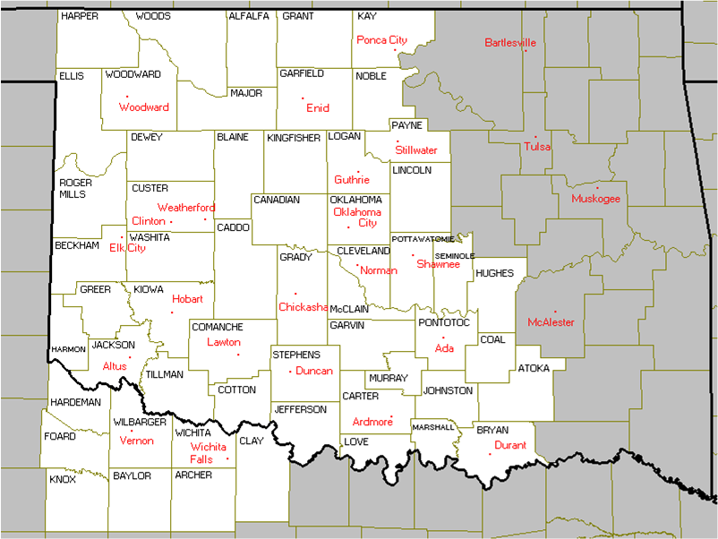
During the afternoon and evening of October 4, 1998, a total of 19 tornadoes struck the portion of Oklahoma counties served by the NWS Norman forecast office. These include tornadoes in the cities of Moore and Shawnee. Seven more tornadoes touched down in northeastern Oklahoma in the area served by the NWS office in Tulsa.
A major severe weather outbreak occurred across western and central Oklahoma from the afternoon of the October 4, 1998 through the early morning of the October 5, 1998. This outbreak produced in 19 tornadoes, straight-line wind damage, and hail as large as baseballs within the NWS Norman county warning area. Significant flooding also occurred across portions of Lincoln and Noble Counties, where numerous costly bridges were destroyed.
Thunderstorms first developed over northwest Oklahoma during the early and mid-afternoon where hail larger than golf balls was reported in Major and Woodward Counties.
As the thunderstorms associated with these tornadoes moved east, additional thunderstorms began to intensify farther south. Near Mountain Park in Kiowa County, Baseball size hail destroyed numerous car windshields.
Major flooding developed across Noble, Lincoln, and Payne Counties shortly after midnight on the October 5, 1998. Red Rock Creek and Black Bear Creek near Red Rock in Payne County, overflowed their banks between U.S. Highway 77 and U.S. Interstate Highway I-35, and washed away several small bridges. Damage was estimated at $200,000.
Six to seven inches of rain fell across a large portion of Lincoln County. At least 3 bridges were washed away by the floods including 1 bridge 1 mile east of Kendrick, and dozens of roads suffered erosion damage. Creeks also overflowed their banks in Stroud, Davenport, and Agra. At least $500,000 in damage resulted. Between 4 and 5 inches of rain fell across Payne County forcing the Cu Chee Creek to overflow its banks, flooding many roads in Cushing and Stillwater.
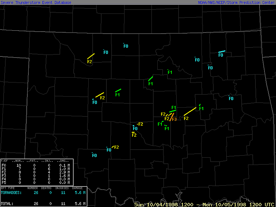
A total of 26 tornadoes were documented, making this the largest tornado outbreak to occur in Oklahoma during the climatological autumn season (SEP-OCT-NOV) and the month of October since records began in 1950.
The following tables and maps include only the tornadoes in the NWS Norman County Warning Area on October 4, 1998.
NOTE: The tornadoes are number with respect to their order of occurrence in only the NWS Norman county warning area.
| Tornadoes by Intensity | |||||||
| F? | F0 | F1 | F2 | F3 | F4 | F5 | Total |
| 0 | 6 | 5 | 7 | 1 | 0 | 0 | 19 |
| Tornado Number |
Storm ID |
Date | Time (CST) |
Length of Path (miles) |
Width of Path (yards) |
F-Scale | Killed | Injured | County | Location |
|---|---|---|---|---|---|---|---|---|---|---|
| 1 | A1 | 10/04/1998 | 1425-1443 | 10 | 440 | F2 | 0 | 0 | Woods/ Alfalfa | 11 SSW Dacoma - 4 NW Carmen |
|
Damage was first reported south of Dacoma where an old abandoned house was damaged and a barn and garage were destroyed. As the tornado moved into western Alfalfa County, an office building at Carmen Field Limited Partnership and a local gas plant were completely destroyed. A modular home adjacent to the gas plant also had most of its roof blown off. Numerous witnesses described this strong tornado as very large and was at least a quarter of a mile wide. |
||||||||||
| 2 | A2 | 10/04/1998 | 1505 | 0.1 | 25 | F0 | 0 | 0 | Alfalfa | 5 SW Cherokee |
|
|
||||||||||
| 3 | A3 | 10/04/1998 | 1604 | 0.1 | 25 | F0 | 0 | 0 | Grant | 5 W Medford |
|
|
||||||||||
| 4 | B1 | 10/04/1998 | 1638-1641 | 1.5 | 25 | F0 | 0 | 0 | Blaine | 8 SW - 6.5 SW Watonga |
|
|
||||||||||
| 5 | B2 | 10/04/1998 | 1650-1712 | 12 | 200 | F2 | 0 | 0 | Blaine | 3 SW - 9 ENE Watonga |
|
|
||||||||||
| 6 | C1 | 10/04/1998 | 1714 | 0.3 | 50 | F0 | 0 | 0 | Comanche | 5 N Medicine Park |
|
|
||||||||||
| 7 | B3 | 10/04/1998 | 1728-1742 | 7 | 100 | F1 | 0 | 0 | Kingfisher | 6 SW - 2 SE Dover |
|
|
||||||||||
| 8 | C2 | 10/04/1998 | 1745 | 0.5 | 25 | F0 | 0 | 0 | Caddo | 1 NE Cyril |
|
|
||||||||||
| 9 | B4 | 10/04/1998 | 1747-1756 | 6 | 100 | F1 | 0 | 0 | Payne/ Noble | 10 W - 6 NW Stillwater |
|
|
||||||||||
| 10 | C3 | 10/04/1998 | 1754-1755 | 1.5 | 200 | F2 | 0 | 0 | Grady | 9 WSW - 7.5 WSW Ninnekah |
|
|
||||||||||
| 11 | C4 | 10/04/1998 | 1915-1921 | 5 | 100 | F2 | 0 | 0 | Grady/ McClain | 4 NW Blanchard - 2 SSW Newcastle |
|
|
||||||||||
| 12 | C5 | 10/04/1998 | 1926-1928 | 1.5 | 33 | F0 | 0 | 0 | McClain/ Cleveland | N Newcastle - SW OKC |
|
|
||||||||||
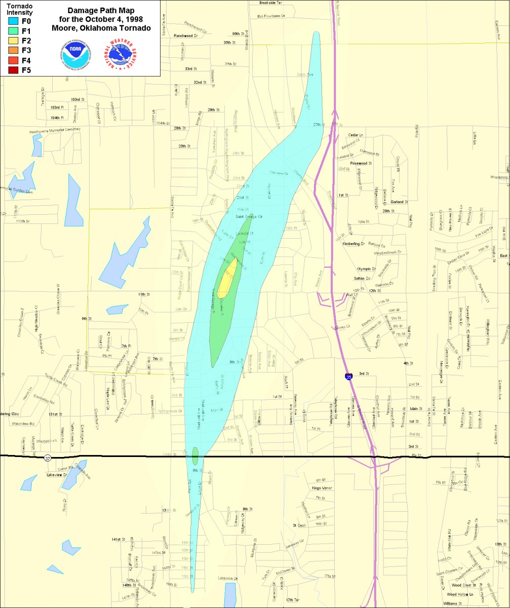
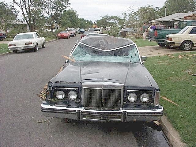
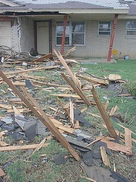
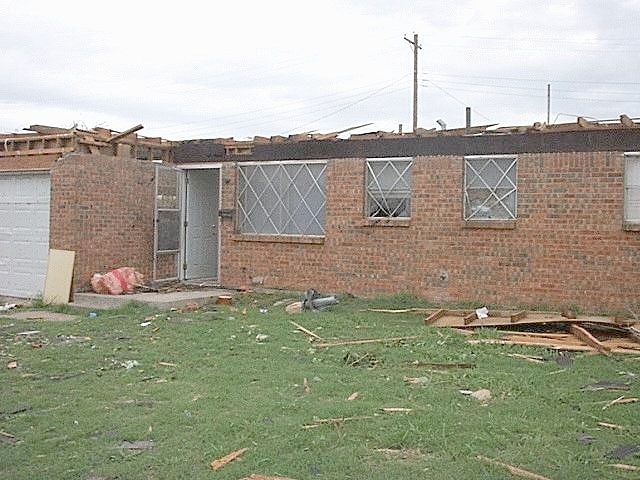
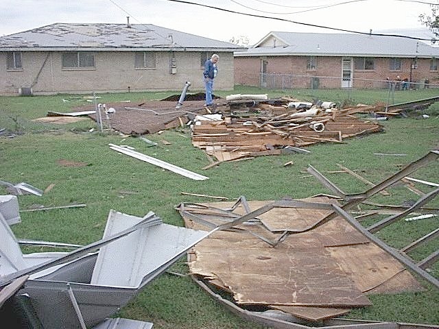
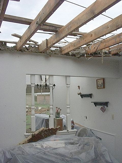
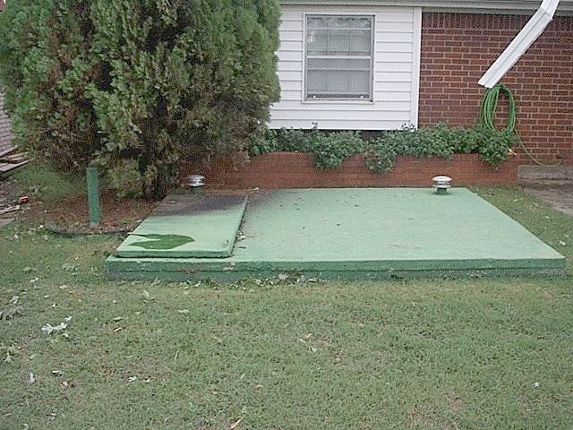
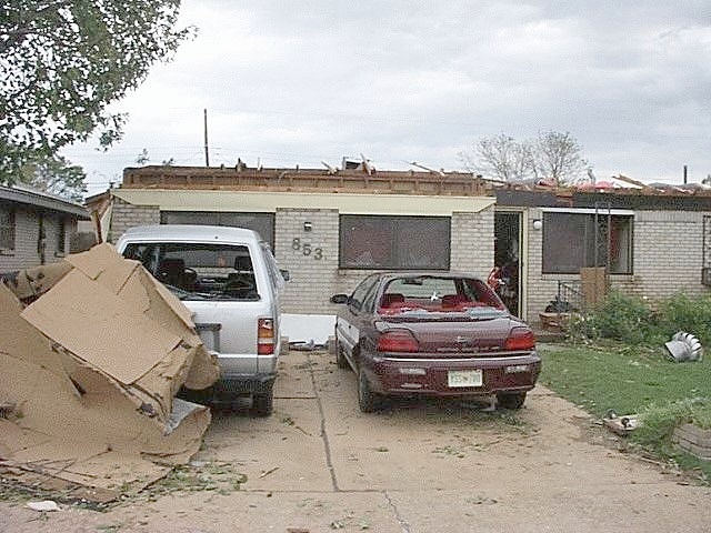
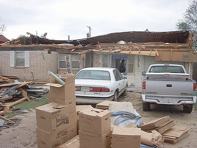
| 13 | C6 | 10/04/1998 | 1934-1941 | 3 | 580 | F2 | 0 | 0 | Cleveland | Moore |
|
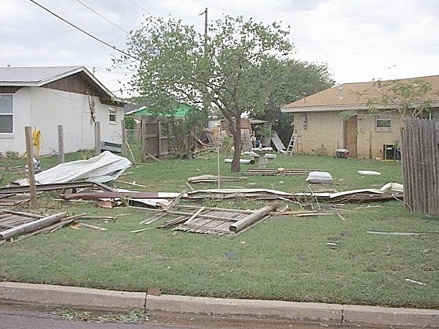
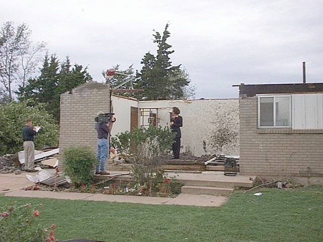
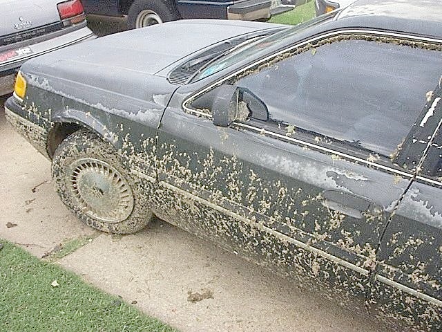
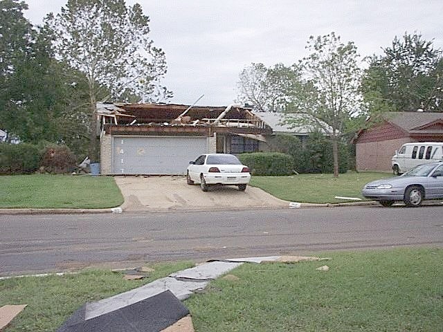
The most intense damage occurred along NW 12th Avenue to the west of Janeway Avenue where F2 damage was observed. In total, 10 single-family residences were either destroyed or severely damaged; 8 multifamily buildings were severely damaged; and hundreds of other homes and businesses sustained minor damage. Damage estimates were near 2 million dollars. More information is available in the Moore Tornado tab. |
||||||||||
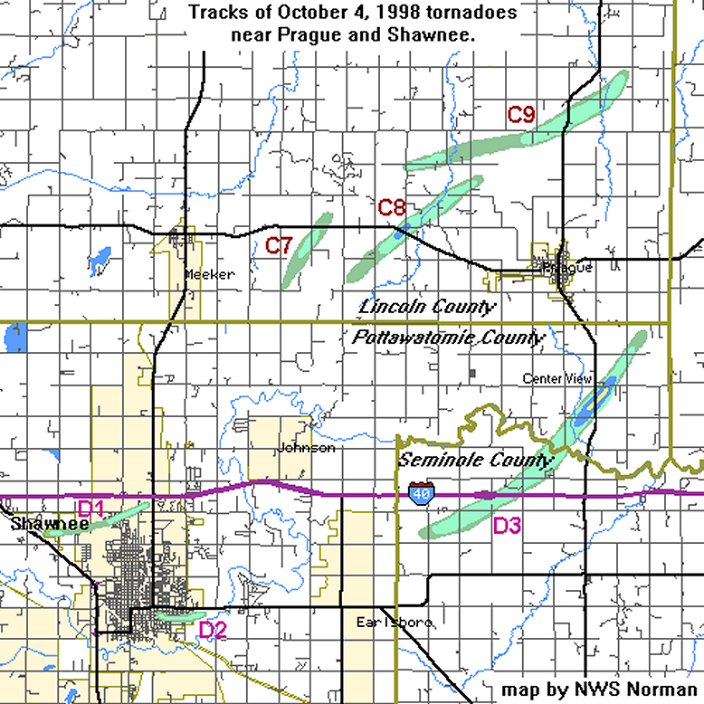
| 14 | C7 | 10/04/1998 | 2037-2040 | 3 | 580 | F2 | 0 | 0 | Lincoln | 4 SE - 5 E Meeker |
|
F2 damage occurred about 1/2 mile south of U.S. Highway 62, where three homes received significant roof damage, and an RV was pushed over onto its side. The tornado crossed U.S. Highway 62 with light damage to trees and minor damage to a house along the highway. The tornado likely dissipated just northeast of the intersection of U.S. Highway 62 and NS 347 Road. |
||||||||||
| 15 | C8 | 10/04/1998 | 2045-2052 | 6 | 580 | F2 | 0 | 0 | Lincoln | 7 W - 4 NW Prague |
|
A mobile home along U.S. Highway 62 just west of NS 350 Road was destroyed. The metal frame that supported the home and most of the contents was deposited northwest of the original location up to 150 yards. Other debris was thrown north-northeast across U.S. Highway 62. The tornado then continued northeast and damage was noted for 3/4 of a mile along NS 350 Road centered on U.S. Highway 62. Slight damage to trees and outbuildings was observed along NS 352 Road approximately 2 miles north of U.S. Highway 62. The tornado probably dissipated northeast of this point, although roads became inaccessible due to flooding and made it difficult to determine the exact location. In addition, a 6-mile-long swath of damaging straight-line winds accompanied this tornado from 6 miles west of Prague to 3 miles northwest of Prague, resulting in massive tree damage. |
||||||||||
| 16 | D1 | 10/04/1998 | 2050-2055 | 3 | 100 | F1 | 0 | 0 | Pottawatomie | NW Shawnee |
|
Extensive tree damage occurred on a private golf course just west of Acme road. Minor damage also occurred to the roof of the clubhouse and to the roof-mounted air conditioning unit. Widespread tree and roof damage also occurred in a subdivision south of 45th St. and west of Kickapoo. In addition to a mobile home being destroyed near the east end of the damage path, which is believed to be the result of a tornado, many other mobile homes nearby received minor damage. More damage occurred 1 mile southeast of Dale in Pottawatomie County where numerous trees and signs were either destroyed or uprooted along Interstate 40, a shed was destroyed, and a barn was unroofed along OK State Highway 102. Oklahoma Mesonet also measured a wind gust of 72 mph at 2055 CST, 3 miles north-northwest of Shawnee. |
||||||||||
| 17 | C9 | 10/04/1998 | 2052-2108 | 8 | 440 | F1 | 0 | 6 | Lincoln | 6 NW - 7 NNE Prague |
|
This tornado, rated an F1, touched down at the intersection of EW 102 Road and NS 350 Road where outbuildings received moderate damage. Less than 1/4 of a mile away on EW 102 Road, a mobile home was lifted and thrown east about 100 yards, uprooting a power pole while airborne. The mobile home was destroyed upon impact. All 6 family members who took shelter inside an interior closet were injured. All injuries were minor, except for the father who suffered broken ribs, a cracked pelvis and head injuries. He stayed overnight in a nearby hospital and was released the next day. As the tornado continued east-northeast along NS 352 Road, south of the community of Wilzetta, an outbuilding was unroofed, minor damage occurred to a house roof, and trees were uprooted. Tree and power line damage continued to about 2 or 3 miles east of Wilzetta. The tornado then turned more to the northeast as it crossed SH 99 where a mobile home received minor damage, 3 outbuildings were destroyed, a few logs at a sawmill were tossed, and trees were downed. Scattered tree damage was observed to just southwest of the intersection of NS 357 Road and EW 99 Road where the tornado lifted. In addition to the tornadoes near Prague, straight-line winds were responsible for downing numerous trees and awnings of several businesses in downtown Prague. |
||||||||||
| 18 | D2 | 10/04/1998 | 2058-2100 | 2 | 100 | F1 | 0 | 0 | Pottawatomie | SE Shawnee |
|
The exact damage resulting from the tornado was difficult to assess, but it is believed it was limited to fallen trees, downed power lines, and minor roof and structural damage to many homes. The area of straight-line wind damage was approximately 2.5 miles wide and 5 miles long, and occurred from the western side of Shawnee to the eastern side of Shawnee. Damage included widespread fallen trees in a suburban area north of Highland extending several blocks either side of Kickapoo, in the Woodland Park area, Boy Scout Park, and in the rural area along and south of Farrel Road between Harrison and Bryan. One tree fell on and heavily damaged the Beard House, a local landmark that was the first homestead built in Shawnee in 1895. An east-facing cinder block wall of a warehouse was blown outward in the vicinity of Minnesota and Pennsylvania Streets, and structural damage occurred to many buildings in downtown Shawnee, including toppled brick walls and broken windows. The combination of widespread straight-line wind damage and a tornado resulted in major damage over a very large area. |
||||||||||
| 19 | D3 | 10/04/1998 | 2108-2125 | 10 | 880 | F3 | 0 | 1 | Seminole/ Pottawatomie | 5 WNW Little - Center View-3 SE Prague |
|
This strong tornado touched down 5 miles west-northwest of Little, near the intersection of EW 114 Road and NS 351 Road in northwestern Pottawatomie County, where minor tree damage was observed. The tornado, rated an F3, then increased in size to approximately a 1/2 mile wide as it moved northeast. As it crossed NS 351 Road and then EW 113 Road, a number of outbuildings were heavily damaged, and trees were snapped. Three mobile homes received light damage near the north edge of the path, and 3 other homes received light damage to shingles. The tornado crossed U.S. Interstate Highway I-40 and blew over a truck which was carrying hazardous materials. The tornado then continued northeast unroofing a mobile home, causing damage to trees and destroying a number of outbuilding before crossing the North Canadian River into northeast Pottawatomie County. Along EW 110 Road, significant tree damage was observed, and a barn was partially unroofed. The community of Center View near the intersection of OK State Highway 99 and EW 109 Road was then hard hit with most of the damage south and east of this intersection. From the debris pattern, the center of the tornado crossed OK State Highway 99 one-half mile south of EW 109 Road. A house along OK State Highway 99 was unroofed and lost most of its exterior walls. Three homes suffered major damage along EW 109 Road. Two other homes suffered significant damage. As the tornado continued moving northeast another home suffered significant roof damage, and the south facing brick wall was buckled. The garage was destroyed. Steel and cinder block from the garage were impaled in a tree. There was also significant damage to large trees. Farther northeast, damage to a roof was noted, and a large number of power lines were downed along NS 357 Road near the intersection of EW 108 Road. One outbuilding was damaged, and light damage was observed in trees just south of EW 107 Road. In total, at least 60 homes or businesses were damaged. |
||||||||||
| Tornado Number |
Storm ID |
Date | Time (CST) |
Length of Path (miles) |
Width of Path (yards) |
F-Scale | Killed | Injured | County | Location |
|---|---|---|---|---|---|---|---|---|---|---|
| 14 | C6 | 10/04/1998 | 1934-1941 | 3 | 580 | F2 | 0 | 0 | Cleveland | Moore |
Surveyor: Greg Stumpf, National Severe Storms Laboratory
The tornado developed about 1/2 mile north of SW 19th Ave, just east of Santa Fe Ave. It tracked almost due north at first, and then curved NNE. The primary damage from this tornado was to vegetation, wood fence paneling, and roof shingles. Although the above map indicates distinct areas of F1 and F2 damage, these damages (structural damage to homes and businesses) occurred mostly in spotty locations. The reason for this was due to either suction vortex action, or the combination of building construction and orientation to the wind. Several homes lost all or parts of their roofs, leaving them uninhabitable. One home lost a portion of an exterior wall. The tornado crossed Shields Ave. and tore some roofing sections off of a few warehouses. The tornado then dissipated just west of I-35.
 |
 |
 |
 |
 |
 |
 |
 |
 |
 |
 |
 |
During the afternoon and evening of October 4, 1998, a total of 19 tornadoes struck the portion of Oklahoma counties served by the NWS Norman forecast office. These include tornadoes in the cities of Moore and Shawnee. Seven more tornadoes touched down in northeastern Oklahoma in the area served by the NWS office in Tulsa.
| Tornadoes by Intensity | |||||||
| F? | F0 | F1 | F2 | F3 | F4 | F5 | Total |
| 0 | 10 | 7 | 8 | 1 | 0 | 0 | 26 |
| Tornado Number |
Storm ID |
Date | Time (CST) |
Length of Path (miles) |
Width of Path (yards) |
F-Scale | Killed | Injured | County | Location |
|---|---|---|---|---|---|---|---|---|---|---|
| 1 | A1 | 10/04/1998 | 1425-1443 | 10 | 440 | F2 | 0 | 0 | Woods/ Alfalfa | 11 SSW Dacoma - 4 NW Carmen |
| 2 | A2 | 10/04/1998 | 1505 | 0.1 | 25 | F0 | 0 | 0 | Alfalfa | 5 SW Cherokee |
| 3 | A3 | 10/04/1998 | 1604 | 0.1 | 25 | F0 | 0 | 0 | Grant | 5 W Medford |
| 4 | B1 | 10/04/1998 | 1638-1641 | 1.5 | 25 | F0 | 0 | 0 | Blaine | 8 SW - 6.5 SW Watonga |
| 5 | B2 | 10/04/1998 | 1650-1712 | 12 | 200 | F2 | 0 | 0 | Blaine | 3 SW - 9 ENE Watonga |
| 6 | C1 | 10/04/1998 | 1714 | 0.3 | 50 | F0 | 0 | 0 | Comanche | 5 N Medicine Park |
| 7 | B3 | 10/04/1998 | 1728-1742 | 7 | 100 | F1 | 0 | 0 | Kingfisher | 6 SW - 2 SE Dover |
| 8 | C2 | 10/04/1998 | 1745 | 0.5 | 25 | F0 | 0 | 0 | Caddo | 1 NE Cyril |
| 9 | B4 | 10/04/1998 | 1747-1756 | 6 | 100 | F1 | 0 | 0 | Payne/ Noble | 10 W - 6 NW Stillwater |
| 10 | C3 | 10/04/1998 | 1754-1755 | 1.5 | 200 | F2 | 0 | 0 | Grady | 9 WSW - 7.5 WSW Ninnekah |
| 11 | B5 | 10/04/1998 | 1838-1839 | 0.4 | 125 | F1 | 0 | 0 | Pawnee | Pawnee |
| 12 | C4 | 10/04/1998 | 1915-1921 | 5 | 100 | F2 | 0 | 0 | Grady/ McClain | 4 NW Blanchard - 2 SSW Newcastle |
| 13 | C5 | 10/04/1998 | 1926-1928 | 1.5 | 33 | F0 | 0 | 0 | McClain/ Cleveland | N Newcastle - SW OKC |
| 14 | C6 | 10/04/1998 | 1934-1941 | 3 | 580 | F2 | 0 | 0 | Cleveland | Moore |
| 15 | B6 | 10/04/1998 | 1956-1957 | 1 | 75 | F0 | 0 | 0 | Osage | 1 SSW - 1 SSE Barnsdall |
| 16 | C7 | 10/04/1998 | 2037-2040 | 3 | 580 | F2 | 0 | 0 | Lincoln | 4 SE - 5 E Meeker |
| 17 | C8 | 10/04/1998 | 2045-2052 | 6 | 580 | F2 | 0 | 0 | Lincoln | 7 W - 4 NW Prague |
| 18 | D1 | 10/04/1998 | 2050-2055 | 3 | 100 | F1 | 0 | 0 | Pottawatomie | NW Shawnee |
| 19 | C9 | 10/04/1998 | 2052-2108 | 8 | 440 | F1 | 0 | 6 | Lincoln | 6 NW - 7 NNE Prague |
| 20 | D2 | 10/04/1998 | 2058-2100 | 2 | 100 | F1 | 0 | 0 | Pottawatomie | SE Shawnee |
| 21 | B7 | 10/04/1998 | 2105-2116 | 8 | 50 | F0 | 0 | 0 | Nowata | 2 NE Watovia - 10 ESE Nowata |
| 22 | D3 | 10/04/1998 | 2108-2125 | 10 | 880 | F3 | 0 | 1 | Seminole/ Pottawatomie | 5 WNW Little - Center View-3 SE Prague |
| 23 | E1 | 10/04/1998 | 2119 | 0.5 | 50 | F0 | 0 | 0 | Tulsa | 3 NW Collinsville |
| 24 | D4 | 10/04/1998 | 2137-2208 | 27 | 1400 | F2 | 0 | 4 | Okfuskee/ Okmulgee | 2 SE Boley - IXL - Haydenville - 3 SW Nuyaka |
| 25 | D5 | 10/04/1998 | 2217-2218 | 1 | 100 | F1 | 0 | 0 | Okmulgee | 2 E - 2 ENE Nuyaka |
| 26 | D6 | 10/04/1998 | 2327 | 0.8 | 50 | F0 | 0 | 0 | Wagoner | 1 SE Tullahassee |
The official NWS Norman storm data report for October 1998 is available here.
The official NWS Tulsa storm data report for October 1998 is available here.
|
The following are severe weather reports received and issued as local storm reports (LSRs) by the NWS Norman staff for the October 4-5, 1998 tornado and severe weather outbreak. These were the preliminary reports received by the NWS. For the final severe weather documentation, refer to the Storm Data links above.
LOCAL STORM REPORTS
NATIONAL WEATHER SERVICE NORMAN OK

SUMMARY REPORT OF LSRS ISSUED BY NWS NORMAN ON OCTOBER 4-5, 1998

TIME (CDT) .....CITY LOCATION.....STATE   ...EVENT/REMARKS...
           ....COUNTY LOCATION....

0220 PM    5 NW ERICK                OK   1.75 INCH HAIL
10/09/01   BECKHAM                        AMATEUR RADIO REPORT

0239 PM    5 WNW SAYRE               OK   TORNADO
10/09/01   BECKHAM                        AMATEUR RADIO REPORT.

0247 PM    5 SE SWEETWATER           OK   TORNADO
10/09/01   BECKHAM                        SHERIFFS OFFICE REPORT.

0245 PM    6 W SAYRE                 OK   1.00 INCH HAIL
10/09/01   BECKHAM                        REPORTED BY PUBLIC

0315 PM    1/2 E BERLIN              OK   TORNADO
10/09/01   ROGER MILLS                    BECKHAM CO EMERGENCY

0323 PM    BERLIN                    OK   WIND DAMAGE. ROOF OFF MOBILE
10/09/01   ROGER MILLS                    HOME. BECKHAM COUNTY EMERGENCY

0400 PM    7 S BUTLER                OK   1.00 INCH HAIL
10/09/01   CUSTER                         WASHITA NWR

0420 PM    HERRING                   OK   1.00 INCH HAIL
10/09/01   ROGER MILLS                    RPTD BY SHERIFFS OFFICE

0425 PM    15 NNW ELK CITY           OK   1.00 INCH HAIL
10/09/01   BECKHAM                        RPTD BY PUBLIC

0445 PM    4 N FOSS                  OK   TORNADO
10/09/01   WASHITA                        RPTD BY MEDIA

0445 PM    4 N FOSS                  OK   TORNADO
10/09/01   CUSTER                         RPTD BY MEDIA

0450 PM    HOBART                    OK   1.00 INCH HAIL
10/09/01   KIOWA                          AMATEUR RADIO REPORT

0508 PM    CORDELL                   OK   TORNADO
10/09/01   WASHITA                        SEVERAL HOMES DAMAGED OR
                                          DESTROYED.  SHERIFFS OFFICE
                                          REPORT.

0505 PM    HOBART                    OK   1.50 INCH HAIL
10/09/01   KIOWA                          AMATEUR RADIO REPORT.

0525 PM    HOBART                    OK   1.00 INCH HAIL
10/09/01   KIOWA                          AMATEUR RADIO REPORT.


0528 PM    GOTEBO                    OK   1.00 INCH HAIL
10/09/01   KIOWA                          AMATEUR RADIO REPORT


0530 PM    1 SW CUSTER CITY          OK   1.75 INCH HAIL
10/09/01   CUSTER                         PUBLIC REPORT

0539 PM    1 NE GOTEBO               OK   TORNADO
10/09/01   KIOWA                          AMATEUR RADIO REPORT.


0542 PM    2 WSW MOUNTAIN VIEW       OK   TORNADO
10/09/01   KIOWA                          AMATEUR RADIO REPORT.

0555 PM    9 S COWDEN                OK   TORNADO
10/09/01   WASHITA                        AMATEUR RADIO REPORT.


0557 PM    3 SE WEATHERFORD          OK   TORNADO
10/09/01   CUSTER                         MEDIA REPORT.

0700 PM    3 S ALBERT                OK   TORNADO
10/09/01   CADDO                          RPTD BY SPOTTER

0720 PM    41/2 N GRACEMONT          OK   TORNADO
10/09/01   CADDO                          BINGER P.D. REPORT

0734 PM    COGAR                     OK   1.00 INCH HAIL
10/09/01   CADDO                          AMATEUR RADIO REPORT

0740 PM    2 S MINCO                 OK   .88 INCH HAIL
10/09/01   GRADY                          AMATEUR RADIO REPORT.

0750 PM    2 W COGAR                 OK   2.00 INCH HAIL
10/09/01   CADDO

0805 PM    UNION CITY                OK   1.00 INCH HAIL
10/09/01   CANADIAN                       MUSTANG P.D. REPORT.

0815 PM    2 W MINCO                 OK   1.00 INCH HAIL
10/09/01   GRADY                          AMATEUR RADIO REPORT.

0823 PM    1 W MINCO                 OK   1.75 INCH HAIL
10/09/01   GRADY                          AMATEUR RADIO REPORT.

0848 PM    S. OKLAHOMA CITY          OK   1.00 INCH HAIL
10/09/01   CLEVELAND                      PUBLIC REPORT AT 134TH AND

0910 PM    NEWCASTLE                 OK   .88 INCH HAIL
10/09/01   MCCLAIN                        AMATEUR RADIO REPORT.

0829 PM    NEWCASTLE                 OK   .75 INCH HAIL
10/09/01   MCCLAIN                        AMATEUR RADIO REPORT

0856 PM    MOORE                     OK   .75 INCH HAIL
10/09/01   CLEVELAND                      SOONER ROAD AND SE 134TH.

0925 PM    S. OKLAHOMA CITY          OK   .88 INCH HAIL
10/09/01   CLEVELAND                      SW 134TH AND SANTA FE.

0945 PM    TINKER AFB                OK   1.00 INCH HAIL
10/09/01   OKLAHOMA                       AMATEUR RADIO REPORT.

1025 PM    CHOCTAW                   OK   1.00 INCH HAIL
10/09/01   OKLAHOMA                       MEDIA REPORT.

1050 PM    4 N MIDWAY                OK   .75 INCH HAIL
10/09/01   LINCOLN                        AMATEUR RADIO REPORT.

1100 PM    HARRAH                    OK   .88 INCH HAIL
10/09/01   OKLAHOMA                       REPORTED BY PD
|
The following table includes radar reflectivity and storm relative velocity imagery at selected times during the October 4, 1998 tornado outbreak, The radar imagery comes from from the Twin Lakes, OK Radar (KTLX).
| 0.5° Reflectivity | 0.5° Storm Relative Velocity or Base Velocity |
| 3:26 PM CDT: Onset of the Carmen tornado | |
 |
 |
| 5:54 PM CDT: During the Watonga tornado | |
 |
 |
| 6:14 PM CDT: During the Lake Lawtonka tornado | |
 |
 |
| 6:29 PM CDT: The beginning of the Dover tornado | |
 |
 |
| 6:47 PM CDT: The Dover tornado had just dissipated, the Lake Carl Blackwell tornado was just beginning west of Stillwater, and the brief Cyril tornado had occurred just 2 minutes before. | |
 |
 |
| 6:57 PM CDT: A tornado had just occurred WSW of Ninnekah (SW of Chickasha) | |
 |
 |
| 8:17 PM CDT: During the tornado north of Blanchard | |
 |
 |
| 8:31 PM CDT: Just after the tornado north of Newcastle, and just before the Moore tornado | |
 |
 |
| 8:36 PM CDT: A tornado is producing damage in the city of Moore. | |
 |
 |
| 9:11 PM CDT: Very strong winds occurring between McLoud and Shawnee | |
 |
 |
| 9:36 PM CDT: Just before a tornado touches down southeast of Meeker | |
 |
 |
| 9:46 PM CDT: A tornado is occurring west of Prague | |
 |
 |
| 9:50 PM CDT: The same tornado is now northwest of Prague, and another has just begun on the northwest side of Shawnee | |
 |
 |
| 9:55 PM CDT: The tornado in Shawnee is dissipating while another tornado has formed northwest of Prague | |
 |
 |
| 10:00 PM CDT: A second tornado is occurring now on the southeast side of Shawnee, while the tornado northwest of Prague continues. | |
 |
 |
| 10:05 PM CDT: The tornado north of Prague continues | |
 |
 |
| 10:10 PM CDT: The tornado has dissipated to the north-northeast of Prague, but the strongest tornado of the evening has just formed west-northwest of Little | |
 |
|
| 10:15 PM CDT: The tornado is about to move northeast into Pottawatomie County. | |
 |
 |
| 10:20 PM CST: The community of Center View is being struck with a strong tornado. | |
 |
 |
Thanks to Greg Stumpf, Daphne LaDue and Peter Laws of the National Severe Storms Laboratory, Jim LaDue, Mark Fresch, Bob Lee and John Ferree of the Operational Support Facility, David Dowell of the University of Oklahoma, Roger Edwards of the Storm Prediction Center, John Finch of NWS/Wichita, Gary England and Val Castor who all provided information about these storms and helped with surveys. Mike Branick, Chris Buonanno and Doug Speheger conducted surveys for NWS/Norman. Many thanks to all of the Emergency Management agencies who gave reports on the night of the October 4, 1998 and also helped with the storm surveys, Oklahoma Highway Patrol, and other local agencies in the communities that were affected.

