|
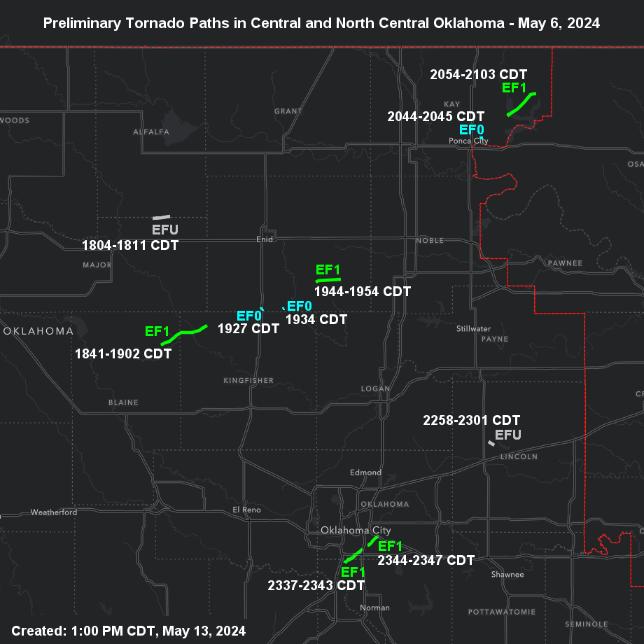
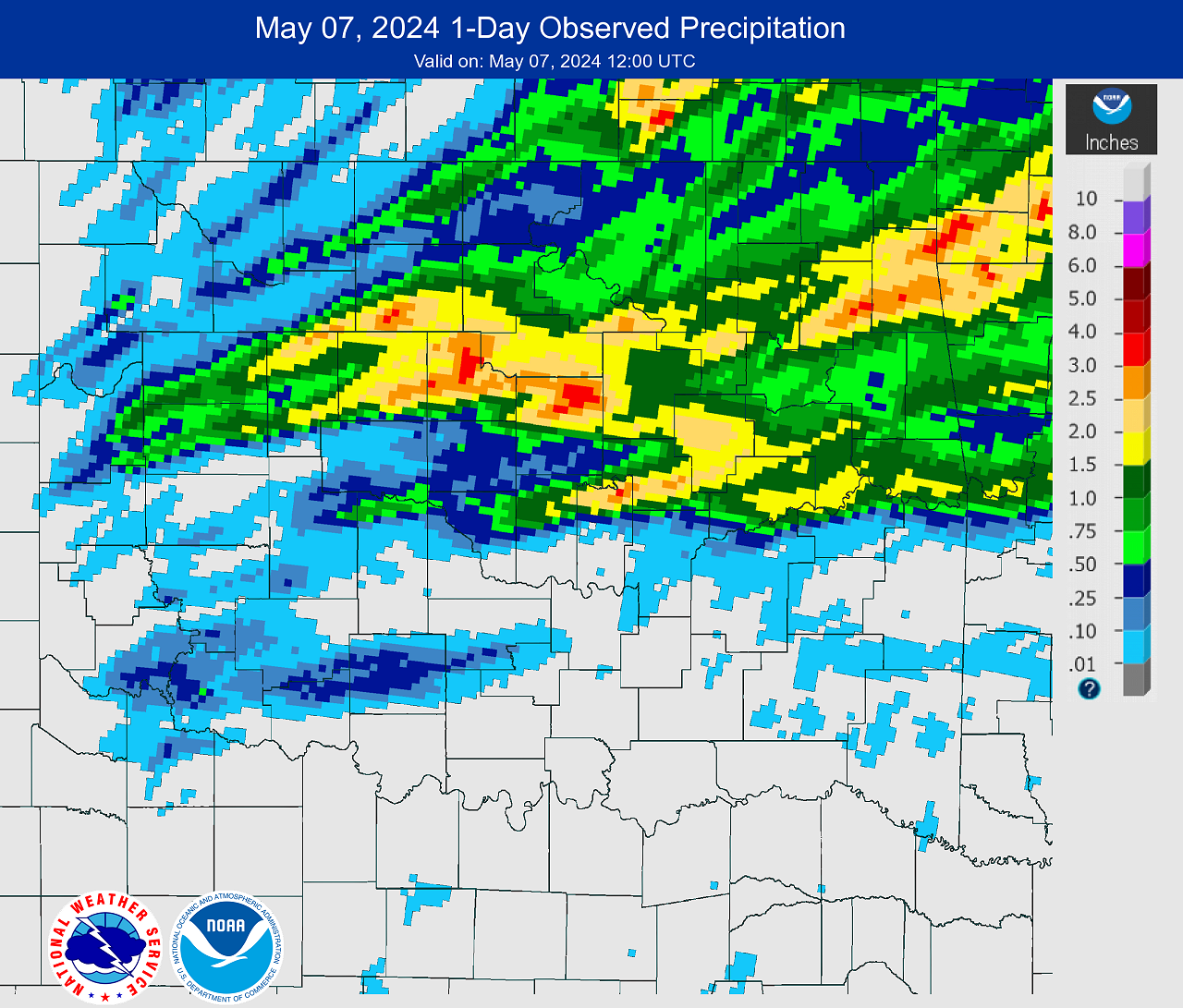
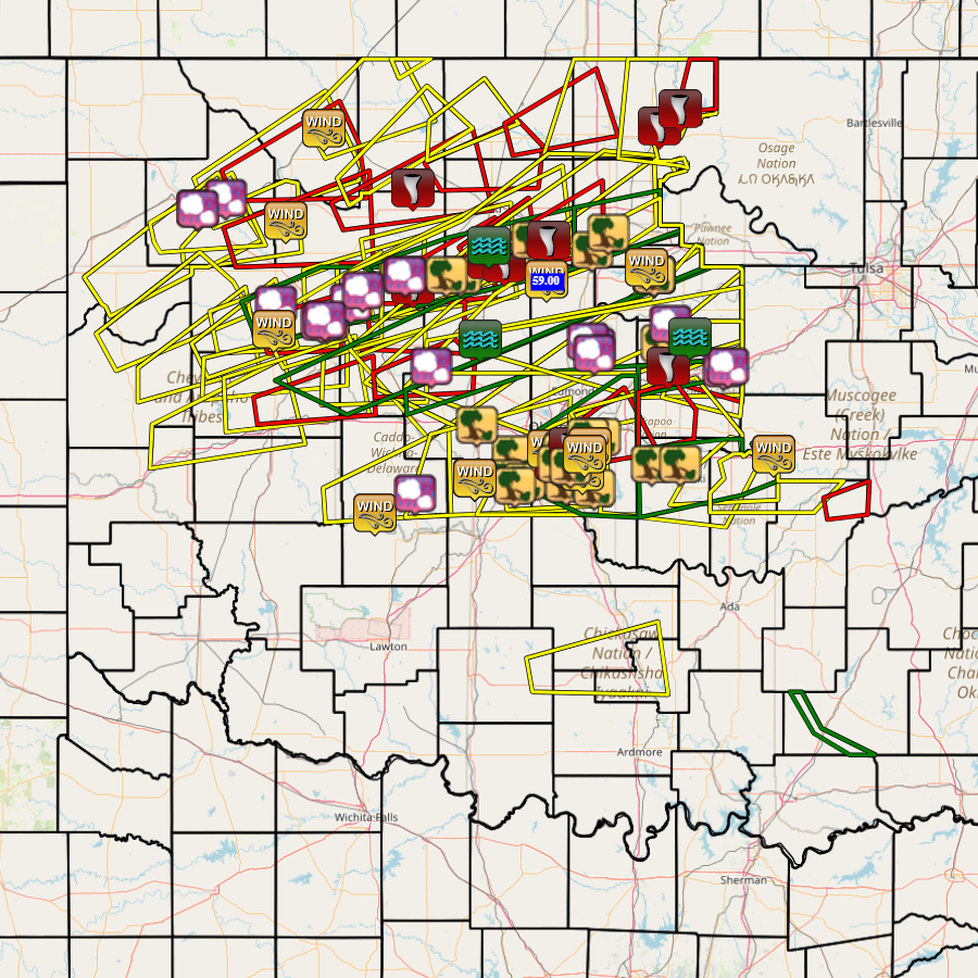
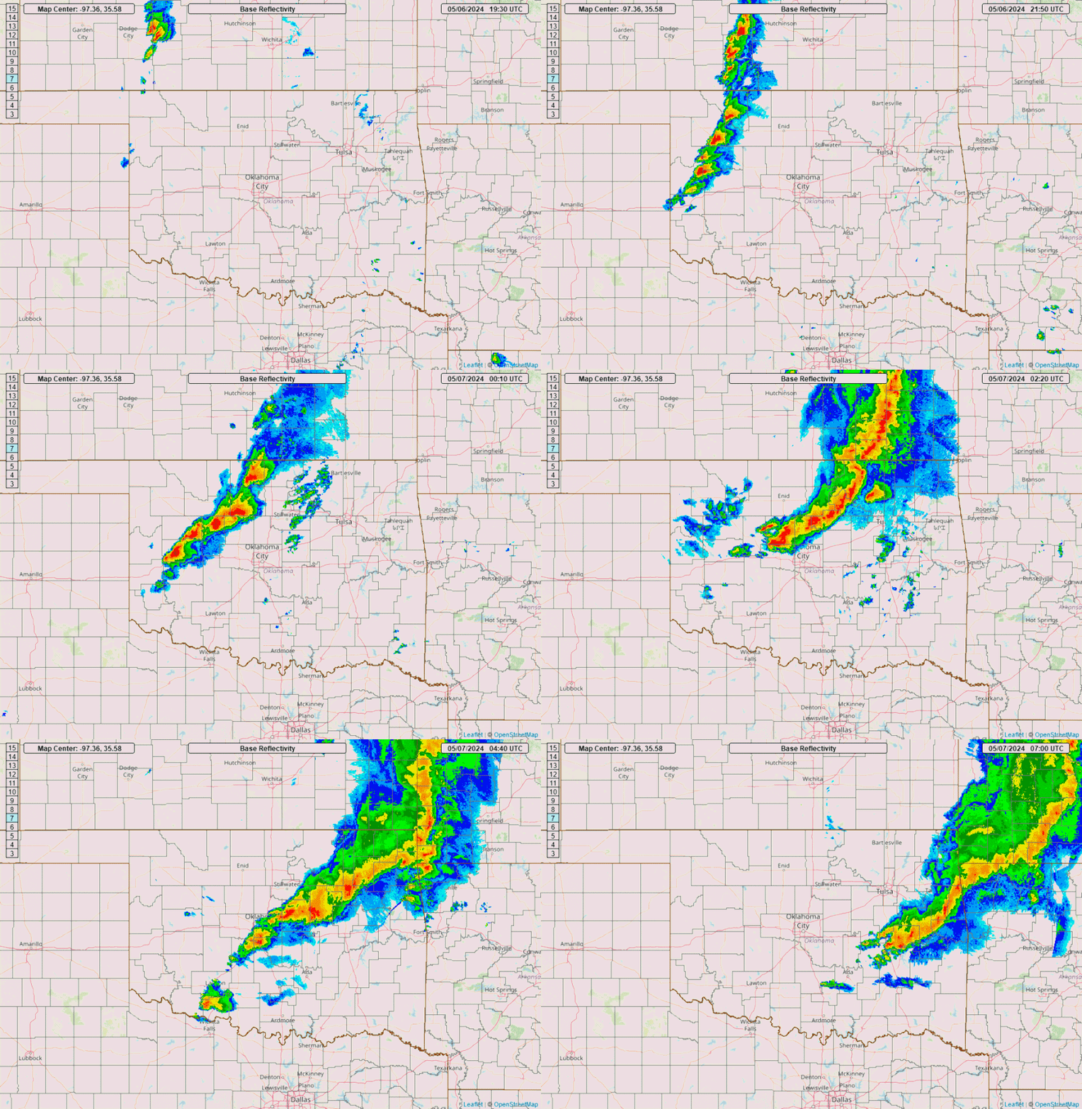
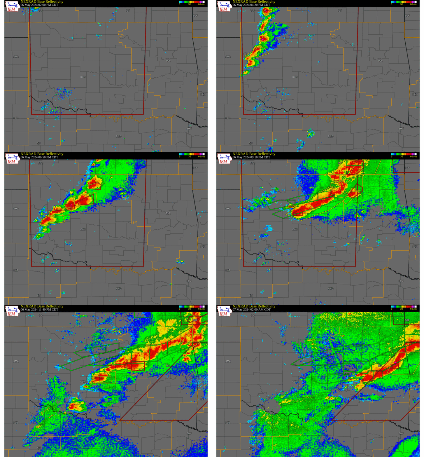
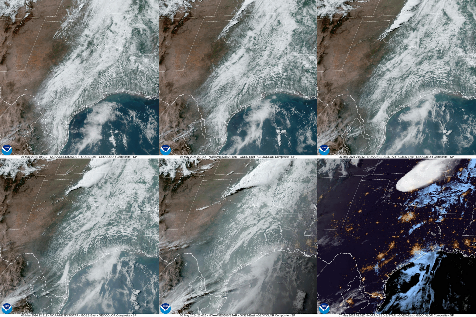
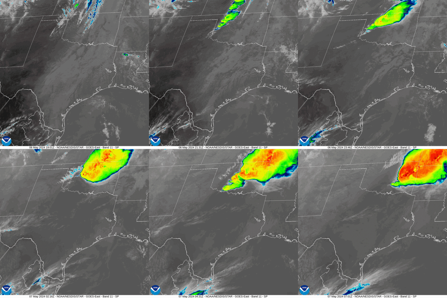
During the mid afternoon of May 6, 2024, thunderstorms initiated along a dryline in northwestern and west central Oklahoma and quickly became severe. Initially, several supercell thunderstorms developed within the line of thunderstorms and produced large hail (1.00-2.75 inches in diameter) and damaging winds (59-89 mph gusts). As the thunderstorm line progressed to the east by early evening, supercell thunderstorms began dropping weak tornadoes in parts of north central and central Oklahoma. Eventually, thunderstorms began training across parts of central Oklahoma and produced precipitation amounts 2-4 inches in a short period of time (~1-2 hours). The heavy runoff from these storms created flash flooding in Kingfisher, Logan, Lincoln, Payne and southern Garfield counties. As the thunderstorm line continued to the east in the NWS Norman forecast area, reports of more tornadoes, large hail, severe wind gusts, and wind damage were received. By the late evening of May 6th, other storms formed in southwestern Oklahoma and moved to the east, but these storms were weaker than the previous storms to the north. The severe weather had moved out of the NWS Norman forecast area by the early morning of May 7, 2024. A total of 15 tornadoes have been documented in Oklahoma by the NWS Norman and NWS Tulsa forecast offices for the May 6-7, 2024 severe weather and tornado event. Of this total, 10 tornadoes occurred in the NWS Norman forecast area and 5 tornadoes occurred within the NWS Tulsa forecast area. Almost all of the tornadoes were unrated or weak with the exception of the deadly EF-4 tornado that hit the Barnsdall and Bartlesville communities as well as other areas in Osage and Washington counties, and an EF-2 tornado that traveled through Adair County into Arkansas. Both of these tornadoes occurred within the NWS Tulsa forecast area. |
|
| Year | Total |
| 2015 | 16 |
| 2024 | 15 |
| 1994 | 11 |
| 1998 | 6 |
| 1965 | 5 |
| 1961 | 3 |
NOUS44 KOUN 100226
PNSOUN
OKZ004>048-050>052-TXZ083>090-101430-

Public Information Statement
National Weather Service Norman OK
926 PM CDT Thu May 9 2024

...NWS Damage Survey for 05/06/24 Tornado Event - Update # 1...

.Update...Added seven tornadoes, adjusted path of the two
previous tornadoes (South of Helena and Okeene-Lacey).

.Overview...Investigation continues not only with these tornadoes,
and other areas of damage, including areas near Choctaw and
Carney as well as other locations.

.South of Helena...

Rating:                 EF-Unknown
Estimated Peak Wind:    N/A
Path Length /statute/:  4 miles
Path Width /maximum/:   To be determined
Fatalities:             0
Injuries:               0

Start Date:             05/06/2024
Start Time:             06:04 PM CDT
Start Location:         6 SSW Helena / Major County / OK
Start Lat/Lon:          36.46 / -98.32

End Date:               05/06/2024
End Time:               06:11 PM CDT
End Location:           5 S Helena / Alfalfa County / OK
End Lat/Lon:            36.47 / -98.25

Survey Summary:
Estimated path. Spotter report of a tornado approximately 5 miles
south of Helena.

.Okeene - Lacey...

Rating:                 EF1
Estimated Peak Wind:    105 to 110 mph
Path Length /statute/:  11 miles
Path Width /maximum/:   300 yards
Fatalities:             0
Injuries:               0

Start Date:             05/06/2024
Start Time:             06:41 PM CDT
Start Location:         4 SSE Okeene / Blaine County / OK
Start Lat/Lon:          36.06 / -98.28

End Date:               05/06/2024
End Time:               07:02 PM CDT
End Location:           1 WNW Lacey / Kingfisher County / OK
End Lat/Lon:            36.12 / -98.10

Survey Summary:
NWS Survey crew found evidence of an EF1 tornado southeast of
Okeene. The tornado began approximately 4 miles southeast of
Okeene and continued to the east-northeast for approximately
10 miles. Another brief, EF0 tornado occurred simultaneously to
the 3 miles to the north of the EF1 tornado.

.South of Bison...

Rating:                 EF0
Estimated Peak Wind:    80 to 85 mph
Path Length /statute/:  0.2 miles
Path Width /maximum/:   50 yards
Fatalities:             0
Injuries:               0

Start Date:             05/06/2024
Start Time:             07:27 PM CDT
Start Location:         1 S Bison / Garfield County / OK
Start Lat/Lon:          36.17 / -97.89

End Date:               05/06/2024
End Time:               07:27 PM CDT
End Location:           1 S Bison / Garfield County / OK
End Lat/Lon:            36.17 / -97.89

Survey Summary:
A storm chaser observed a brief tornado south of Bison. Sign
posts along US Highway 81 were damaged.

.Southeast of Bison...

Rating:                 EF0
Estimated Peak Wind:    80 to 85 mph
Path Length /statute/:  0.2 miles
Path Width /maximum/:   To be determined
Fatalities:             0
Injuries:               0

Start Date:             05/06/2024
Start Time:             07:34 PM CDT
Start Location:         5 ESE Bison / Garfield County / OK
Start Lat/Lon:          36.17 / -97.80

End Date:               05/06/2024
End Time:               07:34 PM CDT
End Location:           5 ESE Bison / Garfield County / OK
End Lat/Lon:            36.17 / -97.80

Survey Summary:
A tornado damaged an outbuilding along Marshall Road. Investigation
continues with this tornado and it may have moved farther northeast.

.Douglas - Covington...

Rating:                 EF1
Estimated Peak Wind:    105 to 110 mph
Path Length /statute/:  6 miles
Path Width /maximum/:   300 yards
Fatalities:             0
Injuries:               0

Start Date:             05/06/2024
Start Time:             07:44 PM CDT
Start Location:         1 W Douglas / Garfield County / OK
Start Lat/Lon:          36.26 / -97.68

End Date:               05/06/2024
End Time:               07:54 PM CDT
End Location:           3 S Covington / Garfield County / OK
End Lat/Lon:            36.27 / -97.58

Survey Summary:
NWS Survey Crew found evidence of an EF1 tornado that began near
Douglas and moved east. Damage was sporadic along the track,
which ended just east of Highway 74 about 5 miles south of
Covington.

.Lake Ponca...

Rating:                 EF0
Estimated Peak Wind:    80 to 85 mph
Path Length /statute/:  0.6 miles
Path Width /maximum/:   30 yards
Fatalities:             0
Injuries:               0

Start Date:             05/06/2024
Start Time:             08:44 PM CDT
Start Location:         3 ENE Ponca City / Kay County / OK
Start Lat/Lon:          36.71 / -97.03

End Date:               05/06/2024
End Time:               08:45 PM CDT
End Location:           3 E Ponca City / Kay County / OK
End Lat/Lon:            36.71 / -97.02

Survey Summary:
This tornado caused tree and house damage on the southwest side
of Lake Ponca.

.Kaw Lake...

Rating:                 EF1
Estimated Peak Wind:    95 to 100 mph
Path Length /statute/:  8 miles
Path Width /maximum/:   75 yards
Fatalities:             0
Injuries:               0

Start Date:             05/06/2024
Start Time:             08:54 PM CDT
Start Location:         4 WNW Kaw City / Kay County / OK
Start Lat/Lon:          36.78 / -96.93

End Date:               05/06/2024
End Time:               09:03 PM CDT
End Location:           6 NNE c / Kay County / OK
End Lat/Lon:            36.86 / -96.82

Survey Summary:
A tornado developed west of Kaw Lake and moved over the Coon
Creek Cove area of Kaw Lake producing tree damage, damage to a
boat dock, and overturned a camper. The tornado moved northeast
over the lake and likely dissipated in northeastern Kay County.

.Northwest of Chandler...

Rating:                 EF-Unknown
Estimated Peak Wind:    N/A
Path Length /statute/:  1.5 miles
Path Width /maximum/:   To be determined
Fatalities:             0
Injuries:               0

Start Date:             05/06/2024
Start Time:             10:58 PM CDT
Start Location:         4 SSE Carney / Lincoln County / OK
Start Lat/Lon:          35.75 / -97.00

End Date:               05/06/2024
End Time:               11:01 PM CDT
End Location:           4 NNE Warwick / Lincoln County / OK
End Lat/Lon:            35.74 / -96.98

Survey Summary:
A Tornado Debris Signature was observed on radar. This tornado is
still being investigated and the path is estimated.

.Southern OKC Metro...

Rating:                 EF1
Estimated Peak Wind:    105 to 110 mph
Path Length /statute/:  5 miles
Path Width /maximum/:   75 yards
Fatalities:             0
Injuries:               0

Start Date:             05/06/2024
Start Time:             11:37 PM CDT
Start Location:         4 WNW Moore / Cleveland County / OK
Start Lat/Lon:          35.37 / -97.56

End Date:               05/06/2024
End Time:               11:43 PM CDT
End Location:           1 NW Valley Brook / Oklahoma County / OK
End Lat/Lon:            35.41 / -97.49

Survey Summary:
This tornado began near SW 104th street and South May Avenue,
just east of the Will Rogers World Airport. A narrow, 75 yard
path was found by an NWS survey crew which produced mainly
EF0 and sporadic EF1 damage as it moved north and east.
Additional EF1 damage was noted along Interstate 240, between
South Walker and South Santa Fe Avenue. The narrow tornado
continued to move northeast, before losing a narrow, convergent
track near SE 59th Street and I-35.

.South OKC and Mid-Del...

Rating:                 EF1
Estimated Peak Wind:    105 to 100 mph
Path Length /statute/:  3.2 miles
Path Width /maximum/:   40 yards
Fatalities:             0
Injuries:               0

Start Date:             05/06/2024
Start Time:             11:44 PM CDT
Start Location:         1 NNE Valley Brook / Oklahoma County / OK
Start Lat/Lon:          35.42 / -97.47

End Date:               05/06/2024
End Time:               11:47 PM CDT
End Location:           Del City / Oklahoma County / OK
End Lat/Lon:            35.45 / -97.43

Survey Summary:
A storage facility was damaged along SE 44th Street east of
Eastern Avenue. The tornado then moved northeast to an area west
of SE 38th Street and Bryant Avenue causing roof damage to a few
homes. Sporadic damage continued to around 15th Street and the
Tinker Diagonal.

&&

EF Scale: The Enhanced Fujita Scale classifies tornadoes into the
following categories:

EF0.....65 to 85 mph
EF1.....86 to 110 mph
EF2.....111 to 135 mph
EF3.....136 to 165 mph
EF4.....166 to 200 mph
EF5.....>200 mph

NOTE:
The information in this statement is preliminary and subject to
change pending final review of the events and publication in
NWS Storm Data.


$$

..speg.
|
As of May 22, 2024, a total of 15 tornadoes have been documented in Oklahoma for The May 6-7, 2024 severe weather and tornado event. Of this total 10 tornadoes occurred in the NWS Norman forecast area and 5 tornadoes occurred within the NWS Tulsa forecast area. Almost all of the tornadoes were unrated or weak with the exception of the deadly EF-4 tornado that hit the Barnsdall and Bartlesville communities as well as other areas in Osage and Washington counties, and an EF-2 tornado that traveled through Adair County into Arkansas. Both of these tornadoes occurred within the NWS Tulsa forecast area.
Tornadoes by Intensity |
|||||||
|---|---|---|---|---|---|---|---|
| EFU | EF0 | EF1 | EF2 | EF3 | EF4 | EF5 | Total |
| 2 | 4 | 7 | 1 | 0 | 1 | 0 | 15 |
| Tornado Number |
Date | Time (CST) |
Length of Path (miles) |
Width of Path (yards) |
F-Scale | Killed | Injured | County | Location |
|---|---|---|---|---|---|---|---|---|---|
| 1 | 05/06/2024 | 1704-1711 | 4 | EF? | 0 | 0 | Major/ Alfalfa | 6.5 SSW - 5.5 S Helena | |
| 2 | 05/06/2024 | 1741-1802 | 11 | 300 | EF1 | 0 | 0 | Blaine/ Kingfisher | 4 SSE Okeene - 1 WNW Lacey |
| 3 | 05/06/2024 | 1827-1827 | 0.2 | 50 | EF0 | 0 | 0 | Garfield | 1 S Bison |
| 4 | 05/06/2024 | 1834-1834 | 0.2 | EF0 | 0 | 0 | Garfield | 5 ESE Bison | |
| 5 | 05/06/2024 | 1844-1854 | 6 | 300 | EF1 | 0 | 0 | Garfield | near Douglas - 3 S Covington |
| 6 | 05/06/2024 | 1944-1945 | 0.6 | 30 | EF0 | 0 | 0 | Kay | just SW of Lake Ponca (3 ENE - 3 E Ponca City) |
| 7 | 05/06/2024 | 1954-2003 | 8 | 75 | EF1 | 0 | 0 | Kay | 4 WNW Kaw City - Kaw Lake (Coon Creek Cove area) - 6 NNE Kaw Lake Dam |
| 8 | 05/06/2024 | 2012-2107 | 40.8 | 1700 | EF4 | 2 | 33 | Osage/ Washington | 4 NE Osage - 2 ESE Dewey |
| 9 | 05/06/2024 | 2158-2201 | 1.5 | EF? | 0 | 0 | Lincoln | 4 SSE Carney - 4 NNE Warwick | |
| 10 | 05/06/2024 | 2200-2204 | 3.2 | 1100 | EF0 | 0 | 0 | Ottawa/ Cherokee KS | 5 SSW Melrose - into KS |
| 11 | 05/06/2024 | 2237-2243 | 5 | 75 | EF1 | 0 | 0 | Cleveland/ Oklahoma | 4 WNW Moore - 1 NW Valley Brook (near SW 104th/May - near I-35/SE 59th) |
| 12 | 05/06/2024 | 2244-2247 | 3 | 40 | EF1 | 0 | 0 | Oklahoma | 1 NNE Valley Brook - Del City (near SE 44th St and Eastern - SE 15th Street/Tinker Diagonal) |
| 13 | 05/06/2024 | 2306-2313 | 4 | 350 | EF1 | 0 | 0 | Creek/ Okmulgee | 6.2 SE Slick - 4.6 WSW Beggs |
| 14 | 05/07/2024 | 0005-0011 | 2.8 | 200 | EF1 | 0 | 0 | Okfuskee | 2.5 N - 3.6 NE Weleetka |
| 15 | 05/07/2024 | 0123-0139 | 11.7 | 800 | EF2 | 0 | 0 | Adair/ Washington AR | 5 SSE Stilwell - 1 E Odell AR |
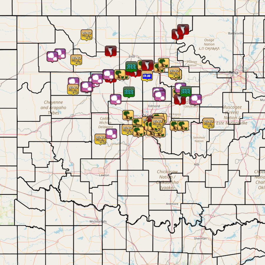
| 05/06/2024 | 9:38 | 3 WNW Moore | Cleveland | OK | Tstm Wnd Dmg | Public | 35.35 | -97.54 | SW 119th between S. Western and S. Penn. Damaged power poles. Facebook report with picture. Time est. from radar. | |
| 05/06/2024 | 10:28 | 2 W Mustang | Canadian | OK | Tstm Wnd Dmg | Public | 35.39 | -97.77 | Trees down, shingles torn from roof, fence panels blown down. | |
| 05/06/2024 | 10:38 | 4 WSW Valley Brook | Oklahoma | OK | Tstm Wnd Dmg | Public | 35.38 | -97.55 | Fence damage. Facebook report with picture. Time estimated from radar. | |
| 05/06/2024 | 10:42 | 2 SE Valley Brook | Oklahoma | OK | Tstm Wnd Gust | 73 mph | Trained Spotter | 35.38 | -97.46 | Corrects previous tstm wnd gst report from 2 SE Valley Brook. Corrects previous tstm wnd gst report from 2 SE Valley Brook. Time estimated from radar. Report from 89th and Bryant. |
| 05/06/2024 | 10:42 | 2 SE Valley Brook | Oklahoma | OK | Tstm Wnd Gust | 78 mph | Trained Spotter | 35.38 | -97.46 | Corrects previous tstm wnd gst report from 2 SE Valley Brook. Time estimated from radar. Report from 89th and Bryant. |
| 05/06/2024 | 10:42 | 2 SE Valley Brook | Oklahoma | OK | Tstm Wnd Gust | 89 mph | Trained Spotter | 35.38 | -97.46 | Time estimated from radar. Report from 89th and Bryant. |
| 05/06/2024 | 15:10 | 4 SE Woodward | Woodward | OK | Hail | 1.75 in. | Trained Spotter | 36.39 | -99.35 | Corrects previous hail report from 4 SE Woodward. Time estimated based on radar. |
| 05/06/2024 | 15:18 | Mooreland | Woodward | OK | Hail | 1.50 in. | Public | 36.43 | -99.21 | Report from mPING. |
| 05/06/2024 | 15:20 | 4 SE Woodward | Woodward | OK | Hail | 1.75 in. | Trained Spotter | 36.39 | -99.35 | |
| 05/06/2024 | 16:09 | 9 N Chester | Major | OK | Tstm Wnd Gust | 82 mph | Trained Spotter | 36.34 | -98.91 | |
| 05/06/2024 | 16:15 | 7 SSW Alva | Woods | OK | Tstm Wnd Gust | 61 mph | Mesonet | 36.71 | -98.72 | |
| 05/06/2024 | 16:33 | 3 S Taloga | Dewey | OK | Hail | 1.75 in. | Trained Spotter | 36.00 | -98.96 | time estimated based on radar. |
| 05/06/2024 | 16:55 | Oakwood | Dewey | OK | Hail | 1.75 in. | Emergency Mngr | 35.93 | -98.70 | |
| 05/06/2024 | 17:09 | 5 S Helena | Alfalfa | OK | Tornado | Trained Spotter | 36.47 | -98.27 | report relayed by NWS employee. | |
| 05/06/2024 | 17:10 | 3 S Canton | Blaine | OK | Hail | 2.75 in. | Trained Spotter | 36.01 | -98.58 | Twitter photo with noted melting; time estimated based on radar. |
| 05/06/2024 | 17:15 | 3 N Putnam | Dewey | OK | Tstm Wnd Gust | 65 mph | Mesonet | 35.90 | -98.97 | |
| 05/06/2024 | 17:35 | Okeene | Blaine | OK | Hail | 1.25 in. | Emergency Mngr | 36.12 | -98.32 | photo relayed through NWSchat. |
| 05/06/2024 | 17:37 | 1 W Oakwood | Dewey | OK | Hail | 1.25 in. | Public | 35.93 | -98.73 | Report from mPING. |
| 05/06/2024 | 17:43 | 4 SE Okeene | Blaine | OK | Tornado | Broadcast Media | 36.08 | -98.27 | ||
| 05/06/2024 | 17:45 | Okeene | Blaine | OK | Hail | 1.75 in. | Fire Dept/Rescue | 36.12 | -98.31 | |
| 05/06/2024 | 17:55 | 3 E Lacey | Kingfisher | OK | Tstm Wnd Dmg | Emergency Mngr | 36.12 | -98.03 | Power poles down and tree damage at Hwy 51 and South Hwy 132. | |
| 05/06/2024 | 17:57 | 2 W Southard | Blaine | OK | Hail | 1.50 in. | Public | 36.06 | -98.52 | Report from mPING. |
| 05/06/2024 | 17:59 | 1 W Lacey | Kingfisher | OK | Tstm Wnd Dmg | Trained Spotter | 36.12 | -98.10 | Spotternetwork Report. Trees Uprooted, power lines snapped, single home structure damage. Time is radar estimate. Possible Tornado Damage. | |
| 05/06/2024 | 18:15 | 1 N Oakwood | Dewey | OK | Hail | 1.25 in. | Public | 35.94 | -98.71 | Report from mPING. |
| 05/06/2024 | 18:27 | 1 S Bison | Garfield | OK | Tornado | Trained Spotter | 36.18 | -97.89 | Initial Spotternetwork report of a rope tornado, also confirmed by broadcast media. | |
| 05/06/2024 | 18:27 | 7 SW Douglas | Garfield | OK | Tstm Wnd Dmg | Public | 36.19 | -97.75 | Barn destroyed. 8 miles east and 5 miles north of Hennessey. Facebook report. | |
| 05/06/2024 | 18:34 | 5 ESE Bison | Garfield | OK | Tornado | Emergency Mngr | 36.17 | -97.81 | Damage to a outbuilding along Marshall Road. | |
| 05/06/2024 | 18:45 | Douglas | Garfield | OK | Tstm Wnd Dmg | Public | 36.26 | -97.67 | Uprooted tree. Facebook report with picture. | |
| 05/06/2024 | 18:53 | 3 S Covington | Garfield | OK | Tornado | Emergency Mngr | 36.26 | -97.59 | relayed via NWSchat; at the intersection of State Hwy 74 and Flynn Rd. | |
| 05/06/2024 | 19:12 | 5 N Orlando | Noble | OK | Tstm Wnd Dmg | Trained Spotter | 36.22 | -97.37 | Snapped power lines reported via Spotter Network; time estimated based on radar. | |
| 05/06/2024 | 19:22 | Perry | Noble | OK | Tstm Wnd Dmg | Public | 36.29 | -97.29 | Staked wooden playset thrown across yard. FB report with picture. Time estimated from radar. | |
| 05/06/2024 | 19:34 | 3 S Waukomis | Garfield | OK | Flash Flood | Emergency Mngr | 36.24 | -97.89 | Water over Hwy 81 with several cars that hydroplaned into a ditch. | |
| 05/06/2024 | 19:44 | 3 ENE Ponca City | Kay | OK | Tornado | Public | 36.72 | -97.03 | Damage to trees and homes near Lake Ponca. | |
| 05/06/2024 | 19:54 | 4 WNW Kaw City | Kay | OK | Tornado | Broadcast Media | 36.79 | -96.93 | Damage in the Coon Creek Cove area of Kaw Lake. | |
| 05/06/2024 | 20:13 | 8 S Omega | Kingfisher | OK | Hail | 1.00 in. | Public | 35.75 | -98.18 | Report from mPING; time is estimated based on radar. |
| 05/06/2024 | 20:22 | Stillwater | Payne | OK | Flash Flood | Public | 36.12 | -97.06 | Flooding with water over the curb at Lakeview and Park roads. | |
| 05/06/2024 | 20:24 | Kingfisher | Kingfisher | OK | Flash Flood | Emergency Mngr | 35.86 | -97.93 | Relayed through NWSChat, Flooding at Hwy 81 and 33 with traffic stopped. | |
| 05/06/2024 | 20:40 | 4 SSE Marshall | Logan | OK | Rain | 59 mph | Mesonet | 36.10 | -97.60 | |
| 05/06/2024 | 20:40 | 4 SSE Marshall | Logan | OK | Tstm Wnd Gust | 59 mph | Mesonet | 36.10 | -97.60 | Corrects previous rain report from 4 SSE Marshall. It's wind, not rain. |
| 05/06/2024 | 21:04 | 3 NW Stillwater | Payne | OK | Tstm Wnd Gust | 59 mph | ASOS | 36.15 | -97.10 | |
| 05/06/2024 | 21:04 | Stillwater | Payne | OK | Tstm Wnd Dmg | Public | 36.12 | -97.06 | Downed tree. FB report with picture. | |
| 05/06/2024 | 21:20 | 2 N Carney | Lincoln | OK | Tstm Wnd Dmg | Public | 35.84 | -97.02 | Downed trees. FB report with picture. Time estimated from radar. | |
| 05/06/2024 | 21:21 | 5 SE Guthrie | Logan | OK | Hail | 1.50 in. | Public | 35.83 | -97.36 | Report from mPING. |
| 05/06/2024 | 21:22 | 3 SE Guthrie | Logan | OK | Hail | 1.50 in. | Public | 35.85 | -97.39 | Report from mPING. |
| 05/06/2024 | 21:24 | 7 SSE Guthrie | Logan | OK | Hail | 1.75 in. | Emergency Mngr | 35.80 | -97.36 | |
| 05/06/2024 | 21:39 | 3 N Tryon | Lincoln | OK | Hail | 1.00 in. | Public | 35.92 | -96.98 | Report from mPING. |
| 05/06/2024 | 21:45 | 4 NNW Fort Cobb | Caddo | OK | Tstm Wnd Gust | 59 mph | Mesonet | 35.15 | -98.46 | |
| 05/06/2024 | 21:58 | 4 SSE Carney | Lincoln | OK | Tornado | Official NWS Obs | 35.75 | -96.99 | A TDS was observed on radar with a circulation northwest of Chandler. Investigation is ongoing. | |
| 05/06/2024 | 22:02 | 3 N Gracemont | Caddo | OK | Hail | 1.50 in. | Public | 35.23 | -98.26 | Report from mPING. |
| 05/06/2024 | 22:20 | 2 SSW Minco | Grady | OK | Tstm Wnd Gust | 59 mph | Mesonet | 35.29 | -97.96 | |
| 05/06/2024 | 22:21 | 3 ESE Tuttle | Grady | OK | Tstm Wnd Dmg | Public | 35.27 | -97.76 | Uprooted tree, 1.5 miles south of Hwy 37 and Cemetery Road in Tuttle. FB report with picture. Time estimated from radar. | |
| 05/06/2024 | 22:22 | Tuttle | Grady | OK | Tstm Wnd Dmg | Public | 35.29 | -97.81 | Uprooted tree. FB report with picture. Time based on radar. | |
| 05/06/2024 | 22:25 | 2 SSW Minco | Grady | OK | Tstm Wnd Gust | 64 mph | Mesonet | 35.29 | -97.96 | |
| 05/06/2024 | 22:25 | 3 W Stroud | Lincoln | OK | Hail | 1.00 in. | Public | 35.74 | -96.71 | Report from mPING. |
| 05/06/2024 | 22:27 | 2 W Stroud | Lincoln | OK | Hail | 1.75 in. | Public | 35.75 | -96.69 | Report from mPING. |
| 05/06/2024 | 22:29 | 2 SSW Agra | Lincoln | OK | Flash Flood | Emergency Mngr | 35.87 | -96.88 | Highways 18 and 105 underwater. | |
| 05/06/2024 | 22:30 | 3 NW Bridge Creek | Grady | OK | Tstm Wnd Dmg | Trained Spotter | 35.26 | -97.76 | Powerlines and tree branches blown down. Radar estimated time. | |
| 05/06/2024 | 22:30 | 1 S El Reno | Canadian | OK | Tstm Wnd Dmg | Public | 35.51 | -97.95 | Damaged power poles (leaning). Facebook report. Time estimated from radar. | |
| 05/06/2024 | 22:30 | 2 SSW Minco | Grady | OK | Tstm Wnd Gust | 71 mph | Mesonet | 35.29 | -97.96 | |
| 05/06/2024 | 22:30 | 3 N Bridge Creek | Grady | OK | Tstm Wnd Dmg | Public | 35.28 | -97.71 | Report from mPING: 3-inch tree limbs broken; Power poles broken. | |
| 05/06/2024 | 22:37 | 4 WNW Moore | Cleveland | OK | Tornado | NWS Storm Survey | 35.36 | -97.55 | Tornado moved from SW 104th and South May to just northwest of Valley Brook. | |
| 05/06/2024 | 22:38 | 6 SW Oklahoma City | Oklahoma | OK | Tstm Wnd Gust | 69 mph | ASOS | 35.41 | -97.59 | |
| 05/06/2024 | 22:39 | 5 S Moore | Cleveland | OK | Tstm Wnd Dmg | NWS Employee | 35.27 | -97.50 | Snapped tree. | |
| 05/06/2024 | 22:42 | 1 WNW Valley Brook | Oklahoma | OK | Tstm Wnd Dmg | Public | 35.41 | -97.50 | Overturned semi-trailer. Time estimated from radar. Facebook report with picture. | |
| 05/06/2024 | 22:42 | 2 SE Valley Brook | Oklahoma | OK | Hail | 1.00 in. | Trained Spotter | 35.38 | -97.46 | |
| 05/06/2024 | 22:42 | 2 SE Valley Brook | Oklahoma | OK | Tstm Wnd Gust | 73 mph | Trained Spotter | 35.38 | -97.46 | Corrects previous tstm wnd gst report from 2 SE Valley Brook. Corrects previous tstm wnd gst report from 2 SE Valley Brook. Corrects previous tstm wnd gst report from 2 SE Valley Brook. Time estimated from radar. Report from 89th and Bryant. |
| 05/06/2024 | 22:42 | 2 W Valley Brook | Oklahoma | OK | Tstm Wnd Dmg | Public | 35.40 | -97.51 | Damage to Webster Middle School soccer goals. Facebook report with picture. Time estimated from radar. | |
| 05/06/2024 | 22:43 | 2 ESE Moore | Cleveland | OK | Tstm Wnd Dmg | Public | 35.33 | -97.46 | Power poles down on Bryant between SE 19th and SE 4th Street. FB report. Time estimated on radar. | |
| 05/06/2024 | 22:44 | 4 ESE Moore | Cleveland | OK | Tstm Wnd Dmg | Public | 35.32 | -97.42 | Downed tree. Facebook report with picture. Time based on radar. | |
| 05/06/2024 | 22:44 | 3 WNW Moore | Cleveland | OK | Tstm Wnd Dmg | Public | 35.35 | -97.54 | Corrects previous tstm wnd dmg report from 3 WNW Moore. SW 119th between S. Western and S. Penn. Damaged power poles. Facebook report with picture. Time est. from radar. | |
| 05/06/2024 | 22:44 | 1 NNE Valley Brook | Oklahoma | OK | Tornado | Emergency Mngr | 35.42 | -97.48 | Tornado moved from near SE 44th Street and Eastern to near SW 15th Street and the Tinker Diagonal. | |
| 05/06/2024 | 22:45 | 2 ESE Moore | Cleveland | OK | Tstm Wnd Dmg | Trained Spotter | 35.33 | -97.46 | Powerline down. Spotter Network report. Radar estimated time. | |
| 05/06/2024 | 22:46 | 5 ENE Norman | Cleveland | OK | Tstm Wnd Dmg | Public | 35.25 | -97.36 | South side of wood fence gone. North Rock Creek. Facebook with picture. Time estimated from radar. | |
| 05/06/2024 | 22:47 | 1 ENE Midwest City | Oklahoma | OK | Tstm Wnd Dmg | Public | 35.46 | -97.37 | Downed Tree. Facebook report with picture. Time est. from radar. | |
| 05/06/2024 | 22:48 | 2 SSW Nicoma Park | Oklahoma | OK | Tstm Wnd Dmg | Public | 35.46 | -97.33 | Snapped tree trunk. Midwest City near Reno. FB report. Time estimated from radar. | |
| 05/06/2024 | 22:50 | Midwest City | Oklahoma | OK | Tstm Wnd Dmg | Emergency Mngr | 35.46 | -97.39 | Powerlines and tree limbs blown down. Radar estimated time. | |
| 05/06/2024 | 22:51 | 4 ESE Moore | Cleveland | OK | Tstm Wnd Gust | 60 mph | Amateur Radio | 35.32 | -97.42 | NWSChat Report. |
| 05/06/2024 | 22:55 | Moore | Cleveland | OK | Tstm Wnd Dmg | Public | 35.34 | -97.48 | 3-inch tree limbs broken; Power poles broken. | |
| 05/06/2024 | 22:55 | Tinker Air Force Base | Oklahoma | OK | Tstm Wnd Gust | 66 mph | ASOS | 35.42 | -97.38 | |
| 05/06/2024 | 22:56 | 8 SE Oklahoma City | Oklahoma | OK | Tstm Wnd Gust | 65 mph | Trained Spotter | 35.39 | -97.41 | |
| 05/06/2024 | 22:56 | 3 SSW Dale | Pottawatomie | OK | Tstm Wnd Dmg | Public | 35.35 | -97.07 | Down trees. Buck Rd. next to Twin Lakes. FB report. Time estimated from radar. | |
| 05/06/2024 | 23:12 | 1 N Shawnee | Pottawatomie | OK | Tstm Wnd Dmg | Public | 35.35 | -96.93 | Downed tree limbs. FB report. Time est. from radar. | |
| 05/06/2024 | 23:43 | 3 N Cromwell | Seminole | OK | Tstm Wnd Gust | 60 mph | Emergency Mngr | 35.39 | -96.46 | NWSChat report. |
Severe Weather Update - May 5, 2024