Overview
|
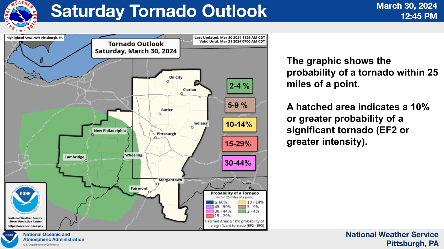
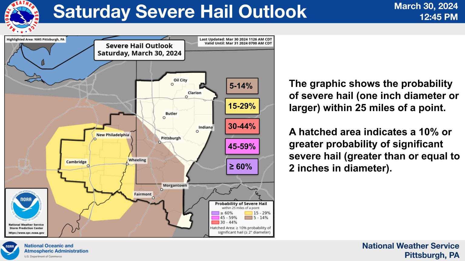
On the afternoon and evening of March 30th 2024, a surface low pressure system developed and lifted into the Lower Great Lakes region into northwestern OH/northern IN. As the surface low developed, southerly flow increased through the afternoon and evening and the warm front over the lower OH Valley lifted north into the Upper OH Valley. This brought warmer, moist, instable air into the region. A passing jet streak overhead set the stage for modest instability but impressive shear just behind the warm front into southern OH and into northern WV. Strong to severe thunderstorm began to develop in western OH and tracked southeast through southeast OH and northern WV. The main impacts were hail but the impressive shear allowed for decent organization and a couple supercells developed. The cell that tracked over Monroe County Ohio became more structurally impressive and warranted a tornado warning and actually produced a funnel cloud near Malaga, Ohio. The rest of the reports were hail and the bulk of the storms weakened and dissipated as they tracked into the southeast portions of the forecast area. |
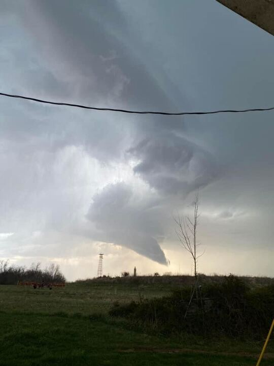 Photo Courtesy of Chastity Mellott of Malaga Ohio |
Photos
Watch
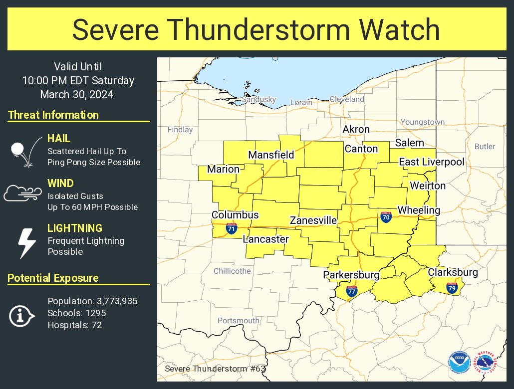 |
| Severe Thunderstorm Watch |
Radar
.gif) |
.gif) |
| Radar Loop 2031Z - 2211Z | Radar Loop 2219Z - 2356Z |
Storm Reports
 |
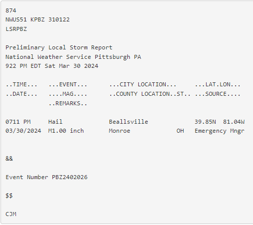 |
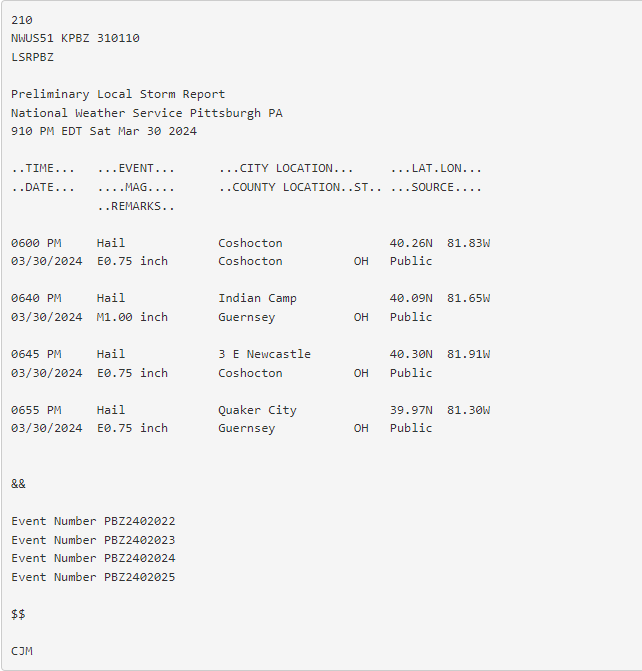
| Storm Reports | Storm Report |
Rain Reports
| Public Information Statement | ||||||
| National Weather Service Pittsburgh PA | ||||||
| 610 AM EDT Mon Apr 1 2024 | ||||||
| ...PRECIPITATION REPORTS FOR THE PAST 12 HOURS... | ||||||
| Location | Amount | Time | Date | Provider | ||
| ...Ohio... | ||||||
| ...Belmont County... | ||||||
| St. Clairsville | 0.85 | in | 503 | AM | 1-Apr | CWOP |
| 2.9 SW Mount Pleasant | 0.68 | in | 540 | AM | 1-Apr | IFLOWS |
| ...Carroll County... | ||||||
| Carrollton | 0.38 | in | 545 | AM | 1-Apr | CWOP |
| ...Coshocton County... | ||||||
| 3.0 SE Conesville | 1.27 | in | 545 | AM | 1-Apr | HADS |
| Nellie | 0.61 | in | 515 | AM | 1-Apr | HADS |
| Woodbury Wildlife Area | 0.44 | in | 555 | AM | 1-Apr | IFLOWS |
| 3 N Coshocton | 0.32 | in | 530 | AM | 1-Apr | IFLOWS |
| ...Guernsey County... | ||||||
| 1 NE Pleasant City | 1.62 | in | 500 | AM | 1-Apr | HADS |
| 3.3 SE Kimbolton | 1.33 | in | 545 | AM | 1-Apr | HADS |
| 2 E Senecaville | 0.63 | in | 515 | AM | 1-Apr | HADS |
| Kimbolton | 0.36 | in | 540 | AM | 1-Apr | IFLOWS |
| ...Harrison County... | ||||||
| 1 N New Athens | 0.64 | in | 540 | AM | 1-Apr | IFLOWS |
| 4 E Deersville | 0.56 | in | 545 | AM | 1-Apr | IFLOWS |
| Cadiz | 0.43 | in | 515 | AM | 1-Apr | HADS |
| ...Jefferson County... | ||||||
| 2 W Brentwood | 0.52 | in | 550 | AM | 1-Apr | IFLOWS |
| 1.1 NE Steubenville | 0.42 | in | 500 | AM | 1-Apr | HADS |
| ...Monroe County... | ||||||
| 0.6 W New Martinsville | 0.68 | in | 500 | AM | 1-Apr | HADS |
| 1 W Beallsville | 0.56 | in | 540 | AM | 1-Apr | IFLOWS |
| 2.7 E Woodsfield | 0.36 | in | 500 | AM | 1-Apr | HADS |
| Merrell Ridge | 0.32 | in | 532 | AM | 1-Apr | RAWS |
| ...Muskingum County... | ||||||
| Zanesville Airport | 1.41 | in | 553 | AM | 1-Apr | ASOS |
| 4 W Zanesville | 0.88 | in | 549 | AM | 1-Apr | AWS |
| Adamsville | 0.64 | in | 550 | AM | 1-Apr | IFLOWS |
| 4 NW Zanesville | 0.5 | in | 515 | AM | 1-Apr | HADS |
| ...Noble County... | ||||||
| 2.0 E Sarahsville | 0.55 | in | 400 | AM | 1-Apr | IFLOWS |
| Summerfield | 0.44 | in | 530 | AM | 1-Apr | IFLOWS |
| 3 W Caldwell | 0.28 | in | 525 | AM | 1-Apr | IFLOWS |
| ...Tuscarawas County... | ||||||
| New Philadelphia | 0.54 | in | 545 | AM | 1-Apr | CWOP |
| 1.0 S Uhrichsville | 0.54 | in | 500 | AM | 1-Apr | HADS |
| New Philadelphia Airport | 0.38 | in | 553 | AM | 1-Apr | ASOS |
| Zoar | 0.25 | in | 515 | AM | 1-Apr | HADS |
| ...Pennsylvania... | ||||||
| ...Allegheny County... | ||||||
| 2 SW Bridgeville | 0.55 | in | 550 | AM | 1-Apr | AWS |
| Dawson | 0.48 | in | 546 | AM | 1-Apr | CWOP |
| Carnegie | 0.43 | in | 549 | AM | 1-Apr | CWOP |
| Imperial | 0.43 | in | 545 | AM | 1-Apr | CWOP |
| 0.9 NE Green Tree | 0.36 | in | 500 | AM | 1-Apr | IFLOWS |
| Pittsburgh Intl Airport | 0.34 | in | 551 | AM | 1-Apr | ASOS |
| Emsworth | 0.33 | in | 550 | AM | 1-Apr | AWS |
| 1 WSW Plum | 0.31 | in | 555 | AM | 1-Apr | AWS |
| Moon Township | 0.3 | in | 548 | AM | 1-Apr | CWOP |
| Pittsburgh | 0.28 | in | 546 | AM | 1-Apr | CWOP |
| ...Armstrong County... | ||||||
| 1 NNE New Kensington | 0.32 | in | 542 | AM | 1-Apr | CWOP |
| FREEPORT | 0.31 | in | 547 | AM | 1-Apr | CWOP |
| 3.5 S Lenape Heights | 0.25 | in | 545 | AM | 1-Apr | HADS |
| ...Beaver County... | ||||||
| Fombell | 0.31 | in | 546 | AM | 1-Apr | CWOP |
| ...Butler County... | ||||||
| 1 N Harmony | 0.27 | in | 550 | AM | 1-Apr | AWS |
| ...Fayette County... | ||||||
| 2.4 W Juniata | 0.45 | in | 545 | AM | 1-Apr | HADS |
| 6 SW Ohiopyle | 0.4 | in | 500 | AM | 1-Apr | HADS |
| Connellsville Airport | 0.38 | in | 535 | AM | 1-Apr | AWOS |
| ...Greene County... | ||||||
| 1 ESE Graysville | 0.72 | in | 500 | AM | 1-Apr | HADS |
| Waynesburg | 0.64 | in | 549 | AM | 1-Apr | CWOP |
| Waynesburg | 0.64 | in | 546 | AM | 1-Apr | CWOP |
| ...Indiana County... | ||||||
| 4 E Saltsburg | 0.26 | in | 530 | AM | 1-Apr | HADS |
| ...Washington County... | ||||||
| Avella | 0.63 | in | 545 | AM | 1-Apr | HADS |
| ...Westmoreland County... | ||||||
| 1 NW Jeannette | 0.52 | in | 530 | AM | 1-Apr | HADS |
| 3 SE White Oak | 0.47 | in | 550 | AM | 1-Apr | AWS |
| 1 NW Ligonier | 0.46 | in | 545 | AM | 1-Apr | HADS |
| North Charleroi | 0.39 | in | 500 | AM | 1-Apr | HADS |
| Apollo | 0.33 | in | 546 | AM | 1-Apr | CWOP |
| 2 S Saltsburg | 0.27 | in | 515 | AM | 1-Apr | HADS |
| 0.5 NW Seward | 0.25 | in | 545 | AM | 1-Apr | HADS |
| ...West Virginia... | ||||||
| ...Brooke County... | ||||||
| 3 N West Liberty | 0.96 | in | 500 | AM | 1-Apr | USGS |
| Archer Heights | 0.52 | in | 505 | AM | 1-Apr | IFLOWS |
| ...Hancock County... | ||||||
| Kings Creek | 0.76 | in | 500 | AM | 1-Apr | IFLOWS |
| ...Marion County... | ||||||
| 4.9 N Grafton | 0.28 | in | 500 | AM | 1-Apr | IFLOWS |
| ...Marshall County... | ||||||
| 2 NE Moundsville | 1.12 | in | 525 | AM | 1-Apr | IFLOWS |
| Cameron | 1 | in | 515 | AM | 1-Apr | HADS |
| 4.1 NW Littleton | 1 | in | 540 | AM | 1-Apr | IFLOWS |
| 5 S Valley Grove | 0.76 | in | 500 | AM | 1-Apr | IFLOWS |
| ...Monongalia County... | ||||||
| MORGANTOWN | 0.7 | in | 547 | AM | 1-Apr | CWOP |
| 4.1 NE Fairview | 0.6 | in | 555 | AM | 1-Apr | IFLOWS |
| Morgantown | 0.57 | in | 546 | AM | 1-Apr | CWOP |
| Morgantown | 0.45 | in | 546 | AM | 1-Apr | CWOP |
| 3 S Wadestown | 0.4 | in | 545 | AM | 1-Apr | IFLOWS |
| Morgantown Airport | 0.39 | in | 553 | AM | 1-Apr | ASOS |
| 1.1 SE Westover | 0.38 | in | 515 | AM | 1-Apr | HADS |
| ...Ohio County... | ||||||
| Bethlehem | 0.68 | in | 545 | AM | 1-Apr | IFLOWS |
| 2 S Valley Grove | 0.6 | in | 550 | AM | 1-Apr | IFLOWS |
| Wheeling Airport | 0.59 | in | 553 | AM | 1-Apr | ASOS |
| Yorkville | 0.58 | in | 500 | AM | 1-Apr | HADS |
| 1.7 E Bethlehem | 0.54 | in | 515 | AM | 1-Apr | HADS |
| Wheeling | 0.45 | in | 545 | AM | 1-Apr | CWOP |
| ...Preston County... | ||||||
| 3.9 N Bruceton Mills | 1.08 | in | 545 | AM | 1-Apr | IFLOWS |
| 6.6 SE Brandonville | 1 | in | 555 | AM | 1-Apr | IFLOWS |
| Bruceton Mills | 0.72 | in | 515 | AM | 1-Apr | HADS |
| ...Wetzel County... | ||||||
| 5 E New Martinsville | 0.6 | in | 515 | AM | 1-Apr | IFLOWS |
| 3.2 S Smithfield | 0.28 | in | 200 | AM | 1-Apr | IFLOWS |
| 1 SE Hundred | 0.28 | in | 515 | AM | 1-Apr | HADS |
Environment
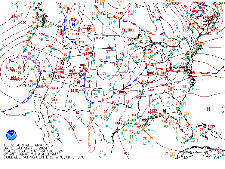
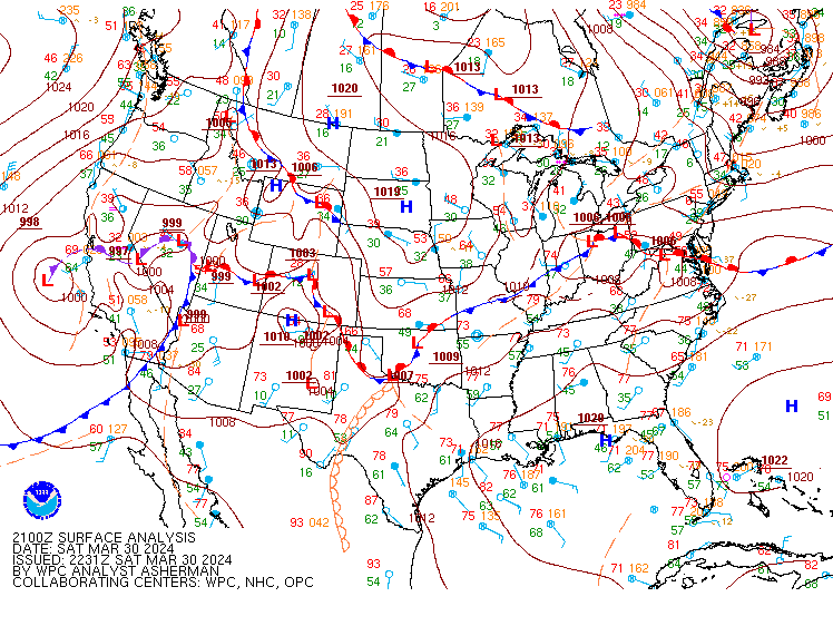
Surface Analysis Map from WPC.
 |
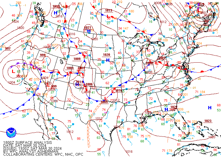 |
| March 30th 2024 15Z SFC | March 30th 18Z SFC |
 |
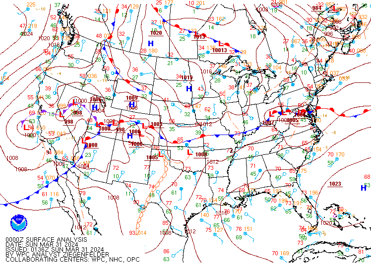 |
| March 30th 2024 21Z SFC | March 31st 2024 00Z SFC |
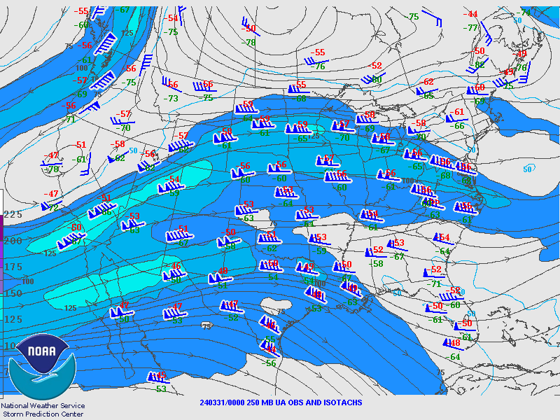
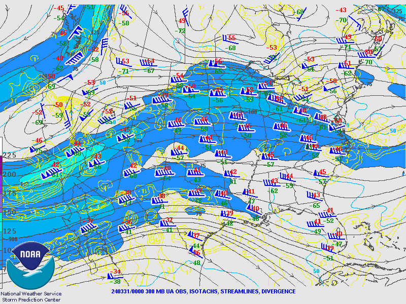
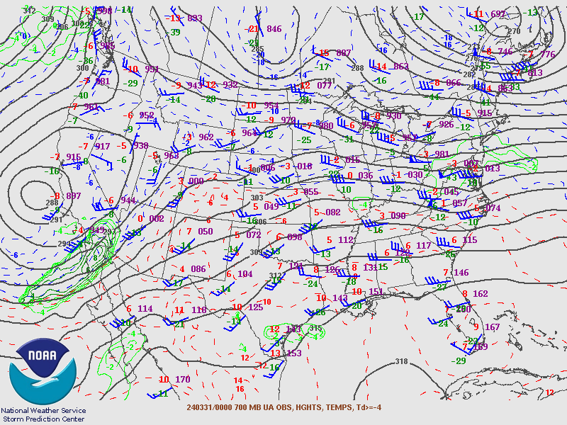
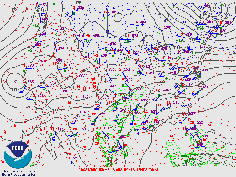
Upper Air Maps from SPC.
March 31st 2024 00Z Maps
 |
 |
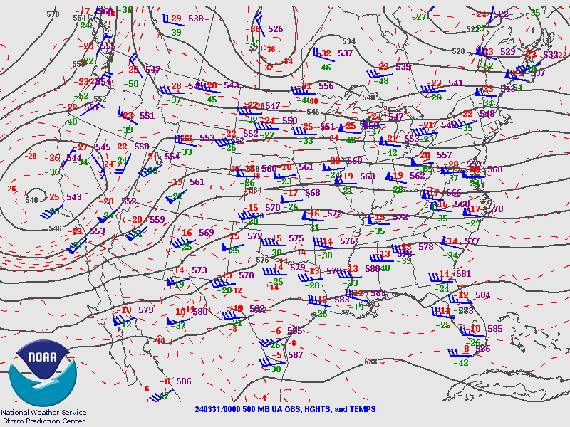 |
| 250MB | 300MB | 500MB |
 |
 |
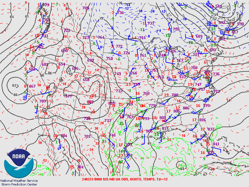 |
| 700MB | 850MB | 925MB |
Skew-T from KPIT.
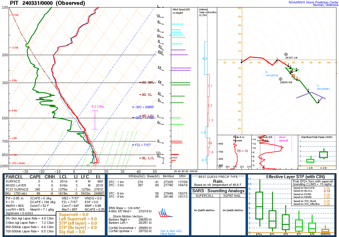 |
| 240331 00Z Sounding |
Additional Information
Outlooks
 |
 |
 |
| SPC Day 1 Categorical Outlook | SPC Day 1 Tornado Outlook | SPC Day 1 Hail Outlook |
 |
Media use of NWS Web News Stories is encouraged! Please acknowledge the NWS as the source of any news information accessed from this site. |
|

