 |
|
Latest Emergency Manager's Briefing (pdf) NO! This briefing is updated when hazardous weather is expected or occurring. |
| Graphical Hazardous Weather Outlook | Days 1-8 Severe Weather Outlooks | Days 1-3 Excessive Rainfall Outlooks |
 Charleston, WV | Sterling, VA | State College, PA | Cleveland, OH | Wilmington, WV Charleston, WV | Sterling, VA | State College, PA | Cleveland, OH | Wilmington, WV |
 |
 |
Weather Hazards Outlook
|
820 FLUS41 KPBZ 211718 HWOPBZ Hazardous Weather Outlook National Weather Service Pittsburgh PA 118 PM EDT Tue Jul 21 2026 PAZ007>009-013-015-016-221730- Mercer-Venango-Forest-Lawrence-Clarion-Jefferson PA- 118 PM EDT Tue Jul 21 2026 This Hazardous Weather Outlook is for western Pennsylvania. .DAY ONE...This afternoon and tonight. A new disturbance is expected to impact the region today. Flash flooding and/or severe storms that produce damaging winds, hail, and tornadoes may occur between 12pm and 8pm. .DAYS TWO THROUGH SEVEN...Wednesday through Monday. No hazardous weather is expected at this time. .SPOTTER INFORMATION STATEMENT... Spotter activation is not expected at this time. $$ PAZ014-022-077-078-221730- Butler-Armstrong-Indiana-Higher Elevations of Indiana- 118 PM EDT Tue Jul 21 2026 ...FLOOD WATCH IN EFFECT UNTIL 11 PM EDT THIS EVENING... This Hazardous Weather Outlook is for western Pennsylvania. .DAY ONE...This afternoon and tonight. Please listen to NOAA Weather Radio or go to weather.gov on the Internet for more information about the following hazards. Flood Watch. A new disturbance is expected to impact the region today. Flash flooding and/or severe storms that produce damaging winds, hail, and tornadoes may occur between 12pm and 8pm. .DAYS TWO THROUGH SEVEN...Wednesday through Monday. No hazardous weather is expected at this time. .SPOTTER INFORMATION STATEMENT... Spotter activation is not expected at this time. $$ OHZ040-041-049-050-058-059-068-069-PAZ020-021-029-031-073>076- WVZ001>004-012-021-509>514-221730- Carroll-Columbiana-Harrison-Jefferson OH-Guernsey-Belmont-Noble- Monroe-Beaver-Allegheny-Washington-Greene-Westmoreland- Higher Elevations of Westmoreland-Fayette- Higher Elevations of Fayette-Hancock-Brooke-Ohio-Marshall-Wetzel- Marion-Monongalia- Ridges of Eastern Monongalia and Northwestern Preston-Preston- Eastern Preston-Western Tucker-Eastern Tucker- 118 PM EDT Tue Jul 21 2026 ...FLOOD WATCH IN EFFECT UNTIL 11 PM EDT THIS EVENING... ...SEVERE THUNDERSTORM WATCH 506 IN EFFECT UNTIL 8 PM EDT THIS EVENING... This Hazardous Weather Outlook is for east central Ohio, southwest Pennsylvania, western Pennsylvania, and northern West Virginia. .DAY ONE...This afternoon and tonight. Please listen to NOAA Weather Radio or go to weather.gov on the Internet for more information about the following hazards. Flood Watch. Severe Thunderstorm Watch. .DAYS TWO THROUGH SEVEN...Wednesday through Monday. No hazardous weather is expected at this time. .SPOTTER INFORMATION STATEMENT... Spotter activation is not expected at this time. $$ OHZ039-048-057-221730- Tuscarawas-Coshocton-Muskingum- 118 PM EDT Tue Jul 21 2026 ...SEVERE THUNDERSTORM WATCH 506 IN EFFECT UNTIL 8 PM EDT THIS EVENING... This Hazardous Weather Outlook is for east central Ohio. .DAY ONE...This afternoon and tonight. Please listen to NOAA Weather Radio or go to weather.gov on the Internet for more information about the following hazards. Severe Thunderstorm Watch. .DAYS TWO THROUGH SEVEN...Wednesday through Monday. No hazardous weather is expected at this time. .SPOTTER INFORMATION STATEMENT... Spotter activation is not expected at this time. $$ AK |
Observed Weather Briefing
 |
 Regional Radar Loop |
 NWS Pittsburgh, PA Radar Loop |
 Cleveland, OH |
 Wilmington, OH |
 State College, PA |
 Sterling, VA |
 Charleston, WV |
 Buffalo, NY |
||
| Click Here for Interactive Radar Display | ||||
 GeoColor Satellite Image |
 Infrared Satellite Image Infrared Satellite Image |
 Water Vapor Image |
| Additional Satellite Imagery |
 US Surface Analysis |
 US Surface Analysis with Radar |
 US Surface Temps | N America | World |
Rainfall and Flood Threat Briefing
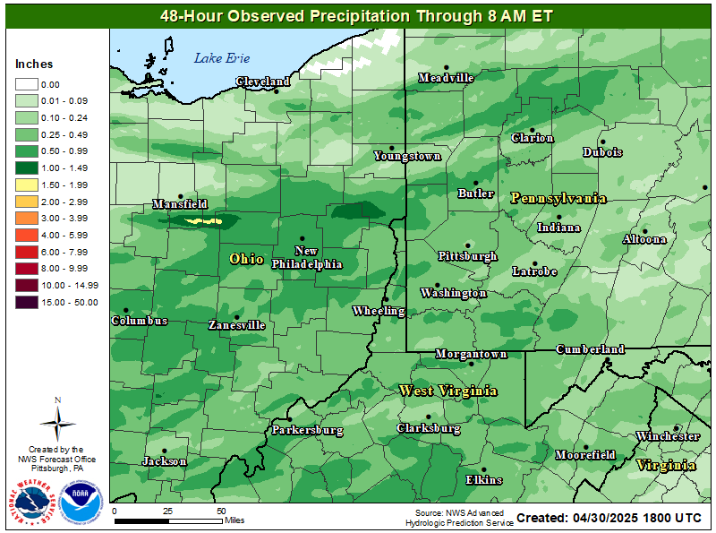
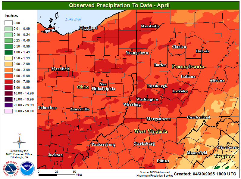
| How Much Rain Has Fallen? (Interactive) | |
 |
 |
| 72-Hour Forecasted Liquid Precipitation | 72-Hour 10th Percentile (Low-End) Liquid Precipitation Forecast | 72-Hour 90th Percentile (High-End) Liquid Precipitation Forecast | |
 |
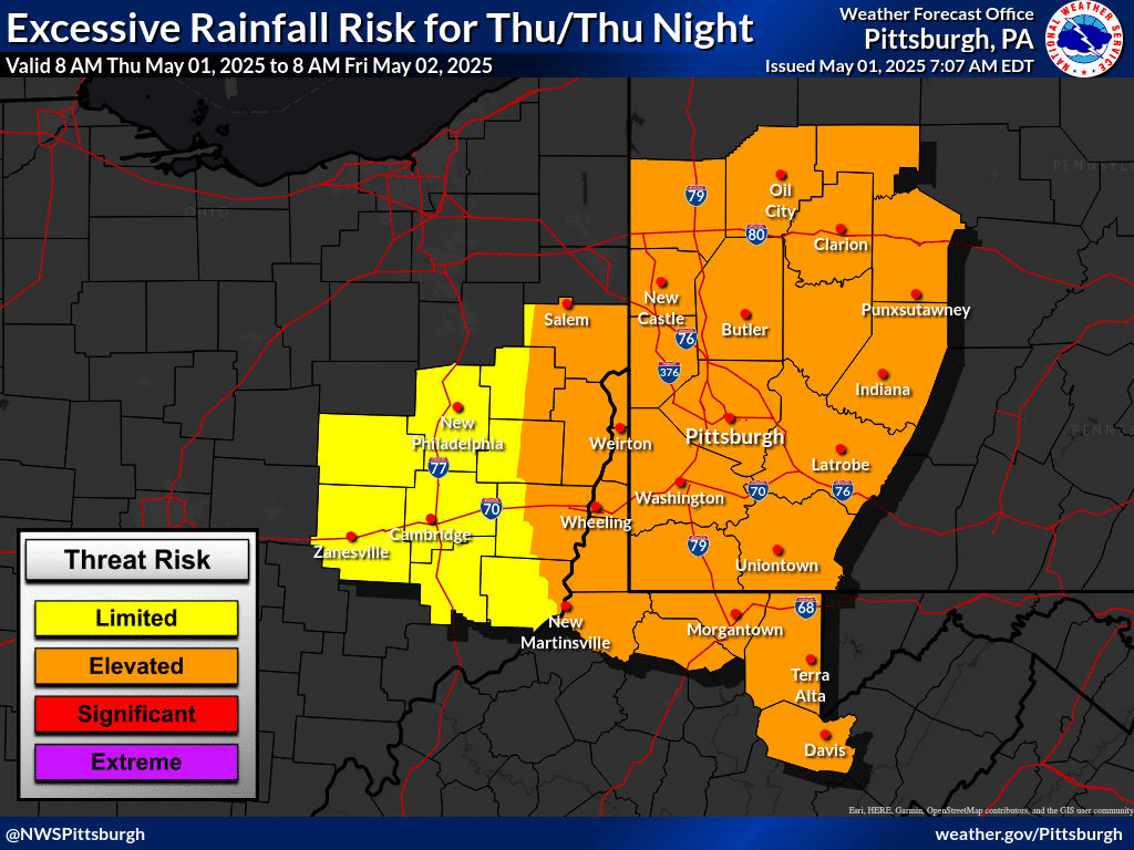
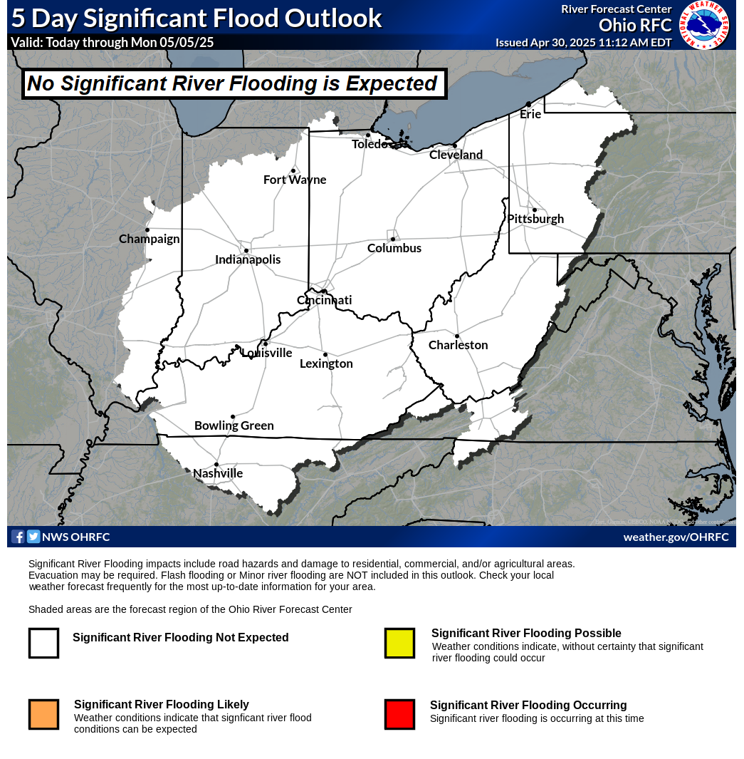
| Day 1 Excessive Rainfall Outlook | Day 2 Excessive Rainfall Outlook | Day 3 Excessive Rainfall Outlook | Ohio River Basin Flood Outlook |
 |
 |
 |
 |

| Day 1 Precipitation | Day 2 Precipitation | Day 3 Precipitation |
 |
 |
 |
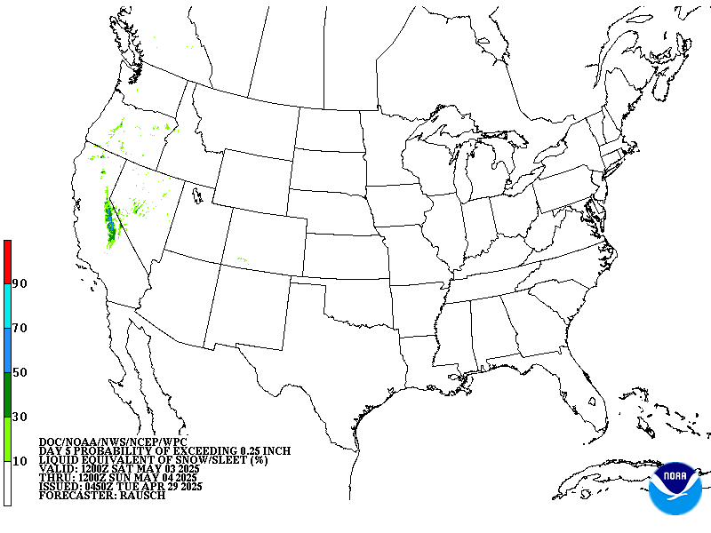
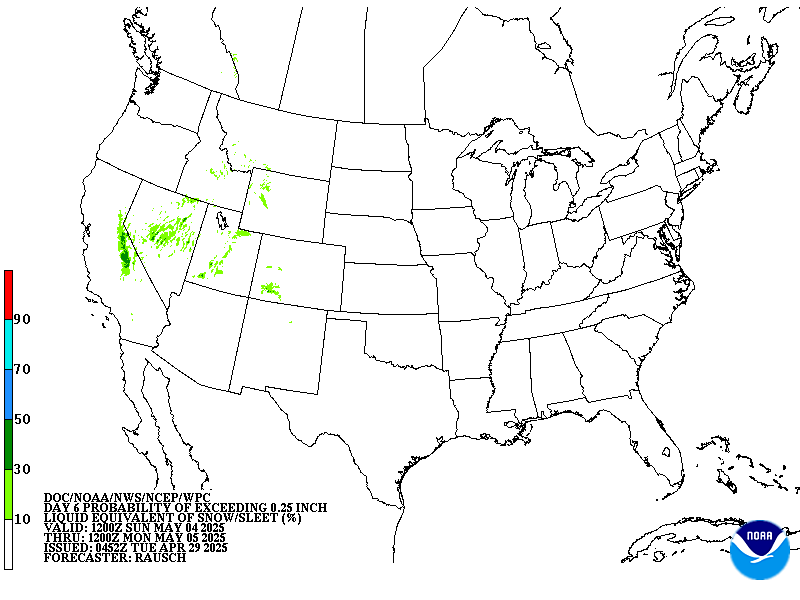
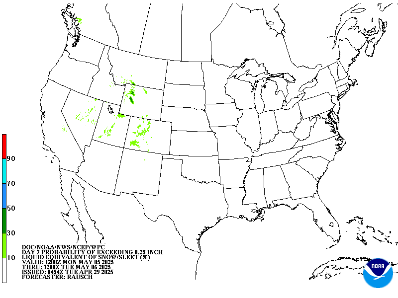
| Day 4-5 Precipitation | Day 6-7 Precipitation | 7-Day Total Precipitation |
 |
 |
 |
Thunderstorm Threat Briefing
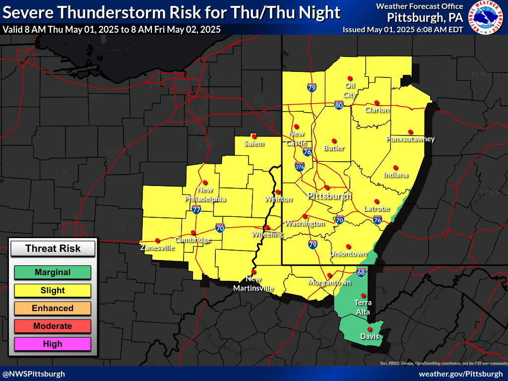
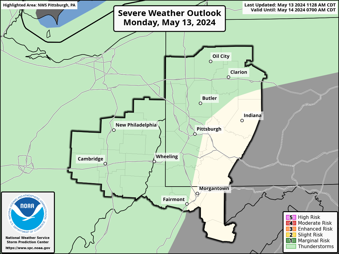
| Day 1 Local Severe Weather Outlooks | |||
 |
 |
 |
 |
| Additional SPC Day 1 Outlook Details | |||
| Day 2 Local Severe Weather Outlooks | |||
 |
 |
 |
 |
| Additional SPC Day 2 Outlook Information | |||
| Day 3 Local Severe Weather Outlooks | |
 |
 |
| Additional SPC Day 3 Outlook Information | |

 |
Current Watches |
Storm Trend Discussions |
Today's Storm Reports |
Yesterday's Storm Reports |
| SPC Day 1 Thunderstorm Outlook | SPC Day 1 Tornado Outlook | SPC Day 1 Severe Wind Outlook | SPC Day 1 Severe Hail Outlook |
 |
 |
 |
 |
| SPC Day 1 Thunderstorm Outlook Discussion | |||
| SPC Day 2 Thunderstorm Outlook | SPC Day 2 Tornado Outlook | SPC Day 2 Severe Wind Outlook | SPC Day 2 Severe Hail Outlook |
 |
 |
 |
 |
| SPC Day 2 Thunderstorm Outlook Discussion | |||
| SPC Day 3 Thunderstorm Outlook | SPC Day 4-8 Thunderstorm Outlook |
 |
 |
| SPC Day 3 Outlook Narrative | SPC Day 4-8 Outlook Narrative |
Winter Weather Threat Briefing
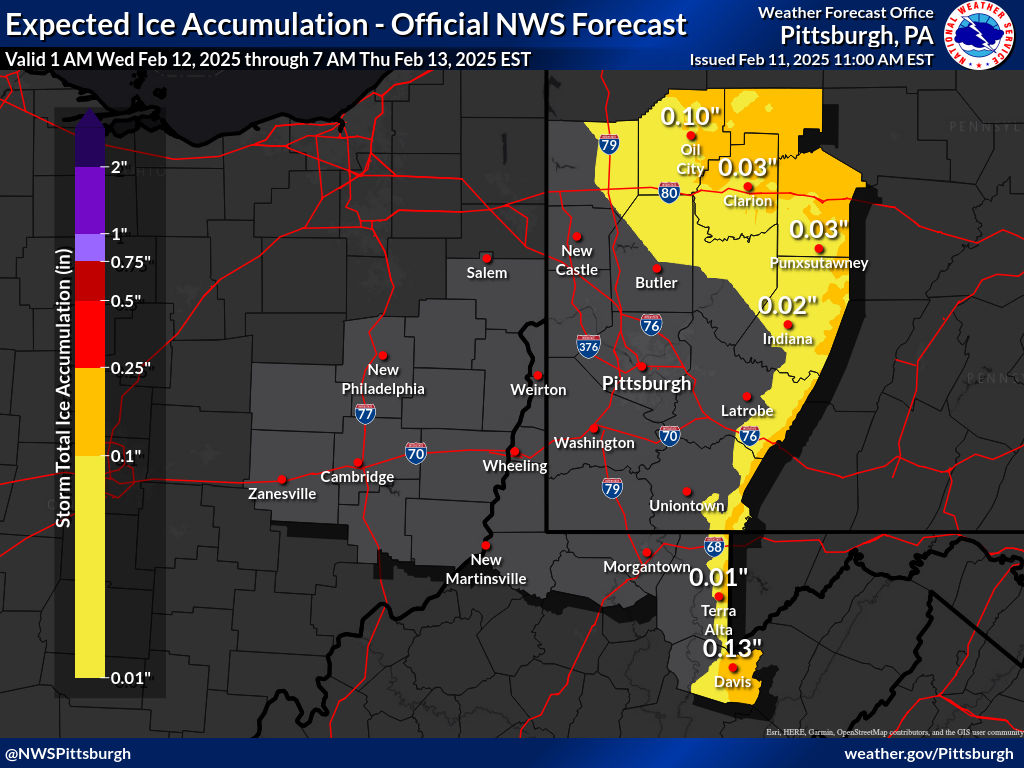
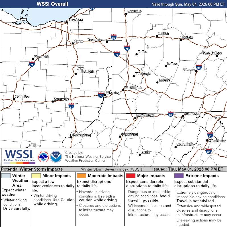
| 72-Hour Snowfall Forecast | Expected Ice Accumulation Forecast | Winter Storm Severity Index | |
 |
 |
|
| 10th Percentile (Low-End) Snowfall Forecast | 90th Percentile (High-End) Snowfall Forecast |
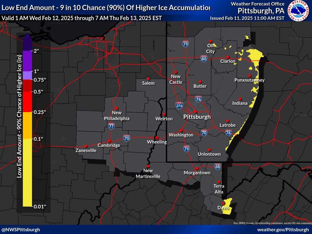
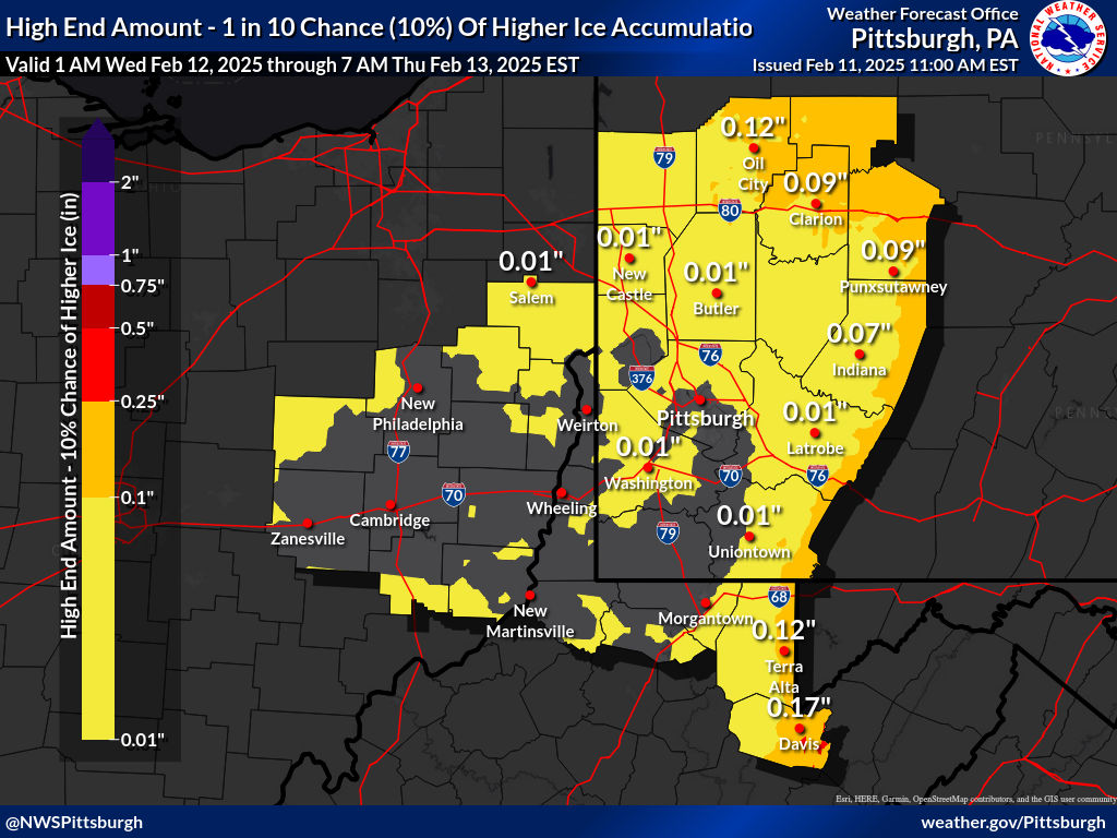
| 10th Percentile (Low-End) Ice Accumulation Forecast | 90th Percentile (High-End) Ice Accumulation Forecast |
 |
 |
| 30 Hour Forecast Snow Amounts (6 Hour Periods) | ||||||
| 0 to 6 Hours | 6 to 12 Hours | 12 to 18 Hours | 18 to 24 Hours | 24 to 30 Hours | 30 to 36 Hours | |
 |
 |
 |
 |
 |
 |
|
| Day 1 Snowfall Greater Than 4" | Day 2 Snowfall Greater Than 4" | Day 3 Snowfall Greater Than 4" |
 |
 |
 |
| Day 1 Freezing Rain Greater than 1/4" | Day 2 Freezing Rain Greater than 1/4" | Day 3 Freezing Rain Greater than 1/4" |
 |
 |
 |
| Day 4 Experimental Winter Weather Outlook | Day 5 Experimental Winter Weather Outlook | Day 6 Experimental Winter Weather Outlook | Day 7 Experimental Winter Weather Outlook |
 |
 |
 |
 |
Temperature and Wind Threat Briefing
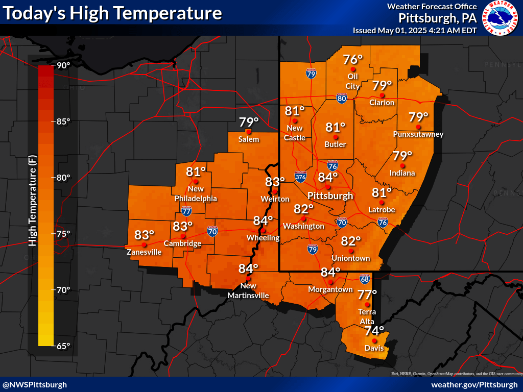
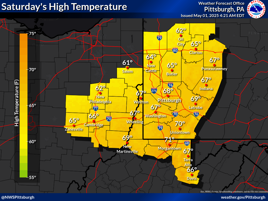
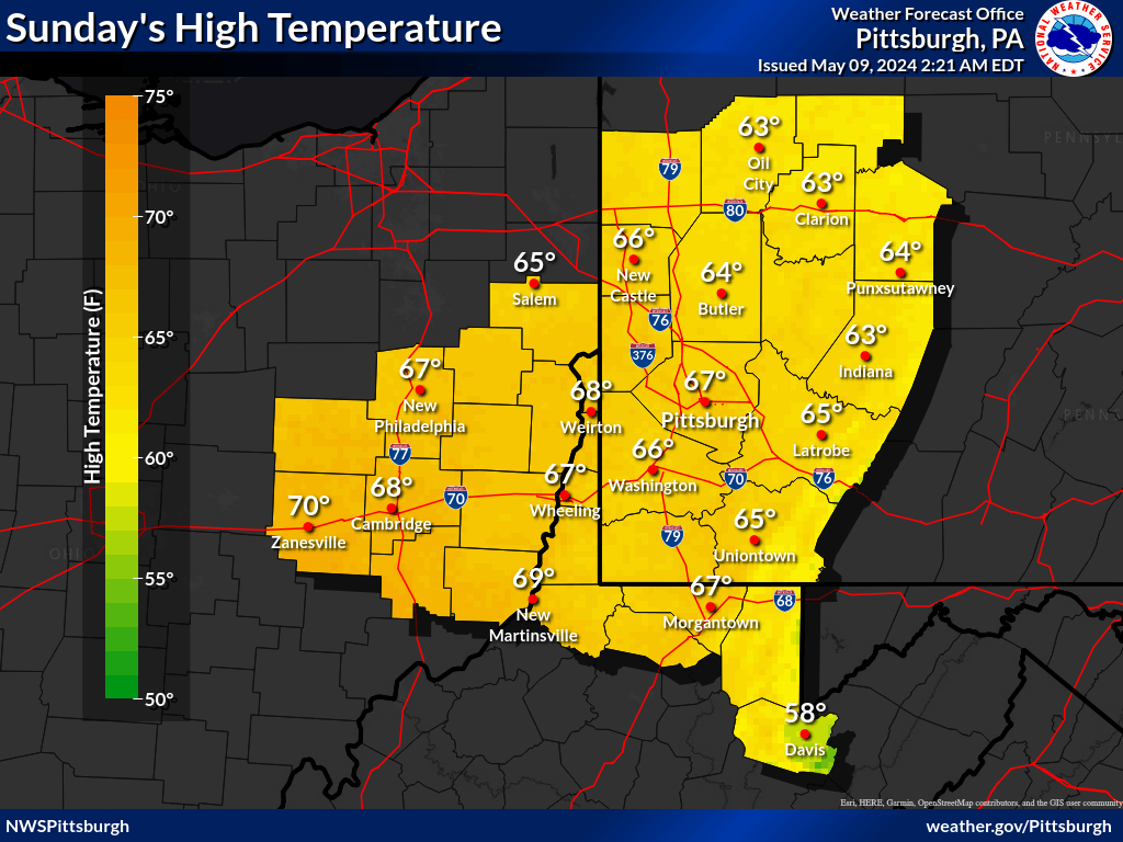
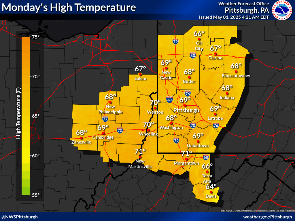
| Today's High Temperatures | Tomorrow's High Temperatures | Day 3 High Temperatures | Day 4 High Temperatures | Day 5 High Temperatures |
 |
 |
 |
 |
 |
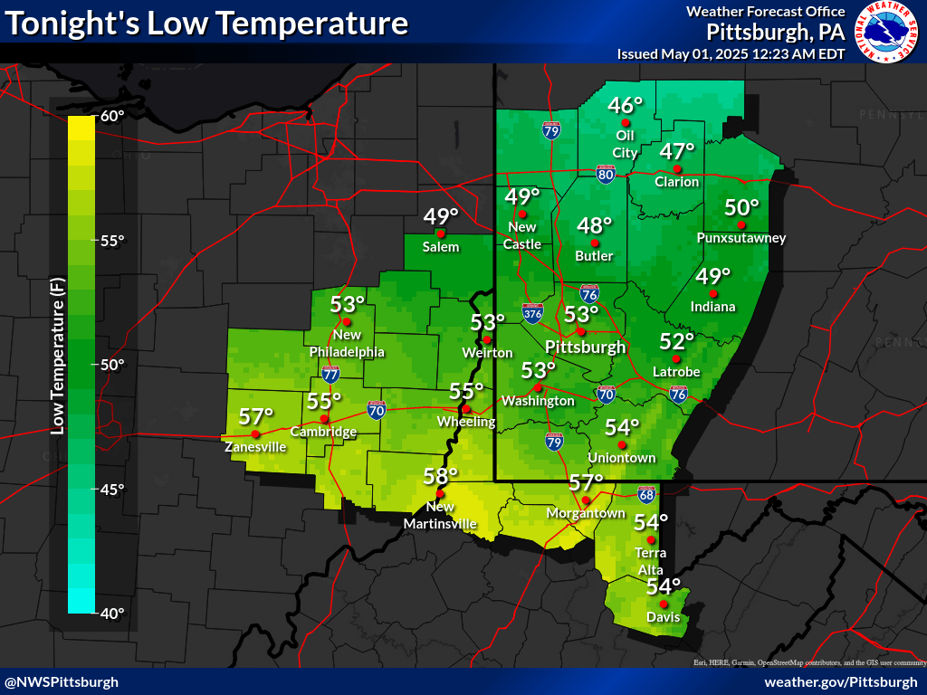
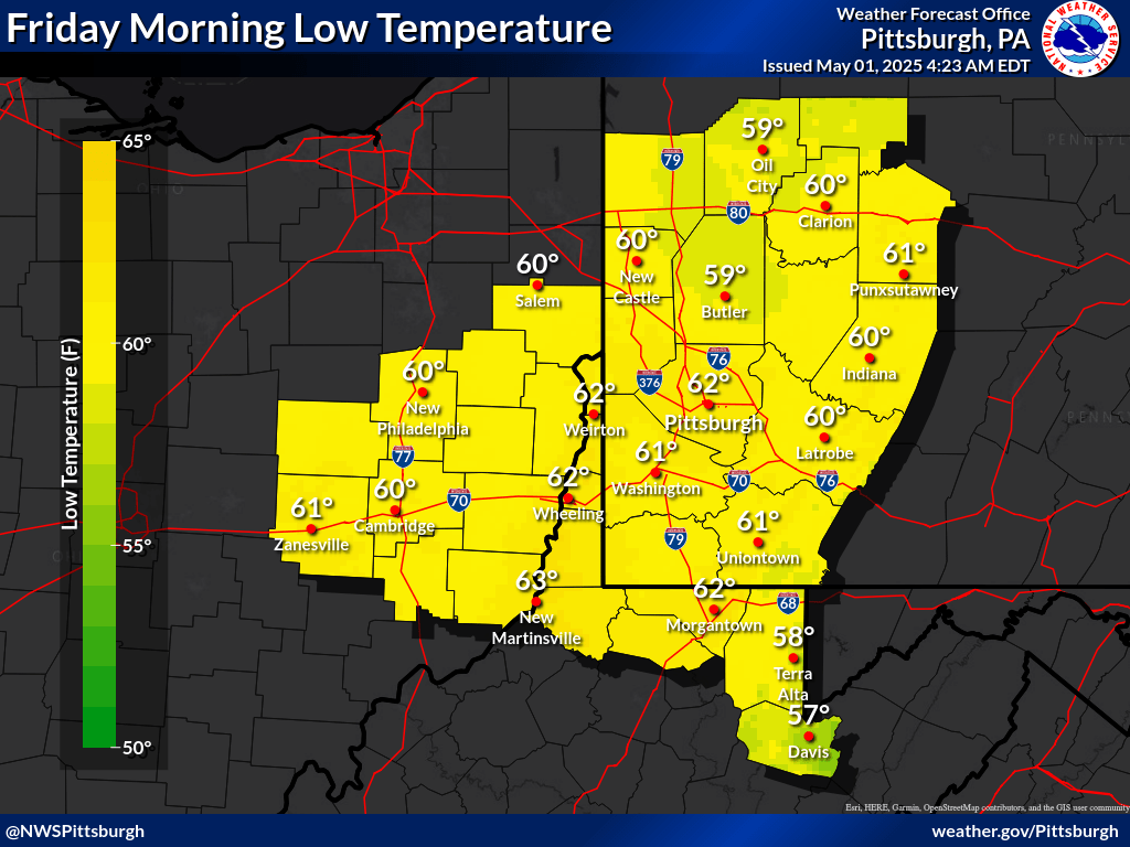
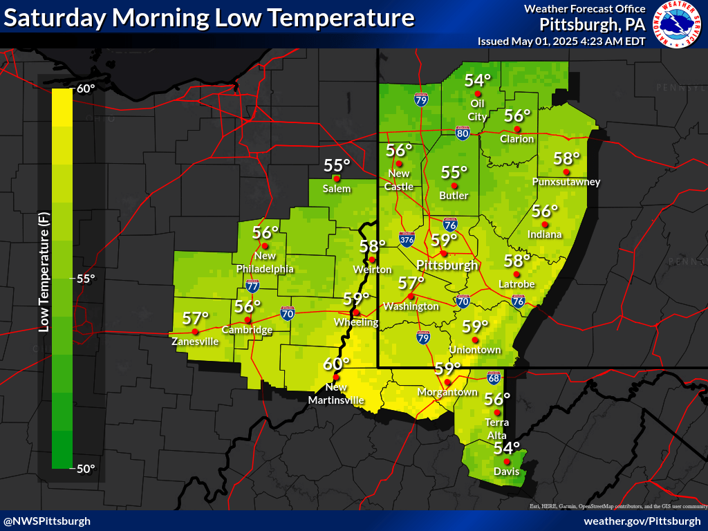
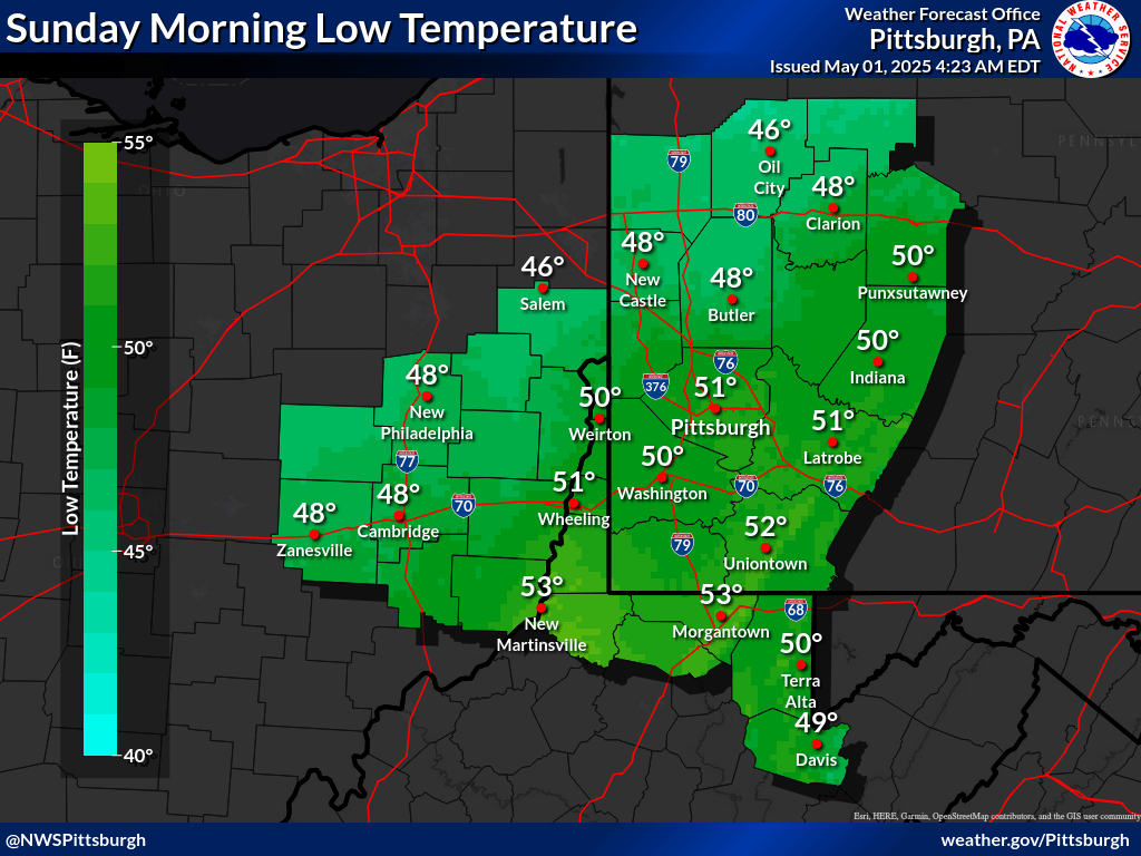
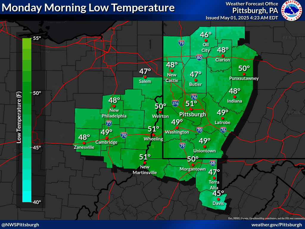
| Today's Low Temperatures | Tonight's Low Temperatures | Day 3 Low Temperatures | Day 4 Low Temperatures | Day 5 Low Temperatures |
 |
 |
 |
 |
 |
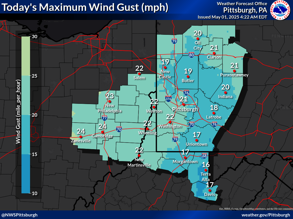
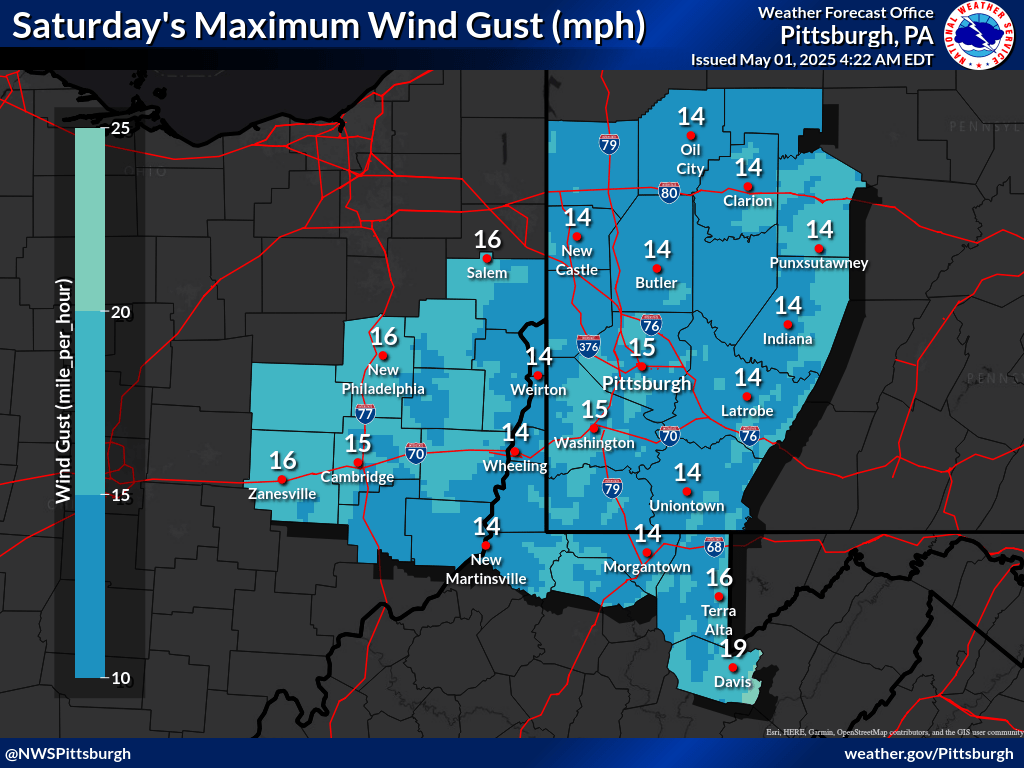
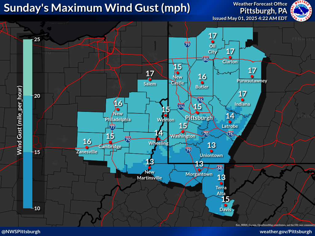
| Today's Max Wind Gusts | Tomorrow's Max Wind Gusts | Day 3's Max Wind Gusts | Day 4's Max Wind Gusts |
 |
 |
 |
 |
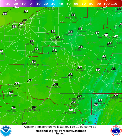
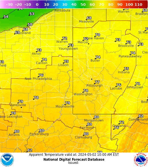
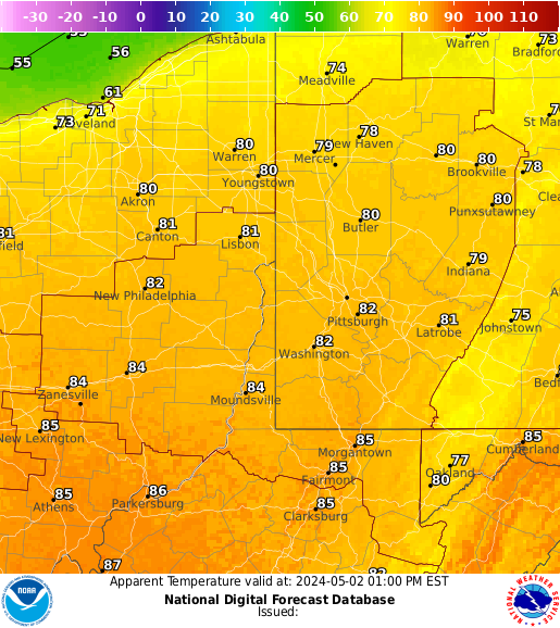
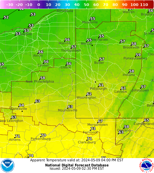
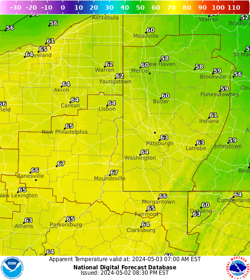
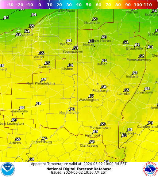
| 3 Hourly Apparent Temperature |
 |
 |
 |
 |
 |
 |
|
Drought and Fire Weather Threat Briefing
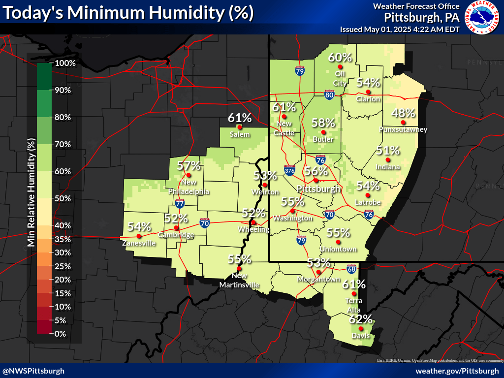
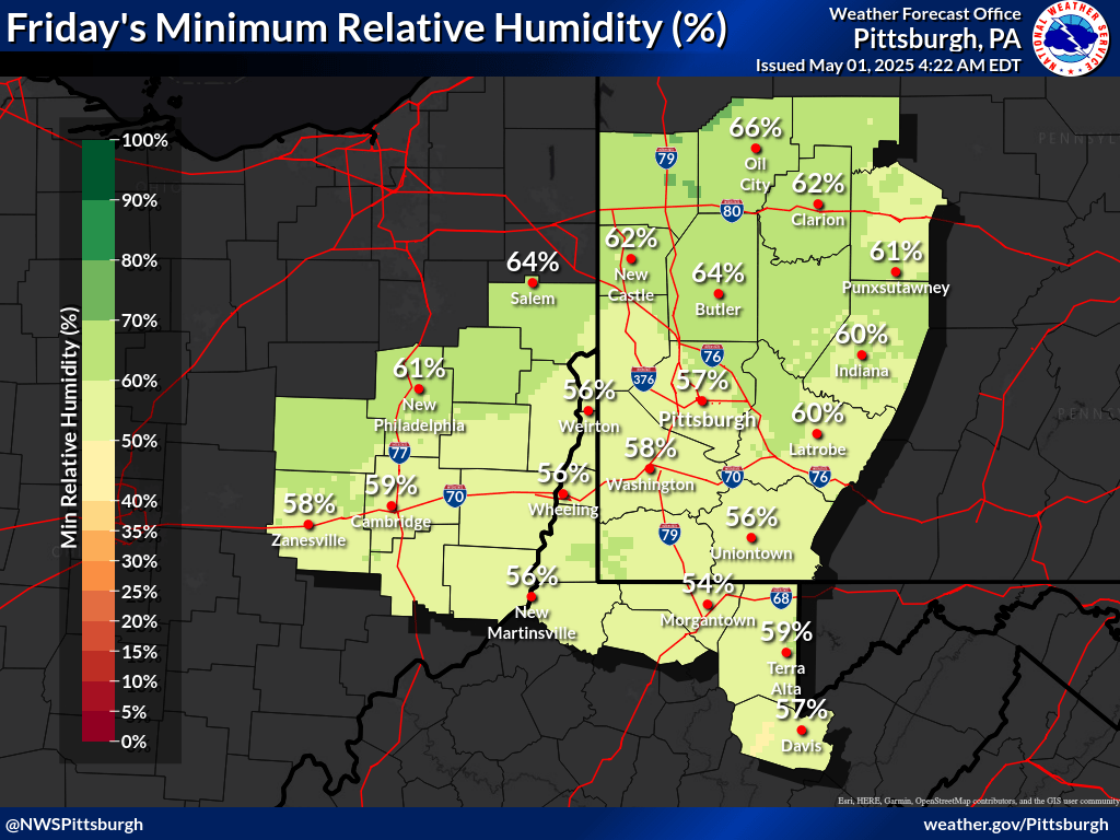
| Today's Minimum Humidity | Tomorrow's Minimum Humidity |
 |
 |
| Today/Tonight Max Wind Gusts | Tomorrow/Tomorrow Night Max Wind Gusts |
|
|
WFAS Observed Fire Danger Rating |
WFAS Forecast Fire Danger Rating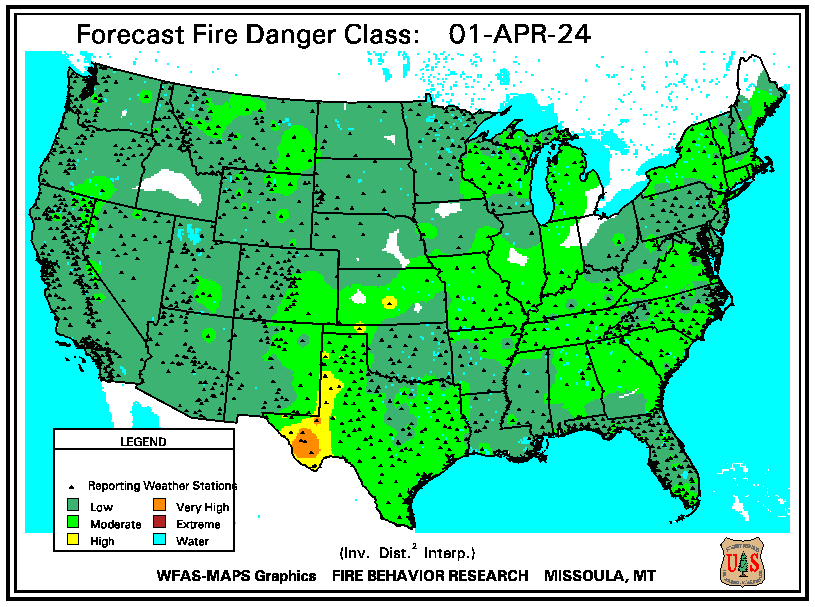 |
| SPC Fire Weather Day 1 Outlook | SPC Fire Weather Day 2 Outlook | SPC Fire Weather Day 3-8 Outlook |
 |
 |
 |
 |
 |
| Seasonal Drought Outlook | NICC Significant Fire Potential Outlook |
 |
 |
Long Range Outlook Briefing
| Days 3-7 Hazards Outlook (WPC) |
 |
| Days 8-14 Hazards Outlook (CPC) | Days 8-14 Risk of Hazardous Temperatures (CPC) | Days 8-14 Risk of Heavy Precipitation (CPC) |
 |
 |
 |
| 6-10 Day Temperature Outlook (CPC) | 6-10 Day Precipitation Outlook (CPC) |
 |
 |
| 8-14 Day Temperature Outlook (CPC) | 8-14 Day Precipitation Outlook (CPC) |
 |
 |
| **Experimental** Week 3-4 Temperature Outlook (CPC) | **Experimental** Week 3-4 Precipitation Outlook (CPC) |
 |
 |
| One Month Temperature Outlook (CPC) | One Month Precipitation Outlook (CPC) |
 |
 |
| Three Month Temperature Outlook (CPC) | Three Month Precipitation Outlook (CPC) |
 |
 |


