
A slow moving front will be the focus area for heavy to excessive rainfall and a threat for flash/urban flooding across the northern Gulf Coast and Southeast U.S. through this weekend. Abnormally hot, potentially record-breaking, temperatures will impact southern California and stretch north toward the Bay Area and Central Valley into next week. Read More >
Pittsburgh, PA
Weather Forecast Office
The November 11, 2002 Mercer County Tornado
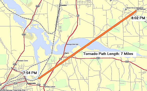
On November 11, 2002 an F2 (EF-3) tornado touched down in Mercer county at 754pm. The tornado reached the ground on Trout Island Road, East of Sharpsville. Following touchdown, the tornado moved northeast across Route 18 and ripped through the community of Clark. The storm continued to proceed northeastward across the Shenango River and moved into New Hamburg before dissipating at 802pm.
This tornado cut a path 500 yards wide and remained on the ground for 7 miles. Maximum wind speed was an estimated 155 mph (F2) (EF-3).
This was the strongest tornado to hit Mercer county since the outbreak of May 31, 1985.
Forecast
PIT Weather Radio
PIT Hydrology
Sun/Moon
National Fire Weather
Severe Weather
Hurricanes
River/Stream
National Marine
National Aviation
Graphical
Discussions
NBM 1D Viewer
Astronomical Data
PIT Fire Weather
PIT Aviation Page
Enhanced Hazardous Weather Outlook
Hydrology
PIT Hydrology Page
Ohio River Forecast Center
National Office of Water Prediction
Reports
Report Severe Weather
Local Storm Reports
Public Information Statement
Winter Weather
Climate
Past Weather
PA State Climatologist
Climate Predictions
Past Events
Local Climate Page
Skywarn
Skywarn Page
What is Skywarn?
Skywarn Meetings
Ham Radio Frequencies
Ham Radio Program
Weather Safety
NOAA Weather Radio
Pittsburgh Weather Radio
Brochures
FEMA
Red Cross
Damage/Fatality/Injury Statistics
Thunderstorm Safety
Air Quality
Winter Safety
Turn Around Don't Drown
Flood Safety
Tornado Safety
Lightning Safety
Heat Safety
Storm Ready
UV (Sun) Safety
Office Programs
Pittsburgh Facebook Page
Pittsburgh X Feed
CoOP
Meteorological Calculator
Online Office Tour
Social Media Feeds
Office History
NWS News
NWS News
Pubs/Brochures/Booklets
Social Media
Events
Organizational Information
About
Glossary
Products and Services
National Centers
NOAA International
Contact Us

US Dept of Commerce
National Oceanic and Atmospheric Administration
National Weather Service
Pittsburgh, PA
192 Shafer Road
Moon Township, PA 15108
412-262-2170
Comments? Questions? Please Contact Us.


 Radar
Radar Current Weather
 Rivers & Lakes
 Satellite
 Forecast Maps
 Hour by Hour Forecast
 Tropical Weather
 Graphical Hazards
 Weather Hazards Briefing
 Forecaster's Discussion
 Text Bulletins
 Climate Data
 Skywarn
 Submit Storm Report
 Fire Weather
 NOAA Weather Radio
 Aviation
 Follow us on X
 Follow us on Facebook
 PBZ RSS Feed