
Wildfire smoke will push into the Midwest, worsening air quality. A frontal system brings severe storms from the Northern Plains to the Mid‑Atlantic the next few days. Heavy Gulf Coast rain is possible as Tropical Depression Two has formed, while monsoonal storms persist in the Southwest with heavy rainfall. Hazardous heat expands from the Plains into the Lower Mississippi Valley. Read More >
 Winter Weather
 Local Products
Winter Products from National Centers
Watch/Warning/Advisory Terminology & Criteria
| Criteria Maps of Winter Storm Watches, Warnings & Advisories for New Jersey, eastern Pennsylvania, Delaware, eastern Maryland | |
| 12-Hour Advisory Snowfall | |
| 12-Hour Warning Snowfall | |
| 24-Hour Warning Snowfall | |
| Freezing Rain Advisory | |
| Ice Storm Warning | |
| Wind Chill Advisory | |
| Wind Chill Warning |
| Gradient high wind outlooks, watches, warnings, and wind advisories shall be issued using the following wind speed values | ||
| Product Type | Sustained Wind ( 1 Hr) | Any duration gust |
| High Wind Outlook | >= 40 MPH (35 KTS) | >= 58 MPH (50 KTS) |
| High Wind Watch | >= 40 MPH (35 KTS) | >= 58 MPH (50 KTS) |
| High Wind Warning | >= 40 MPH (35 KTS) | >= 58 MPH (50 KTS) |
| Wind Advisory (land) | 31-39 MPH (27-34 KTS) | 46-57 MPH (40-49 KTS) |
| Wind Advisory for area lakes | 25-30 MPH (22-26 KTS) | 40-45 MPH (35-39 KTS) |
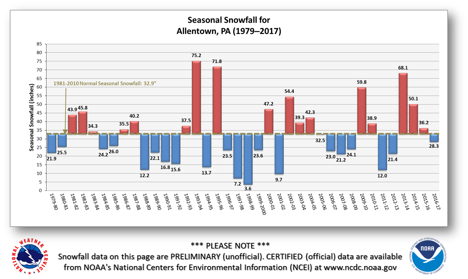
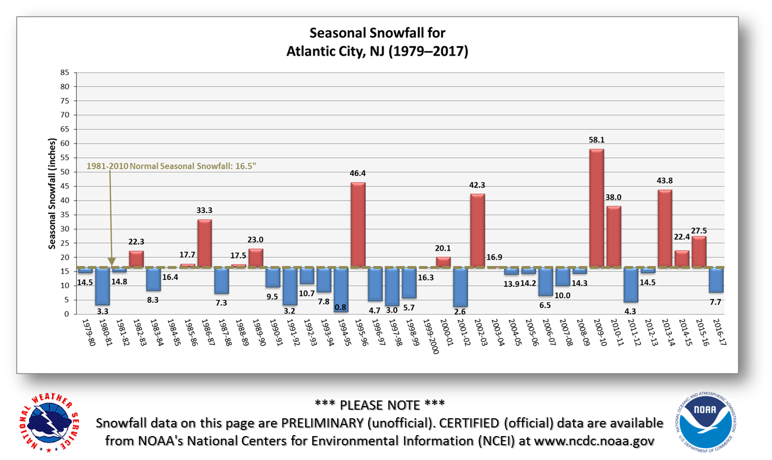
Seasonal Snowfall Totals from 1979-Present (updated May 2017):
Preliminary Top Ten Philadelphia Snow Storms (updated May 2017):
|
Ranking |
Value |
|
Duration |
|
|
|
1 |
30.7 |
|
|
||
|
2 |
28.5 |
|
|
||
|
3 |
23.2 |
|
|||
|
4 |
22.4 |
|
|
||
|
5 |
21.3 |
|
February 11-12 1983 |
|
|
|
6 |
21 |
|
December 25-26 1909 |
||
|
7 |
19.4 |
|
April 3-4 1915 |
|
|
|
8 |
18.9 |
|
February 12-14 1899 |
|
|
|
9 |
18.7 |
|
|
||
|
10 |
16.7 |
|
January 22-24 1935 |
||


 Coastal Flood
 Marine Forecasts
 Text Products
 Climate Information
 Skywarn
 Submit Storm Report
 Weather Event Archives
 Forecast Discussion
 Emergency Managers
 Briefing Page
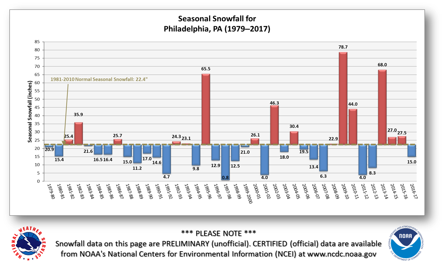