Select a location below to view the current conditions.
-
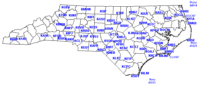
Ahoskie, Tri-County Airport (ASJ)
-
Albemarle, Stanly County Airport (VUJ)
-
Andrews, Andrews-Murphy Airport (RHP)
-
Asheboro, Asheboro Municipal Airport (HBI)
-
Asheville, Asheville Regional Airport (AVL)
-
Beaufort, Michael J Smith Field Airport (MRH)
-
Boone, Watauga County Hospital Heliport (TNB)
-
Burlington, Burlington Alamance Regional Airport (BUY)
-
Chapel Hill, Williams Airport (IGX)
-
Charlotte, Charlotte / Douglas International Airport (CLT)
-
Cherry Point, Marine Corps Air Station (NKT)
-
Clinton, Sampson County Airport (CTZ)
-
Concord, Concord Regional Airport (JQF)
-
Currituck, Currituck County Airport (ONX)
-
Edenton, Northeastern Regional Airport (EDE)
-
Elizabeth City, Elizabeth City Coast Guard Air Station (ECG)
-
Elizabethtown, Curtis L Brown Jr. Field Airport (EYF)
-
Erwin, Harnett County Airport (HRJ)
-
Fayetteville, Fayetteville Regional Airport (FAY)
-
Fayetteville, Fort Bragg / Simmons Army Airfield (FBG)
-
Fayetteville, Pope Air Force Base (POB)
-
Franklin, Macon County Airport (1A5)
-
Gastonia, Gastonia Municipal Airport (AKH)
-
Goldsboro, Goldsboro-Wayne Municipal Airport (GWW)
-
Goldsboro,Seymour-Johnson Air Force Base (GSB)
-
Greensboro, Piedmont Triad International Airport (GSO)
-
Greenville, Pitt-Greenville Airport (PGV)
-
Halifax-Roanoke Rapids, Halifax-Northampton County Regional Airport (IXA)
-
Hatteras, Mitchell Field (HSE)
-
Hickory, Hickory Regional Airport (HKY)
-
Hoffman, Mackall Army Airfield (HFF)
-
Jacksonville Automatic Weather Observing / Reporting System (OAJ)
-
Jacksonville, New River, Marine Corps Air Station (NCA)
-
Jefferson, Ashe County Airport (GEV)
-
Kenansville, Duplin County Airport (DPL)
-
Kill Devil Hills, First Flight Airport (FFA)
-
Kinston, Kinston Regional Jetport at Stallings Field (ISO)
-
Lexington, Davidson County Airport (EXX)
-
Lincolnton, Lincolnton-Lincoln County Regional Airport (IPJ)
-
Louisburg, Franklin County Airport (LHZ)
-
Lumberton, Lumberton Municipal Airport (LBT)
-
Manteo, Manteo-Dare County Regional (MQI)
-
Maxton, Laurinburg-Maxton Airport (MEB)
-
Monroe, Monroe Airport (EQY)
-
Morganton, Morganton-Lenior Airport (MRN)
-
Mount Airy, Mount Airy/Surry County Airport (MWK)
-
New Bern, Craven County Regional Airport (EWN)
-
North Wilkesboro, Wilkes County Airport (UKF)
-
Oxford, Henderson-Oxford Airport (HNZ)
-
Piney Island, Piney Island Bomb Range (NBT)
-
Raleigh-Durham, Raleigh-Durham International Airport (RDU)
-
Reidsville, Rockingham County - Shiloh Airport (SIF)
-
Rockingham, Rockingham-Hamlet Airport (RCZ)
-
Rocky Mount, Rocky Mount-Wilson Airport (RWI)
-
Rutherfordton, Rutherford County-Marchman Field Airport (FQD)
-
Roxboro, Person County Airport (TDF)
-
Salisbury, Rowan County Airport (RUQ)
-
Sanford, Sanford-Lee County Regional Airport (TTA)
-
Shelby, Shelby Municipal Airport (EHO)
-
Siler City, Siler City Municipal Airport (5W8)
-
Smithfield, Johnston County Airport (JNX)
-
Southern Pines, Moore County Airport (SOP)
-
Southport, Southport-Oak Island, Brunswick County Airport (SUT)
-
Statesville, Statesville Municipal Airport (SVH)
-
Swansboro, Bogue Field Marine Corps Auxiliary Field (NJM)
-
Tarboro, Tarboro-Edgecombe Airport (ETC)
-
Wadesboro, Anson County Airport (AFP)
-
Washington, Warren Field Airport (OCW)
-
Whiteville, Columbus County Municipal Airport (CPC)
-
Wilmington, New Hanover International Airport (ILM)
-
Winston Salem, Smith Reynolds Airport (INT)


 Heat Safety
 Statewide Maps
 Forecaster Discussion