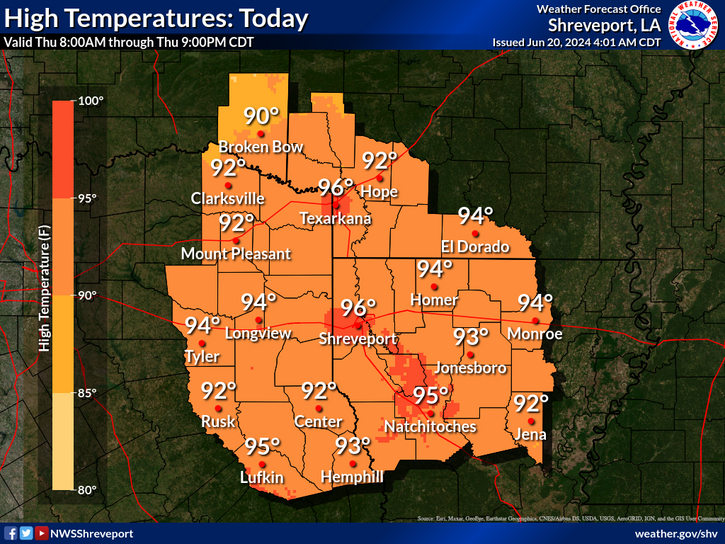
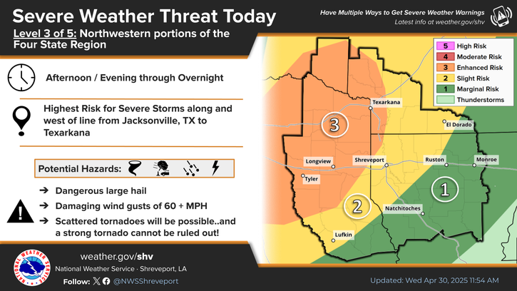
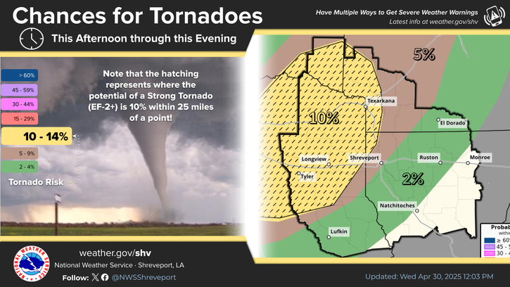
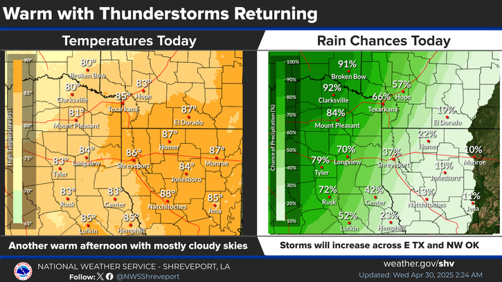
National Weather Service United States Department of Commerce

Severe Thunderstorm and Fire Weather Threats in the Central U.S. Today; Strong Storm in Western Alaska

There is an Enhanced Risk (Level 3 of 5) for severe thunderstorms today with threats for significant severe hail and tornado potential over southern Iowa into northern Missouri and west-central Illinois. Elevated to critical fire weather is possible today due to gusty winds and dry conditions over parts of the southern High Plains and northeastern Montana. Read More >

Click a location below for detailed forecast.

Last Map Update: Tue, Apr. 16, 2024 at 1:24:58 pm CDT

National Weather Service Tulsa, OKNational Weather Service Little Rock, ARNational Weather Service Memphis, TN
National Weather Service Fort Worth/Dallas, TXZoom
Out

National Weather Service Jackson, Mississippi
National Weather Service Houston/Galveston, TXNational Weather Service Lake Charles, LANational Weather Service New Orleans/Baton Rouge


Strong to severe thunderstorms possible mainly north of I-30 on Thursday afternoon.
Mostly cloudy skies are expected once again today ahead of a slow-moving frontal boundary with afternoon highs in the upper 70s/low-to-mid 80s.
Rain chances will increase across much of the region north of I-20 today.
Here are the daily climate statistics for selected cities in the Four State Area.

Latest Text Product Selector (Selected product opens in a new window)


 Current Weather Observations...
Location Time
(CDT)
Weather Vsby.
(SM)
Temp.
(ºF)
Dewpt.
(ºF)
Hum.
(%)
Wind
(mph)
Wind Chill / Heat Index
(ºF)
Pres.
(in)
De Queen AR12:53Overcast10716786SSW 7-29.82
El Dorado AR12:53Overcast10806764SSE 15G23-29.91
Henderson TX12:55Overcast10806969S 10G17-29.90
Idabel OK12:55Light Rain \ Mist46969100S 12-29.84
Longview TX12:53Overcast10776771S 13-29.87
Lufkin TX13:06Overcast10817069SSW 13-29.91
Monroe LA12:53Clear10836554S 13G26-29.95
Mount Pleasant TX12:55Overcast10727092S 10-29.86
Nacogdoches TX12:56Overcast10787384S 13G17-29.92
Natchitoches LA12:55Overcast10816865S 16G24-29.95
Shreveport LA (Regional Airport)12:56Overcast10806865S 16G25-29.90
Shreveport LA (Downtown Airport)13:12Mostly Cloudy10786768S 16G28-29.90
Texarkana AR12:53Light Rain9746676S 10-29.87
Tyler TX12:53Overcast10766773S 14-29.86


Submit Storm Report Local Shreveport Radar Local Hazards Forecast Maps Graphical Forecasts Rivers and Lakes
Submit Storm Report Local Shreveport Radar Local Hazards Local Forecast Page Graphical Forecasts Rivers and Lakes
           
Current Observations Aviation Weather Fire Weather CoCoRAHS Information Hourly Forecasts Tropical Weather
           
Drought Information COOP Program Latest Public Information Statement Weather Radio Past Events Storm Spotter Training
Drought Information Cooperative Observer Program Public Information Statement Weather Radio Past Events Spotter Training