National Weather Service United States Department of Commerce

Areas of Severe Thunderstorms and Excessive Rainfall Tuesday

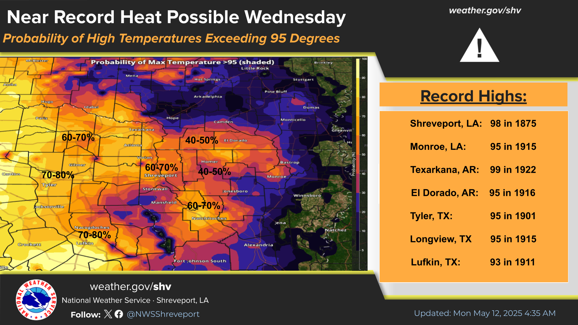
Severe thunderstorms will be possible over parts of the northern Plains Tuesday which could bring large hail, damaging winds, and possible tornadoes. Thunderstorms with heavy to excessive rainfall may produce flooding over parts of the southern High Plains and North Dakota on Tuesday. Read More >

Click a location below for detailed forecast.

Last Map Update: Tue, Jun 2, 2026 at 1:06:31 am CDT


There is a Marginal Risk this afternoon and tonight for severe thunderstorms across portions of Southwestern and South Central Arkansas and Northeast Louisiana. Damaging winds will be the primary threat.
There is a Marginal Risk for excessive heavy rainfall resulting in flash flooding Tuesday afternoon through Tuesday evening mainly along and south of I-20. There is a 5 to 14 percent chance of flash flooding with 25 miles of any point within the Marginal Risk area. Turn around, don't drown!
From June 7 through June 11, chances are trending towards above normal temperatures and above normal precipitation for the entire NWS Shreveport forecast area.
Here are today's climate records for selected sites across the Four State Region.

Latest Text Product Selector (Selected product opens in a new window)


 Current Weather Observations...
Location Time
(CDT)
Weather Vsby.
(SM)
Temp.
(ºF)
Dewpt.
(ºF)
Hum.
(%)
Wind
(mph)
Wind Chill / Heat Index
(ºF)
Pres.
(in)
De Queen AR23:53Clear7767597CALM-29.95
El Dorado AR00:40Lightning Observed10756673CALM-29.96
Henderson TX23:55Clear10777493CALM-29.98
Idabel OK00:35Partly Cloudy97878100CALM-29.98
Longview TX23:53Clear10807481CALM-29.98
Lufkin TX23:53Clear10807687CALM-29.98
Monroe LA23:53Clear10767184W 5-29.99
Mount Pleasant TX00:30Clear10777593CALM-29.99
Nacogdoches TX23:56Clear787590CALM-30.00
Natchitoches LA00:15Clear10777489CALM-29.98
Shreveport LA (Regional Airport)00:56Partly Cloudy10807583SSE 5-29.99
Shreveport LA (Downtown Airport)23:53Clear10837679CALM91 [HI]29.98
Texarkana AR23:53Clear10827681SE 5-29.97
Tyler TX23:53Clear10807276CALM-30.00


Submit Storm Report Local Shreveport Radar Local Hazards Forecast Maps Graphical Forecasts Rivers and Lakes
Submit Storm Report Local Shreveport Radar Local Hazards Local Forecast Page Graphical Forecasts Rivers and Lakes
           
Current Observations Aviation Weather Fire Weather CoCoRAHS Information Hourly Forecasts Tropical Weather
           
Drought Information COOP Program Latest Public Information Statement Weather Radio Past Events Storm Spotter Training
Drought Information Cooperative Observer Program Public Information Statement Weather Radio Past Events Spotter Training