National Weather Service United States Department of Commerce

Severe Thunderstorm and Fire Weather Threats in the Central U.S. Today; Strong Storm in Western Alaska

There is an Enhanced Risk (Level 3 of 5) for severe thunderstorms today with threats for significant severe hail and tornado potential over southern Iowa into northern Missouri and west-central Illinois. Elevated to critical fire weather is possible today due to gusty winds and dry conditions over parts of the southern High Plains and northeastern Montana. Read More >


Severe Weather Awareness Week
Have a Plan Getting the Word Severe Thunderstorms Tornadoes
Flash Flood Safety Winter Weather Lightning Safety
Winter Weather Awareness
While the focus of this week is primarily on severe weather during the Fall season, Winter is just around the corner. Winter can bring a variety of weather conditions, including heavy snow, ice, and cold temperatures. These conditions can make driving conditions hazardous and cause power outages. If you are unprepared, you could be in a life-threatening situation.
 
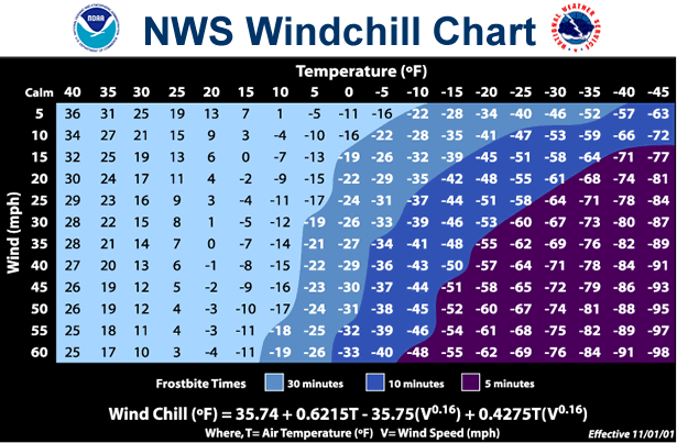
What Is a Winter Storm?

A weather even is defined as a Winter Storm when any of the following conditions occur:

  • Heavy Snow  -  4 or more inches of snow accumulation in 12 hours or less; or 6 or more inches of snow accumulation in 24 hours or less.
     
  • Ice Storm  -  Significant, hazardous, damaging, or possibly dangerous accumulations of freezng rain or freezing drizzle.
     
  • Blizzard Conditions  -  Sustained wind speeds or frequent gusts of 35 MPH or higher and considerable falling/blowing snow causing visibilities to frequently fall to less than one quarter of a mile for 3 hours or more.
 

There are a few different watches, warnings, and advisories that meteorologists from the National Weather Service office in Shreveport will issue depending on which type of winter weather threat is expected.

  • Winter Weather Advisory - Issued when a significant winter weather event is expected within the next 24 hours, but there is not expected to be a serious threat the life and property to warrant a Winter Storm Warning. Typically, this is when snow accumulations of 1 to 3 inches or freezing rain accumulations of less than 0.25 inches are expected to occur. However, if the impact to the public is expected to be higher, such as the storm arriving during a busy travel time, an advisory may be upgraded to one of the warnings products below, such as a Winter Storm Warning.

  • Winter Storm Warning - Issued when Winter Storm conditions (i.e., heavy snow and/or sleet accumulations of at least 0.50 inches) are expected within the next 24 hours.

  • Blizzard Warning - Issued when Blizzard Conditions are expected within the next 24 hours.

  • Ice Storm Warning - Issued when significant hazardous, damaging, or possibly dangerous accumulations of freezing rain/drizzle is expected within the next 24 hours. Typically, freezing rain accumulations are expected to be at least 0.25 inches during an Ice Storm Warning.

  • Winter Storm Watch/Blizzard Watch - Issued when there is a 50 percent or greater chance of Winter Storm or Blizzard conditions within the next 12 to 48 hours.


The National Weather Service in Shreveport also issues a few different advisories and warnings based on expected cold temperatures.

  • Freeze Warning - Issued for the first freeze during the fall/winter. Occasionally issued during the early spring, especially after a long period of unusually warm weather after the growing season has started.

  • Hard Freeze Warning - This criteria varies.
    • For Southeast Oklahoma, Southwest Arkansas, and 7 Northeast Texas counties (Red River, Bowie, Franklin, Titus, Morris, Camp, and Cass): a forecast low temperature in the mid teens or lower.

    • For Louisiana and the remaining Texas Counties: a forecast low temperature of 19 degrees Fahrenheit or lower.
NWS Wind Chill Table
  • Wind Chill Advisory - Issued when the wind chill is expected to be between -14 degrees and +9 degrees Fahrenheit with a sustained wind speed of at least 10 MPH for 2 hours or more.


  • Wind Chill Warning - Issued when the wind chill is expected to be -15 degrees Fahrenheit or lower with a sustained wind speed of 10 MPH for any length of time.


ArkLaTex Average Winter Temperatures By Month   Map Depicting the Historical Probability of a White Christmas
 
Back to Top