
Dangerous, record-breaking heat will continue across most of the central and eastern U.S this week. Heat indices will exceed 100 degrees. Severe storms will be possible from the northern Plains into the Midwest and Great Lakes regions, as well as across the southern Appalachians Thursday, with the primary threat large to very large hail. Critical fire weather to continue in the Four Corners Region Read More >
 |
|||||||||||
|
|||||||||||
| Watches & Warnings, and Reporting Severe Weather | |||||||||||
| Differences Between a Watch and a Warning | |||||||||||
|
A Severe Thunderstorm Watch or a Tornado Watch is issued when atmospheric conditions are favorable for the development of severe weather. Specifically... A Severe Thunderstorm Watch is issued when the primary concern is for large hail one inch in diameter (quarter-sized) or larger and/or damaging thunderstorm winds of at least 58 mph. A Tornado Watch is issued when severe weather is expected, which also includes the possibility of large and/or multiple tornadoes. After coordinating with affected National Weather Service forecast offices, the watch is issued by the Storm Prediction Center in Norman, Oklahoma. The typical size of a watch area is twenty-five thousand square miles and usually takes the shape of a four-sided polygon. The watch typically lasts for six to eight hours. When a watch is issued, it is important to be on the alert for threatening weather and be prepared to move quickly to safety when severe weather develops. Severe Thunderstorm Warnings and Tornado Warnings are issued by local National Weather Service forecast offices when severe thunderstorms or tornadoes are imminent, either as indicated by Doppler radar or when observed & reported by reliable sources, such as Skywarn spotters. A warning usually covers a portion of one to several counties (or parishes) and normally lasts for an hour or less. Pay close attention to the information contained in the warning and take immediate action to protect yourselves. Warnings include important details such as which locations are at greatest risk and what measures you should take to protect yourself. Remember: In a watch...watch the sky. In a warning...take action to protect yourself. |
|||||||||||
|
|
|||||||||||
| We Need Your Reports! | |||||||||||
|
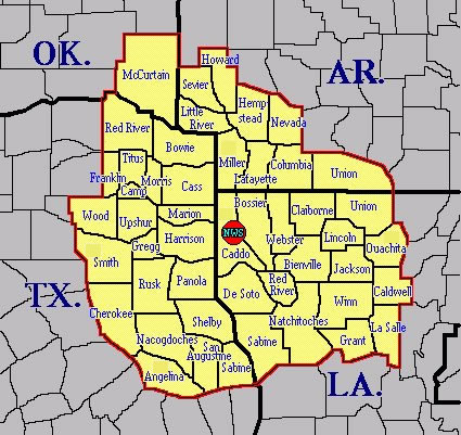
Your severe weather reports provide valuable ground-truth information to the National Weather Service about what exactly a storm is doing. Visual confirmation of severe weather and damage provides additional valuable information to our warnings and to local first responders. We want you to let us know anytime you observe tornadoes, large hail, strong winds, flash flooding, or any damage as a result of hazardous weather. DO NOT put yourself in danger to obtain a report. We value your safety more than any report of severe weather! The National Weather Service office in Shreveport covers 1 county in extreme Southeast Oklahoma, 21 counties in Northeast and East Texas, 9 counties in Southwest Arkansas, and 17 parishes in Northwest Louisiana. You can report severe weather for these counties/parishes in a number of ways:
We will need to know the type of severe weather observed, the location, and the time it occurred. |
 |
||||||||||
| Back to Top | |||||||||||

