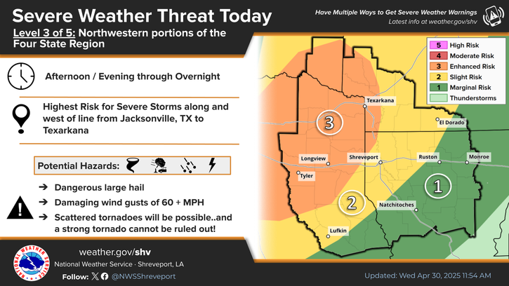
National Weather Service United States Department of Commerce

Heavy Rain and Flooding Along the Central Gulf Coast; Severe Weather in South Texas

Heavy to excessive rainfall could lead to flash flooding over portions of east Texas into southern Mississippi through Wednesday morning. Strong to severe thunderstorms are possible across the southern Great Plains to coastal Louisiana Wednesday. Large hail will be the primary threat, with the greatest risk across south Texas. Read More >

Click a location below for detailed forecast.

Last Map Update: Tue, May 6, 2025 at 10:40:29 pm CDT


The threat of heavy rainfall and flash flooding will return across the region Today into Tonight as the next major storm system arrives. Given already saturated soil conditions, flooding concerns will only be exacerbated with additional rises on area lakes and rivers also expected later this week and beyond.
A Flood Watch remains in effect Today through Tonight for the entire Four State Region. Excessive heavy rainfall is possible through at least this evening which could result in area flooding.
In addition to the flooding rain potential Today, there is also a chance for some severe weather across the region. While the best chances will be across portions of Deep East Texas and Central Louisiana, the entire region is included in some level of risk. Damaging winds and large hail will be primary threats with a few tornadoes also possible during the afternoon and evening.
Mostly cloudy skies tonight, with storms clearing from west to east. Expect patchy fog to develop overnight.
Here are the daily climate statistics for select cities across our Four State Region.

Latest Text Product Selector (Selected product opens in a new window)


 Current Weather Observations...
Location Time
(CDT)
Weather Vsby.
(SM)
Temp.
(ºF)
Dewpt.
(ºF)
Hum.
(%)
Wind
(mph)
Wind Chill / Heat Index
(ºF)
Pres.
(in)
De Queen AR22:11Overcast10605892E 8-29.86
El Dorado AR21:53Overcast10616096-29.85
Henderson TX22:15Mist2 1/2686591CALM-29.87
Idabel OK22:15Overcast105959100ENE 6-29.89
Longview TX22:30Overcast10646396S 3-29.85
Lufkin TX21:53Overcast10696896N 3-29.81
Monroe LA21:53Heavy Rain \ Mist \ Lightning Observed5656393ESE 12G29-29.88
Mount Pleasant TX22:15Overcast10626093N 3-29.87
Nacogdoches TX22:14Overcast6666100ENE 5-29.84
Natchitoches LA22:15Thunder In The Vicinity \ Lightning Observed106565100CALM-29.84
Shreveport LA (Regional Airport)22:23Overcast7686488CALM-29.85
Shreveport LA (Downtown Airport)21:53Overcast10646293SSE 3-29.86
Texarkana AR22:25Overcast10635986ENE 6-29.87
Tyler TX21:53Overcast10666287ENE 6-29.85


Submit Storm Report Local Shreveport Radar Local Hazards Forecast Maps Graphical Forecasts Rivers and Lakes
Submit Storm Report Local Shreveport Radar Local Hazards Local Forecast Page Graphical Forecasts Rivers and Lakes
           
Current Observations Aviation Weather Fire Weather CoCoRAHS Information Hourly Forecasts Tropical Weather
           
Drought Information COOP Program Latest Public Information Statement Weather Radio Past Events Storm Spotter Training
Drought Information Cooperative Observer Program Public Information Statement Weather Radio Past Events Spotter Training